单卫东 , 胡月明, 童昕
Shan Weidong, Hu Yueming, Tong Xin
中图分类号: K901
文献标识码: A
文章编号: 1000-0690(2016)12-1912-08
通讯作者:
收稿日期: 2015-07-11
修回日期: 2016-08-25
网络出版日期: 2016-12-20
版权声明: 2016 《地理科学》编辑部 本文是开放获取期刊文献,在以下情况下可以自由使用:学术研究、学术交流、科研教学等,但不允许用于商业目的.
基金资助:
作者简介:
作者简介:单卫东(1962-),安徽阜阳人,博士,主要从事国土资源管理研究。E-mail:wdshan@mail.mlr.gov.cn
展开
摘要
随着城市化与工业化程度不断加深,产业空间结构不断重组,导致土地供需矛盾日益突出,国土资源无序开发日益严重,因而优化国土资源空间格局,成为生态文明建设的首要任务。同时,科学合理配置土地资源对土地规划提出了更高要求,传统土地规划方法有待改革。在基于尊重自然、顺应自然的开发理念下,总结土地自然过程基础对土地规划的影响,实现“山水路林田生命共同体”的协调规划发展。其次,“大数据”时代的来临,云计算、空间数据整合、云分析等技术对土地规划方法提供新的技术支撑;最后,针对土地规划数据特殊性、移动用户终端的广泛性,提出应创建土地规划云服务平台,使土地规划实现数据集成管理和更新,从而提高土地规划质量。
关键词:
Abstract
With the further process of urbanization and industrialization, the structure of industrial space has been restructuring, which leads to a sharp contradictions between demand and supply of land resources. Because of this serious disorder development of land resources, it is a primary task of ecological civilization to optimize the spatial pattern of land resources.Meanwhile, a higher requirement of land use planning is needed to allocate scientifically and reasonably land resources. Therefore, the traditional methods of land use planning need to be reformed. In this paper, in order to achieve the purpose of coordination development based on the strategy of ‘Community life of mountain-water-forest-cropland-lake’, we follow the concept of respecting and conforming to nature, and summarize the impact of land-based physical process on land use planning. Moreover, with the advent of the era of ‘big data’, we find that many technical methods, such as cloud computing, spatial data integration, cloud analysis, provide a new technical support to land use planning.Finally, considering the special characteristic of land use planning data and mobile user terminal is needed, we suggest that cloud services platform should be created, which enables integrated management and updating data of land planning, thereby, it will improve the quality of land use planning.
Keywords:
土地规划的编制与实施是人类意志作用于地表为主体的自然系统的过程,在此过程中各种错综复杂的自然因素对人类的土地利用决策和行为产生制约。因此,土地规划方案的制定需要基于区域自然要素及其规律这一基础背景。反思中国已开展过的两轮土地利用总体规划和正在实施的第三轮土地利用总体规划,以及相关部门编制的为数较多的土地整治规划、基本农田保护规划等与土地利用有关的相关规划,结合当前人地矛盾日趋尖锐、土地退化、陆地生态系统生产力变化、温室气体排放、生物多样性减少等问题日益凸现的资源环境背景,有必要更加深刻地认知和审视土地规划的自然过程,推动土地规划适应区域自然环境规律、全球环境变化的要求和我国经济社会转型发展的新形势。与此同时,在现代信息技术发展支撑下,“大数据”时代已经降临[1],庞大的数据资源使得各个领域开始了新的量化进程,对土地利用的决策也将要基于大数据的分析与挖掘,在此背景下传统土地规划方法面临新的挑战。
土地规划的编制与实施涉及到以土地为载体的水文、地貌、地质、气候、生物、环境等多方面的自然要素及其系统关系,生物地球化学循环、生态景观格局等自然过程基础,作为影响土地规划编制与实施的重要要素,还没有得到充分的认知和关注[2,3]。为了进一步推进土地规划编制与实施中的人地关系协调,深入落实尊重自然、顺应自然的开发理念,土地规划需要创新规划思路,将自然、生态景观与社会经济发展和谐统一作为规划的核心,落实“山水路林田生命共同体”的人地和谐发展理念[4]。
地球系统的各个圈层之间是通过物理、化学和生物过程相互联系在一起,而陆地表面是大气、土壤和生物圈之间相互作用最为活跃的界面[5]。随着人类活动参与自然地球化学过程的程度越来越高,加速了地球化学循环过程。土地规划过程是直接参与地球化学循环的主要人类活动之一,对生物地球化学循环产生重要影响。生物地球化学过程对土地规划的作用主要表现为(图1):① 气候变化与土地覆被变化的影响。地球化学过程是推动地球物质运动的主要形式之一,促进化学元素的迁移、转化、富集和再生。当前温室气体剧增影响气候变化,碳循环过程成为生物地球化学循环的关键点。土地不仅是陆地生态系统碳汇的自然载体,更是人类经济社会产生碳排放的空间载体[6],土地利用规划带来的土地用地类型的改变,土地覆被的变化均对地球化学过程的碳、氮等微量元素的循环过程产生影响。因此,在土地规划过程中除了考虑影响土地资源利用的社会经济因素以外,更要重视土地的地球化学循环过程[7]; ② 土壤圈土壤生物属性及其物质循环的影响。从土壤圈角度看,土地的地球化学过程主要体现在土地质量上,包括土壤肥沃程度、土壤健康状况、土壤微生物含量等,土地质量的高低主要影响土地规划的功能划分。不同的土地规划对后备土地资源质量要求不同,土地规划过程应以土地质量自然属性为基准,因地制宜制定土地规划方案。如中国基本农田对土地质量要求较高,在土地规划过程就应重视土壤的肥沃程度。有学者认为对土地进行地球化学评估,根据土地地质背景、耕层厚度、坡度、坡向等土地质量的物理属性,对土地规划中初步划定的分级进行检验,可以提高土地规划的科学性,实现合理的土地利用分区[8]。这对当前出现的因经济发展,土地过度开发造成的土地质量下降,水土流失、荒漠化、盐碱化严重等问题提出有效预防措施;③ 陆地生态系统物质、能量循环对土地规划的影响。生物地球化学循环过程在景观形成和发展中起着主导作用,森林、草地、湿地、农地等陆地生态系统的特殊景观蕴含着复杂的生物地球化学过程,要求土地利用协调用地类型与物质循环之间的关系。同时,土地规划对陆地生态系统从自然干预、规划约束、经营管理等方面参与生物地球化学过程。大量研究结果认为土地利用结构变化降低了土地生物多样性[9,10],发展中国家主要是由于农业用地的扩张[11],发达国家由于城镇化水平较高,建设用地扩张使得生物多样性减少[12],这势必将影响土地的可持续利用。正确识别土地规划的自然影响因子是土地规划方案成功的关键。
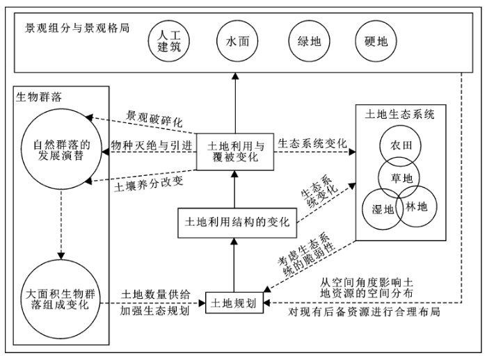
图1 生物地球化学过程与土地规划相互作用机制
Fig.1 The mechanism of interaction between biogeochemical process and land planning
土地利用/覆被变化(LUCC)是全球环境变化的主要因素和驱动力,对全球环境、生物地球化学循环产生重要影响。生态景观格局是土地利用变化在空间的主要表现形式,也是与土地规划过程密切联系的载体,其对土地规划的影响主要表现在以下几个方面(图2):① 从生物群落角度看,自然群落的发展演替过程需要安全的生态环境,而土地利用与覆被变化所造成的景观破碎化、物种灭绝与引进、土壤养分的改变等使得大面积生物群落的组成发生变化,土地规划在考虑数量供给的同时,需要加强生态规划;② 从生态系统角度看,土地是由各种类型的生态系统组成,包括农田生态系统、草地生态系统、林地生态系统、湿地生态系统等,土地利用结构的变化直接体现在生态系统的变化[13]。因此,生态系统的脆弱性是土地规划所要考虑的重要内容。安红岩等[14]从土地规划中的生态服务价值角度分析了生态服务价值导向的土地资源合理利用方式,建立可持续的土地利用模式。吴克宁[15]等从生态功能角度利用生态系统服务价值变化对土地规划方案做出评估、土地规划实施进行评价。这都反映出生态系统服务的脆弱性与土地利用变化密切相关。王佳丽[16]等从土地碳储量角度引入土地利用变化对生态系统服务脆弱性评估方法,研究发现调整土地利用结构、加强土地规划管理可以降低生态系统碳储量对土地利用变化的脆弱性;③ 从景观格局角度看,各类型的下垫面(包括人工建筑、水面、绿地等)的空间形态和结构布局构成了区域的景观格局,景观格局由景观组分和景观格局两部分组成[17]。景观组分从下垫面性质要求土地规划对现有后备资源进行合理布局,景观格局从空间角度影响土地规划对土地资源的空间分布与协调发展。因此,土地规划不仅需要适应区域景观格局,更需要通过自身的合理空间配置来缓解因土地利用引起的土地结构的改变而出现的景观破碎化问题。
图2 生态景观格局与土地规划的作用及反馈机制
Fig.2 The mechanism of interaction and feedback between ecological landscape pattern and land use planning
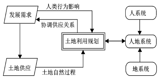
人地关系的内涵随着人类社会的发展而发生变化,包括人对自然的依赖和人的能动地位[18]。人地关系的发展,既表现为人类对“地”的开发利用的广度、深度不断增强,同时也表现为人类系统全方位、多层次的发展对土地资源的需求增长[19]。人地关系矛盾中,人是居于矛盾的主要方面,土地利用是自然和人文环境交互作用的结果,集中体现了人地关系的特征、属性及作用机制[20]。目前,土地利用的人地关系主要表现为中国人口众多、人均耕地占有量较少,城镇化进程较快,建设用地需求较大,土地供需矛盾日益尖锐。因此,人地关系与土地规划的影响主要表现为(图3):①土地利用变化研究是人地关系地域系统的重要载体。土地规划过程不仅强调自然环境的作用,包括土地属性、土地利用现状、规划目标。如不同的土地规划项目中,对土地的地形、地貌、地表景观的合理利用越来越受到重视。另外,土地规划的自然过程将人为因素纳入人地关系系统中,探究人为活动对自然过程的影响。如气候变化的研究将人类活动因素作为一个重要因素考虑在内;②土地规划协调土地供需与人类经济发展的矛盾。土地利用系统与人系统、地系统共同组成了人地复合系统,樊杰等[21]学者从不同空间尺度和时间维度将土地利用与人地关系复杂复合系统进行分析,认为土地利用结构与变化是人地关系地域系统的平面投影。土地规划作为合理利用土地资源的控制手段,可以协调人地复杂系统的各个影响因素,使得土地利用与人地系统和谐发展;③人地协调发展需求引导土地规划方向。人类对土地资源的无限开发利用,导致生态环境恶化,土地资源质量下降、土地供需矛盾尖锐。“山水路林田生命共同体”和谐发展成为当前尊重自然、顺应自然发展的新理念,是人地关系和谐发展的最终需求,这将引导土地利用方式向更加集约有效的方向发展,土地规划必将综合集成考虑不同生态系统的人地系统矛盾,实现人地复杂系统协调发展目标。
图3 土地供求与土地利用规划关系
Fig.3 The relationship between land supply and demandand land use planning
土地规划是一项涉及自然环境、经济、市场、政策等多个领域的综合性复杂系统工程,规划过程考虑因素繁多,计算数据来源多、类型复杂、尺度不一,数据中存在多种类型的数据,包括影像数据、矢量数据、经济数据、结构性数据、非结构数据等,因此,面临多元异构的大数据处理,土地规划需探索新的控制方法。
随着中国城市化、工业化进程的加快,土地供需矛盾日益突出,各功能用地的空间重构现象剧烈。同时,人类经济活动在土地利用过程中对土地资源的地球生物化学循环造成剧烈冲击,对土地生态效益造成重大影响。因此,土地规划过程需要构建土地综合评价指标,遵循土地自然基础过程作为土地规划的首要原则。例如将生物传感器技术运用在土地地球化学过程检测,可以有效地为土地规划提供生态承载力指标数据。目前,生物传感器技术[22]最早广泛应运在物理、化学、生物、医学等领域,Willets等[23]使用生物传感器研究了基因组表层的纳米级响应(LSPR)过程,Park等[24]运用传感器终端传输技术分析了细胞对病原体、毒素的识别过程。Heitzer等[25]研究了传感器技术在环境监测过程的作用。但是,地球生物化学循环过程是一个复杂的物质代谢过程[26],集成了不同层次不同空间的物质信息,具有明显的“大数据”特征,所以,构建多层次多尺度的云平台集成技术,将生物传感器、物联网、空间数据、大数据等技术方法整合到云计算,对土地规划过程的生物化学循环影响实施有效控制。
景观生态规划研究自20世纪50年代以来,产生较大影响力的有E.P.Odum分室模型[27],将土地规划过程的不同生态系统分为不同标准的分室,从微观尺度的群落到宏观尺度的生态系统进行经济效益、生态效益分析、而德国Differentiated Land-use System模型是基于分室模型发展而来,从土地规划的时间空间维度分割环境影响;Forman提出[28]的集中分散规划模型、捷克斯洛伐克[29]LandEP分析框架等等,这些方法都是以最优生态利用为目的。景观生态规划在最初的土地规划中主要表现为农业土地的重新分配,主要目的在于提高土地的自然生产力,但是随着人类对环境保护意识的增强,充分考虑人与环境协调发展的前提下实施土地生态规划。随着3S技术的发展,基于GIS技术的多目标优化方法[30]、GIS二次开发技术[31]、ABM技术[32]广泛运用到土地生态规划中,为实现多目标多层次土地生态规划提供技术支撑。
土地规划过程的控制变量具有随机性和不确定性,尤其是涉及到人地系统、主体权益较为复杂,实现“山水路林田生命共同体”为目标的人地关系和谐发展规划具有挑战性。传统的计量模型、系统动力学模型、元胞自动机模型对复杂系统进行模拟,但是在土地规划系统中人的主观决策性表现突出,此类模型不能很好的模拟地理环境中的动态情景。因此,人地多元系统协调发展的控制方法一方面是多自主体系统[33](MAS),它是复杂适应系统理论、人工生命以及分布式人工智能技术的融合,是可以分析人类与环境交互的多智能体模型;另一方面是情景分析方法, Hawkins等[34]以英国土地规划为例将情景分析分别从景观格局稳定性、生物多样性、生态园林道路三方面分析,Tress等[35]利用情景分析、利益相关者等方面分析丹麦的土地规划,将不同情景进行可视化表达为决策者做出合理规划、保护环境具有重要参考价值。也有学者将公众参与与GIS技术结合开发softGIS[36],为土地规划过程获取更多背景内容。但是,无论是多智能体技术还是情景模拟技术都需要将土地规划全过程的影响因素集成考虑。
土地规划涉及到自然、经济、社会等多方面因素,因此,传统的海量数据难以支撑土地规划方法。而人、机、物三元世界的高度融合引发了数据规模的爆炸式增长和数据模式的高度复杂化,世界已进入网络化的大数据(Big Data)时代[37]。在此背景下,各行各业对数据的依赖性有增无减,甚至以数据为基础的定量分析方法也有逐步取代耗时耗力的以专家为基础的定性分析方法的趋势[38]。对此,为应对“大数据”环境下的土地复杂数据特征与资源环境,需要转变土地规划决策驱动根源,由传统的“目标驱动决策”向“数据驱动决策”转化。
云计算(Cloud Computing)是利用分布式处理技术、并行处理技术和网络计算技术形成的一种基于互联网的新型计算技术。一个云计算的平台能够按需进行动态地部署(provision)、配置(configuration)、重新配置(reconfigure)以及取消服务(deprovision)等[39]。在云计算环境下研究土地信息数据管理综合服务平台对构建国土信息化来说是一项充满挑战性和创新性的工作。多年来,土地管理部门积累了海量的甚至是超海量的土地资源管理数据,如何进行高效处理以便能更科学地制定土地规划方案是新形势下土地管理部门亟需解决的问题。“大数据”背景下,云计算技术为解决超海量信息的土地资源管理问题提供了一条更科学的途径,为实现土地资源信息的全面共享和社会化服务指明了方向[40],为构建土地规划智能服务决策支持提供了更高效、更低成本和更人性化的新技术支持。土地规划既要获取土地自然要素信息供决策分析,又要通过方案实施获得规划效果以修正土地利用行为。在此过程中,基于云技术手段搭建起新的数据访问和信息共享架构,不仅能够有效地解决“信息孤岛”和“数字鸿沟”等问题,而且能够实现海量数据高效管理、深度分析挖掘、长久保存、智能辅助决策的功能,从而推动土地规划向社会化信息服务、公众参与和综合调控方向发展。因此,大数据时代云计算和土地资源信息管理与服务相结合,是应对土地信息发展机遇和挑战的必然要求,也是未来土地规划方法革新的主要方向。
传统的土地规划理念是一种单一场所的土地资源利用短期静态规划,基于生态学原则的土地规划是考虑多时间尺度上土地资源生物多样性、多场所相互作用的动态规划,也是将内容、背景、机制、多样性、等级尺度融合考虑的多目标动态规划[41]。目前,国内学者对云服务的土地规划与生态学原则结合研究较为欠缺,尤其是在“大数据”背景下,需要不断探索生态规划海量数据的集成方法。因此,一方面将土地规划各个决策系统与生态网络规划集成系统移植到云计算环境下,实现集成化、智能化、网络化发展方向。另一方面土地规划的不同评价模型与生态模块整合模拟,以情景理论为指导,开发情景优化分析的自动判读方法。
快速城市化进程加速了土地利用结构的转变,不仅导致土地景观破碎化严重,生态环境脆弱性增加,而且农民土地权益受到损失[42],激化人地发展矛盾,因此探索符合“山水路林田生命共同体”和谐发展的土地规划管理体系,探索市场机制发挥配置土地的作用[43]。“云计算”服务为实现土地资源管理、土地规划、土地经营等不同目标的综合管理提供了高度集成、便利的智能化决策服务。在此决策过程中,针对不同的土地规划目标,可以实现不同规划“自上而下”完整的规划编制体系,不仅能够实现土地资源的有效合理利用,达到土地利用与生态修复的网络化规划目标[44],更能够解决土地规划过程遇到的土地资源争夺,城乡建设用地空间布局政策优化[45]以及城镇化进程中较为突出的城市棕地污染[46]问题。利用土地资源特征,基于云服务平台结合现有的基于AO[47]的土地规划,将土地规划行业管理、公众参与综合集成考虑,探索创新“大数据”环境下的土地规划管理技术。
随着中国科学发展观的贯彻实施和生态文明建设的不断深入,越来越重视国土空间规划,而主体功能区战略在优化国土空间开发格局中的作用和效果越来越凸显。
首先,土地规划作为主体功能区规划的核心,需深入贯彻生态文明建设的理念。以遵循尊重自然、顺应自然的视角出发,将土地地球化学循环、生态景观、人地关系综合纳入规划范畴,实现“山水路林田生命共同体”的规划框架;其次,“大数据”时代的来临,为土地规划过程解决数据量庞杂、数据结构参差不齐、数据类型多样等问题提供了技术支撑。利用生物传感器、生态遥感、物联网、大数据、云计算等数据分析技术,优化土地规划数据结构,提高土地规划质量,整合土地规划自然、经济、生态资源,构建多层次、多尺度、多变量的规划控制指标,提升土地规划科学性;
第三,基于云服务的土地规划将是“大数据”时代土地规划的主要趋势,通过集成土地规划多项数据,针对不同层次的用户终端,构建不同的人性化人机交互界面,拓宽土地规划成果应用领域,集成主体功能区规划过程不同类型用地之间的数据管理平台,发挥土地规划在优化国土空间格局的作用。
致谢:感谢北京大学城市与环境学院冯长春教授、南京大学地理与海洋科学学院李升峰副教授在交流讨论中无私贡献的科学观点。
The authors have declared that no competing interests exist.
| [1] |
|
| [2] |
利用生物地球化学模型研究草地生态系统土地变化对生态环境的影响 [J].https://doi.org/10.3321/j.issn:1009-2242.2003.01.043 URL [本文引用: 1] 摘要
分析了生物地球化学循环中植物-土壤生态系统的有机物动态,土壤有机质(SOM)主要库类--土壤C,N, P, S循环特点;阐述了土壤有机质的生物地球化学循环模型 CENTURY结构.利用CENTURY模型模拟土地利用变化情形下内蒙古草原生态典型区土壤有机质动态.由数值模拟结果分析看,CENTURY对自然和人为活动影响下生态系统的土壤有机质动态有良好的模拟能力,同时又可有效地反映土地利用类型变化对生态环境和土壤侵蚀的影响.
Eco-environment dynamic under landuse change in grassland ecosystem based on Biogeochemical Model .https://doi.org/10.3321/j.issn:1009-2242.2003.01.043 URL [本文引用: 1] 摘要
分析了生物地球化学循环中植物-土壤生态系统的有机物动态,土壤有机质(SOM)主要库类--土壤C,N, P, S循环特点;阐述了土壤有机质的生物地球化学循环模型 CENTURY结构.利用CENTURY模型模拟土地利用变化情形下内蒙古草原生态典型区土壤有机质动态.由数值模拟结果分析看,CENTURY对自然和人为活动影响下生态系统的土壤有机质动态有良好的模拟能力,同时又可有效地反映土地利用类型变化对生态环境和土壤侵蚀的影响.
|
| [3] |
土地利用数据用于景观格局分析的研究 [J].
在阐述景观格局定量分析的基础上,探讨了土地利用现状数据用于景观格局分析的整合内容、过程及方法,并例举了用于景观格局分析的计算方法与分析,以期说明土地利用数据的多元应用性。
Land use data application to landscape pattern analysis .
在阐述景观格局定量分析的基础上,探讨了土地利用现状数据用于景观格局分析的整合内容、过程及方法,并例举了用于景观格局分析的计算方法与分析,以期说明土地利用数据的多元应用性。
|
| [4] |
主体功能区战略与优化国土空间开发格局 [J].
生态文明建设的首要任务是优化国土空间开发格局,实施主体功能区战略、形成主体功能区布局是优化空间格局的战略重点。文章从发达国家开展国土空间规划的特征分析入手,结合我国长期缺失全国国土远景规划所产生的空间开发无序、区域发展失衡以及各地盲目推进工业化和城市化等问题的解剖,阐释了主体功能区战略在尊重资源环境承载能力、区分不同地区主体功能、控制开发强度和调整空间结构以及生态产品理论和应用等方面的创新,论证了主体功能区规划在我国国土空间布局规划体系中的战略性、基础性和约束性地位。进而从“1、2、3、4”战略任务入手论述了优化国土空间开发格局的主要方面:“1”是建设一个美好家园,“2”是促进陆地与海洋两大国土空间的统筹发展,“3”是构建我国国土空间的城市化、农业和生态安全3大战略格局,“4”是形成我国优化、重点、限制和禁止开发4类主体功能区域。最后,从咨询建议的提出、指标体系建立、国土空间评价、区划草案研制以及构建基础理论、研制技术规程等方面,系统介绍了中科院研究团队在过去10年间面向主体功能区战略的形成所发挥的科技支撑作用。
The strategy of major function oriented zoning and the optimization of territorial development patterns .
生态文明建设的首要任务是优化国土空间开发格局,实施主体功能区战略、形成主体功能区布局是优化空间格局的战略重点。文章从发达国家开展国土空间规划的特征分析入手,结合我国长期缺失全国国土远景规划所产生的空间开发无序、区域发展失衡以及各地盲目推进工业化和城市化等问题的解剖,阐释了主体功能区战略在尊重资源环境承载能力、区分不同地区主体功能、控制开发强度和调整空间结构以及生态产品理论和应用等方面的创新,论证了主体功能区规划在我国国土空间布局规划体系中的战略性、基础性和约束性地位。进而从“1、2、3、4”战略任务入手论述了优化国土空间开发格局的主要方面:“1”是建设一个美好家园,“2”是促进陆地与海洋两大国土空间的统筹发展,“3”是构建我国国土空间的城市化、农业和生态安全3大战略格局,“4”是形成我国优化、重点、限制和禁止开发4类主体功能区域。最后,从咨询建议的提出、指标体系建立、国土空间评价、区划草案研制以及构建基础理论、研制技术规程等方面,系统介绍了中科院研究团队在过去10年间面向主体功能区战略的形成所发挥的科技支撑作用。
|
| [5] |
地表面物理过程与生物地球化学过程耦合反馈机理的模拟研究 [J].https://doi.org/10.1088/0256-307X/15/8/013 URL [本文引用: 1] 摘要
利用大气-植被相互作用模式(AVIM)研究地表面物理过程与生物地球化学过程耦合的机理和 实现方法,其基础是植物与非生物环境之间物质和能量交换等物理过程影响植物的生理生长过程,使得植被宏观形态和相应的地表的动力学参数上发生显著变化,又 反过来作用于植被与大气、土壤之间的物理交换过程。这种气候与生物圈双向反馈过程是在季节和年际时间尺度上的主要相互作用机理。应用AVIM于内蒙古半干 旱草原,模拟了在大气状况强
A simulation study of coupled feedback mechanism between physical and biogeochemical processes at the surface .https://doi.org/10.1088/0256-307X/15/8/013 URL [本文引用: 1] 摘要
利用大气-植被相互作用模式(AVIM)研究地表面物理过程与生物地球化学过程耦合的机理和 实现方法,其基础是植物与非生物环境之间物质和能量交换等物理过程影响植物的生理生长过程,使得植被宏观形态和相应的地表的动力学参数上发生显著变化,又 反过来作用于植被与大气、土壤之间的物理交换过程。这种气候与生物圈双向反馈过程是在季节和年际时间尺度上的主要相互作用机理。应用AVIM于内蒙古半干 旱草原,模拟了在大气状况强
|
| [6] |
|
| [7] |
土地资源合理利用评价研究综述 [J].https://doi.org/10.3969/j.issn.1001-8158.2001.02.004 URL [本文引用: 1] 摘要
对国内外土地资源合理利用评价、指标体系建立等方面的研究进展进行了综述,并对不同评价方法和不同评价指标体系的优缺点进行了分析,提出了未来土地资源合理利用评价的发展方向、评价指标的构建思路以及不同尺度的指标转换和指标量化方法。
Summary of evaluation research to rational utilization of land resources .https://doi.org/10.3969/j.issn.1001-8158.2001.02.004 URL [本文引用: 1] 摘要
对国内外土地资源合理利用评价、指标体系建立等方面的研究进展进行了综述,并对不同评价方法和不同评价指标体系的优缺点进行了分析,提出了未来土地资源合理利用评价的发展方向、评价指标的构建思路以及不同尺度的指标转换和指标量化方法。
|
| [8] |
土地质量地球化学评估在土地规划和管理中的作用 [J].https://doi.org/10.3969/j.issn.1671-1947.2012.06.011 URL [本文引用: 1] 摘要
论述了土地规划及土地评价的内 容、方法,着重阐述了土地评价中土地质量地球化学评估的定义、原则、任务、工作程序和技术方法.通过实例说明了土地质量地球化学评估在土地质量评价、农业 用地分等定级中的应用.认为土地质量地球化学评估为土地质量评价和土地规划与管理提供了重要的依据.
Geochemical Assessment for Land Quality: Function in land planning and management .https://doi.org/10.3969/j.issn.1671-1947.2012.06.011 URL [本文引用: 1] 摘要
论述了土地规划及土地评价的内 容、方法,着重阐述了土地评价中土地质量地球化学评估的定义、原则、任务、工作程序和技术方法.通过实例说明了土地质量地球化学评估在土地质量评价、农业 用地分等定级中的应用.认为土地质量地球化学评估为土地质量评价和土地规划与管理提供了重要的依据.
|
| [9] |
土地利用变化对生物多样性的影响 [J].https://doi.org/10.3969/j.issn.1674-5906.2008.03.077 URL [本文引用: 1] 摘要
土地利用变化对生物多样性影响是生物多样性受到威胁的重要因素.文章对土地利用变化对基因多样性、物种多样性、生态系统多样性影响方面的研究进行了总结分析,并提出了新的展望.土地利用变化对基因多样性的影响涉及了对物种生境的隔离、农牧业活动对物种改良和生境条件的改变方面,目前还主要集中在对少数物种繁殖过程方面影响的研究;土地利用变化对物种多样性影响包括对物种优势度和丰富度、种间关系、物种分布格局、物种入侵和灭绝方面的影响,目前对物种丰富性和多样性影响方面研究较多,对物种灭绝、物种入侵和种间关系影响方面的研究极少,且还限于大型动物和植物,对微生物和小型动植物研究却很少;土地利用变化对生态系统的影响涉及了对生态系统结构组成及分布方面的影响.另外,目前缺少土地利用变化对基因多样性、物种多样性和生态系统多样性综合影响方面的研究,难以量化和预测土地利用变化对生物多样性影响效应.未来需要综合考虑基因多样性、物种多样性和生态系统多样性方面,系统开展土地利用变化对生物多样性影响的趋势和机制方面的研究,定量预测土地利用变化对生物多样性的影响.
Effects of land use change on the biodiversity .https://doi.org/10.3969/j.issn.1674-5906.2008.03.077 URL [本文引用: 1] 摘要
土地利用变化对生物多样性影响是生物多样性受到威胁的重要因素.文章对土地利用变化对基因多样性、物种多样性、生态系统多样性影响方面的研究进行了总结分析,并提出了新的展望.土地利用变化对基因多样性的影响涉及了对物种生境的隔离、农牧业活动对物种改良和生境条件的改变方面,目前还主要集中在对少数物种繁殖过程方面影响的研究;土地利用变化对物种多样性影响包括对物种优势度和丰富度、种间关系、物种分布格局、物种入侵和灭绝方面的影响,目前对物种丰富性和多样性影响方面研究较多,对物种灭绝、物种入侵和种间关系影响方面的研究极少,且还限于大型动物和植物,对微生物和小型动植物研究却很少;土地利用变化对生态系统的影响涉及了对生态系统结构组成及分布方面的影响.另外,目前缺少土地利用变化对基因多样性、物种多样性和生态系统多样性综合影响方面的研究,难以量化和预测土地利用变化对生物多样性影响效应.未来需要综合考虑基因多样性、物种多样性和生态系统多样性方面,系统开展土地利用变化对生物多样性影响的趋势和机制方面的研究,定量预测土地利用变化对生物多样性的影响.
|
| [10] |
河南省白龟山水库滨湖带土地利用对生物多样性的影响 [J].https://doi.org/10.3969/j.issn.0517-6611.2010.04.118 URL [本文引用: 1] 摘要
根据野外调查数据,采用层次分 析法和专家调查法,构建了土地利用对生物多样性影响的评价指标体系。利用该指标体系综合评估了白龟山水库湖滨带土地利用对生物多样性的影响。结果表明,白 龟山水库湖滨带各种类型的土地利用已经严重影响了区域内生物多样性,其中建设用地对生物多样性影响最为强烈。
Effects of the land use on the biodiversity in the lakeside zone of the Baiguishan reservoir of Henan province .https://doi.org/10.3969/j.issn.0517-6611.2010.04.118 URL [本文引用: 1] 摘要
根据野外调查数据,采用层次分 析法和专家调查法,构建了土地利用对生物多样性影响的评价指标体系。利用该指标体系综合评估了白龟山水库湖滨带土地利用对生物多样性的影响。结果表明,白 龟山水库湖滨带各种类型的土地利用已经严重影响了区域内生物多样性,其中建设用地对生物多样性影响最为强烈。
|
| [11] |
Crop expansion and conservation priorities in tropical countries [J]. |
| [12] |
Transparent planning for biodiversity anddevelopment in the urban fringe [J].https://doi.org/10.1016/j.landurbplan.2012.09.001 URL [本文引用: 1] 摘要
In Australia, over 50% of threatened species occur within the urban fringe and accelerating urbanization is now a key threat. Biodiversity near and within urban areas brings much social benefit but its maintenance involves complex trade-offs between competing land uses. Urban design typically views biodiversity as a development constraint, not a value to be enhanced into the future. We argue that decisions could be more transparent and systematic and we demonstrate that efficient development solutions can be found that avoid areas important for biodiversity. We present a case study in the context of land use change across the city of Wyndham, a local Government west of Melbourne, Australia. We use reserve design tools in a novel way to identify priority development sites, based on a synthesis of ecological, social and economic data. Trade-offs between biodiversity conservation and other key development objectives and constraints (transport planning, flood risk and food production) are quantified. The analysis can be conducted dynamically with visually compelling output, facilitating more transparent, efficient and democratically derived urban planning solutions. We suggest that government agencies could adopt similar approaches to identify efficient planning solutions for both biodiversity and development in urban environments.
|
| [13] |
土地利用规划环境影响评价 [J].Zhang Xiaoling et al. Preliminary research on environment impact assessment of land use planning . |
| [14] |
生态服务价值评价在山区城市土地规划中的应用——以万源市太平镇为例 [J].
生态系统服务价值的变化决定着区域的可持续发展,其评估已成为生态学研究的热点之一,其研究结果对维持地区生态平衡、合理利用土地资源、建立可持续的土地利用模式等具有重要意义。本文在综合已有研究的基础上,通过估算万源市太平镇不同海拔高度土地生态服务价值量,探讨经济发展与生态服务价值变化的关系。结果表明,城市规划区的自然生态系统服务功能的价值是不可忽视的,自然生态系统无论是从物质上还是经济上,都为万源市太平镇的国民经济和社会可持续发展提供者重要支撑。从生态系统服务功能角度,海拔750 m高程是太平镇城市用地扩张的控制线。
Application of ecological service value evaluation in the land use planning of mountain city:A case study of Taiping town in Wanyuan city .
生态系统服务价值的变化决定着区域的可持续发展,其评估已成为生态学研究的热点之一,其研究结果对维持地区生态平衡、合理利用土地资源、建立可持续的土地利用模式等具有重要意义。本文在综合已有研究的基础上,通过估算万源市太平镇不同海拔高度土地生态服务价值量,探讨经济发展与生态服务价值变化的关系。结果表明,城市规划区的自然生态系统服务功能的价值是不可忽视的,自然生态系统无论是从物质上还是经济上,都为万源市太平镇的国民经济和社会可持续发展提供者重要支撑。从生态系统服务功能角度,海拔750 m高程是太平镇城市用地扩张的控制线。
|
| [15] |
基于生态系统服务功能价值理论的土地利用规划环境影响评价——以安阳市为例 [J].https://doi.org/10.3969/j.issn.1001-8158.2008.02.004 URL [本文引用: 1] 摘要
研究目的:对土地利用规划环境影响的评价方法进行实证研究,为土地利用规划修编提供依据.研究方法:以生态系统服务功能价值理论为基础,结合区域实际确定安阳市各种土地利用生态系统的单位面积服务功能价值,根据安阳市规划期内的各种土地利用类型的面积变化,预测安阳市新一轮土地利用规划初步方案实施前后生态系统服务功能总价值的变化,评价实施规划将产生的生态环境影响.研究结果:安阳市2004-2020年土地利用规划初步方案是切实可行的,方案的实施将给安阳市带来良好的生态环境效益.研究结论:生态系统服务功能价值理论的引入,实现了土地利用规划环境影响定性分析与定量评价的结合,对正确制定土地利用决策具有意义.
The environmental impact assessment of land use planning based on the theory of ecosystem services value: Taking Anyang as an example .https://doi.org/10.3969/j.issn.1001-8158.2008.02.004 URL [本文引用: 1] 摘要
研究目的:对土地利用规划环境影响的评价方法进行实证研究,为土地利用规划修编提供依据.研究方法:以生态系统服务功能价值理论为基础,结合区域实际确定安阳市各种土地利用生态系统的单位面积服务功能价值,根据安阳市规划期内的各种土地利用类型的面积变化,预测安阳市新一轮土地利用规划初步方案实施前后生态系统服务功能总价值的变化,评价实施规划将产生的生态环境影响.研究结果:安阳市2004-2020年土地利用规划初步方案是切实可行的,方案的实施将给安阳市带来良好的生态环境效益.研究结论:生态系统服务功能价值理论的引入,实现了土地利用规划环境影响定性分析与定量评价的结合,对正确制定土地利用决策具有意义.
|
| [16] |
区域生态系统服务对土地利用变化的脆弱性评估——以江苏省环太湖地区碳储量为例 [J].https://doi.org/10.11849/zrzyxb.2010.04.004 URL [本文引用: 1] 摘要
文章在评述生态系统服务对全球变化的脆弱性研究概况的基础上,认为在生态系统服务退化和不可持续的状态下,改变土地利用变化对降低生态系统服务脆弱性具有重要意义。论文引入了生态系统服务对土地利用变化脆弱性评估方法,分析了生态系统服务对土地利用类型转变、土地利用类型渐变、土地管理方式变化的脆弱性响应机理,以江苏省环太湖地区碳储量为例进行实证研究。结果表明:①在1980—1990年、1990—2000年、2000—2005年3个时间段,农田、林地的显著减少和建设用地的急剧增加致使生态系统碳储量对土地利用强度变化表现得愈加脆弱,土地利用强度指数每增加一个单位,碳储量分别减少0.90 Tg、1.68 Tg、1.69 Tg;②2005—2015年间,通过对农田、林地、建设用地的规划控制,可以降低生态系统碳储量的脆弱性,土地利用强度指数每增加一个单位,碳储量分别由规划控制前减少0.50 Tg变为增加0.62Tg。据此得出结论,合理调整土地利用结构、加强规划管理可以降低生态系统碳储量对土地利用变化的脆弱性。最后,针对研究中存在的一些不足之处,提出了进一步研究的建议。
Assessment on the vulnerability of ecosystem services to land use change-A case study of carbon stock of Taihu Lake District in Jiangsu province .https://doi.org/10.11849/zrzyxb.2010.04.004 URL [本文引用: 1] 摘要
文章在评述生态系统服务对全球变化的脆弱性研究概况的基础上,认为在生态系统服务退化和不可持续的状态下,改变土地利用变化对降低生态系统服务脆弱性具有重要意义。论文引入了生态系统服务对土地利用变化脆弱性评估方法,分析了生态系统服务对土地利用类型转变、土地利用类型渐变、土地管理方式变化的脆弱性响应机理,以江苏省环太湖地区碳储量为例进行实证研究。结果表明:①在1980—1990年、1990—2000年、2000—2005年3个时间段,农田、林地的显著减少和建设用地的急剧增加致使生态系统碳储量对土地利用强度变化表现得愈加脆弱,土地利用强度指数每增加一个单位,碳储量分别减少0.90 Tg、1.68 Tg、1.69 Tg;②2005—2015年间,通过对农田、林地、建设用地的规划控制,可以降低生态系统碳储量的脆弱性,土地利用强度指数每增加一个单位,碳储量分别由规划控制前减少0.50 Tg变为增加0.62Tg。据此得出结论,合理调整土地利用结构、加强规划管理可以降低生态系统碳储量对土地利用变化的脆弱性。最后,针对研究中存在的一些不足之处,提出了进一步研究的建议。
|
| [17] |
城市景观格局的大气环境效应研究进展 [J].https://doi.org/10.3321/j.issn:1001-8166.2006.10.005 URL [本文引用: 1] 摘要
城市规划不仅需要适应区域气候,更需要通过城市自身的合理空间配置来缓解因城市化引起的城市大气环境问题,因此,加强城市景观格局大气环境效应的研究对于提高城市规划的水平具有重要的意义。从城市下垫面的大气环境效应、大气数值模式、遥感应用技术以及城市规划的气候适应性等方面综述了城市景观格局的大气环境效应的研究进展,并分析了城市景观格局的大气环境效应应用于城市规划面临的主要问题。尽管城市景观组分的大气环境效应已经得到充分认识和应用。但是景观组分的空间组合,即城市景观格局对城市大气环境的影响及其应用研究仅仅处于起步的阶段。为了推动城市景观格局的大气环境效应研究并应用于城市规划之中,除了需要深入研究“格局影响过程”的机制外,还需要重点解决2个问题:一是寻找能够用来研究城市景观格局与大气环境相互作用的格局参数;二是确认具有一般意义的理想城市景观格局模式。
Advances in the impacts of urban landscape pattern on urban air environment .https://doi.org/10.3321/j.issn:1001-8166.2006.10.005 URL [本文引用: 1] 摘要
城市规划不仅需要适应区域气候,更需要通过城市自身的合理空间配置来缓解因城市化引起的城市大气环境问题,因此,加强城市景观格局大气环境效应的研究对于提高城市规划的水平具有重要的意义。从城市下垫面的大气环境效应、大气数值模式、遥感应用技术以及城市规划的气候适应性等方面综述了城市景观格局的大气环境效应的研究进展,并分析了城市景观格局的大气环境效应应用于城市规划面临的主要问题。尽管城市景观组分的大气环境效应已经得到充分认识和应用。但是景观组分的空间组合,即城市景观格局对城市大气环境的影响及其应用研究仅仅处于起步的阶段。为了推动城市景观格局的大气环境效应研究并应用于城市规划之中,除了需要深入研究“格局影响过程”的机制外,还需要重点解决2个问题:一是寻找能够用来研究城市景观格局与大气环境相互作用的格局参数;二是确认具有一般意义的理想城市景观格局模式。
|
| [18] |
21世纪人地关系研究前瞻 [J].https://doi.org/10.3321/j.issn:1000-0585.2002.01.002 URL [本文引用: 1] 摘要
人地关系包括人对自然的依赖性和人的能动地位 ,人与自然关系的内涵随着人类社会的发展而发生变化。人地关系研究是近代地理学发展的基础 ,地理学中流行的环境决定论、可能论、文化景观学和人类生态学等都是聚焦于人地关系研究的不同学派。地球系统科学领域的研究重心是揭示人与自然的相互作用及所应采取的对策。信息时代人地关系的特征与工业时代有较大差别。人与自然的作用方式和强度将有显著不同 ,人类将全面系统地深化对自然的认识 ,人类活动空间将发生巨大变化 ,时空观念正在发生转变。知识与科技的作用 ,正成为社会经济发展的主要驱动力。由于地球的整体性和地球各圈层的相互作用 ,许多全球环境问题成为世界各国和社会公众关切的热点。人地关系研究的重要前沿领域包括 :全球环境变化及其区域响应 ,区域可持续发展及人地关系机理调控 ,社会生态与环境伦理研究与体系构建
Prospects of studies on man-land relationship in the 21st century .https://doi.org/10.3321/j.issn:1000-0585.2002.01.002 URL [本文引用: 1] 摘要
人地关系包括人对自然的依赖性和人的能动地位 ,人与自然关系的内涵随着人类社会的发展而发生变化。人地关系研究是近代地理学发展的基础 ,地理学中流行的环境决定论、可能论、文化景观学和人类生态学等都是聚焦于人地关系研究的不同学派。地球系统科学领域的研究重心是揭示人与自然的相互作用及所应采取的对策。信息时代人地关系的特征与工业时代有较大差别。人与自然的作用方式和强度将有显著不同 ,人类将全面系统地深化对自然的认识 ,人类活动空间将发生巨大变化 ,时空观念正在发生转变。知识与科技的作用 ,正成为社会经济发展的主要驱动力。由于地球的整体性和地球各圈层的相互作用 ,许多全球环境问题成为世界各国和社会公众关切的热点。人地关系研究的重要前沿领域包括 :全球环境变化及其区域响应 ,区域可持续发展及人地关系机理调控 ,社会生态与环境伦理研究与体系构建
|
| [19] |
土地利用的人地关系透视 [J].https://doi.org/10.3969/j.issn.1003-2363.2002.01.003 URL [本文引用: 1] 摘要
人地关系的协调是可持续发展战略的基本内容,土地利用是人地关系的核心问题。文章基于对土地综合体属性的把握,分析了土地在人地系统中的基础作用。不同的土地利用类型决定了人地系统的属性特征具有自然和社会两重属性。从土地开发的历史角度探讨了人类系统的发展及其在人地关系构建中的主导作用,最后得出了人地系统的作用机制。
Prospect of man-earth relationship in land-use .https://doi.org/10.3969/j.issn.1003-2363.2002.01.003 URL [本文引用: 1] 摘要
人地关系的协调是可持续发展战略的基本内容,土地利用是人地关系的核心问题。文章基于对土地综合体属性的把握,分析了土地在人地系统中的基础作用。不同的土地利用类型决定了人地系统的属性特征具有自然和社会两重属性。从土地开发的历史角度探讨了人类系统的发展及其在人地关系构建中的主导作用,最后得出了人地系统的作用机制。
|
| [20] |
人地关系研究中的土地利用特征指标分析——以兰州市为例 [J].
土地利用作为人地关系研究的核心内容,是人地关系的最直接的反映。本文以兰州市为例,对其土地利用的特征指标进行定量分析,以反映该地区人地关系的特征及存在的问题,并提出相应的解决对策。
Analysis on the characteristic index of land-use in man-earth relationship-Taking Lanzhou as a case .
土地利用作为人地关系研究的核心内容,是人地关系的最直接的反映。本文以兰州市为例,对其土地利用的特征指标进行定量分析,以反映该地区人地关系的特征及存在的问题,并提出相应的解决对策。
|
| [21] |
土地利用变化研究的人文地理视角与新命题 [J].https://doi.org/10.3969/j.issn.1007-6301.2003.01.001 URL [本文引用: 1] 摘要
从地理学最高层面的科学难点问题—"综合性"出发,本文阐述了土地利用变化是人地关系地域系统研究的核心领域的观点。并从人文地理学的视角,解析了土地利用变化驱动机制的三个重要内容:消费需求拉动、经济效益驱使、以及协调发展理念作用等;提出了规制、对策的经济评价、以及环境伦理等三个人文地理学研究土地利用变化的新命题。
The human geography view of land use study and new proposition .https://doi.org/10.3969/j.issn.1007-6301.2003.01.001 URL [本文引用: 1] 摘要
从地理学最高层面的科学难点问题—"综合性"出发,本文阐述了土地利用变化是人地关系地域系统研究的核心领域的观点。并从人文地理学的视角,解析了土地利用变化驱动机制的三个重要内容:消费需求拉动、经济效益驱使、以及协调发展理念作用等;提出了规制、对策的经济评价、以及环境伦理等三个人文地理学研究土地利用变化的新命题。
|
| [22] |
A biosensor that uses ion-channel switches [J]. |
| [23] |
Localized surface plasmon resonance spectroscopy and sensing [J].https://doi.org/10.1146/annurev.physchem.58.032806.104607 URL PMID: 17067281 [本文引用: 1] 摘要
Abstract Localized surface plasmon resonance (LSPR) spectroscopy of metallic nanoparticles is a powerful technique for chemical and biological sensing experiments. Moreover, the LSPR is responsible for the electromagnetic-field enhancement that leads to surface-enhanced Raman scattering (SERS) and other surface-enhanced spectroscopic processes. This review describes recent fundamental spectroscopic studies that reveal key relationships governing the LSPR spectral location and its sensitivity to the local environment, including nanoparticle shape and size. We also describe studies on the distance dependence of the enhanced electromagnetic field and the relationship between the plasmon resonance and the Raman excitation energy. Lastly, we introduce a new form of LSPR spectroscopy, involving the coupling between nanoparticle plasmon resonances and adsorbate molecular resonances. The results from these fundamental studies guide the design of new sensing experiments, illustrated through applications in which researchers use both LSPR wavelength-shift sensing and SERS to detect molecules of chemical and biological relevance.
|
| [24] |
Integration of cell culture and microfabrication technology [J].https://doi.org/10.1021/bp020143k URL PMID: 12675556 [本文引用: 1] 摘要
ABSTRACT Recent progress in cell culture and microfabrication technologies has contributed to the development of cell-based biosensors for the functional characterization and detection of drugs, pathogens, toxicants, and odorants. The cell-based biosensors are composed of two transducers, where the primary transducer is cellular and the secondary transducer is typically electrical. Advances in gene manipulation and cell culture techniques have contributed to the development of the cell as a transducer, while microfabrication techniques have been applied to the development of integrating the cell with the second transducer. Cellular patterning using microfabrication techniques is essential for cell-based biosensors, cell culture analogues, tissue engineering, and fundamental studies of cell biology. The photolithographic technique is highly developed and has been widely used for patterning cells. Recently, a set of alternative techniques, largely based on soft lithoghraphy, has been developed for biological applications. Those techniques include microcontact printing, microfluidic patterning using microchannels, and laminar flow patterning. A classical metallic stencil patterning method has been improved by employing a rubber-like stencil. These cellular micropatterning techniques have been usefully employed to understand questions in fundamental cell biology, especially cellular interactions with various materials and other cells. Using these micropatterning tecchniques and insights into the interaction of cellular biology with surfaces, a wide array of biosensors have been developed. In this manuscript examples of cell-based biosensors are described. Neurons have a great potential for use in a cell-based biosensor because they are electrically excitable cells, from which electrical signals are generated with the binding of detecting molecules. Conse- quently, the electrical signals generated in the cell can be determined in a noninvasive manner. A microphysiometer is a device to detect functional responses from cells by measuring the change of extracellular pH. The main application of the microphysiometer is the analysis of functional responses of cells upon receptor stimulation. Development of a microscale cell culture analogue system, an in vitro animal or human surrogate, is another promising area using cell culture and microfabrication technologies. Such devices are potentially very useful in the fields of toxicology and drug testing because they may increase the accuracy of in vitro predictions, simplify testing procedures, and reduce the cost of such tests, allowing many more tests to be done with a limited set of resources.
|
| [25] |
Optical biosensor for environment online monitoring of naphthalene and salicylate bioavability with an immobilized bioluminescent catabolic reporter bacterium [J].https://doi.org/10.1016/0168-1656(94)90091-4 URL PMID: 201507 [本文引用: 1] 摘要
Abstract An optical whole-cell biosensor based on a genetically engineered bioluminescent catabolic reporter bacterium was developed for continuous on-line monitoring of naphthalene and salicylate bioavailability and microbial catabolic activity potential in waste streams. The bioluminescent reporter bacterium, Pseudomonas fluorescens HK44, carries a transcriptional nahG-luxCDABE fusion for naphthalene and salicylate catabolism. Exposure to either compound resulted in inducible bioluminescence. The reporter culture was immobilized onto the surface of an optical light guide by using strontium alginate. This biosensor probe was then inserted into a measurement cell which simultaneously received the waste stream solution and a maintenance medium. Exposure under defined conditions to both naphthalene and salicylate resulted in a rapid increase in bioluminescence. The magnitude of the response and the response time were concentration dependent. Good reproducibility of the response was observed during repetitive perturbations with either naphthalene or salicylate. Exposure to other compounds, such as glucose and complex nutrient medium or toluene, resulted in either minor bioluminescence increases after significantly longer response times compared with naphthalene or no response, respectively. The environmental utility of the biosensor was tested by using real pollutant mixtures. A specific bioluminescence response was obtained after exposure to either an aqueous solution saturated with JP-4 jet fuel or an aqueous leachate from a manufactured-gas plant soil, since naphthalene was present in both pollutant mixtures.
|
| [26] |
物质代谢研究进展综述 [J].https://doi.org/10.3321/j.issn:1000-3037.2007.01.017 URL [本文引用: 1] 摘要
传统的线性经济生活模式导致人类社会面临着巨大的环境压力,因此为提高资源的利用效率,实现社会经济的可持续发展,物质代谢研究逐渐成为近年来国际研究领域的热点问题。文章从三方面对国际上关于物质代谢研究进展做了阐述:①物质代谢的研究背景;②物质代谢的基础性研究,包括不同层次的物质代谢吞吐量的研究和物质代谢定量分析方法的探讨;③物质代谢相关的研究进展,包括土地利用/覆盖变化、自然环境效应和可持续发展与物质代谢作用关系的讨论。最后,对其未来的发展方向提出了一些建议,认为除了要进一步完善物质代谢研究方法和模型外,还应从土地利用/覆盖变化、研究尺度、政策和行为、生态环境效应等角度对物质代谢进行拓展分析。
Review on the research of metabolism .https://doi.org/10.3321/j.issn:1000-3037.2007.01.017 URL [本文引用: 1] 摘要
传统的线性经济生活模式导致人类社会面临着巨大的环境压力,因此为提高资源的利用效率,实现社会经济的可持续发展,物质代谢研究逐渐成为近年来国际研究领域的热点问题。文章从三方面对国际上关于物质代谢研究进展做了阐述:①物质代谢的研究背景;②物质代谢的基础性研究,包括不同层次的物质代谢吞吐量的研究和物质代谢定量分析方法的探讨;③物质代谢相关的研究进展,包括土地利用/覆盖变化、自然环境效应和可持续发展与物质代谢作用关系的讨论。最后,对其未来的发展方向提出了一些建议,认为除了要进一步完善物质代谢研究方法和模型外,还应从土地利用/覆盖变化、研究尺度、政策和行为、生态环境效应等角度对物质代谢进行拓展分析。
|
| [27] |
景观生态规划:概念、内容、原则与模型 [J].
景观规划是景观生态学研究中一个重要的应用研究领域。本文通过国内外景观生态规划方面研究文献的概括与分析 ,分别就其概念内涵、研究内容、景观生态规划与设计的基本原则、主要景观生态规划模型进行了论述 ,进而对景观生态规划在我国的研究现状进行了评述 ,并在有关问题上提出了自己的看法。
A review of landscape planning .
景观规划是景观生态学研究中一个重要的应用研究领域。本文通过国内外景观生态规划方面研究文献的概括与分析 ,分别就其概念内涵、研究内容、景观生态规划与设计的基本原则、主要景观生态规划模型进行了论述 ,进而对景观生态规划在我国的研究现状进行了评述 ,并在有关问题上提出了自己的看法。
|
| [28] |
|
| [29] |
Assumption for landscape ecology development in Slovakia [J].
Abstract The beginning of landscape ecology in Slovakia was connected with solving the practical problems to harmonize the human social and economical activities with the ecological attributes and assumptions of landscape. Formulating the landscape ecological conception, the Slovak scientists relay strongly on the ecological basis of integrated landscape research. Methodology of Landscape Ecological Planning - LANDEP - has been developed for the ecological optimal landscape use. The recent development of landscape ecology in Slovakia has been in the state of abandonment from the integral analysis and followed synthesis of landscape-ecological attributes to landscape-ecological typology and regionalization. The multifaceted landscape-ecological view supported by serious research of the landscape-ecological conditions and dynamics is losed. The system of one-to-three-year grants, without sufficient financial guarantees, does not give any possibilities and perspective for long-term and perspective, directed research.
|
| [30] |
Multi-criteria optimization of landscape using GIS-based functional assessments [J].https://doi.org/10.1016/S0169-2046(98)00099-1 URL [本文引用: 1] 摘要
ABSTRACT This paper introduces a new way of using GIS to support decision making in the planning process and to develop regional guidelines. The method of `multicriteria optimization' helps new methodological standards to be established for integrating the various results of functional landscape ecology assessments of the type usually carried out in ecological planning, and enables the overall comparison of competing aims. This technique allows different aims in a geographical region to be quantified and takes into account different weightings of scenarios. Different functional assessments (soil erosion hazards caused by water flow, groundwater regeneration, water discharge regulation) and an assessment of the agricultural production function were carried out using GIS for a test site measuring 48 km2 in a glacial end moraine area to the north of Leipzig (Saxony, Germany). The results were presented in the form of ordinal assessment classes which express tendencies. On the basis of these assessment results, aims for the calculation of an optimal land-use pattern were defined and weighted in different scenarios. Multicriteria optimization calculates optimal compromises with regard to these aims which can be measured and compared with goal function values. Although the method cannot replace decision making by the planner, which is often difficult and can generally not be quantitatively verified, it can help to make the planning process more objective.
|
| [31] |
Land allocation based on integrated GIS-optimization modeling at a watershed level [J].https://doi.org/10.1016/S0169-2046(03)00095-1 URL [本文引用: 1] 摘要
Abstract Results of a watershed optimization model that specifies the future amount of land for each land use type at a sub-area level are incorporated into a GIS-based spatial allocation model to provide specific location recommendations based on existing land use, slope, distance to surface water and conversion preference. Thus, more detailed interpretation and implementation of optimal development scenarios can be obtained. This integrated approach was applied in Lake Erhai basin, China. This prototype land allocation system combines the strength of optimization modeling and GIS. A decision maker knows where and what type of land use changes should be made to achieve an environmental and economic sustainable future. That is, the modeling results provide support for answering questions of “what should I do?” and “how do I do it?” in land use planning and decision-making.
|
| [32] |
An agent-based approach to model land-use change at a regional scale [J].https://doi.org/10.1007/s10980-009-9380-6 URL [本文引用: 1] 摘要
Land-use/cover change (LUCC) is a complex process that includes actors and factors at different social and spatial levels. A common approach to analyse and simulate LUCC as the result of individual decisions is agent-based modelling (ABM). However, ABM is often applied to simulate processes at local scales, while its application in regional studies is limited. This paper describes first a conceptual framework for ABM to analyse and explore regional LUCC processes. Second, the conceptual framework is represented by combining different concepts including agent typologies, farm trajectories and probabilistic decision-making processes. Finally, the framework is illustrated through a case study in the Netherlands, where processes of farm cessation, farm expansion and farm diversification are shaping the structure of the landscape. The framework is a generic, straightforward approach to analyse and explore regional LUCC with an explicit link to empirical approaches for parameterization of ABM.
|
| [33] |
Multi-agent systems for simulating spatial decision behaviors and land-use dynamics [J].https://doi.org/10.1007/s11430-006-1184-9 URL [本文引用: 1] 摘要
A new method to simulate urban land-use dynamics is proposed based on multi-agent systems (MAS). The model consists of a series of environmental layers and multi-agent layers, which can interact with each other. It attempts to explore the interactions between different players or agents,such as residents, property developers, and governments, and between these players and the environment. These interactions can give rise to urban macro-spatial patterns. This model is used to simulate the land-use dynamics of the Haizhu district of Guangzhou City in 1995-2004. Cellular automata (CA) were also used for the simulation of land use changes as a comparison. The study indicates that MAS has better performance for simulating complex cities than CA.
|
| [34] |
Landscape scale planning: exploring alternative land use scenarios [J].https://doi.org/10.1016/S0169-2046(02)00056-7 URL [本文引用: 1] 摘要
Abstract Concerns regarding loss of species diversity in the wider countryside have focused attention on the inadequacies of conservation programmes based on site protection alone. Consequently, spatial land use strategies increasingly recognise the need to reinforce landscape features which support biodiversity and visual distinctiveness. Landscape ecology offers a basis for plan production for the wider countryside, though its gradual emergence as a scientific body of knowledge in different places to respond to different pressures has resulted in variations of interpretation and reservations about scientific coherence. This study takes three approaches to landscape ecological planning and applies them to a case study area in Nottinghamshire, UK, to assess their transferability to local conditions. The experimental plans are then subjected to scrutiny by panels of ecologists and planners. Whilst the landscape ecological approach to land use planning raises some problems of implementation, theoretical defensibility and biocentricity, it is generally welcomed as an inter-disciplinary means of responding to issues of rural dynamics.
|
| [35] |
Scenario visualization forparticipatorylandscapeplanning-Astudy from Denmark [J].https://doi.org/10.1016/S0169-2046(02)00219-0 URL [本文引用: 1] 摘要
ABSTRACT Increasingly, different functions must be integrated simultaneously in the Danish countryside, demanding a common effort of planners, decision-makers, researchers, and stakeholders. The study proposes a transdisciplinary method that combines scenario technique, photorealistic visualisation, and stakeholder participation to identify the interests of stakeholders in the future countryside. Photorealistic visualised landscape scenarios were used to discuss future options for a rural area in southern Denmark in a meeting with stakeholders and representatives from planning and administration. By focusing on one out of four monofunctional land uses鈥攊ndustrial farming, recreation and tourism, nature conservation, and residential expansion鈥攆uture extreme scenarios were created. Scenario visualisation by photorealistic design techniques proved to be a helpful tool for researchers in communicating the proposed landscape changes to stakeholders. Interests of stakeholders were quite varied, with strong support for measures to improve environmental quality. Stakeholders lacked trust in planning authorities and were not used to reflect about the future of their home areas. Landscape researchers can contribute to rural planning by improving communication among planners, decision-makers, and stakeholders.
|
| [36] |
Towards contextually sensitive urban densification:Location-based softGIS knowledge revealing perceived residential environmental quality [J].https://doi.org/10.1016/j.landurbplan.2013.01.008 URL [本文引用: 1] 摘要
Abstract Urban consolidation projects aiming to support a more sustainable urban form are among the most controversial issues in urban planning. Although planning professionals have reached a rather consistent consensus on the structural characteristics of sustainable urban form, i.e. urban consolidation or densification policy, these goals are often not shared by inhabitants. The resistance by local residents towards densification is based on the fear of losing the environmental qualities that they appreciate without getting added value. We argue that a planning strategy that is sensitive to the local context and respects the inhabitants’ place experiences can help in finding unique solutions and in restraining conflicts. To realize the context sensitive strategy, new kind of location-based information from residents is needed: experiential knowledge that is tightly anchored to specific places. In this study, 3119 respondents from the Helsinki metropolitan area participated in a Web-based survey that helped define the quality factors meaningful to inhabitants. The softGIS method used is an example of public participation GIS that allows the study of inhabitants’ location-based experiences. The over 10,000 place experiences gathered were analysed in relation to the home locations of respondents and to the number of urban structural characteristics, including urban density, green structure proportion, and land-use patterns. The findings revealed that although green structure was experientially very valuable, densely built areas were also meaningful for inhabitants, especially in regard to social quality. We conclude that the ‘soft’, experiential information can be a welcome addition to the other layers of information in evidence-based planning.
|
| [37] |
大数据研究:未来科技及经济社会发展的重大战略领域——大数据的研究现状与科学思考 [J].https://doi.org/10.3969/j.issn.1000-3045.2012.06.001 URL [本文引用: 1] 摘要
近来,大数据引起了产业界、科技界和政府部门的高度关注.本文简要阐述了大数据的研究现状与重大意义,探讨了大数据的科学问题,介绍了大数据应用与研究所面临的问题与挑战.最后,对大数据发展战略提出了几点建议.
Research status and scientific thinking of big data .https://doi.org/10.3969/j.issn.1000-3045.2012.06.001 URL [本文引用: 1] 摘要
近来,大数据引起了产业界、科技界和政府部门的高度关注.本文简要阐述了大数据的研究现状与重大意义,探讨了大数据的科学问题,介绍了大数据应用与研究所面临的问题与挑战.最后,对大数据发展战略提出了几点建议.
|
| [38] |
大数据环境下技术创新管理方法研究 [J].
随着大数据时代的来临,“大数据”问题迅速从技术层面上升到国家战略的最高层。以美国“大数据研究与开发计划”项目在美国国防领域的研究问题与应用入手,深入研究大数据环境下国家战略的新变化与新思路,思考并探索如何让我国技术创新管理工作迅速适应大数据环境,并有效利用大数据环境的机遇与挑战等问题。提出了大数据环境下面向技术创新管理的双向决策模型,整合传统“目标驱动决策”与大数据环境下“数据驱动决策”的理念及方法,构建了“评估与预测”和“监测与预警”的技术创新管理模型,以期提升我国技术创新管理研究在大数据环境下提取知识与观点的能力。
Research on the methodology of technology innovation management with big data. Science of Science and Management of S.&.T.(Monthly) ,
随着大数据时代的来临,“大数据”问题迅速从技术层面上升到国家战略的最高层。以美国“大数据研究与开发计划”项目在美国国防领域的研究问题与应用入手,深入研究大数据环境下国家战略的新变化与新思路,思考并探索如何让我国技术创新管理工作迅速适应大数据环境,并有效利用大数据环境的机遇与挑战等问题。提出了大数据环境下面向技术创新管理的双向决策模型,整合传统“目标驱动决策”与大数据环境下“数据驱动决策”的理念及方法,构建了“评估与预测”和“监测与预警”的技术创新管理模型,以期提升我国技术创新管理研究在大数据环境下提取知识与观点的能力。
|
| [39] |
Cloud computing [EB/OL] [ |
| [40] |
基于云计算的土地资源服务高效处理平台关键技术探索与研究 [D].A cloud-computing-based study on the key technologies to implement the practical platform for efficient processing of land resource services . |
| [41] |
Adopting a modern ecological view of the metropolitan landscape:the case of a greenspace system for the New York City region [J].https://doi.org/10.1016/S0169-2046(97)00084-4 URL [本文引用: 1] 摘要
Concern about environmental quality and the long-term livability of urban areas is now a driving paradigm for planning professionals. Although a modern ecological framework exists, inappropriate or outdated concepts continue to be used in the context of land-use decision making. These classical concepts emphasize a static view of the landscape and focus on short term planing of single sites. The modern framework emphasizes a dynamic view of a biologically rich urban environment with a focus on interactions among multiple sites across temporal scales. We summarize this framework by presenting five key ecological principles—content, context, dynamics, heterogeneity and hierarchy—and use the New York City Metropolitan Area as a case study to illustrate how these principles might be applied to achieve specific planning goals. We additionally use the case study as reference in providing some guidelines to more effectively incorporate the modern ecological framework in future planning.
|
| [42] |
1990-2010年间中国城镇化进程中农民土地权益损失估算 [J].
农民土地权益损失科学评估是开展农村土地改革设计的前提与基础。借助"剪刀差"模型和市场价格分析方法分别对1990-2000年以及2001-2010年两个时段土地征收造成的农民利益损失进行了核算。得出,1990-2010年土地征收补偿标准不合理造成的农民利益损失为42985.2727亿元,土地征收补偿价格扭曲造成的农民利益损失占21年间农民总收入的约10%以上,是造成城乡居民收入差距的重要原因。土地征收补偿价格扭曲与政府在土地征收及供给环节垄断造成的不完全竞争和土地资源外部性紧密相关。最后,从明晰土地产权、建立农地非农化的市场机制、改革现行征地制度、实现农地外部效益内在化、配套改革土地税费和完善社会保障制度等方面提出了土地征收补偿价格矫正的具体思路,并从动态补偿制度、土地留用模式和发挥土地资本化功能等方面探索土地征收补偿机制的创新。
Estimation of peasants'land rights and interests loss in the process of urbanization in China during 1990 to 2010 .
农民土地权益损失科学评估是开展农村土地改革设计的前提与基础。借助"剪刀差"模型和市场价格分析方法分别对1990-2000年以及2001-2010年两个时段土地征收造成的农民利益损失进行了核算。得出,1990-2010年土地征收补偿标准不合理造成的农民利益损失为42985.2727亿元,土地征收补偿价格扭曲造成的农民利益损失占21年间农民总收入的约10%以上,是造成城乡居民收入差距的重要原因。土地征收补偿价格扭曲与政府在土地征收及供给环节垄断造成的不完全竞争和土地资源外部性紧密相关。最后,从明晰土地产权、建立农地非农化的市场机制、改革现行征地制度、实现农地外部效益内在化、配套改革土地税费和完善社会保障制度等方面提出了土地征收补偿价格矫正的具体思路,并从动态补偿制度、土地留用模式和发挥土地资本化功能等方面探索土地征收补偿机制的创新。
|
| [43] |
还权能于农民,归配置于市场——论中共十八界三中全会土地制度改革设计 [J].
文章阐述了《中共中央关于建立社会主义市场经济体制若干问题的决定》有关土地制度改革设计的重要内容,认为十八届三中全会所确定的土地制度改革设计实现了土地产权从模糊产权到明晰产权、从歧视产权到平等产权、从物的产权到收益产权的理念转变,从而使得农村土地获得较为完整的产权权能,文章还分析了这一土地制度改革政策设计对农户土地财产权能、政府土地财政、城乡一体化发展以及小产权问题等可能导致的影响。
Returning the rights to peasants, land distribution based on market-discussion on the reform of the land system in the third plenary session of the 18th congress of The Communist Party of China .
文章阐述了《中共中央关于建立社会主义市场经济体制若干问题的决定》有关土地制度改革设计的重要内容,认为十八届三中全会所确定的土地制度改革设计实现了土地产权从模糊产权到明晰产权、从歧视产权到平等产权、从物的产权到收益产权的理念转变,从而使得农村土地获得较为完整的产权权能,文章还分析了这一土地制度改革政策设计对农户土地财产权能、政府土地财政、城乡一体化发展以及小产权问题等可能导致的影响。
|
| [44] |
The Dutch planning experience [J].https://doi.org/10.1016/S0169-2046(01)00221-3 URL [本文引用: 1] 摘要
The Netherlands is densely populated and highly urbanised. Growth management and spatial planning have a long-standing tradition. This article reveals driving forces and new trends in planning. The intricacies of the planning system are interpreted in an institutional and political framework. Decision making by consensus is the dominant planning style in The Netherlands. Notwithstanding, a strict adherence to the compact cities policy and a restrictive building policy for open areas, the western southern and central parts of the country are developing into an urban field. Fear for suburban sprawl and fragmentation of land is a stimulus for the development of new concepts for efficient land use. Multiple land use is an eye-opener for Dutch planners at the start of the new era.
|
| [45] |
Reconsidering the controversial LandUse policy of"linking the decreasein rural construction land with theIncrease in urban ConstructionLand":A local GovernmentPerspective [J].https://doi.org/10.1353/chi.2014.0010 URL [本文引用: 1] 摘要
ABSTRACT The recent land use policy of 鈥淟inking the Decrease in Rural Construction Land with the Increase in Urban Construction Land鈥 is an attempt of the government to address the tensions between protecting arable land and providing land for construction by means of more intensive use of land. Nevertheless, the implementation of the policy has triggered much controversy, in particular about predominant dependence upon rural residential land use consolidation and the pursuit of rural-urban construction land quota transfer. Although local governments often take the blame for these issues, the case study of the comprehensive land consolidation project in Guli reveals the type of dilemma with which they are confronted. It is shown that the potential for land consolidation is limited, whereby local governments have to turn to rural residential land consolidation to achieve the targets set by the central government for land consolidation. Furthermore, the displacement and resettlement of rural dwellers puts tremendous financial pressure upon the local government, and it would be impossible to implement the central government mandate to build a new socialist countryside without selling land at a higher price. This article discusses the possibilities for a market-led land consolidation process and concludes that the targets of land consolidation and the implementation of the linking policy should vary from region to region to match local levels of economic development and specificities of the rural economy.
|
| [46] |
China's soil pollution: urban brownfields [J].https://doi.org/10.1126/science.344.6185.691-b URL PMID: 24833374 [本文引用: 1] 摘要
Not Available
|
| [47] |
Identifying, quantifying and classifying agricultural opportunities for land use planning [J].https://doi.org/10.1016/j.landurbplan.2013.05.004 URL [本文引用: 1] 摘要
Worldwide, urbanization is causing a loss of agricultural land as residential and commercial development expands. In many parts of the US, this land use conversion has in some cases resulted in subdivision of farms into large residential parcels. Some of these residential parcels may retain sizeable areas of undeveloped prime agricultural soil. In an uncertain future challenged by population growth, climate change, food insecurity, water shortages, and energy limitations, communities are beginning to explore their ability to feed themselves from local supplies. Addressing this issue will require additional tools for planning land use in a way that could support greater food self-sufficiency at the community level. In this study, a process was developed to identify, quantify and classify agricultural opportunities (AO). AO are simply open lands suitable for some level of agricultural production. The methods outlined here were developed in Chittenden County, Vermont but they can be applied elsewhere. While individual ancillary datasets may be unique to each study area, the general process can be replicated as long as some basic datasets such as classified land cover imagery and prime soils are available. The tools described herein, if employed by planners or geospatial analysts, can generate actionable information. The results of the analyses, as well as the associated participatory community discussions, can aid decision makers when drafting new or revising old policies. Because of their widespread applicability, these tools can serve as decision support aids for policy makers and planners tasked with developing strategies to increase food self-sufficiency.
|

/
| 〈 |
|
〉 |
