
Annual Processes of Land Reclamation from the Sea Along the Northwest Coast of Bohai Bay During 1974 to 2010
Received date: 2011-07-20
Request revised date: 2011-11-30
Online published: 2012-05-28
Copyright
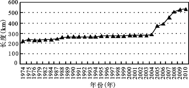
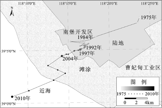
From 1970s, many projects of land reclamation from the sea were implemented in the northwest coast of Bohai Bay successively. Therefore this region becomes the biggest zone of artificial land reclamation from the sea in China at present. It is necessary to monitor and analyze these changes accurately and continuously. Using the annual MSS/TM/ETM images from 1974 to 2010 and based on comprehensive analysis of GIS and RS, the spatial variance and quantitative changes of land reclamation from the sea in the study area were obtained. During the past 36 years, the main land increased 901.7 km2 which mainly reclaimed from tidal flat and offshore. The coastline increased from 224.9 km in 1974 to 536.7 km in 2010 and the barycenter of total reclamation area transferred 26.3 km from northeast to southwest continuously. Then, 5 phases were divided based on the annual change of land reclamation and some results could be concluded as follow. 1) the increment of coastline length was positively correlated with annual reclamation area. 2) the aim of land reclamation from the sea experienced several development courses: “saltern-oriented” →“combining saltern and aquaculture”→“combining port and port-vicinity industry”. 3) Tianjin Port with its port-vicinity industry zones and Caofeidian Port with its port-vicinity industry zones became the center and sub-center of land reclamation from the sea respectively.
ZHU Gao-ru , XU Xue-gong . Annual Processes of Land Reclamation from the Sea Along the Northwest Coast of Bohai Bay During 1974 to 2010[J]. SCIENTIA GEOGRAPHICA SINICA, 2012 , 32(8) : 1006 -1012 . DOI: 10.13249/j.cnki.sgs.2012.08.1006
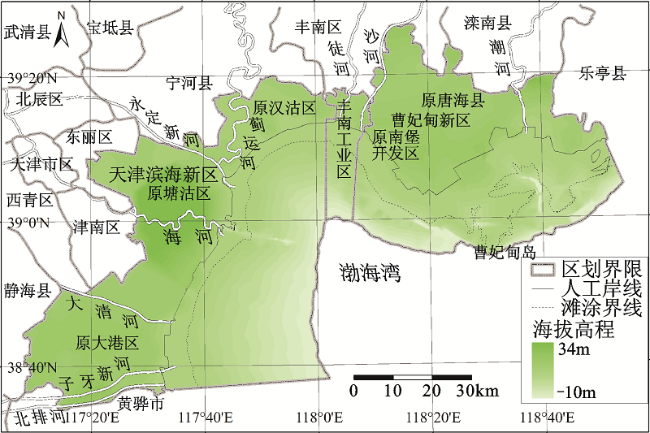
Fig. 1 Location of the study area图1 研究区位置 |
Table 1 Dataset of the study表1 研究所用数据集 |
| 大类 | 具体类型 | 数据描述 | 数据来源 | 备注 |
|---|---|---|---|---|
| 遥感 影像 | MSS | 1974-06-05, 1975-03-11, 1976-09-19, 1979-09-04, 1982-09-15 (1982-05-13) | ① 国际科学数据服务平台; ② 中国科学院对地观测中心 ③ 美国马里兰大学全球 土地覆盖研究部 | ① 缺少1977, 1978, 1980, 1981, 1983, 1985, 1986年影像;② “( )”内为拼接图幅的日期 |
| TM | 1984-09-10, 1987-03-27, 1988-09-21, 1989-08-23, 1990-08-10, 1991-09-30, 1992-07-30, 1993-06-15, 1994-09-06, 1995-05-04, 1996-05-22, 1997-05-25, 1998-09-01, 2004-10-03, 2005-09-04, 2006-07-21, 2007-09-10, 2008-09-02, 2009-08-30, 2010-08-17 | |||
| ETM | 1999-08-11, 2000-06-10, 2001-09-01, 2002-05-31, 2003-05-18, 2008-09-20 | |||
| 其他 数据 | DEM | 全国1:25万地形数据库j5003, j5004, j5007, j5008分幅 | 国家基础地理信息中心 | 1995年 |
| 海图 | 秦皇岛港至岐河口海图 | 中国人民解放军司令部 航海保证部 | 2004年 | |
| 行政区界 | 天津滨海新区、唐山曹妃甸新区、丰南工业区界 | 行政区划、规划图 |
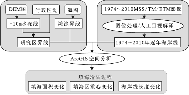
Fig.2 The study flow图2 研究流程 |
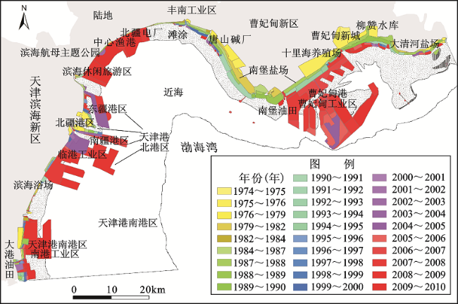
Fig.3 Courses of land reclamation from the sea in the study area during 1974 to 2010图3 研究区1974~2010年填海造陆进程 |
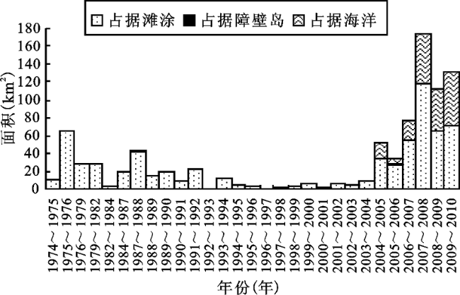
Fig. 4 Reclamation area and sources of each year图4 研究区填海面积及其来源变化 |
Fig.5 Yearly change of the coastline length of the study area图5 研究区海岸线长度变化 |
Fig. 6 Barycenter transfer of total reclamation area图6 研究区累积填海区重心转移 |
The authors have declared that no competing interests exist.
| [1] |
|
| [2] |
|
| [3] |
|
| [4] |
|
| [5] |
|
| [6] |
|
| [7] |
|
| [8] |
|
| [9] |
|
| [10] |
|
| [11] |
|
| [12] |
|
| [13] |
|
| [14] |
|
| [15] |
|
| [16] |
|
| [17] |
|
| [18] |
|
| [19] |
|
/
| 〈 |
|
〉 |