
A Preliminary View on the Estimation of Land Surface Temperature Under Cloud Cover from Thermal Remote Sensing Data
Received date: 2012-03-26
Request revised date: 2012-09-03
Online published: 2013-01-31
Copyright
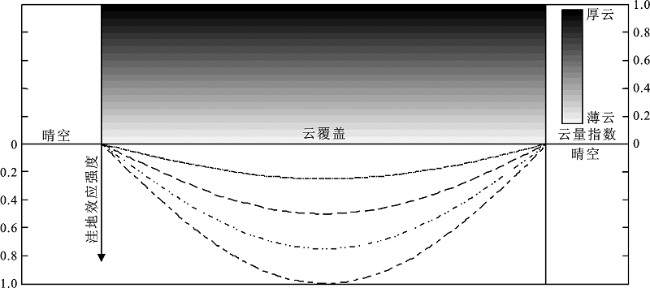
Land surface temperature (LST) is a very important parameter controlling the energy and water balance between atmosphere and land surface. Since it is difficult to obtain such information from ground-based measurements, it appears to be very attractive by using satellite thermal infrared measurements to estimate LST since it can be used for estimating surface temperature at global or local scale. Moreover, the estimation of LST by using satellite remote sensing data is feasible. Cloud cover is a major obstacle to thermal infrared remote sensing applications and remote sensing quantitative retrieval of land surface temperature. Furthermore, cloud frequently exists in most time and covers roughly half the surface of the Earth even if the sky is clear. This is the case especially in some regions of high latitudes in the north hemisphere, e.g. the tropics are covered by cloud for about 60% of the time. Therefore, the influence of clouds on LST deserves more discussion and how to estimate LST of pixels covered by cloud on thermal remotely sensed imagery is one of the cutting-edge research problems. In this article, based on the theory of surface energy balance (SEB), three methods, which are spatial interpretation adjustment method, the adjustment method by correlations between LST and Vegetation Indices (VIs) and improved surface energy balance method, have been put forward for the estimation of LST when the sky is cloudy. Moreover, the lowland effect of LST spatial distribution under cloud cover and the method for the calculation of its intensity (denoted as SE) were also discussed. Generally speaking, when SE equals to 1, it means that SE reaches its maximum due to thick cloud cover .While SE equals to 0, it means that there is no lowland effect in clear sky. SE is strongly affected by the cloud and surface conditions. That is to say, SE is influenced greatly by cloud properties such as the time it appears and lasts, its shape, thickness and height and surface characteristics. In normal conditions, SE reaches the highest at the center of cloud cover, and the closer to the cloud cover margin, the less it is. Numerical simulation of the relationship between the intensity factors of the lowland effect and the image gray value, which is based on the SEB, is the key to the practice of the three methods of LST estimation under cloudy conditions.
ZHOU Yi , QIN Zhi-hao , BAO Gang . A Preliminary View on the Estimation of Land Surface Temperature Under Cloud Cover from Thermal Remote Sensing Data[J]. SCIENTIA GEOGRAPHICA SINICA, 2013 , 33(3) : 329 -334 . DOI: 10.13249/j.cnki.sgs.2013.03.329
Fig.1 Relationship of neighboring pixels in surface energy balance (SEB)图1 热量平衡方程中两邻近像元关系 |
Fig.2 Relationship between cloud cover of homogeneous surface and lowland effect in daytime图2 同质地表白天云覆盖厚度与洼地效应强度对应关系 |
The authors have declared that no competing interests exist.
| [1] |
|
| [2] |
|
| [3] |
|
| [4] |
|
| [5] |
|
| [6] |
|
| [7] |
|
| [8] |
|
| [9] |
|
| [10] |
|
| [11] |
|
| [12] |
|
| [13] |
|
| [14] |
|
| [15] |
|
| [16] |
|
| [17] |
|
| [18] |
|
| [19] |
|
| [20] |
|
| [21] |
|
| [22] |
|
| [23] |
|
| [24] |
|
| [25] |
|
| [26] |
|
| [27] |
|
/
| 〈 |
|
〉 |
