
The Susceptibility Assessment of Landslide and Its Calibration of the Models Based on Three Different Models
Received date: 2013-03-29
Request revised date: 2013-06-10
Online published: 2013-08-16
Copyright
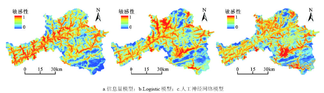
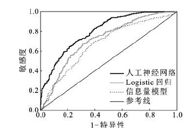
Landslide disaster restricts the sustainable development of human beings which would cause deaths and injuries, property damage and living environment ruins seriously. The regions should be divided into deferent types on the base of disaster risk when making macroeconomic policy of regional geological disaster. Thus, it is very necessary to make susceptibility assessment on zoning prone and risk of geological disasters in these regions firstly. When different assessment models are employed, the results are different. Furthermore, land types according to result of the susceptibility would results in difference in economy. Thus, it was more important to employ suitable model whose susceptibility assessment results were objective and realistic to the fact; however, there were few reports in this field in China yet. This study made assessments on the susceptibility of landslide disaster and evaluated the results. The employed susceptibility assessment models were information value, logistic regression and artificial neural network model. The relative relief, slope, aspect, river system, distance to fault, vegetation cover, formation lithology and road were chosen as factors. The results were showed as following. Firstly, the accuracy of classification influenced the social economic cost. Cohen’s Kappa factor method, precision evaluation method proposed by Sridevie Jadi and ROC curve method as the evaluation methods were used to evaluate the assessment results obtained from above models. The Kappa coefficients were 0.72, 0.69 and 0.55 by artificial neural network model, logistic regression method and information value model, respectively. The empirical probity (namely accuracy of prediction results) proposed by Sridevie Jadi of above 3 models was 87.48%, 74.26% and 69.54%, respectively. The AUC values were 0.805, 0.724 and 0.684, respectively. These evaluations proved that the assessment result obtained by artificial neural network model was more realistic to the fact. As a result, artificial neural network model performed the highest level of accuracy in the 3 models. Secondly, there could be one zone and 3 areas according to the landslide assessment results in Ningqiang County. They were: the zone of two sides of Mianxian County-Yang pingguan-Jin shanshi fault, volcanic area of Da′an-Miaoba-Gongjiahe-Daijiaba, shale, siltstone and slate area of Tiesuoguan-Hujiaba, phyllite, slate and sandstone area of Anlehe-Guangping, respectively. The area of high-susceptibility area was 1 300.85 km2 which accounted for 39.96% of the county area. Landslide in this area was well developed which was affected by Jinshansi-Yangpingguan-Mianxian fault obviously. The area of medium and low susceptibility was 1 227.34 km2 and 727.02 km2 which accounted for 37.7% and 22.33% respectively.
Key words: landslide; susceptibility assessment; calibration of the models
QIU Hai-jun , CAO Ming-ming , LIU Wen , WANG Yan-min , HAO Jun-qing , HU Sheng . The Susceptibility Assessment of Landslide and Its Calibration of the Models Based on Three Different Models[J]. SCIENTIA GEOGRAPHICA SINICA, 2014 , 34(1) : 110 -115 . DOI: 10.13249/j.cnki.sgs.2014.01.110
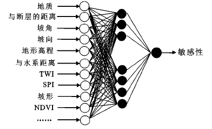
Fig.1 Structure diagram of neural network图1 神经网络结构 |
Fig.2 Sensitivity of evaluation results of different models图2 不同模型的敏感性评价结果 |
Table 1 Contingency table of landslide model assessment表1 滑坡模型评价列联表 |
| 观测结果 | 预测 | ||
|---|---|---|---|
| 分类0(-)稳定 | 分类1(+)不稳定 | ||
| 分类0(-)稳定 | (-|-)真阴性,tn | (+|-)假阳性, fp,错误类型1 | N |
| 分类1(+)不稳定 | (-|+)假阴性, fn,错误类型II | (+|+)真阳性,tp | P |
| NP | PP | T | |
Fig.3 ROC curves of landslide susceptibility assessment图3 滑坡评价的ROC曲线 |
The authors have declared that no competing interests exist.
| [1] |
|
| [2] |
|
| [3] |
|
| [4] |
|
| [5] |
|
| [6] |
|
| [7] |
|
| [8] |
|
| [9] |
|
| [10] |
|
| [11] |
|
| [12] |
|
| [13] |
|
| [14] |
|
| [15] |
|
| [16] |
|
| [17] |
|
| [18] |
|
| [19] |
|
/
| 〈 |
|
〉 |