
Leveraging remote sensing-based AI to explore evolution of traditional settlement morphology on a large geographical scale
Received date: 2024-01-01
Revised date: 2024-05-31
Online published: 2025-06-24
Supported by
National Natural Science Foundation of China(42371206)
Copyright
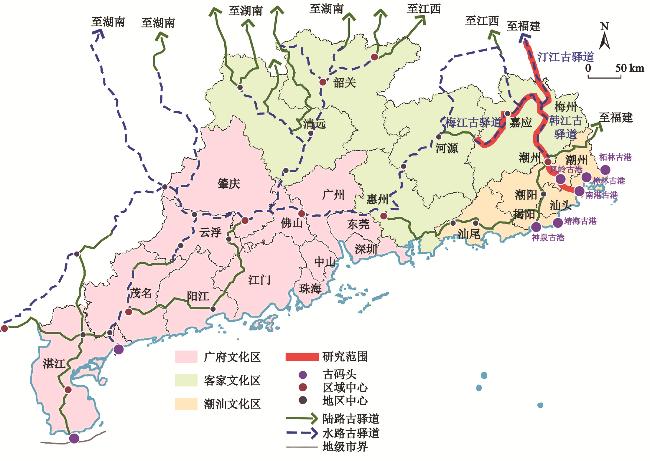
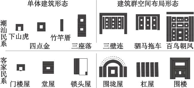
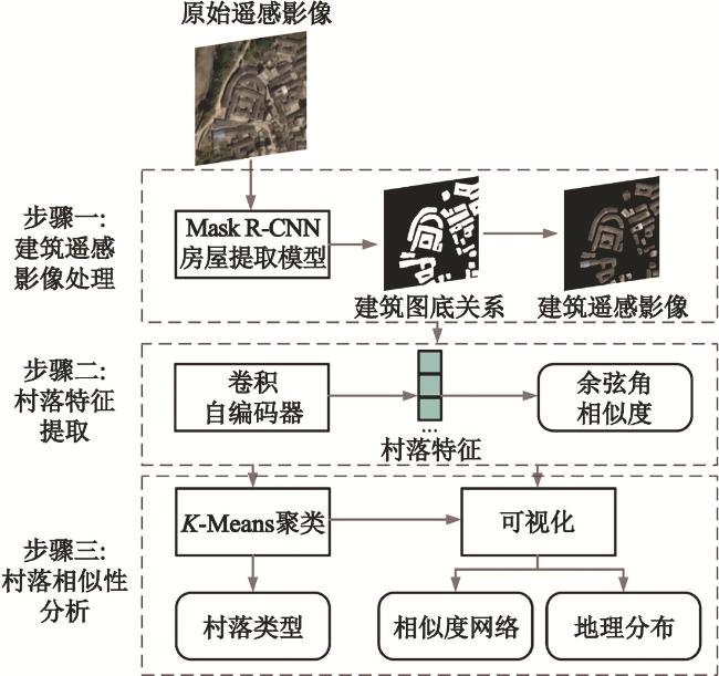
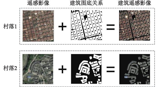
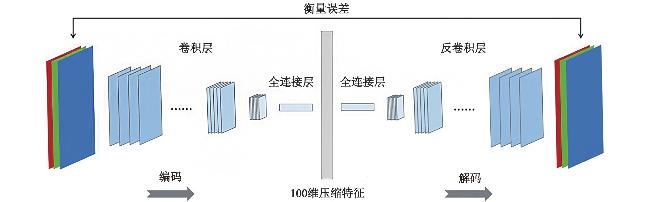
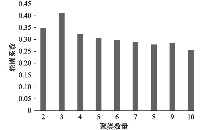
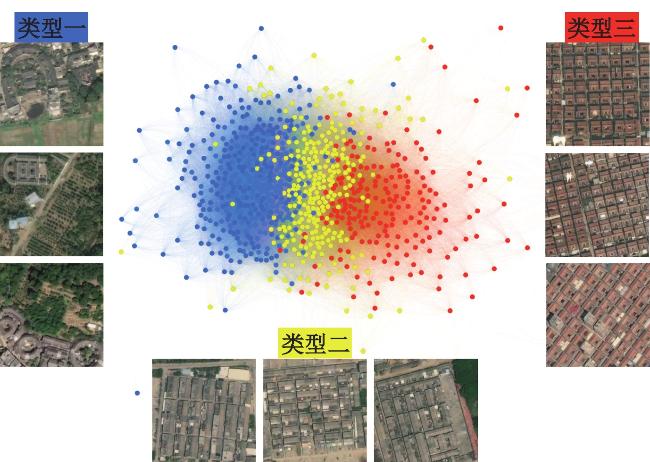
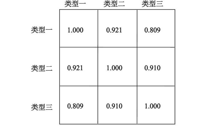
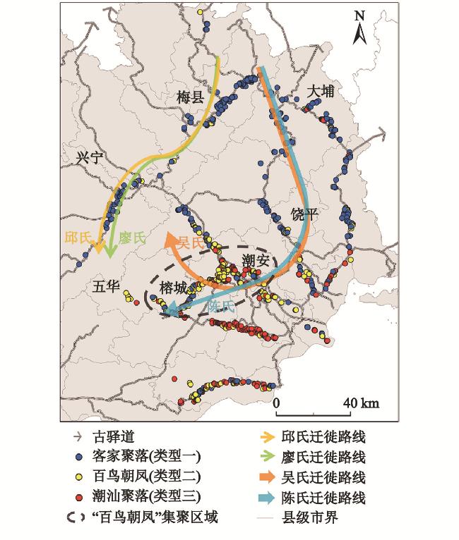
Folk migration is a historical and social phenomenon worthy of study. However, most of folk migration in Chinese history does not have detailed written records and accurate data. Folk migration has left many traditional villages, whose settlement forms contain information on the “genes” of their folk groups and their evolution. Thus, traditional villages can be used as side evidence to reveal historical migrations. However, there is still a lack of means to study traditional settlement morphology on a large geographic scale, which makes it difficult to obtain overall universal patterns. Currently, artificial intelligence techniques for satellite remote sensing images show strong potential in earth observation. Applying these techniques is a promising way to restore the wholeness of traditional settlement patterns. In this study, we propose a remote sensing-based AI method to explore the evolution of traditional settlement morphology on a large geographic scale. In detail, a self-supervised deep learning model, called convolutional autoencoder, is applied to automatically extracting the folk prototype information of settlement forms from building footprint data and remote sensing images. The extracted folk prototype information is represented as feature vector format, which then is input to KMeans clustering algorithm to categorize the folk prototypes. In addition, cosine similarity is used to calculate the similarity space of the selected villages, in order to discover the topological relationship between the folk prototypes. Hanjiang River Basin area is taken as the study area and the traditional villages of Hakka and Teochew folk groups are the research objects of this study. The result of the convolutional autoencoder is combined with historical records of folk migration, in order to restore the process of the evolution of the settlement morphology. The results show that the prototypes of Hakka and Teochew villages exist in the basin of the Hanjiang River, and show a pattern of morphological gradual change along the migration path. From the data-driven perspective and historical records’ perspective, this article demonstrates that the Hakka and Teochew settlement prototypes derived from the migration-driven cultural fusion process have created a transitional settlement form “Hundred Birds Toward the Phoenix”, which combines the characteristics of Hakka and Teochew prototypes, and thus complements the existing knowledge of traditional settlement morphology. In detail, from the data-driven perspective, Type 2 is recognized as the transitional type between the Type 1 and Type 3 in the feature similarity space. Also, the villages of Type 2 are mainly located between the villages of Type 1 and Type 3 in the geographic space. From the historical records’ perspective, the villages of Type 1 and Type 3 are recognized as Hakka and Teochew villages. And the villages of Type 2 are identified as the settlement form of “Hundred Birds Toward the Phoenix”. In summary, the settlement form of “Hundred Birds Toward the Phoenix” is recognized as the transitional form between the Hakka and Teochew settlement prototypes. Using traditional villages as a medium, this article provides a feasible tool for exploring the morphological evolution of folk settlements on a large scale without manual survey and labelling. Currently, the method proposed in this article automates feature extraction, but the input remote sensing images of traditional villages still need to be manually selected by the researcher. In order to further improve the automation of traditional settlement pattern recognition, in the future, this study will combine other artificial intelligence tools to achieve automatic selection of traditional village remote sensing images and combine them with the method in this article to form a set of automated processes, which will further break through the limitations of traditional surveys, and bring more data for the study of historical population migration.
Chen Dongsheng , Li Junjun , Xu Weipan , Li Xun . Leveraging remote sensing-based AI to explore evolution of traditional settlement morphology on a large geographical scale[J]. GEOGRAPHICAL SCIENCE, 2025 , 45(6) : 1157 -1167 . DOI: 10.13249/j.cnki.sgs.20240001
| [1] |
葛剑雄. 中国人口发展史[M]. 成都: 四川人民出版社, 2020: 12-17
Ge Jianxiong. History of population development in China. Chengdu: Sichuan People’s Publishing House, 2020: 12-17.
|
| [2] |
谭其骧. 中国移民史要[M]. 上海: 复旦大学出版社, 2021
Tan Qixiang. The history of Chinese immigration. Shanghai: Fudan University Press, 2021.
|
| [3] |
葛剑雄. 简明中国移民史[M]. 福州: 福建人民出版社, 1993
Ge Jianxiong. The history of Chinese migration. Fuzhou: Fujian People’s Publishing House, 1993.
|
| [4] |
葛剑雄. 研究中国移民史的基本方法和手段[J]. 浙江社会科学, 1997(4): 82-91
Ge Jianxiong. The basic methodology and approach in China migration history research. Zhejiang Social Sciences, 1997(4): 82-91
|
| [5] |
杨晓俊, 方传珊, 王益益. 传统村落景观基因信息链与自动识别模型构建——以陕西省为例[J]. 地理研究, 2019, 38(6):1378-1388.
Yang Xiaojun, Fang Chuanshan, Wang Yiyi. Construction of gene information chain and automatic identification model of traditional village landscape: Taking Shaanxi Province as an example. Geographical Research, 2019, 38(6):1378-1388.
|
| [6] |
刘沛林, 刘春腊, 邓运员, 等. 中国传统聚落景观区划及景观基因识别要素研究[J]. 地理学报, 2010, 65(12):1496-1506.
Liu Peilin, Liu Chunla, Deng Yunyuan et al. Landscape division of traditional settlement and effect elements of landscape gene in China. Acta Geographica Sinica, 2010, 65(12):1496-1506.
|
| [7] |
曾艳, 肖大威, 陶金. 粤东梅州地区围屋类型文化地理研究[J]. 建筑学报, 2015(S1): 118-123
Zeng Yan, Xiao Dawei, Tao Jin. Cultural geography of topology of Yuet Tung Meizhou enclosed house. Architectural Journal. 2015(S1): 118-123.
|
| [8] |
陈星灿, 刘莉, 李润权, 等. 中国文明腹地的社会复杂化进程——伊洛河地区的聚落形态研究[J]. 考古学报, 2003(2): 161-218
Chen Xingcan, Liu Li, Li Runquan et al. Development of social complexity in the central China: Research into the settlement pattern in the Yiluo River valley. Acta Archaeologica Sinica, 2003(2): 161-218.
|
| [9] |
陆元鼎. 南方民系民居的形成发展与特征[M]. 广州: 华南理工大学出版社, 2019: 106-110
Lu Yuanding. The formation, development and characteristics of southern ethnic dwellings. Guangzhou: South China University of Technology Press, 2019: 106-110.
|
| [10] |
杨希, 马航, 张力智, 等. 迁徙中的承袭、交融与分异——广东客家建筑与聚落形态时空发展解析[J]. 地理研究, 2021, 40(4):958-976.
Yang Xi, Ma Hang, Zhang Lizhi et al. Inheritance, fusion, and variation during migration: An analysis of spatio-temporal morphological development of traditional Guangdong Hakka architecture and settlements. Geographical Research, 2021, 40(4):958-976.
|
| [11] |
曾艳. 广东传统聚落及其民居类型文化地理研究[D]. 广州: 华南理工大学, 2016
Zeng Yan. Cultural geographic research on traditional settlement and housing types in Guangdong. Guangzhou: South China University of Technology, 2016.
|
| [12] |
李婧, 杨定海, 肖大威. 海南岛传统聚落及民居文化景观区划定量方法研究[J]. 小城镇建设, 2020, 38(5):39-48.
Li Jing, Yang Dinghai, Xiao Dawei. A quantitative study on the cultural landscape division of the traditional settlements and vernacular dwellings in Hainan Island. Development of Small Cities & Towns, 2020, 38(5):39-48.
|
| [13] |
孙莹, 王玉顺, 肖大威, 等. 基于GIS的梅州客家传统村落空间分布演变研究[J]. 经济地理, 2016, 36(10): 193-200
Sun Ying, Wang Yushun, Xiao Dawei et al. The spatial distribution and evolution of Hakka traditional villages on GIS in Meizhou area. Economic Geography, 2016, 36(10): 193-200.
|
| [14] |
Jean N, Burke M, Xie M et al. Combining satellite imagery and machine learning to predict poverty. Science, 2016, 353(6301):790-794.
|
| [15] |
Huang Bo, Zhao Bei, Song Yimeng. Urban land-use mapping using a deep convolutional neural network with high spatial resolution multispectral remote sensing imagery. Remote Sensing of Environment, 2018, 214:73-86.
|
| [16] |
Bhaduri B, Bright E, Coleman P et al. LandScan USA: A high-resolution geospatial and temporal modeling approach for population distribution and dynamics. GeoJournal, 2007, 69(1-2):103-117.
|
| [17] |
Gavankar N L, Ghosh S K. Automatic building footprint extraction from high-resolution satellite image using mathematical morphology. European Journal of Remote Sensing, 2018, 51(1):182-193.
|
| [18] |
李郇, 许伟攀, 黄耀福, 等. 基于遥感解译的中国农房空间分布特征分析[J]. 地理学报, 2022, 77(4):835-851.
Li Xun, Xu Weipan, Huang Yaofu et al. Spatial distribution of rural building in China: Remote sensing interpretation and density analysis. Acta Geographica Sinica, 2022, 77(4):835-851.
|
| [19] |
李郇, 谷宇, 邓伟环, 等. 可计算乡村的技术框架[J]. 华南地理学报, 2023, 1(1): 22-35
Li Xun, Gu Yu, Deng Weihuan et al. The technical framework of computable village. South China Geographical Journal, 2023, 1(1): 22-35.
|
| [20] |
杨帆, 沈来信, 王雪飞. 基于卫星图像的古民居识别算法[J]. 计算机应用与软件, 2016, 33(9):154-158.
Yang Fan, Shen Laixin, Wang Xuefei. Recognition algorithm of ancient dwellings based on satellite images. Computer Applications and Software, 2016, 33(9):154-158.
|
| [21] |
覃巧华, 肖大威, 骆明楠, 等. 基于卷积神经网络的传统村落图景分类研究[J]. 城市规划, 2020, 44(7):52-58.
Qin Qiaohua, Xiao Dawei, Luo Mingnan et al. A study on the classification of traditional village images based on convolutional neural network. City Planning Review, 2020, 44(7):52-58.
|
| [22] |
刘文鹏. 清代驿站考[M]. 北京: 人民出版社, 2017
Liu Wenpeng. Qing Dynasty post researches. Beijing: People’s Publishing House, 2017.
|
| [23] |
罗香林. 客家研究导论(外一种: 客家源流考)[M]. 广州: 广东人民出版社, 2018
Luo Xianglin. An introduction to the origins of Hakka. Guangzhou: Guangdong People Press, 2018.
|
| [24] |
黄挺. 潮客关系简论——以潮汕地区为例[J]. 韩山师范学院学报(社会科学版), 2005(1): 1-7
Huang Ting. On the relationship of Chaozhou tribe and Kejia tribe. Journal of Hanshan Teachers College. 2005(1): 1-7.
|
| [25] |
Moosavi V. Urban morphology meets deep learning: Exploring urban forms in one million cities, towns, and villages across the planet[J]. Machine Learning and the City: Applications in Architecture and Urban Design, 2022, 379-392.
|
| [26] |
Krishna K, Murty M N. Genetic K-means algorithm. IEEE Transactions on Systems, Man, and Cybernetics, Part B (Cybernetics), 1999, 29(3):433-439.
|
| [27] |
Hu Yifan. Efficient, high-quality force-directed graph drawing. Mathematica Journal, 2005, 10(1):37-71.
|
| [28] |
陆琦. 广东民居[M]. 北京: 中国建筑工业出版社, 2008
Lu Qi. The Guangdong vernacular housing. Beijing: China Architecture and Building Press, 2008.
|
/
| 〈 |
|
〉 |