
Impact of production-living-ecological spatial structure on flood hazard in the Xitiaoxi River Basin
Received date: 2024-05-20
Revised date: 2024-10-10
Online published: 2025-06-24
Supported by
The Fifth Phase of "Project 333" Scientific Research Support Program of Jiangsu Province(BRA2019268)
Copyright
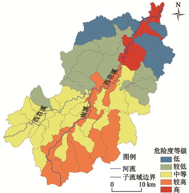
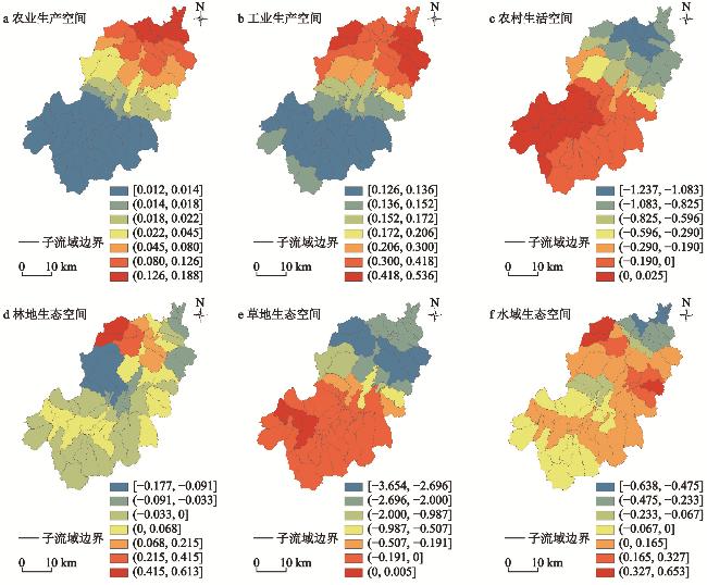
Based on land use data, meteorological data, hydrological data, soil data, and DEM data, the area change rate of production-living-ecological space was used to reveal the structural change characteristics of the Xitiaoxi River Basin from 1990 to 2018, the SWAT model and AHP-entropy weight method were comprehensively utilized to assess the flood hazards, and geographically weighted regression model was used to explore the impact of production-living-ecological space structure on the hazard of regional flood hazards. The results show that: 1) The structure of the production-living-ecological space has significant changes in the Xitiaoxi River Basin, with considerable changes in agricultural and industrial production spaces, while rural living space and other ecological space had experienced smaller changes, and the directions of changes in various spaces were diverse. 2) The spatial distribution of flood hazard levels in the study area was significantly different, with high/relatively high hazard levels mainly distributed in the southeast of the upstream basin and some sub-basins close to the river downstream. 3) The structure of the production-living-ecological space in the study area had a significant impact on flood hazards. In general, the area change rate of agricultural and industrial production space had significant positive impact on the change rate of flood hazards in the Xitiaoxi River Basin, while the area change rate of rural living space and grassland ecological space had significant negative impact on the change rate of flood hazards. The area change rates of forest and water ecological spaces had varying impact on the change rate of flood hazards. There were obvious spatial differences in the effects of various spaces on flood hazards.
Kong Dongyan , Chen Huiguang , Wu Kongsen . Impact of production-living-ecological spatial structure on flood hazard in the Xitiaoxi River Basin[J]. GEOGRAPHICAL SCIENCE, 2025 , 45(6) : 1246 -1258 . DOI: 10.13249/j.cnki.sgs.20240478
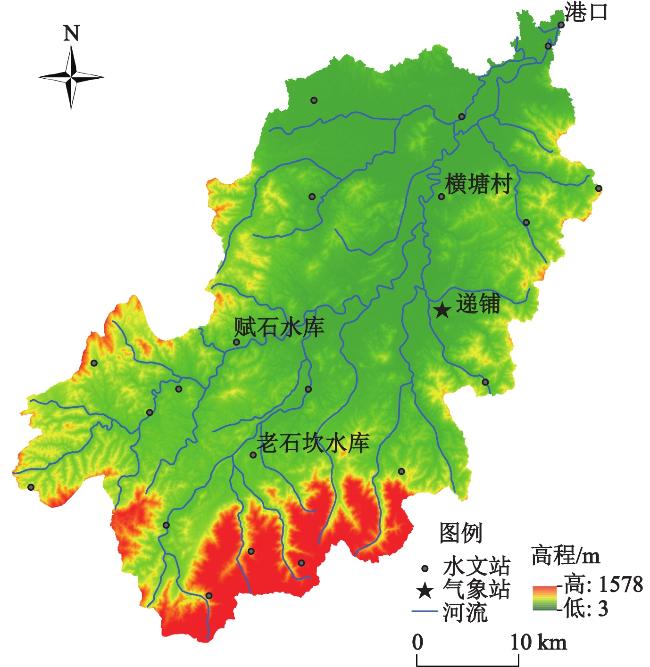
表1 洪涝灾害危险度评估指标及权重Table 1 Indicators and weights of flood hazard assessment |
| 评估指标 | 单位 | 指标解释与说明 | 权重 | ||
| 层次分析法 | 熵权法 | AHP-熵权法 | |||
| 年平均暴雨量 | mm | 24 h累计降水量在50 mm以上降水量总和的平均值 | 0.210 | 0.127 | 0.176 |
| 年平均暴雨日数 | d | 24 h累计降水量在50 mm以上降水日数的平均值 | 0.240 | 0.112 | 0.188 |
| 径流量 | m3/s | SWAT模型模拟的径流量 | 0.550 | 0.761 | 0.636 |
表2 SWAT模型月径流模拟率定和验证结果Table 2 Calibration and validation results of SWAT model for monthly runoff |
| 港口 | 横塘村 | 赋石水库 | 老石坎水库 | ||||||||
| 率定期 | 验证期 | 率定期 | 验证期 | 率定期 | 验证期 | 率定期 | 验证期 | ||||
| R2 | 0.830 | 0.710 | 0.790 | 0.740 | 0.720 | 0.710 | 0.680 | 0.630 | |||
| NSE | 0.800 | 0.690 | 0.780 | 0.730 | 0.710 | 0.670 | 0.630 | 0.580 | |||
| PBIAS/% | -12.900 | 5.700 | -6.100 | -2.300 | -2.600 | 11.600 | 6.700 | 16.800 | |||
表3 OLS线性回归模型估计结果Table 3 Estimation results of OLS linear regression model |
| 非标准化系数 | 标准系数 | t | Sig | 共线性统计 | ||||
| B | 标准错误 | β | 容许 | VIF | ||||
| 常量 | 0.603 | 0.128 | - | 4.715 | 0.000 | - | - | |
| 农业生产空间 | 0.038 | 0.017 | 0.115 | 2.156 | 0.032 | 0.829 | 1.206 | |
| 工业生产空间 | 0.408 | 0.048 | 0.519 | 8.562 | 0.000 | 0.638 | 1.566 | |
| 农村生活空间 | -0.248 | 0.142 | -0.087 | -1.745 | 0.082 | 0.955 | 1.047 | |
| 林地生态空间 | -0.222 | 0.087 | -0.279 | -2.562 | 0.011 | 0.198 | 5.047 | |
| 草地生态空间 | -0.321 | 0.135 | -0.147 | -2.382 | 0.018 | 0.616 | 1.623 | |
| 水域生态空间 | -0.232 | 0.103 | -0.214 | -2.255 | 0.025 | 0.262 | 3.823 | |
表4 GWR模型估计结果Table 4 Estimation results of GWR model |
| 平均值 | 最小值 | 上四分位 | 中位数 | 下四分位 | 最大值 | |
| 农业生产空间 | 0.013 | -0.002 | 0.003 | 0.007 | 0.024 | 0.044 |
| 工业生产空间 | 0.157 | 0.060 | 0.071 | 0.082 | 0.249 | 0.398 |
| 农村生活空间 | -0.184 | -0.471 | -0.343 | -0.102 | -0.066 | 0.005 |
| 林地生态空间 | 0.016 | -0.101 | -0.056 | 0.005 | 0.035 | 0.361 |
| 草地生态空间 | -0.052 | -0.414 | -0.094 | -0.059 | -0.015 | 0.289 |
| 水域生态空间 | -0.014 | -0.253 | -0.072 | -0.023 | 0.029 | 0.273 |
| [1] |
许武成. 灾害地理学[M]. 北京: 科学出版社, 2015
Xu Wucheng. Hazard Geography. Beijing: Science Press, 2015.
|
| [2] |
尚志海, 丘世钧. 当代全球变化下城市洪涝灾害的动力机制[J]. 自然灾害学报, 2009, 18(1):100-105.
Shang Zhihai, Qiu Shijun. Dynamic mechanism analysis of urban flood and water logging under contemporary global change. Journal of Natural Disasters, 2009, 18(1):100-105.
|
| [3] |
袁艺, 史培军, 刘颖慧, 等. 土地利用变化对城市洪涝灾害的影响[J]. 自然灾害学报, 2003, 12(3):6-13.
Yuan Yi, Shi Peijun, Liu Yinghui et al. Impact of land use change on urban flood disaster. Journal of Natural Disasters, 2003, 12(3):6-13.
|
| [4] |
Bobrowsky P T. Encyclopedia of natural hazards[M]. Dordrecht: Springer, 2013.
|
| [5] |
Niehoff D, Fritsch U, Bronstert A. Land-use impacts on storm-runoff generation: Scenarios of land-use change and simulation of hydrological response in a meso-scale catchment in SW-Germany. Journal of Hydrology, 2002, 267(1-2):80-93.
|
| [6] |
Camorani G, Castellarin A, Brath A. Effects of land-use changes on the hydrologic response of reclamation systems. Physics and Chemistry of the Earth, Parts A /B /C, 2005, 30(8-10):561-574.
|
| [7] |
Mather A S. Land use[M]. London: Longman Group U. K. Limited, 1986.
|
| [8] |
Wisner B, Blaikie P, Cannon T et al. At risk: Natural hazards, people’s vulnerability and disasters[M]. London: Routledge, 2004.
|
| [9] |
彭建, 魏海, 武文欢, 等. 基于土地利用变化情景的城市暴雨洪涝灾害风险评估——以深圳市茅洲河流域为例[J]. 生态学报, 2018, 38(11):3741-3755.
Peng Jian, Wei Hai, Wu Wenhuan et al. Storm flood disaster risk assessment in urban area based on the simulation of land use scenarios: A case of Maozhou Watershed in Shenzhen City. Acta Ecologica Sinica, 2018, 38(11):3741-3755.
|
| [10] |
雷超桂, 许有鹏, 张倩玉, 等. 流域土地利用变化对不同重现期洪水的影响——以奉化江皎口水库流域为例[J]. 生态学报, 2016, 36(16):5017-5026.
Lei Chaogui, Xu Youpeng, Zhang Qianyu et al. Impacts of land-use change on flood process and frequency of various return periods: A case study of Jiaokou Reservoir watershed in Fenghua River. Acta Ecologica Sinica, 2016, 36(16):5017-5026.
|
| [11] |
Yang M, Yusoff W F M, Mohamed M F et al. Flood economic vulnerability and risk assessment at the urban mesoscale based on land use: A case study in Changsha, China. Journal of Environmental Management, 2024, 351:119798
|
| [12] |
Cheng H, Lin B Q, Ying S R et al. Different responses of event-based flood to typhoon and non-typhoon rainstorms under land use change in Xixi Basin of southeastern China. Catena, 2024, 234:107562
|
| [13] |
Wang J Y, Hu C H, Ma B Y et al. Rapid urbanization impact on the hydrological processes in Zhengzhou, China. Water, 2020, 12(7):1870
|
| [14] |
苏伟忠, 汝静静, 杨桂山. 流域尺度土地利用调蓄视角的雨洪管理探析[J]. 地理学报, 2019, 74(5):948-961.
Su Weizhong, Ru Jingjing, Yang Guishan. Modelling stormwater management based on infiltration capacity of land use in the watershed scale. Acta Geographica Sinica, 2019, 74(5):948-961.
|
| [15] |
刘贤赵, 谭春英, 宋孝玉, 等. 黄土高原沟壑区典型小流域土地利用变化对产水量的影响——以陕西省长武王东沟流域为例[J]. 中国生态农业学报, 2005, 13(4):99-102.
Liu Xianzhao, Tan Chunying, Song Xiaoyu et al. Impact of land use change on the water yield of typical small watershed in gully region at loess plateau—A case study from Wangdonggou watershed in Changwu Shaanxi Province. Chinese Journal of Eco-Agriculture, 2005, 13(4):99-102.
|
| [16] |
Hamers E M, Maier H R, Zecchin A C et al. Framework for considering the interactions between climate change, socio-economic development and land use planning in the assessment of future flood risk. Environmental Modelling & Software, 2024, 171:105886
|
| [17] |
Zope P E, Eldho T I, Jothiprakash V. Impacts of land use-land cover change and urbanization on flooding: A case study of Oshiwara River Basin in Mumbai, India. Catena, 2016, 145:142-154.
|
| [18] |
Blum A G, Ferraro P J, Archfield S A et al. Causal effect of impervious cover on annual flood magnitude for the United States. Geophysical Research Letters, 2020, 47(5):e2019GL086480
|
| [19] |
Schilling K E, Gassman P W, Kling C L et al. The potential for agricultural land use change to reduce flood risk in a large watershed. Hydrological Processes, 2014, 28(8):3314-3325.
|
| [20] |
Butler W H, Deyle R E, Mutnansky C. Low-regrets incrementalism: Land use planning adaptation to accelerating sea level rise in Floridas coastal communities. Journal of Planning Education & Research, 2016, 36(3):319-332.
|
| [21] |
Ku C A. Evaluating the effects of land-use strategies on future flood risk reduction in urban areas. Cities, 2024, 150:104989
|
| [22] |
周可婧, 焦胜, 韩宗伟. 沿海城市洪涝高风险区土地利用管控——纽约市的经验与启示[J]. 国际城市规划, 2022, 37(5):121-130.
Zhou Kejing, Jiao Sheng, Han Zongwei. Land-use management within high-risk floodplain area in coastal cities: The experience and enlightenment from New York City. Urban Planning International, 2022, 37(5):121-130.
|
| [23] |
马海涛. 科学认知“国土空间”[J]. 科学, 2015, 67(5): 42-44
Ma Haitao. Understanding land space in a scientific way. Science, 2015, 67(5): 42-44+4.
|
| [24] |
万将军, 邓伟, 张少尧, 等. 喀斯特山区国土空间类型划分及其变化特征研究[J]. 生态经济, 2018, 34(10):184-190.
Wan Jiangjun, Deng Wei, Zhang Shaoyao et al. Land space type classification and variation study on its change in karst mountain county. Ecological Economy, 2018, 34(10):184-190.
|
| [25] |
孔冬艳, 陈会广, 吴孔森. 中国“三生空间”演变特征、生态环境效应及其影响因素[J]. 自然资源学报, 2021, 36(5):1116-1135.
Kong Dongyan, Chen Huiguang, Wu Kongsen. The evolution of “production-living-ecological” space, eco-environmental effects and its influencing factors in China. Journal of Natural Resources, 2021, 36(5):1116-1135.
|
| [26] |
杨清可, 段学军, 王磊, 等. 基于“三生空间”的土地利用转型与生态环境效应——以长江三角洲核心区为例[J]. 地理科学, 2018, 38(1):97-106.
Yang Qingke, Duan Xuejun, Wang Lei et al. Land use transformation based on ecological-production-living spaces and associated eco-environment effects: A case study in the Yangtze River Delta. Scientia Geographica Sinica, 2018, 38(1):97-106.
|
| [27] |
肖军仓, 周文银, 罗定贵, 等. 非点源污染模型-SWAT用户应用指南[M]. 北京: 地质出版社, 2010
Xiao Juncang, Zhou Wenyin, Luo Dinggui et al. Non-point source pollution model-SWAT user application guide. Beijing: Geological Publishing House, 2010.
|
| [28] |
于文金, 阎永刚, 邹欣庆. 太湖流域暴雨时空特征研究[J]. 自然资源学报, 2012, 27(5):766-777.
Yu Wenjin, Yan Yonggang, Zou Xinqing. Study on spatial and temporal characteristics of rainstorm in Taihu Lake Basin. Journal of Natural Resources, 2012, 27(5):766-777.
|
| [29] |
石涛, 谢五三, 张丽, 等. 暴雨洪涝风险评估的GIS和空间化应用——以芜湖市为例[J]. 自然灾害学报, 2015, 24(5):169-176.
Shi Tao, Xie Wusan, Zhang Li et al. Application of GIS and spatialization of rainstorm and flood risk assessment—A case study of Wuhu City. Journal of Natural Disasters, 2015, 24(5):169-176.
|
| [30] |
刘媛媛, 王绍强, 王小博, 等. 基于AHP_熵权法的孟印缅地区洪水灾害风险评估[J]. 地理研究, 2020, 39(8):1892-1906.
Liu Yuanyuan, Wang Shaoqiang, Wang Xiaobo et al. Flood risk assessment in Bangladesh, India and Myanmar based on the AHP weight method and entropy weight method. Geographical Research, 2020, 39(8):1892-1906.
|
| [31] |
郑德凤, 刘晓星, 王燕燕, 等. 基于三维生态足迹的中国自然资本利用时空演变及驱动力分析[J]. 地理科学进展, 2018, 37(10):1328-1339.
Zheng Defeng, Liu Xiaoxing, Wang Yanyan et al. Spatiotemporal evolution and driving forces of natural capital utilization in China based on three-dimensional ecological footprint. Progress in Geography, 2018, 37(10):1328-1339.
|
| [32] |
孔冬艳. 国土空间格局的洪涝灾害风险响应与管控研究——以太湖西苕溪流域为例[D]. 南京: 南京农业大学, 2022
Kong Dongyan. The flood disaster risk response, management and control of territorial spatial pattern: A case study of Xitiaoxi Watershed of Taihu Basin. Nanjing: Nanjing Agricultural University, 2022.
|
| [33] |
Zhang H, Ma W C, Wan X R. Rapid urbanization and implications for flood risk management in hinterland of the Pearl River Delta, China: The Foshan study. Sensors, 2008, 8(4):2223-2239.
|
| [34] |
陈莹, 尹义星, 陈兴伟. 19世纪末以来中国洪涝灾害变化及影响因素研究[J]. 自然资源学报, 2011, 26(12):2110-2120.
Chen Ying, Yin Yixing, Chen Xingwei. Change of flood disasters in China since the 1880s and some possible causes. Journal of Natural Resources, 2011, 26(12):2110-2120.
|
/
| 〈 |
|
〉 |
