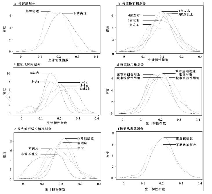
This article adopts a mixed quantitative and qualitative research method to explore the changes in the livelihood resilience of landless farmers in the urban fringe areas of economically developed regions. Shangcheng District and Qiantang District of Hangzhou were selected as the case areas. In the quantitative research part, an evaluation index system of livelihood resilience is constructed from three aspects: buffering ability, self-organizing ability and learning ability. Then the principal component analysis method was used to measure the livelihood resilience of land-lost farmers in the urban fringe area, and the differences between groups were compared through the kernel density map. The qualitative research part summarizes the path and reasons for the change of livelihood resilience through follow-up visits and observations of some land-lost farmers. The results show that: 1) The livelihood resilience index of land-lost farmers in the case area is generally low, and the buffering capacity, self-organization ability, and learning ability decline in turn; 2) The level of livelihood resilience is related to the location from the city center, the area of land acquisition, the use of land acquisition, and the time of land acquisition. However, it is not a simple linear relationship; 3) The changes in the livelihoods of land-lost farmers, affected by individual differences and external factors, will follow the trajectory of “external disturbances -buffer recovery-path alienation-involution leveling”.
In the cities with different spatial structures, the impacts of subways on the characteristics and accessibility of traditional public transport systems are quite different. Taking Shenyang and Dalian as examples, this study discusses the impacts on the characteristics and accessibility of public transport systems in cities with different spatial structures which occur when subways open and analyzes the reasons for the differences of impacts. The results show that: 1) The opening of subways has positive impacts on the characteristics and accessibility of the public transport systems in Shenyang and Dalian, the degree of the impacts spreads out and gradually decreases along the subway lines. 2) The impacts of the subways opening on the characteristics and accessibility of the public transport system in Dalian are more significant, and the impacts of subways themselves are more significant in Shenyang. The gap of the evaluation results of public transport systems characteristics and accessibility between the two cities increases after the subways open. 3) With the opening of subways, the agglomeration effect of the cluster center of the public transport system in the single-center circle cities is further enhanced, and the regional differences are enlarged, while the development of public transport system in the multi-center group cities tends to be more balanced.
Participatory community planning is an important way to solve community development problems. Existing researches mostly focus on the mode and procedure of participatory community planning, but pay insufficient attention to the content and mechanism of participatory community planning affecting social-spatial of community. Based on the theory of spatial production and participatory planning, this paper constructs an analytical framework of the impact of participatory community planning on social-spatial of community. Taking the collaborative workshop of Shenjing village in Guangzhou as an example, this paper discusses the content and mechanism of the impact of participatory community planning on social-spatial of community. The results show that: 1) Participatory community planning affects residents’ participation ability, the publicity of public space and public social life. Among them, residents’ participation ability has been improved in three aspects: cognition, interaction and behavior. The publicity of public space has been reconstructed in function, accessibility and interactivity. Public social life has been integrated in social relations and living space. 2) Participatory community planning achieves the accumulation of social spatial effects on communities by establishing a long-term mechanism of public participation and an action loop based on ‘communication-consensus-action’. In the future, it is necessary to further explain the relationship among intrapersonal, interactional and behavioral ability, and verify the effectiveness of the analytical framework through different types of case studies.
In order to analyze the relationship between passengers’ travel demand of online car-hailing and urban built environment, this paper proposes a network kernel density estimation method based on network distance search to identify the pick-up hot spots of online car-hailing. The network kernel density estimation considers the difference of travelers’ pick-up behavior between the road sections and intersections, which reflects the spatial distribution heterogeneity of online car-hailing demand. The regression model of geographically weighted regression model (GWR) is set up, taking the amount of points of interest (POI), land use diversity, road network density, public transport proximity as explanatory variables and passenger pick-up points’ network kernel density as dependent variable. Spatial distribution heterogeneity of all explanatory variables’ regression coefficient has been analyzed, and then excavate the different impact of urban built environment on online car-hailing demand. The results show that, catering-housing facilities, scenic-medical treatment facilities, education-shopping facilities, and land-use diversity are generally positively correlated with the pick-up spots network kernel density values from the macroscopic perspective. Further, the various facilities’ influence on the network kernel density value of passenger pick-up points shows obvious spatiotemporal heterogeneity in different regions from a microscopic point perspective. The spatiotemporal heterogeneity is affected by various factors together. However, the influence of three kinds of explanatory variables on pick-up hot spots shows temporal consistent, including land use diversity, road attributes and public transportation accessibility. The research results can be applied for urban planning and improvision. Optimizing the urban built environment distribution can effectively promote passengers’ travel demand to enhance the urban vitality. At the same time, the results provide theory basis for managers to relieve traffic congestion by changing POI facilities’ distribution and improving public transport’s convenience.
In the context of global production, trade is an important source of power for economic growth. Since the Reform and Opening Up, China’s international trade has developed rapidly. By 2013, China had become the world’s largest exporter, with exports amounting to 2.2 trillion, with manufactured products accounting for 94.03%. From a global perspective, trade growth far exceeds the growth rate of total production. Scholars have explained that modulized production caused by value chain segregation is an important source of trade value spurge, which was made possible by intra-product division of labor, i.e. intermediate trade. As of 2018, nearly half of global trade is related to global production segregation. China, as known as the world’s factory and manufacturing center, undertakes the production and processing of a large number of consumer products. Despite all this, in the theoretical field most of the existing research focuses on local or non-local forces that promoting regional development. However few explores the "global-local" interactions of import spillovers as external knowledge, leaving the specific mechanism unclear. Therefore, the import of intermediate products is an important topic for studying China’s trade growth and local capacity from the perspective of global-local interaction. The main conclusions of this paper are as follows: 1) The import of intermediate products has a positive effect on the exports of both local clusters and surrounding areas, measured by either the increase in export value, or the diversification of products. 2) The substitution effect of imported intermediate products on the types of export products stands for both local and neighbouring regions. The technological spillover effect of imported intermediate products also exists in local and neighboring regions, but there are cities that fall into the risk of path locked-in. 3) Differnet trade types of imported intermediate products affect the export product types of both local and neighbouring regions in a similar positive way. The import volume of intermediate products from high technical complexity countries and low technical complexity countries is significantly positive, with varying significance.
The comprehensive suitability of the human settlements is of great significance to the development of the spatial layout of the urban human settlements and the concentration of urban population. This article constructs a suitability evaluation index system, which comprehensively covers the natural and humanistic elements of suitability, calculates the hierarchical human settlements suitability index based on the geographically weighted regression model, and discusses the spatial consistency with population and GDP density to verify the suitability efficiency of land use. The result shows that: 1) The natural suitability index in Liaoning Province presents the law of longitudinal spatial differentiation from northeast to southwest, which follows the direction of the mountains; Shenyang and Dalian had the highest natural suitability index, Chaoyang and Benxi had the lowest natural suitability index. 2) The highest to lowest humanistic suitability indexes were as follows: the central, eastern, and western regions; Shenyang and Huludao have the highest human suitability index, Chaoyang is the lowes. 3) The highest to lowest spatial differentiations of the comprehensive suitability of the human settlements were as follows: the central and coastal, eastern, and western regions; The suitable area accounted for 51.72%, the critical suitability area accounted for 44.53%, and the unsuitable area accounted for 3.37%. The overall suitability level of human settlements in Liaoning Province was good. 4) The spatial distribution of population–economy density in Liaoning Province was basically consistent with the spatial distribution of the comprehensive suitability index of human settlements. Ultimately, we found that the distributions of population–economy and human settlement suitability were relatively coordinated and that highly suitable land was already fully utilized.
With the development of social economy, the migration scale of China’s floating population has gradually increased, and the migration distance has continued to extend. However, the existing studies have neglected the migration process, especially the potential impact of migration distance on health when examining the relationship between migration and health. This study constructed a study on the relationship between long-distance migration and health based on the basic hypothesis of rational people. This study believes that long-distance migration is a cost for those who migrate for the purpose of economic benefits. Therefore, long-distance migration may protect the health level of floating population through some health risk avoidance mechanisms. For this reason, this study uses the dynamic monitoring survey data of China’s floating population in 2017 to define the migration distance based on the type of floating population crossing the administrative boundary, to examine the impact of migration distance on health and its mechanism. The research shows that: 1) Long distance migration has a promoting effect on health. The robustness of the results was tested by three methods, namely, instrumental variable method, propensity value matching method and key variable replacement method, and the results were robust. 2) Long distance migration reduces the damage to health caused by the length of stay and working hours, while strengthening the protection of health by medical insurance and labor contracts. 3) Adaptive risk and health production capital are the explanation mechanism of the relationship between migration distance and health. Long distance migration improves the overall health level by reducing adaptive risk and improving health production capital.
This paper employs the data from Wuhan Migrants Dynamic Survey, socio-economic figures, geospatial statistics, Geodetector, and other techniques to explore the characteristics of rural population change in Wuhan from 2014 to 2018 and identify its influencing factors. The data were classified into three separate age groups (0-18 years old, 19-59 years old, 60 years old and above) based on administrative village. The research findings are as follows: 1) In general, Wuhan experiences an increase in the number of permanent rural residents. However, the disparity in age structure between groups and within groups showed an upward trend. Within the cohort, the population aged 0 to 18 years old is declining in 95.29% of the villages. 2) In Wuhan, there are distinct spatial differences in rural population change; and displaying an overall pattern of spatial agglomeration. In the region, urban built-up areas, urban administrative boundaries, the peripheries of key market towns, etc., are shifting dramatically. 3) The population shift from the city center to the suburbs follows a slow ‘downward-upward-down’ pattern. Moreover, the peak of average population growth rate is nearly about 25-30 km and 65-75 km. On the other hand, the average population decrease rate is continuously rising, and shows the lowest value almost between 20-30 km. This is the main area to undertake the transfer of urban and rural population, which is affected greatly by the ‘siphon effect’ of the urban area, as a result, the movement and change of population is more variable. 4) The results of factor detection indicate that the influence of each factor varied across age groups and distances. In all distance ranges, meanwhile, ‘number of cultural and sports commercial service points’ ‘total value of agricultural output ‘and ‘ disposable income of rural residents’ are the most influential public factors.
In recent years, cultural tourism destinations have flourished and become ideal places for tourists to seek cultural experience and meet their spiritual needs. Cultural tourism destinations are defined as a specific regional space with cultural tourism resources as its main attraction and tourism facilities as its support to provide tourists with cultural tourism experience and tourism services. They play an important role in improving tourists’ cultural identity, satisfying people’s needs for a better life, and improving the quality development of the cultural tourism industry. Unfortunately, these destinations face challenges of homogeneity, loss of authenticity and over-commercialization, which seriously affect their sustainability and competitiveness. As consumers of tourism products and services, tourists’ perceived image of cultural tourism destinations reflects the development of tourist destinations. Therefore, examining tourists’ perceived image is considered as an approach to improve cultural destinations’ sustainable development. Few studies, however, have examined the themes and characteristics of tourists’ perceived image of cultural destinations. To fill these gaps, this paper attempts to answer the following questions: 1) What are the topics of tourists’ perceived image in cultural tourism destinations? 2) Are there significant differences among different topics of tourists’ perceived image of cultural destinations? 3) How to reflect the asymmetric effect of topics of tourists’ perceived image of cultural destinations? Specifically, this paper uses the Latent Dirichlet Allocation (LDA) model to explore the topics and characteristics of tourists’ perceived image of cultural destinations. Shaoxing, a canal city in eastern Zhejiang Province, is taken as the research site. Tourists’ online reviews in Ctrip.com are used as the data source. The results show that: 1) Tourists’ perceived image of Shaoxing include five topics: scenic area service, distinctive local culture, landscape scenery, legends and stories, and celebrities ’s former residence; 2) Scenic area service is the most significant topic, followed by distinctive local culture, landscape scenery, while the perception of legends and stories and celebrities ’s former residence is relatively weaker than other themes; 3) Through analyzing the topics of positive and negative tourists’ reviews, celebrities’s former residence, landscape scenery, and legends and stories can be categorized as motivating factors. Also, cultural landscape, authenticity and natural resources play the role of hygiene factors, while scenic area service influences both positive and negative perceptions of tourists as a two-way factor. There exists an asymmetric effect between the tourists’ positive perception and their negative evaluation of Shaoxing image. 4) Tourists generate different perceived image of cultural tourism destinations through consumption and experience of cultural resources, cultural production and cultural industry chain. To enhance tourists’ perceived image, cultural tourism destinations can improve the scenic area service, protect cultural landscapes, authenticity and natural resources. The active role of celebrity residences, landscape scenery and legends and stories can also be highlighted.
As China's high-speed rail (HSR) network extends from coastal cities to inland cities, the Southwest area is facing the new challenges and opportunities brought by dramatic changes in tourism transportation and source-market. In this context, this paper takes the 3A level and above tourist attractions of Yunnan Province as an example, and use the layered cost distance method to calculate the travel time. The Weighted Average Travel Time index, Theil's T index and Daily Accessibility index are applied to explore the evolution of tourism transportation pattern and source-market under no-HSR, present-HSR (2020) and planned-HSR (2025). The results show that: 1) HSR network significantly enhances tourism accessibility, and the spatial pattern of circle-like accessibility is fragmented, forming the highly-accessible areas including the central Yunnan, Dali-Lijiang and Zhaotong. 2) HSR network exacerbates the unevenness of regional tourism accessibility, which is moderated under planned-HSR. The overall variation stems mainly from the inter- and intra-city differences in tourism development areas, with inter-city disparities higher in northwest Yunnan tourism development area than in other tourism development areas. 3) The tourism source-market is reconfigured, with the 5-8 h and 8-12 h isochronous circle source areas being the main provincial source market, corresponding to more than 70% of medium- and long-haul tourists. The accessibility optimization triggered by the HSR network strengthens the source attractiveness of well-known tourism cities, but has a relatively limited role in tapping the medium- and long-haul market for cities with backward tourism resource and popularity.
Agriculture, a productive activity that human beings utilized natural elements, is regarded as the foundational interaction between Human and Nature. Recently, agricultural products with distinctive characteristics have gradually been favored by consumers, which attracts the attention of geographers and other scholars. It is of great significance to research the spatio-temporal process of their commoditization from its history to the present and its production to consumption. Also, it is worth unraveling how different actants, including humans and nonhumans, perform their agencies, particularly, under the context of Rural Revitalization and Rural-Urban Integration in China. Following the theory of ‘social construction of nature’, this research re-examines the interactive practices and complex relationship by unraveling the actor-network of the Pu’er Tea’s commoditization in Kunlushan Village, Ning’er County, Yunnan Province. This theory emphasizes the agency of nonhuman subjects who can greatly influence human society. In August 2019 and April 2021, we conducted investigations of the Pu’er Tea’s growing, making and consuming by interviewing different social actants and participant observation. It is found that the Pu’er Tea’s commoditization and Kunlushan Village’s reconstruction have been interwoven. First, different human actors have taken various actions around the Pu’er Tea to develop its economic values and cultural meanings during the spatial-temporal process of its commoditization. But on the other hand, it is the Pu’er Tea that helps connect different human actants and make various social interactions possible. For example, the local governments enforced various policies to reconstruct and reinforce the economic and cultural values of the Pu’er Tea, while cultural elites made their efforts to protect the ancient tea forest and introduce the tea culture. For villagers in Kunlushan, they built close relationships with tea merchants who helped them sell the Pu’er Tea to consumers in urban areas, but their livelihood became more reliant on it instead on traditional farming. The Pu’er Tea also witnesses the rural reconstruction of Kunlushan, where there have been lots of great changes in the village’s material forms and peasants’ daily livelihood. From the perspective of time scale, the relationships between different human actants have not become very close until ‘the Pu’er Tea Fever’ in 2007. Besides flowing the supply chain of the Pu’er Tea’s production and consumption from a spatial perspective, we found that various actors have redeveloped the economic value and cultural significance of the Pu’er tea together. This paper analyses the core role of the Pu’er Tea in Kunlushan’s rural reconstruction and presents the ways that nonhuman actors with potential agencies take part in human social practices. Hence, we call for the necessity of reconsidering the mechanism of Chinese rural development by exploring the interactions between society and nature.
The study of livelihood resilience not only helps to accurately judge the out-of-poverty effectiveness in poor areas, but also helps to understand the livelihood situation of out-of-poverty groups in the new era, providing reference for consolidating the out-of-poverty achievements and promoting rural revitalization. Taking the Longnan mountains in the hinterland of the West Qinling Mountains as an example, this paper analyzes the key factors affecting the livelihood resilience evolution based on the comprehensive assessment of the livelihood resilience of out-of-poverty farmers based on questionnaire survey data. The results showed that: The overall livelihood resilience of out-of-poverty farmers in Longnan mountains area is at a medium level, and only 27.73% of the out-of-poverty farmers have high livelihood resilience; The livelihood resilience of different types of out-of-poverty farmers is differentiated, with low altitude, early poverty alleviation, strong labor endowment, and low dependency ratio have higher livelihood resilience; Out-of-poverty farmers’ livelihood resilience from 2014 to 2019 shows a concentrated evolution from low to moderate, and its evolution is not only affected by policy intervention, regional conditions and livelihood risks, but also significantly affected by the interaction of the above factors.
With the rapid promotion of urbanization and the implementation of the three-rights separation policy of rural homesteads, the withdrawal of rural homesteads has become a general trend. Withdrawal of rural homestead is an important path to implement the rural revitalization strategy and promote the integrated development of urban and rural areas. Therefore, the research on the risk of withdrawal of homestead is a necessary step to do a good job of withdrawal of rural homestead. Based on a micro perspective, we evaluate the risk of rural homestead withdrawal in the second round of pilot homestead reform counties and cities in Jilin Province based on four aspects: household economy, land withdrawal decision, social security and housing conditions. By constructing a risk evaluation index system after the withdrawal of the rural homestead, the risk matrix method was applied to evaluating and analyzing the risk factors of the withdrawal of the rural homestead. First, the results show that the withdrawal of rural homestead will touch farmers' rights and micro-welfare boundaries to a certain extent, which will lead to the risk of rural homestead withdrawal. Second, the results show that the overall risk level of rural homestead withdrawal in Jiutai District and Tongyu County of Jilin Province is not high, with most of the 12 risk indicators being medium to low risk, with compensation for homestead withdrawal, policy interpretation, medical services, children's education, and housing status being medium risk indicators, and agricultural income, participation in decision-making, accessibility, and community relations being low risk indicators. Third, the results show that the risk of daily household consumption, per capita household income and employment opportunities are high alert risks, which should be paid attention to, with a focus on solving economic problems and improving the rural homestead withdrawal mechanism to dovetail with social security to reduce the impact of these risks. Therefore, this article puts forward the following five targeted risk prevention suggestions in order to avoid and reduce the risk of rural homestead withdrawal. First, the homestead rural withdrawal process should clarify the homestead withdrawal policy and highlight the main position of farmers. Second, the process of rural homestead withdrawal should be innovative in the form of rural homestead withdrawal and reasonably determine the compensation standard. Third, the social security system should be improved and the employment training system of farmers, and it should be improved to ensure that the living standard of farmers will not decline and their long-term livelihood will be guaranteed. Fourth, the implementation of rural homestead withdrawal and resettlement according to different types of location can be convenient to ensure the comfort and satisfaction of farmers moving out. Fifth, a mechanism to supervise the risk of rural homestead withdrawal should be established and the risk of rural homestead withdrawal should be effectively prevented.
Huangshan City is the headstream of the Xin'anjiang River Ecological Compensation policy. The local forests have contributed to the ecosystem services of the life community of “Mountains, rivers, forests, farmland, lakes and grassland”. But the nature of its public goods means that the relationship between protection and development of various ecosystem services needs to be reasonably balanced. Compared with the traditional methods of directly calculating the value of regional ecosystem services, the benefit transfer assessment of forest ecosystem services in Huangshan City can be better understood. Based on 39 domestic and foreign research examples and 371 sample data in the Meta library, the Huangshan Forest ecosystem service value transfer database and Meta regression model are constructed, and the validity is tested. The growth function curve is established to correct the transfer value. We analysis the proportion of the service value of the whole city of Huangshan City changes and the service value evolution characteristics of various districts and counties. The results show that: 1) The total value of services per unit area of the forest ecosystem in Huangshan City shows an increasing trend; 2) The average error of the transfer of benefits within and outside the sample is respectively 31.71% and 32.79% are both within the effective range of 20%-40%, and the Meta regression model constructed has a better transfer effect; 3) From the perspective of the revised transfer value, Huangshan City’s forest supply service value has steadily increased, while adjustment services and support services have declined slightly; 4) The service value per unit area of the districts and counties shows a trend of synergistic growth since 2016.
This paper evaluates and researches the evolution trend in scientific and technological innovation resource allocation efficiency in urban agglomerations using the three-stage DEA model. Then, using the method of geometric derivation combined with numerical simulation, it is possible to analyze the temporal and spatial evolution pattern of scientific and technological innovation resource allocation efficiency in Chinese urban agglomerations. There is a theoretical and practical foundation laid in this paper for the research into the efficiency of allocating scientific and technological innovation resources in urban agglomerations in the new era of economic development and urbanization. According to the agglomeration diffusion effect and crowding effect of urban development, the three-stage DEA model is used to calculate the allocation efficiency of scientific and technological innovation resources in cities under the jurisdiction of urban agglomerations in different periods with the relevant data of 19 urban agglomerations from 2010 to 2019. Then, Arcgis10.8 is used to analyze the spatial and temporal evolution of the allocation efficiency of scientific and technological innovation resources in urban agglomerations. The results are as follows: 1) There is an increase in the efficiency of resource allocation for scientific and technological innovation in China’s urban agglomerations. In urban agglomeration development, the diffusion effect of central cities on the development of scientific and technological innovation resources is examined in detail. 2) A spatial imbalance exists in allocating scientific and technological innovation resources in China’s urban agglomerations. The level of efficiency value is directly or indirectly affected by factors such as the city’s economic development level, the environment for scientific and technological innovation, and the strength of support for scientific and technological innovation. 3) It has been observed that the intensity of scientific and technological innovation resources in urban agglomerations continues to increase, but the integration threshold value has been restricted. In summary, the study analyzes the temporal and spatial evolution of the allocation efficiency of scientific and technological innovation resources in urban agglomerations between 2010 and 2019 and further explores the developments of these resources in urban agglomerations in China. The study verifies the temporal and spatial evolution pattern and development trend of the allocation efficiency of scientific and technological innovation resources in China’s urban agglomeration through the model. They provided quantitative decision support for promoting efficiency and high-quality scientific and technological innovation development in China’s urban agglomeration. Theoretical guidance and algorithm for optimizing scientific and technological innovation resources in urban agglomeration are provided. This study provides a quantitative decision support basis for promoting China’s urban agglomerations to increase scientific and technological innovation resource allocation efficiency and high-quality development and optimize technology for urban agglomerations. Innovation resources provide theoretical guidance and algorithms for improving innovation resource allocation efficiency.
This study has conducted analysis on the clay mineral and elemental composition of karst cave deposits from Bubing Basin of Ganxian, aiming at investigate their regional climate significance. The results shown that the deposits could be divided into the upper layer, lower layer, and bottom gravel three sections. The elemental abundance of cave deposits also shows profile changes, but composition of the trace metal and rare elements is consistent through the whole profile and suggest that these deposits (except the gravel layer) are likely single source sediments. While the CIA index display consistent through the profile with an average of 96.6, suggesting the whole profile of deposits have experienced similar but relative strong weathering processes and the deposits have a single source. In general, the cave deposits were formed in three major period of time, that is a rapid deposit from 150 to 350 ka, and a multi-stage deposit periods of 500-700 ka and the bottom gravel deposits formed 700 ka. Finally, the inconsistency in the profile variation between the clay mineral and elemental composition and contents may reflect the discrepancy in erosion redeposit order and cave leaching-weathering.
The spatial structure and distribution of “Non-grain” cultivated land in Wanshan area, which is located in karst valley landform, were analyzed by using spatial autocorrelation and hotspot analysis, The driving factors of regional difference of cultivated land non-grain conversion were discussed with the help of the geodetic probe model, and the driving mechanism of cultivated land non-grain conversion was studied in combination with the topography and geomorphologic environment of karst troughs and valleys. The results show: 1) There are more “Non-grain” cultivated land in Wanshan area, and the proportion of cultivated land to woodland and garden land is large, so there is strong spatial aggregation in spatial distribution. 2) Among the many factors, tthe distance from the rural roads is the main driving force, which leads to the formation of different types of “Non-grain” cultivated land. 3) The formation and distribution of “Non-grain” arable land in the region are significantly affected by external driving forces, and different types of “Non-grain” arable land have different driving forces, but there are some internal links between them. 4) Under the influence of the original driving force (topographic factor) and external driving force (location factor) accompanied by measures such as returning farmland to forests and grasslands, ecological restoration, etc., the trough valley low, valley slope and valley top cultivated land “Non-grain” types are roughly the same.
Taking Houtian section (HTS) in the south of Poyang Lake as example, we construct the OSL chronological framework, and analyze the grain-size by the endmember model. Results show that endmember 1 (EM1) represents the silt endmember component, its peak value corresponds to the sandy paleosols, EM2 and EM3 represent the medium sand-coarse sand endmember components, its peak value corresponds to the dune sand. These peak-valley alternating characteristics reveal the monsoon evolution and climate fluctuation law during the Last Glacial period on the ten-thousand-year scale. During the periods of HTS4 (77.0-57.1 ka B.P.), HTS3b (49.7-36.8 ka B.P.), and HTS2 (26.5-14.9 ka B.P.), which mainly developed dune sand, with the peak of EM2, EM3 and CaCO3 content, and valley of EM1 and magnetic susceptibility (MS), indicating a cold and strong winter-monsoon period, corresponding to Marine Isotope stage 4 (MIS4), MIS3b and MIS2, respectively. During the periods of HTS3c (57.1-49.7 ka B.P.) and HTS3a (36.8-26.5 ka B.P.), which mainly developed sandy paleosols, with the valley of EM2, EM3 and CaCO3 content, and peak of EM1 and MS, indicating a warm and weakening winter-monsoon period, corresponding to MIS3c and MIS3a, respectively. These events are basically synchronized with climate changes recorded in the carriers such as cave stalagmites of subtropical China, loess from the Chinese Loess Plateau, etc. It is believed that the external driving factor is from the changes of solar radiation, and the internal factor is from the combined effect of monsoon intensity changes and the provenance changes caused by river-level fluctuation.