
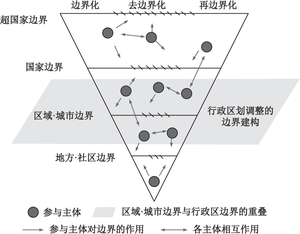
Administrative division is a significant strategy to govern national space. However, the increasing conflicts between administrative division adjustment (ADA) and the rapid urban development have seriously hindered the high-quality urban development and justice to governance. The existing studies focus on the measurement of economic effects and policy analysis, and lack the explanation of micro mechanism of ADA. The border construction theory form political geography provides a methodology for analyzing the micro mechanism of ADA. The paper argues that ADA is a process of border construction, driven by the joint action of multiple actors. It is considered that the ADA involves the alteration of location, belonging, attribute or level of the administrative boundary, and it is a continuous process of border construction. Although ADA is an important policy for state power allocation led by the government, the bottom-up forces such as the economic activities of enterprises and the daily life practice of residents also act on the formation and integration of administrative boundaries. As such, based on the perspective of border theory and the research on the "administrative boundaries" of ADA, the paper constructs an analytical framework for ADA including the process of bordering, dis-bordering and re-bordering, to investigate the role and interaction of multi-actors for the generation and elimination of the administrative boundary. Further, this framework is used to analyze the mechanism of border construction in "turning county to district" policy. The study can promote the multidisciplinary theoretical innovation between political geography and urban research, and is useful for practical policy formulation to solve the issues related to "border" and border region.
The article proposes an analytical framework about cross-system cooperation of transport supply in Guangdong-Hong Kong-Macao Greater Bay Area (GBA) under the co-effects of "government and market" by integrating transaction cost theory and institutional theory. It researches on the institutional barriers and the coordination mechanism of cross-system cooperation with a case study of Hong Kong-Zhuhai-Macao Bridge, which is a mega transport infrastructure crossing the "One Country, Two Systems" border. This study draws four conclusions. First, traffic organization, accessibility improvement and spatial development are the main consideration of local governments when planning cross-border transport infrastructure. Second, the negotiation dilemma results from high transaction costs and a lack of cross-system institutional coordination framework. Third, the key to facilitate cooperation is to establish a formal institutional coordination framework, which integrates market and administrative mechanism. Forth, the threshold of launching administrative mechanism is when the total net benefit of administrative coordination is significantly greater than that of market coordination. The cross-system coordination mechanism has significant implications while China moves forward its GBA Coordinated Regional Development and Transportation Power initiatives.

Based on the non-expected Super-SBM model, this paper measures the transformation efficiency of resource-based industries in 30 provinces from 2010 to 2018, and analyzes the evolution of the spatial-temporal pattern and influencing factors. The results show that: 1) the efficiency of resource-based industries in China has been continuously improved at an average annual growth rate of 6.26%, but there is still a big gap from effective development. Technological innovation is the main driving force to promote industrial efficiency, the optimization rate of scale efficiency has slowed down, and the motivation for continuous improvement is insufficient. 2) The transformation efficiency of resource-based industries in the country showed a ladder pattern of "the highest in the eastern China, followed by the central China, and the western and northeastern regions of China were relatively backward". The eastern and central regions of China maintained a rapid upward trend, while the western China slowly improved, and only the northeast China experienced a serious decline after 2014. 3) The transformation efficiency of resource-based industries in each province has a positive spatial correlation, and the agglomeration effect is increasing. At present, it is in the stage of high-level agglomeration, and the low-level agglomeration is basically solidified. 4) Industrial scale and environmental regulations have a significant promoting effect on the improvement of the transformation efficiency of resource-based industries, while institutional mechanisms and energy intensity inhibit the improvement of industrial transformation efficiency. Technology research and development only has a certain promoting effect in the eastern China, and the driving force of technology transformation in other regions is weaker.
The number and direction of China's population movements have changed substantially in the last few decades, which caused constant spatial restructuring. Migration is often a multi-stage process that migrants that migrantes may continue an onward migration after their fiyst spatial movement. However, existing studies have paid little attention to such dynamic processes. To fill this research gap, this paper analyzes the dynamic trajectory of migration and the network features of the spatial pattern, and further explores the influencing factors of the spatial choice of the onward migration by using social network analysis and the nested Logit model. The main findings are as followings: 1) The onward migration often occurs within ten years after the primary migration, with a decreasing migration distance. The majority of these onward migrants are married and tend to mirgate with family when they move again. It is also important to note that the onward migration does not always involve movement from cities in a lower hierarchy to a higher one, but presenting diversified patterns; 2) The primary migration network shows a very obvious cross-shaped diamond structure with the center of gravity to the east and south, while in the onward migration, the horizontal linkage becomes weaker, showing fewer pair cities with flows; 3) Spatial choices of onward migration are influenced by both individual and urban factors, among which the average wage in the destination city has the most significant influence, followed by individual characteristics and other urban factors. The higher the education level, the higher the administrative rank of migrants' place of origin, and the younger the onward migrants are in occupations requiring higher professional and technical knowledge and within the working age, the more they tend to flow to a Tier-one city. Based on the above empirical findings, the study further proposes relevant recommendations for different types of cities considering the characteristics of migration process: First, the cities with strong population attractiveness should actively improve facilities, public service conditions and enhance governance to increase the carrying capacity of the population. Second, different cities should be clear about the differences between themselves and other popular cities where the migrants tend to move. Given that migrants are more likely to choose destinations within the urban cluster in onward migration, the cities belonging to the cluster should utilize the population spillover effect of the core cities. They should actively adjust the industrial structure to promote the development of industries with obvious income pulling effect, strengthen the comprehensive urban governance capacity, and create ample urban amenities to attract the population. In view of the visible trend of family migration, cities should introduce corresponding policies in public services.
From the perspective of behavioral preferences, in order to obtain better living conditions and meet the needs of daily life, residents usually give priority to residential areas with high environmental quality or close to urban public centers with high mobility when choosing houses. This leads to differences in the residential vitality of different residential land and the ability of public centers with different mobility intensities to attract residential activities, thus affecting the utilization effect of urban residential land. The study breaks away from the traditional idea of allocating residential land according to the static population, interprets the actual residential demand from the perspective of vitality and mobility, measures residential vitality and mobility of public centers by using multi-source big data. What's more, the study explores the coupling relationship of vitality and carrying capacity, and the matching relationship of mobility and scale of attracted residential land by utilizing cluster analysis, coupling model and gravity model. Traditional statistics are also used to test the results, so that the optimization paths of residential land could be credibly concluded. The results show that: 1) From the perspective of vitality, it is believed that the coupling relationship between residential vitality and land carrying capacity can reflect the actual situation of residents' land use. The communities with high vitality are concentrated in the core city and Hexi Area, while the peripheral areas have low vitality on the whole, but some local coupling phenomenon exists. 2) From the perspective of mobility, it is believed that public centers have a great impact on residents' choice of residence. The attraction effect of commercial centers is similar and the general proportion scale can be concluded, while the attraction law of transportation and cultural and sports centers is not obvious. There are two paths of residential land optimization raised from the study: "guiding the optimal direction by the coupling degree" and "calculating the scale of additional land use by matching the mean value".
In this study, it takes advantage of multi-source geographic data to describe the characteristics of demand-supply of urban fitness fields that we consider that the data from statistical yearbook and questionnaire survey cannot effectively reveal the spatial characteristics of the supply-demand of fitness fields at a fine spatial scale. An evaluation model of spatial accessibility is constructed based on Gaussian two-step floating watershed method. Geographically weighted regression is then employed to detect the spatial heterogeneity of influencing factors so as to realize spatial cognition of urban fitness fields at a fine spatial scale. This study, which selects Changsha City as the research area, collects multi-source geographic data such as fitness fields distribution data, population distribution data and related impacts in this area, analyzes the spatial distribution characteristics of reachability of fitness fields from grid and street scales, and then discusses the variability of the relationship between reachability and influencing factors on a fine spatial scale. The results confirm that: 1) Here is an obvious imbalance of fitness fields at spatial dimension in Changsha. The Furong District has the highest spatial accessibility of fitness fields as well as the most serious the most serious in this area. The accessibilities in Yuelu, Kaifu, Yuhua and Tianxin Districts are generally similar, but there are great differences in variability in different regions; The accessibility and variability of Wangcheng District are the lowest among all regions. 2) The density of field and density of road network have both positive and negative effects on the accessibility of fitness fields, and the effects show significant spatial differentiation. The streets with greater positive effects on the accessibility of fitness fields for the density of field and density of road network are mainly locate in Furong and Kaifu District, respectively, while the streets with greater negative effects on fitness fields for both factors are concentrated in Yuelu District. The research can provide a significant support for the rational spatial layout optimization of fitness fields. Specifically, on the one hand, unbalanced spatial reachability needs to be focused in Changsha. On the other hand, targeted reachability promotion strategies can be formulated based on the differences of influencing factors in different regions.
Resilience is the basic attribute of the rural system, which reflects the rural system's response to external disturbances and shocks. High resilience rural has the ability to maintain system stability, minimize losses, and make comprehensive transformation and development. Rural resilience is the frontier direction of rural study. This article uses the CiteSpace to analyze papers on rural resilience domestic and abroad that has published before January 28, 2022. By drawing knowledge map, this paper aims to show the rural resilience study development process, research hotspots, latest directions and trends of future research. The study found that: 1) Foreign rural resilience study has established a complete knowledge system, which extends from basic concepts, theories and empirical studies to climate change, environmental protection, biodiversity and other fields. All these investigated rural resilience under different shocks. 2) The research on rural resilience domestic is still in initial stage, whose topic is few and scattered. The article indicates that future research should make full use of big data and simulation technology to reveal the evolution of rural systems, resilience thresholds and development shortage as well as rural resilience building under multiple stressors for rural revitalization and high quality development.
Based on the dynamics and activity of scale construction, this paper discusses the interaction of power between higher and lower scales in the development of Tanmen fishing port towns. Tanmen Town, located in Qionghai City in the northeast of Hainan Province, is a fishing port town bordering the South China Sea. Since the Song and Yuan dynasties, Tanmen's main source of livelihood has been far-sea fishing. By constructing the concept of "dependence stickiness", this paper discusses the scale effect of low-level agent's initiative strategy in Qionghai and Tanmen, and its relationship with the mechanism of scale reorganization. The results show that the transformation of Tanmen Town from "pre-restructuring stage" to "transition stage" and "post-restructuring stage" is a process of gradually establishing connections and adjusting with higher-order scale. The process of Tanmen scale reorganization is the result of the structural interaction of subjects of different high and low scales, such as state-region-local, among which the interactive logic among power, capital and space is the core mechanism. In the process of scale reorganization in Tanmen Town, the local subjects created and released the "dependence stickiness" between scales through national identity, space construction and cooperative alliance, and constantly promoted the virtuous cycle of scale reorganization. As a spatial unit between land and sea, Tanmen Town has enriched the research content and analysis framework between the development and scale reorganization of fishing port towns, and has a reference significance for the independent exploration of coastal urbanization and development mode in Hainan Province.
It is vital to improve the sustainable development capacity by building creative eco-systems and integrated areas. Relevant studies on industrial parks focus more on economic issues including agglomeration and innovation, but less on the comprehensive research and the micro-factors and evolutionary mechanisms. Therefore, the study constructs an evaluation system including enterprise development, life service, technology innovation, environmental protection, and land use. The coupling coordination model and obstacle degree model are used to analyze the spatiotemporal evolution and mechanism of synergetic development of sustainable development systems of industrial parks. The main results are as follows: 1) The coordination level of the sustainable development system of industrial parks in Shanghai is relatively higher and tends to increase but its gap is enlarging; 2) The spatial pattern of its coordination level can be verbalized as 'high coordination–high coupling but insufficient development –low coordination' from core urban areas to periphery urban areas; 3) The industrial parks are faced with different problems: lack of available land resources and coupling degree decreasing in the core urban area, undersupply of life service and short of innovation competence in the semi-periphery urban areas, low land-use efficiency and single development motivation in the periphery urban areas; 4) The resource agglomeration, driven by policies and the antagonistic competition between industrial parks, leads to spatial differentiation of sustainable development ability and expansion of the development gap. 5) Promoting urban construction can help to finish kinetic energy conversion from land exploitation to enterprise development, but tax policy don't. Therefore, transforming the development thinking that emphasizes economy and neglects society, and paying more attention to the coordinated construction of economic and social factors will help promote the sustainable development of the development zones.
Rural tourism is one of the effective ways to promote rural revitalization, which affects many aspects of rural residents' daily life and is related to their well-being. This study attempts to reveal the influencing factors and paths of residents' well-being in rural tourism destinations. Based on the man-land relationship, this study constructs an analytical framework for the well-being of the residents in rural tourism destinations. The spillover theory is used to explain the effect of influencing factors on residents' well-being, and both the external environment and residents' emotional conditions are being focused on. With the combined use of PLS-SEM and fsQCA, this study analyzes the conditions combination of the residents' high well-being based on testing the net effect of influencing factors and explores the types of paths that lead to the residents' high well-being in rural tourism development. In general, this study is expected to provide methodological support for the research on the happiness of rural tourism residents, and deepen the understanding of the role of tourism in improving the material and spiritual life of rural residents. The research findings claim that: 1) Emotional solidarity, environmental benefit perception, social and cultural benefit perception, and self-development have a significant positive impact on the residents' well-being in rural tourism destinations. However, the simple antecedent variables do not constitute a necessary condition for predicting the residents' high well-being that depends on the conditions combined with other elements. 2) Seven condition combinations have high explanatory power for the residents' high well-being. The dependence between self-development and economic benefit perception is the most obvious. Economic benefit perception shows two-way performance in the condition combination, and community participation is not outstanding in the condition combination. 3) According to the characteristics of the combination of the conditions, four types of paths leading to residents' high well-being can be summarized, in which the relationship elements represented by emotional solidarity and perception of social benefits play a key role in improving residents' well-being in rural tourism destinations. This study further confirms the complexity of the factors affecting the residents' well-being in rural tourism destinations and provides suggestions for the differential policies for formulating rural tourism development and improving residents' well-being in rural tourism destinations.
Space syntax emphasizes the ontological nature of space. People can analyze its internal cultural logic by analyzing people, activities and other space-time events in a specific space quantitatively. One of the key points of space syntax research is the study of people's spatial cognitive style, which uses people's local perception range as a means of spatial segmentation, and uses axis to simulate the structural relationship between the local perception space and the overall space. Under the background of Rural Revitalization Strategy, the characteristic protection and spatial vitality development of traditional villages are important issues in the current research. The research method of combining spatial syntax and image map can excavate the important cognitive space that is difficult to detect in the physical space, so as to provide a new research point for all-round traditional villages protection. Using space syntax to study the spatial form and the spatial cognition of space users is helpful to the protection and inheritance of traditional villages of ethnic minorities. Taking Jiaju Village in Congjiang County of Guizhou Province as the research object, this paper analyzes the spatial form of Jiaju Village. It investigates the spatial cognition of local people and tourists. The results show that: 1) The new core of Jiaju Village occupies a high-value area of integration, and its role of gathering people is increasing, while the old core maintains a central position due to the specific spatial structure and social function; 2) The linear streets and lanes with a high degree of integration, or the spatial elements connected with the axis with a high degree of integration, are more easily recognized by people, and the spatial elements perceived by villagers are more comprehensive; 3) The spatial cognition of villagers is closely related to the global integration degree, while the spatial cognition of tourists is more related to the local integration degree. This paper reveals the characteristics and causes of village spatial form and discusses the influence of spatial structure on the spatial cognition of local people and tourists. Finally, Based on the five elements of urban image proposed: Landmark, node, road, region and boundary, this paper constructs a spatial form and spatial cognitive protection framework of traditional villages of ethnic minorities from three aspects: node space, street space and spatial interface. By referring to the location of the spatial historical core obtained from the spatial syntax analysis results, and comprehensively considering the historical spatial memory and the actual situation, we orderly sort out the important cognitive nodes, use the streets and lanes to connect all the cognitive nodes in the settlement, strengthen the characteristics of the spatial interface, and form an overall cognitive sequence with the close combination of points, lines and planes, so that users can form a complete cognition of the village.
Based on the data of Mafengwo Travel Website from 2005 to 2022, this paper constructs the relationship matrix of tourists among various tourism elements in Xinjiang. With the help of the GN algorithm, spatial cascading system and spatial structure theory, this paper explores the role position of tourism system nodes, the organizational model and the hierarchy of associations structure. The results show that: 1) The large, medium and small scales of the tourism flow network level can be expressed by associations, nodes, and tourism-related activities, respectively, revealing the constraints of different tourism elements on the geographical spatial pattern. 2) The tourism flow network is identified by the community detection algorithm as 7 communities. There are two-way interactions, symbiotic effects, and complementary relationships within the communities, reflecting the different spatial interaction modes and network centralization degrees of tourist destinations. The composition of communities is manifested in space. The proximity, the jumping of a few parts, and the connection of multiple spaces. The traffic connection between communities presents an obvious distance attenuation effect. 3) Node roles can be divided into four types: Core node, sub-core node, sub-edge node, and edge node. The network structure is clear and hierarchical, and the roles of each node in the network are clearly defined. Based on the imperfect construction of the tourism flow network and the "faulted development" status of the number of core nodes in the northern and southern Xinjiang, suggestions for the development of Xinjiang's tourism network are proposed, to provide theoretical guidance for the high-quality development of large-scale provincial tourism.
This study takes the street space and public node space of ancient towns along the Lu Canal as the research object. After method comparison, the method of combining discrete mathematical graph theory and spatial syntax is selected. The topological structure and relevant parameters of the space are extracted by using the topological analysis software Pajek and the spatial syntax software Depthmap. The saturation level of the settlement space is analyzed through the obtained structural characteristics and parameter values. Combined with the spatial feature point elements and spatial features, the paper further analyzes the characteristics of the development and evolution of the settlement space, and reveals the driving factors of its spatial evolution. The results show that: 1) The canal water environment plays a key role in the spatial development of the ancient towns along the Lu Canal, and the initial development and evolution of the space are mainly concentrated on the spatial development of the river environment; 2) In the process of spatial development and evolution of ancient towns along the Lu Canal, water conservancy technology, economic industry, social system, history and culture have certain influence on spatial development and evolution; 3) Since modern times, the transformation of regional environment, political system, social culture and land transportation mode has caused the spatial development of the ancient town to gradually stagnate, the core role of water environment space has gradually weakened, and the directional development of road space has gradually become obvious. 4) Driving factors such as water environment, water conservancy engineering technology, economic and industrial technology, national political and economic forces, and canal culture have an important impact on the spatial evolution of ancient towns along the canal.
In this study, the western profile of Huaguang Reef, Xisha Islands, South China Sea was used as the test area, and the remote sensing images of Gaofen-1 (GF-1) and the "Ice, Cloud and Land Elevation 2" (ICESat-2) spaceborne laser altimetry satellite data were used. Based on the optimal strategy for modeling coral reef geomorphological zoning, a remote sensing inversion model for coral reef area shallower than 25 m was constructed. The extrapolation of the model was applied to the coral reef profile study areas in the Xisha Islands with field survey data. Modeling results show that the optimal models of reef slope and deep lagoon geomorphic zones were the band ratio binomial regression models, and they were the multi-band ratio regression models on the geomorphic zones of reef flat, shallow lagoon and patch reef. The correlation coefficient (R2) of the model inverted bathymetry data and field survey data is 0.95; The comprehensive verification by the field survey data and the ICESat-2 deep water data shows that the root mean square error of the model is 1.34 m, and the average absolute error is 1.08 m, and the average relative error is 17.10%. The research results show that the geomorphology-based active and passive remote sensing bathymetry inversion model proposed in this study significantly improves the accuracy of the medium-resolution remote sensing bathymetry inversion models in coral reef areas, and can provide method support for high-precision bathymetry retrieval in large-scale coral reef areas.
Evapotranspiration is the process by which water is dispersed to the atmosphere through the soil and vegetation surfaces, and it has an important impact on water resource consumption in the watershed. It is important to study the evapotranspiration process under the changing vegetation conditions to understand the water balance and water cycle in the watershed. Google Earth Engine (GEE) is a planetary-scale cloud platform for remote sensing imageries, it axiomatically has a primal advantage (e.g., premium communicating ecosystem and opening sources) in earth-science research. In this paper, the Loess Plateau was selected as the study area, on the platform of GEE, PML_V2 (2002—2017) and NDVI (1990—2020) datasets were applied, and linear regression, Mann-Kendall nonparametric test were used to quantitatively analyze the change of evapotranspiration components under the influence of vegetation changes on the Loess Plateau at a long-term scale. The results showed that: 1) The vegetation on the Loess Plateau showed a significant increasing trend (P<0.05) from 1990 to 2020, and the overall vegetation change was dominated by the trend of basic unchanged (31.2%) and slightly improved (59.4%), and gradually decreased from southeast to northwest spatially; 2) The vegetation transpiration on the Loess Plateau from 2002 to 2017 showed a significant increasing trend in vegetation transpiration and canopy interception evaporation (P<0.05) and with a non-significant decreasing trend in soil evaporation (P>0.05); 3) The increase in NDVI led to a decrease in soil evaporation (P<0.05) and increased vegetation transpiration and canopy interception evaporation (P<0.05). This study is beneficial to quantitatively clarify the impacts of the vegetated growing process and seasonal variations on the components of evapotranspiration, and provide scientific references for understanding the reciprocal feedback between vegetation changes and watershed eco-hydrological processes.
The study of impacts of drought on vegetation is one of the important ways to assess the impact of extreme climate on ecosystems. The dynamic pattern evolutions of drought has spatial and temporal characteristics. It is of great significance to analyze the impact of dynamic development of drought event on vegetation ecosystem in order to deeply understand the mechanism of drought and vegetation interaction. Based on a 3-dimensional drought clustering algorithm, we proposed a new method for quantitatively analyzing the vegetation response mechanism to droughts by accurately describing temporal continuity and dynamic extensibility of drought events. We investigated the temporal and spatial evolution characteristics of meteorological drought events and vegetation response to meteorological drought events on the Loess Plateau from 1982 to 2018 by identifying the 3-dimensional continuum of meteorological drought events. Results showed that: 1) The 3D drought events identified by the clustering algorithm on the Loess Plateau were convincible and reliable by the comparation with documented historical drought events. 2) We found that the NDVI value of drought affected area during drought period tended to be lower than that during pre-drought period by comparing the NDVI value in two periods and a good correlation was found between the NDVI reduction and meteorological drought events severity (R2=0.4389, P<0.05). 3) Further study showed that the NDVI cumulative reductions response quickly to SPEI cumulative reductions on the Loess Plateau. Grassland was the most sensitive and vulnerable to drought events which had the worst drought resistance by comparing the response characteristics of different land use types (cropland, grassland and forest) to drought events; However, cropland had suffered worst during severe drought events. Our findings provide crucial insights into scientific and reasonable understanding of the dynamic pattern evolution of 3D drought events and its influence mechanism on vegetation ecosystem.
This study investigated the spatial interactions of air pollution among China, Japan, and South Korea using daily time series data of PM2.5 ground monitoring from 2015 to 2019. Adopting a big data causal inference technique called Transfer Entropy method, which utilizes probability distribution to infer time series causality, the analysis was conducted from both national and city levels. The effective Transfer Entropy was employed to characterize the spatial interaction strength of air pollution, and the statistical significance of the estimated effective transfer entropy was further tested using the Markov bootstrap method. Ultimately, this study identified the spatial interaction intensity, relationships, and source structure decomposition of air pollution among the three countries. The study revealed the following findings: 1) In terms of the temporal evolution of PM2.5 concentration from 2015 to 2019, China had relatively higher PM2.5 concentration, but with a noticeable improvement trend. Japan and South Korea had relatively lighter air pollution issues, but showed a certain degree of deterioration trend. 2) In terms of the spatial interaction characteristics of air pollution, both at the national and city levels, the air pollution among China, Japan, and South Korea exhibited complex spatial interaction relationships, displaying a strong reciprocal interaction feature. This highlights the urgent need for collaborative air pollution control and governance among the three countries. 3) Regarding the transmission relationships of spatial interaction in air pollution, the spatial interaction among China, Japan, and South Korea has become increasingly interconnected. Theoretically, there are 870 transmission relationships between each pair of sample cities. From 2015 to 2019, the number of strong transmission relationships increased from 12 to 23, while the number of weak transmission relationships decreased from 662 to 625. The top five cities emitting the strongest intensity of air pollution are all located in South Korea, while in terms of receiving intensity, three cities are in Japan, and one city each in China and South Korea. South Korean cities have become the main source of spatial interaction in air pollution among the three countries. 4) In terms of the intensity of spatial interaction in air pollution, the spatial interaction intensity among China, Japan, and South Korea has been continuously increasing, rising from 6.12 bits in 2015 to 7.66 bits in 2019. The spatial interaction between countries contributes significantly, with an average contribution rate of 58.13%. Therefore, in addition to implementing domestic air pollution control measures, China, Japan, and South Korea should also engage in a series of initiatives such as scientific research exchanges, technology sharing, and the establishment of air pollution control funds to promote joint prevention and control of air pollution and multilateral cooperative governance. This study enriches the exploration of spatial interaction in air pollution among China, Japan, and South Korea, providing theoretical basis and practical support for the better implementation of joint prevention and control of air pollution and multilateral cooperative governance among three countries.
Hengshan area in Yulin City, which is sensitive to environmental changes, is located in the transition zone between the Mu Us Sandy Land and the Chinese Loess Plateau. There is a unique paleo aeolian sand loess sedimentary sequence in the Hengshan area, it is of great scientific value to reveal the evolution of East Asian monsoon and sandy land. In this study, the analysis of grain size distribution characteristics and parameterized end-member modeling of L3 and S3 layers in Liushumao section are used to discuss the sedimentary dynamic characteristics and climatic environment in Hengshan area. The results show that the grain size composition of L3 and S3 layers in the Liushumao section is mainly coarse silt (42.65%) and very fine sand (32.40%), and the median size (Md) is 47.11 μm. The grain size components in L3 and S3 layers were divided into four end members: EM1 (7.42 μm) is the fine silt component through a long distance transported and exists for a long time in the atmosphere; EM2 (43.66 μm) and EM3 (76.43 μm) are short-distance components carried by Winter Monsoon or sandstorms, EM4 (161.20 μm) is aeolian sand from the Mu Us Sandy Land, it is an alternative indicator of strong Winter Monsoon and strong sandstorms. The Liushumao section recorded that there was an extremely cold period, two cold periods and a warm period in the L3 period, and two warm periods and a cold period in the S3 period. At the same time, the Liushumao section recorded two expansion events and two contraction events of the Mu Us Sandy Land in L3 and S3 layers sedimentary development period.