
Cross the Yangtze River passages are of great significance in promoting integration of metropolitans, supporting the development of the Yangtze River Economic Belt and realizing the flow of elements between the north and the south of China. This paper sorts out the development of cross the Yangtze River passages on the Yangtze River mainline, and evaluates the regional connectivity of cross the Yangtze River highways using accessibility and weighted betweenness centrality. The study shows that: 1) according to the quantity, type and socio-economic development background, the construction process of passages can be divided into the initial stage (1957—1995), the speed-up expansion stage (1996—2010) and the multi-functional expansion stage (2011—). By June 2021, the ratio of passages in the upper, middle and lower the Yangtze River reaches is 54.7∶23.4∶21.9, while in terms of economic scale and resident population, the density of passages in the lower the Yangtze River reaches is much lower than that in the upper and middle reaches. 2) The accessibility of cross the Yangtze River highways has been significantly improved from 19.73 h to 6.09 h, and the time cost gap between the upper, middle and lower the Yangtze River reaches is narrowing; 3) The level of connectivity is substantially strengthened. The shortest path across the Yangtze River changes from highly dependent on several highways to multiple sharing. The high betweenness centrality highways are mainly located in the middle and lower reaches of the Yangtze River, while the connectivity of highways in the upper reaches is generally weak.
Accurate evaluation of the spatial convergence effect of major transportation projects is an important basis for engineering decision-making. The Shanghai-Zhoushan-Ningbo Cross-Sea Channel connects Shanghai, Zhoushan and Ningbo. It is an important part of the coastal transportation channel and a key project of the Yangshan Deepwater Port, and of great significance to the regional integration of the Yangtze River Delta. Considering the optimization of the future regional transportation networks, the impact of adjacent major transportation projects, differences between the passenger and freight transportation, and differences in travel modes, this paper evaluated the spatial convergence effects of the Shanghai-Zhoushan-Ningbo Cross-Sea Channel in multiple scenarios and multiple dimensions. Results show that, firstly, due to the competition and substitution effects of the Shanghai-Ningbo Cross-sea Channel, the Shanghai-Zhoushan-Ningbo Cross-Sea Channel has less impact on travel activities. Moreover, the Shanghai-Zhoushan-Ningbo Cross-sea Channel mainly serves intercity travel activities of Zhoushan, and has the potential to become a tourist channel connected Zhoushan, Shanghai, Suzhou and Nantong. Secondly, the Shanghai-Zhoushan-Ningbo Cross-sea Channel can enhance the competitive advantage of the Yangshan Deepwater Port in Zhejiang Province and the competitive advantage of Ningbo-Zhoushan Port in Jiangsu Province, which is conducive to the further cross-integration of the hinterlands of these two ports. Further, the impact of the Shanghai-Zhoushan-Ningbo Cross-sea Channel on the Yangshan Deepwater Port is significantly higher than that on Ningbo Zhoushan Port. Thirdly, compared with the Shanghai-Ningbo Cross-Sea Channel, the Shanghai-Zhoushan-Ningbo Cross-Sea Channel has advantages in freight transportation. In the future, the transportation demand forecast and scientific demonstration of the Shanghai- Zhoushan-Ningbo Cross-Sea Channel should focus on its freight function.
As a trunk railway in Southwest China, Sichuan-Xizang Railway has improved the transportation infrastructure in the western China, and is of great significance to the integration and coordinated development. This paper takes Sichuan-Xizang Railway as the research object, and calculates the accessibility of cities along the railway based on the network of roads and railways. Combined with the particularity of Sichuan and Xizang, the influence of Sichuan-Xizang Railway on urban accessibility and regional development is analyzed from the national scale, in order to provide reference for the coordinated development of China's trans-regional transportation infrastructure and regional development. The research results show: First, the construction of the Sichuan-Xizang Railway has notably enhanced accessibility for cities along the route. The once scattered circular layout has evolved into a corridor structure running parallel to the railway. Second, in comparison to Sichuan, the Sichuan-Xizang Railway has a more profound impact on the accessibility of cities in Xizang, particularly in the central locations like Linzhi and Changdu. Moreover, this impact extends beyond the railway route, enhancing connections between cities in Xizang and the rest of the country, particularly with the southwestern and southern regions. This suggests that the influence of the Sichuan-Xizang Railway extends throughout the entire Xizang. Third, Sichuan and Xizang are characterized by its concentration of economically disadvantaged counties and a diverse population of ethnic minorities, all while boasting abundant tourism resources. The railway significantly improves accessibility to border regions, impoverished counties, and autonomous counties inhabited by ethnic minorities. This has considerable implications for national security, ethnic unity, and regional integration and development. Finally, when viewed from an organizational network perspective, the introduction of train services along the Sichuan-Xizang Railway has enhanced the structural characteristics of the national high-speed rail network, with particular benefits for the southwest region. As the coverage of direct train services expands, cities in Xizang and Sichuan become more closely interconnected. In summary, the construction of the Sichuan-Xizang Railway is instrumental in facilitating connections between the southwest region, and eastern and central regions, with significant implications for national security, ethnic unity, and the promotion of regional integration and development.
This paper established an analysis framework of regional cross-border governance from politics of scale, then selected two cases of broken road between the central city and peripheral in the Yangtze River Delta, and finally conducted empirical research through participatory observation and semi-structured interview. Case study indicated that before the integration of the Yangtze River Delta became a national strategy, the phenomenon of broken roads were not only the absence of public affairs governance at city-region scale, it is also the development strategy of rational local government after trading off. In regional cooperation characterized with strong-weak combination, the asymmetry of discourse power and local selfishness lead to subjective obstacles of cooperation, and regional development and local financial strength differences, planning adjustment difficulties bring about objective obstacles. After the integration of the Yangtze River Delta became a national strategy, the central government incorporated broken roads connection into the work of local governments by compiling legally binding regional plans, and the public opinion urged the local government from bottom-up, which both make regional cooperation as the mainstream policy discourse. In this context, the local governments established a materialized regional coordination platform with both horizontal and vertical coordination functions, in order to break the information asymmetry between governments at the same and different levels, and promote the implementation of cooperation projects into the annual construction design plans of local governments through the preparation of regional cooperation action plans, which breaks the objective obstacles of construction land index and construction fund shortage. In this sense, the regional coordination platform becomes an effective supplement to the existing administrative management system.
Land serves as a spatial carrier of various resource elements, while improving efficiency of land use is the key breakthrough to resolve the contradiction between man and land. Based on the panel data of 269 prefecture-level cities (not including the data of Xizang, Hong Kong, Macao and Taiwan) in China from 2008 to 2019, this paper first uses the super-efficiency EBM-DEA model and ArcGIS spatial analysis to explore the evolutionary characteristics of green efficiency of urban construction land; secondly, combined with the spatial Durbin model under different weight matrices, this paper reveals the spatial effects of industrial agglomeration and environmental regulation on the green efficiency of urban construction land. The results show that: 1) During the study period, the green efficiency of urban construction land in China has strong spatial and temporal heterogeneity, and the gradient distribution pattern of "high in the east and low in the west" is more prominent. 2) The spatial effect of industrial agglomeration on the green efficiency of urban construction land has a significant "U"-shaped relationship; only when industrial agglomeration exceeds a certain threshold can the "Solow Paradox" be effectively broken through, thereby improving the green efficiency of urban construction land in local and neighboring areas. 3) The "innovation compensation" effect of environmental regulations is greater than the "compliance cost", which to a certain extent verifies the applicability of the "Porter hypothesis" in the green efficiency of urban construction land in China; however, the "crowding out effect" of environmental regulations may also make neighboring cities "pollution refuges", thereby reducing the green efficiency of urban construction land. It is expected that this study will provide a reference for rationally guiding the formulation of industrial agglomeration and environmental regulation policies, achieving high-quality development of urban construction land.
With the improvement of living standards, non-commuting travel has become an important demand. Related research has also become a focal point in the geography and other fields. Taking Nanjing metropolitan area as an example, this paper collected multi-source data such as mobile phone signaling data and POI data, and used random forest model and other methods to explore the non-commuting travel characteristics and non-linear influencing factors in and between cities. The study reveals the following findings: 1) The non-commuting travel in cities was concentrated in the central urban areas, and the non-commuting travel between cities was concentrated in the junction area and the center of Nanjing. Among the four types of townships, comprehensive townships were mainly distributed in the central urban area of Nanjing, inflow-type townships were primarily located in the central urban areas of various cities, and outflow-type townships were mainly distributed in the adjacent areas between cities. 2) The built environment had a non-linear effect on non-commuting travel, so traditional linear model analysis has shortcomings. Specifically, non-commuting travel in cities was subject to public and transportation facilities. Non-commuting travel between cities was primarily affected by the transportation infrastructure but was also influenced to a certain extent by large-scale public service facilities. 3) Different influence factors had different non-linear mechanism, including those with clear upper thresholds, clear lower thresholds, both upper and lower thresholds, and those without obvious threshold effects. It was necessary to plan according to the characteristics of facilities. Finally, this paper put forward the optimal allocation strategy of metropolitan based on characteristics of non-commuting travel and the non-linear mechanism of built environment. By considering the attributes of different townships, the following plan should involve tailored facility planning and configuration within the metropolitan area, while also taking into account thresholds and nonlinear impact mechanisms.
Based on the analysis of the interaction mechanism between the spatial transfer of manufacturing industry and carbon emissions under the carbon policy, this paper uses the quasi-cost-benefit analysis model integrated with location factors to construct the gravitational mechanism and centrifugal mechanism of the location choice of manufacturing firm based on the carbon policy, and deduce the "reshaping mechanism" of the spatial transfer of manufacturing industry on the carbon emission pattern. From the empirical point of view, the spatial effect is verified by using the spatial proximity impact model based on parameter improvement and the geographical weighted regression method. The findings are as follows: 1) The effect of carbon policy on production behavior and location choice of firm is mainly centrifugal, and restrictive carbon policy tends to lead to location transfer of manufacturing firm. 2) No matter what kind of carbon policy, firm tend to carry out production with carbon emission ceiling, and regional carbon emission is influenced by firm's production behavior, location choice and carbon policy choice. 3) From the "Twelfth Five-Year Plan" to the "Thirteenth Five-Year Plan" period, the spatial transfer of the manufacturing industry showed obvious characteristics of leap-forward diffusion and nearby diffusion, and the distribution and agglomeration of the industry transferred out of the place and into the place. 4) The regional carbon emission pattern is the equilibrium result produced by the government and the market for firm through gravitational mechanisms and centrifuges. The transfer of low-carbon and high-carbon manufacturing firm makes the carbon emission pattern present a state of relative agglomeration-relative dispersion-absolute agglomeration. 5) Compared with the "Thirteenth Five-Year Plan" period, the carbon policy showed a shrinking trend, and the intensity and intensity of the policy continued to increase. Under centrifugal action, manufacturing firm tend to transfer to areas with low carbon control.
Multi-dimensional proximities provide an important theoretical perspective to explore the mechanism of urban network. This study expands the multi-dimensional proximities theory from the innovation network to the inter-firm connections network of cultural industry firms represented by the film industry. Based on division of film industry chain from 2011 to 2019, this study analyzes the structure of urban film network, and explores the influence of multi-dimensional proximities on inter-city connections and the difference of urban subjects. The study found that: 1) China's urban film network presents a radial structure with Beijing as the core, but not the "diamond structure" common to urban networks of other industries. 2) During the period of the rapid development of China's film industry, the industrial chain connection between cities depended more on policy proximity and organizational proximity, rather than geographical proximity. Economic potential difference and industrial structure dominated by the service industry also have a significant positive impact on inter-city connections. 3) Multi-dimensional proximities has a different influence on inter-city connections with different development bases in film production activities. Cities with a strong foundation for development in film production activities are mainly affected by the multi-dimensional proximities with other cities, while cities with a weak foundation for development are also significantly affected by their own economic capacity and industrial structure. Policy proximity and organizational proximity play significant positive effects in inter-city connections between the high-connectivity cities with strong development. With the deepening of the film industry's marketization, organization proximity and economic potential difference show significant positive effect in inter-city connections between high-connectivity cities, medium- and low-connectivity cities with relatively weak development foundation. The organization proximity and industrial structure dominated by service industry can significantly promote inter-city connections between low-connectivity cities, while the significant of policy proximity's positive impact is weakened or no longer significant.
In the context of the new round of the development in the western China, civil aviation transportation is an important driving force to promote tourism development there. Based on the panel data of tourism revenue and civil aviation passenger traffic in 12 provincial administrative regions in western China from 2005 to 2019 and the spatial cross-section data of tourist attractions and airport locations in 2020, this paper explores the spatio-temporal relationship between civil aviation transportation and tourism development in the western China with the help of kernel density, airport accessibility analysis, and PVAR dynamic model. The results of the study show that: 1) The spatial relationship, the overall distribution of tourism resources in the western China and the airport layout basically coincide with each other, and the airport layout is also relatively dense in areas rich in tourism resources, and the spatial correlation between the two is relatively strong; however, there are some differences in spatial coordination among provinces, and from the degree of coordination, it can be classified into three categories: high-quality coordinated development area, well-coordinated development area, and primary coordinated development area; 2) The western China presents a situation where civil aviation transportation has a stronger one-way influence on tourism development, and the two have not formed a long-term interactive mechanism. The development of civil aviation transportation in the western China, its own internal driving force has obvious advantages, while the tourism industry's contribution to its development is low, in promoting the development of the civil aviation industry is not obvious; at the same time, the tourism industry in driving its own side also shows a trend of insufficient strength, its own thrust is difficult to support the long-term development of tourism, while civil aviation transportation on its driving force is showing a clear trend of enhancement, which makes the pace of transforming tourism resources into tourism industry in the western China will be inevitably accelerated; 3) From the contribution of control variables, financial expenditure on civil aviation transportation industry has a stronger role in promoting the develofiscal expenditure, which has a stronger driving effect on the civil aviation transportation industry. Compared with fiscal expenditure, tourism development is instead more dependent on the level of regional economic development and the density of the regional land transportation network. The size of the urbanization acts a certain supportive role in helping the development of both civil aviation transportation and tourism.
In the process of promoting the ecological protection and high-quality development strategy of the Yellow River Basin, financial agglomeration plays an important role that cannot be ignored. By using the data of 75 sample cities in the Yellow River Basin from 2007 to 2019, a spatial partition map was drawn to analyze the spatial and temporal pattern of financial agglomeration and green economic efficiency in the Yellow River Basin. Then, a panel econometric model was constructed to examine the impact of financial agglomeration on green economy efficiency in the Yellow River Basin and the regulatory role played by environmental regulations. Finally, the spatial Dubin model is constructed to test the spatial spillover effect of financial agglomeration on green economy efficiency. The results show that: 1) There are significant spatial differences between financial agglomeration and green economy efficiency in the Yellow River Basin, which not only show consistency, but also have certain dislocation. 2) The effect of financial agglomeration on green economic efficiency in the Yellow River Basin is "inverted U-shaped", and environmental regulation plays a positive moderating role in this process. 3) The nonlinear effect of financial agglomeration on green economic efficiency and the positive moderating effect of environmental regulation show heterogeneity in the upper, middle and lower reaches of the Yellow River Basin. 4) The spatial spillover effect of financial agglomeration on green economic efficiency in the Yellow River Basin also shows an "inverted U-shaped", and the spatial spillover effect shows heterogeneity in the upper, middle and lower reaches of the cities. The conclusion of this study has important reference significance for improving the ability of financial services to serve the real economy to promote ecological protection and high-quality development of the Yellow River Basin. According to the research conclusions, this paper puts forward four policy recommendations: First, to guide the Yellow River Basin to promote the financial agglomeration reasonably, maximize its economic and environmental effects; Second, we should continue to improve and strictly implement environmental regulation policies in the Yellow River Basin, and assist financial institutions in identifying green projects to achieve green development. In addition, the cities in the upper, middle and lower reaches of the Yellow River Basin should be developed according to local conditions. Finally, the spatial layout of the financial industry in the Yellow River Basin is optimized, and the construction of the regional financial center system is planned to fully release the spatial spillover dividends of financial agglomeration and promote the coordinated improvement of the green economy efficiency in the Yellow River Basin.
Based on the connotation of green development of mariculture industry, this study constructs a comprehensive evaluation index system of green development of mariculture industry with 18 specific indicators in 4 dimensions of environment friendliness, economic efficiency, green technological innovation and spatial expansion, and adopts AHP-EW-TOPSIS comprehensive weight optimization evaluation model for the quantitative evaluation of the green development level of mariculture industry in 9 provinces (regions) along the coast of China in 2004-2020. At the same time, this paper uses the coefficient of variation method and the barrier degree model to deeply analyze the regional differences and main barrier factors of the green development of China's mariculture industry. It is found that: 1) The overall level of green development of China's mariculture industry from 2004 to 2020 shows a fluctuating upward trend. From the perspective of spatial changes, the spatial changes of green development of Chinese mariculture industry are obvious and gradually formed a three-legged pattern of green development of mariculture industry with Shandong, Jiangsu and Hainan as the cores in the northern, eastern and southern coastal areas. 2) From the perspective of regional differences, the regional differences in the level of green development of China's mariculture industry are gradually expanding. Specifically, the variation index of the environment-friendly dimension is gradually decreasing, the variation index of the economic efficiency dimension is significantly increasing, and the variation index of the green technological innovation dimension and the spatial expansion dimension are both on a slight upward trend. This indicates that the regional differences in the level of green development of China's mariculture industry during the study period mainly originate from the economic efficiency dimension. 3) From the viewpoint of barrier factors, the main barrier factors for the green development of China's mariculture industry come from the economic efficiency and spatial expansion dimensions and the barrier degree on the spatial expansion dimension still tends to increase. According to the main obstacle factors of each region, it can classify the green development of mariculture industry in coastal areas of China into three categories: efficiency obstacle type, technology obstacle type and spatial obstacle type. Among them, Shandong and Fujian belong to efficiency barrier type, Hebei, Liaoning and Hainan belong to technology barrier type, and Jiangsu, Zhejiang, Guangdong and Guangxi belong to spatial barrier type. Based on this, this paper argues that each region should fully consider the main obstacles to the green development of its own mariculture industry and change its green development ideas according to local conditions.
Establishing and improving the system and mechanism for the integrated development of urban and rural areas is a key aspect of the rural revitalization strategy. In China, the county serves as a combination of urban and rural governance, and promoting urban-rural integration at the county level holds great significance in further advancing the high-quality development of both urban and rural areas. This paper evaluated the level of urban-rural integration and examined the differentiation path of 26 mountainous counties in Zhejiang Province, China from 1995 to 2020, utilizing various methods such as a comprehensive evaluation method, coefficient of variation, coupling coordination degree, and obstacle degree model. The findings indicate the following: 1) The comprehensive level of urban-rural integration in the 26 mountainous counties displayed a steady increase and exhibited a cluster distribution pattern. On a sub-dimension level, the urban-rural integration level of each element has risen, while the disparity between the integration levels of each element has gradually widened. 2) The coordination interaction among the elements in the 26 mountainous counties has been progressively enhanced. The coupling coordination degree was divided into two-time points in 2008 and 2018, signifying a transition from near disharmony to barely coordination, and then to primary coordination. From a multidimensional perspective, there are 48 coupling modes in the 26 mountainous counties. However, there was a lack of positive mutual feedback among innovative factors, and the coordination and interaction effects with other factors are weak. 3) Several issues exist in the urban-rural integrated development of the 26 mountainous counties, including a significant income gap between urban and rural residents, insufficient reach and depth of technical elements, and inadequate driving force for the high-quality development of urban-rural integration. In the future, the differentiation path of urban-rural integration at the county level can be explored through four aspects: strengthening the flow and combination of factors, promoting industrial transformation and upgrading, overcoming major obstacles, and enhancing regional connectivity. By doing so, high-quality urban-rural integration development can be achieved.
This paper uses quantitative models such as nuclear density analysis, GWR model and geographical detector to explore the spatial type characteristics, influencing factors and driven mechanism of 168 national comprehensive tourism demonstration zone in China. The result shows: 1) The national comprehensive tourism demonstration zone is centered on the Yangtze River and the Yellow River, with a spatial distribution pattern of "one core, multiple areas and double corridors". 2) The structure of destination types in the national comprehensive tourism demonstration zone shows a trend of partial aggregation and overall disequilibrium with the highest and lowest proportion of core scenic spots, historical and cultural heritage types, it is mainly distributed in the Yangtze River Delta, Beijing-Tianjin-Hebei, Central Plains and Chengdu-Chongqing and other metropolitans. 3) Tourism attractions, services and facilities, economy and policy, physical and geographical basis, market and traffic location and other factors constitute the driven mechanism of the spatial distribution of the demonstration zone, each factor has a local promotion or inhibition effect. 4) The main factors of the spatial distribution of each type's demonstration zone are different, and the interaction of two factors significantly improves its spatial interpretation, which is manifested as nonlinear and double-factor enhancement effect. Resource centripetal force, market traction force, economic driving force, traffic accessibility force, service integration force and environmental comfort build a six-dimensional dynamic model of its spatial distribution.
Exploring the evolution of dietary pattern and their health effects is of great significance for the implementation of food security and Healthy China initiative. Focusing on multiple scales such as "three major regions, nine agricultural regions—provincial units", this paper explored the regional evolution characteristics of the dietary pattern of Chinese residents from 1987 to 2017, and deeply analyzed the health effects of changes in the dietary pattern of residents. The results showed that: 1) The dietary pattern of Chinese residents had gradually changed from "grain and vegetable-based" to "diversified consumption", and the dietary quality had generally improved while the intake of animal-sourced food had increased significantly. 2) Differences in the human-environment relationships drove the evolution of dietary pattern in different regions from a multi-scale perspective: The proportion of animal-source food consumption in the eastern region had risen fastest, the western region had always been the region with the highest proportion of oil and fat consumption, and the central region had the smallest decline in grain consumption; The consumption of animal-sourced food in the nine agricultural regions all showed an upward trend, and the consumption of other types of meals was different; The dietary pattern of residents in each province had not yet formed a significant territorial spatial differentiation pattern. 3) Malignant tumors, heart disease, cerebrovascular disease, and endocrine nutrition and metabolic diseases were significantly positively correlated with the consumption of animal-derived foods and oils, and were significantly negatively correlated with the food consumption. The research results are expected to provide theoretical basis and practical reference for scientifically formulating strategies to balance the dietary pattern of Chinese urban and rural residents.
On the basis of discussing the flow pattern of water resources in China, an analysis of the driving factors that affect the formation and change of the flow pattern of water resources can provide a theoretical basis for more reasonable planning and regulation of water resources. Based on the perspective of water footprint, this article uses the multi-regional input-output model (MRIO) to analyze the water footprint flow pattern of various industries in China from 2002 to 2017, and uses the spatial-temporal geographic weighted regression model (GTWR) to comprehensively considera total of 20 indicators of nature, social economy and technology, and respectively discusses the driving factors that affect China's inter-provincial inflow and outflow virtual water. The results shows that: 1) During the research period, the proportion of inflow and outflow virtual water of various industries has changed. Agriculture has always accounted for a large proportion, industry has shown a declining trend, and the proportion of service industry has gradually increased, and is second only to agriculture in 2017; 2) In the flow pattern, the inflow virtual water of each industry in most eastern regions is higher than the outflow virtual water, and the outflow virtual water of each industry in most central and western regions is higher than the inflow virtual water; 3) Among the driving factors of the temporal and spatial changes of the inflow virtual water, the growth of industrial influence, total population, water resources carrying capacity and other factors have a significant promoting effect on the increase of the inflow water footprint, while the proportion of cultivated land under irrigation and total R&D investment will limit the increase in the inflow virtual water; 4) The growth of total population, traffic density, water consumption per unit of GDP and other factors will promote the increase of outflow virtual water, while the increase of energy consumption per unit of GDP, industrial influence, total R&D investment and other factors will hinder the increase of outflow virtual water.
Taking the Datian River Basin in Zhejiang Province as an example, three field surveys were conducted with the support of participatory geographic information system (PGIS). Six flooding scenarios were simulated, using the HEC-HMS hydrological and HAND-based inundation model. Multi-scenario-based flood risk was analyzed at the community scale by: 1) Conducting flood hazard simulation and evaluation; 2) Mapping the footprint, height, economic values, and exposed assets of residential building; and 3) Incorporating the vulnerability curves of residential buildings and household properties estimated using data collected from field surveys. The results showed that, PGIS-assisted questionnaire survey and household interview methods can effectively collect local flood prevention knowledge and assist risk analysis. Comparison between the risk assessments of the 2-year and 500-year floods showed that: the footprint of inundated buildings increased from 6.72% to 61.44%; and the total exposed assets increased from 2.32×10⁹ to 22.25×10⁹ yuan; The flood potential losses rose from 0.39×10⁹ to 5.42×10⁹ yuan, and the expected annual flood damage (EAD) is 0.49×10⁹ yuan/year. These results indicate it is necessary to take comprehensive flood adaptation measures to cope with the potentially increasing flood risk. The framework proposed in this study can provide insights into community-based flood risk analysis.
Exploring the time lag relationship and its influencing factors of meteorological and hydrological drought in the Yellow River Basin can provide a scientific basis for drought monitoring and prevention in the Yellow River Basin. In this study, based on the climate data of ERA5 and the water storage product of GRACE gravity satellite, the standard precipitation evapotranspiration index (SPEI) and the standardized water storage index (SWSI) of the Yellow River Basin were calculated, and the time lag effect between SPEI and SWSI was explored by Spearman rank correlation method. The main influencing factors of the spatial difference in the time lag effect between SPEI and SWSI and the interaction between these factors were analyzed by using the geographic detector model. The research results show that the time lag of meteorological and hydrological drought in the Yellow River Basin has obvious spatial heterogeneity. The lag time of SWSI and SPEI is different in different months. The average lag time of spring and winter is 3 months, and that of summer and autumn is 4 months. Soil type has the greatest impact on the time lag difference, followed by meteorological factors and human activities. Among the meteorological factors, the potential evapotranspiration has the greatest influence. The interaction between different factors is greater than that of single factor. In the two factor interaction, the interaction between soil type and potential evapotranspiration is the most significant, followed by that of soil type and average temperature and that of soil type and potential evapotranspiration.
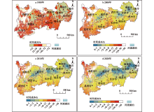
At present, the regional air environment problem characterized by PM2.5 has become increasingly prominent. The atmosphere particulate pollution occurred frequently in Northeast China over past years which is one of the main regions of air pollution. The spatial distribution of near-surface PM2.5 stations is sparse, and time series of data are short. Therefore, using the near-surface PM2.5 concentration data can not analyse the variation of reginal air pollution. Based on near-surface PM2.5 concentration data, MODIS 10 km aerosol optical depth (AOD), ERA5 reanalysis meteorological data and digital elevation model (DEM), multiple linear regression (MLR), linear mixed effects (LME) model and random forest model (RF) were selected to estimate PM2.5 concentration in Northeast China from 2014 to 2018. The accuracies of three models were evaluated by means of ten-fold cross validation. On that basis, the optimal model was used to simulate daily PM2.5 concentration in Northeast China from 2009 to 2018. The results showed that: 1) Correlation coefficients (R2) between the estimated and observed PM2.5 concentration by three models were ranked as RF>LME>MLR. The RF model had the highest accuracy. 2) TheR2 of the estimated and observed PM2.5 concentration by RF model was higher than 0.93 in different seasons and months. It was feasible to estimate PM2.5 concentration in Northeast China by RF model. 3) The annual average PM2.5 concentration showed interannual trend of first increasing then decreasing in Northeast China from 2009 to 2018. And it had seasonal variation characteristics of winter>spring>autumn> summer. In addition, the average PM2.5 concentration decreased gradually from southwest to northeast, that was shown as Liaoning>Jilin>Heilongjiang. By establishing a long time-series PM2.5 concentration dataset, this study contributes to estimate the spatial-temporal distribution of PM2.5 concentration, and also may be useful to analyse the weather change characteristics and formation mechanism of heavy pollution in Northeast China.