
It is of great significance to analyze the structural characteristics and differences of urban network from different perspectives for deeply understanding the structural mode of China's urban network. In this study, urban network in China is constructed and compared based on the relationship data of Huawei's supplier value chain from 2019 to 2022 and the head-branch relationship data of China's top 100 intelligent manufacturing companies. The results show that: 1) From the perspective of value chain, the structure of nodes in China is significantly different and clearly hierarchical, and the distribution patterns of rank-size grows exponentially in segments. As for spatial structure, the axis connection structure is of heterogeneity, the city is stratified by clusters, and the whole network is controlled by the core urban nodes. 2) The node structure of China's urban network from the perspective of headquarters branch is similar to value chain, and the distribution patterns of rank-size increases exponentially. Spatial structure of urban network highlights the national central node status of Beijing, Shanghai and Shenzhen, and the spatial structure shows a "gem structure". 3) By comparing the findings from the value chain and the headquarters branch perspective, the results show that the control power, core structure, hierarchical features, and connectivity characteristics of the two types of network nodes exhibit similarities. The axial connections between the two types of urban nodes rely on the control of national core cities such as Beijing, Shanghai, and Shenzhen. The node weights and edge weights in the urban network under both perspectives follow a power-law distribution. However, the value chain perspective can reflect the diversity of complex connections between cities, and the differences in nodes and the imbalance of network connectivity are more pronounced in the value chain perspective. 4) The comparison shows that the value chain also can depict the Chinese urban network reliably and the value chain network of leading smart manufacturing suppliers can represent the interconnected network of smart manufacturing companies in China. The structure of nodes and axes in the urban network under two perspectives is highly similar. In addition, the value chain revels the regional spatial structure from the perspective of urban functional connection, which helps researchers to get out of the data ocean and make scientific decisions for urban and regional spatial planning and development.

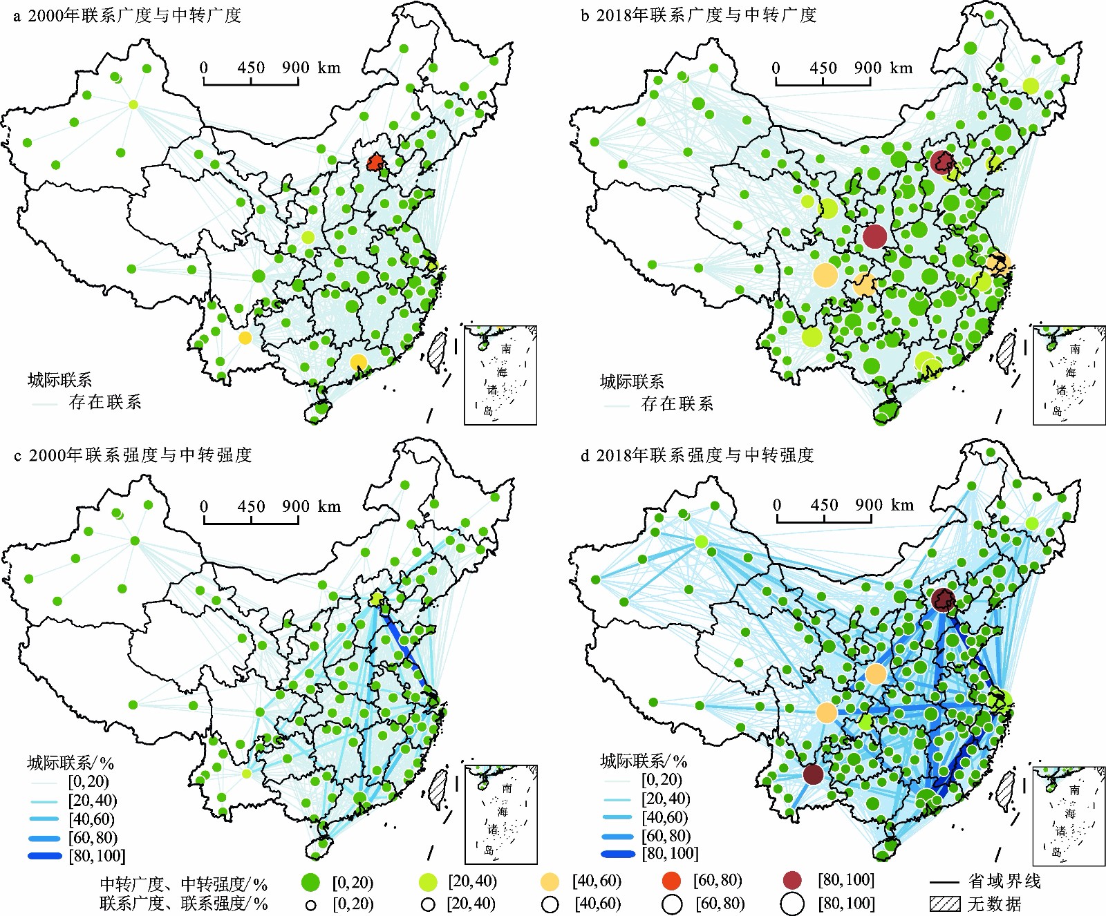
"Hub-spoke" structural characteristics of the aviation network, differences of capacity in actual route, as well as the functional positioning of different aviation hubs by the authorities, endow cities with functional differences in "connection" and "transit", as well as functional differences in "breadth" and "intensity" when considering the weight of routes. Taking into account different definitions of "centrality" and the link weight in aviation networks, the study measures the connection breadth, transit breadth, connection intensity and transit intensity of node cities, and then reveals the spatiotemporal evolution features of China's aviation network from a multidimensional centrality perspective. The study selects the domestic flights from 2000 to 2018 in the OAG (Official Aviation Guide) global aviation database, and the matrix is constructed based on the direct flight route between cities at prefecture-level and above to map the Chinese aviation network. Furthermore, according to the particularity of aviation networks, this study rectifies indicators such as weighted betweenness centrality to ameliorate the method system for measuring the nodal functions in aviation networks. There are three main findings. First, in general, from 2000 to 2018, the connection breadth, connection intensity, transit breadth and transit intensity of the urban nodes of China's aviation network increased. Different types of urban functions have obvious hierarchical characteristics but intensity indicators are more polarized than breadth indicators, and transit functions are more polarized than connection functions. Over time, the central cities with different functions have extended to the central and western regions, while the connection functions of cities have become flatter. Second, although there are significant differences in the distribution patterns of cities with different functional advantages, the functions of various nodes in high-level administrative cities are generally balanced. Thirdly, cities with more advantageous connection intensity, compared with breadth, are mainly located in areas with competitive advantages in air travel or on the edge of high-speed rail networks and areas without high-speed rail access; In comparison with transit breadth, cities with an advantage in transit intensity and high connectivity are generally capital cities near frontier; cities with more advantages in transit function compared to connection function are mostly located in remote areas, but the aviation mode mapped by intensity indicators is more in line with the spatial economic and geographical pattern. The study has scientifically assessed the nodal positions of cities in the aviation network, which has important practical significance for utilizing the comparative advantages of aviation cities and optimizing route layout. In the future, we can optimize the transportation efficiency of China's aviation network by strengthening the construction of hub airports, reasonably planning the aviation network, and coordinating routes and flights. Furthermore, regional aviation can be further used as a focus to leverage the development of civil aviation in remote areas, improve transportation conditions in remote areas, and promote regional economic development. In addition, it is suggested to optimize and adjust routes and flights in a timely manner according to the construction process of the high-speed rail network, and improving the comprehensive rapid transportation efficiency of "aviation plus high-speed rail" is necessary.
Urban agglomerations are the main spatial carriers of regional development elements. It is significant to characterize the spatial structure of economic networks and the underlying mechanisms in urban agglomerations, which sheds light on regional integration and high-quality urban development. This study takes the urban agglomeration in the middle reaches of the Yangtze River in China as the case to evaluate urban competitiveness, examine spatial differentiation of intercity economic linkages and investigate the driving factors of centrality in the city network. Based on 28 prefecture-level cities in the study area, we firstly evaluate urban competitiveness based on the entropy method from four dimensions: economic development, cultural innovation, green development and liveability. Then the multi-mode traffic flows and the radiation model are combined to calculate the intercity linkages of urban competitiveness and examine their spatial patterns. Social network analysis is employed to characterize the in-degree and out-degree centrality, and the spatial econometric models are used to examine the possible driving factors of urban centrality in the economic networks. 1) The intensity of multi-mode traffic flows is stronger in three regional central cities (Wuhan, Changsha, and Nanchang) and demonstrates the spatial pattern of 'weak in the northern part and strong in the southern part divided by the Yangtze River'. The pattern of high-speed rail traffic flows is spatially unbalanced in the three provinces (Hubei, Hunan, and Jiangxi) while the pattern of passenger transport flows is more balanced among prefecture-level cities. 2) According to the intercity linkages of urban competitiveness, Wuhan and Changsha are the only two regional hub cities with strong economic radiation to peripheral cities. However, Xiangtan and Huangshi demonstrate strong economic dependence to the hub cities. Weak linkages are widely present between prefecture-level cities while strong linkages exist only among the three provincial capital cities. 3) The centrality degree in provincial capital city is much higher than other prefecture-level cities. The cities in Hunan Province have higher centrality than Hubei and Jiangxi. The spatial consistency of in-degree centrality and out-degree centrality demonstrates the bi-directional linkages between cities with the dynamic process of both agglomeration and diffusion. 4) Administrative hierarchy, economic development and globalization are the three major driving factors of out-degree centrality, while economic development and marketization are the two significant determinants of in-degree centrality. With the advent of geographic big data, and information and communication technologies, it becomes significant to examine intercity network structures from the perspective of geographic flows especially the multi-mode traffic flows. The radiation model is superior to the conventional gravity model in characterizing the heterogeneous spatial process of multiple elements guided by transport networks. Geospatial analysis and social network analysis are combined to understand the complexity of intercity economic linkages, such as spatial radiation, spatial dependence and spatial differentiation. The major findings in spatial pattern and determinants of economic networks help policy-makers and urban planners to guide regional integration, high-quality urban development and new-type urbanization.
Under the frameworks of CAFTA and RCEP, ASEAN and China have achieved comprehensive improvements in various fields such as economic investment, business trade and technological cooperation. To clearly delineate the spatial spillover of China-ASEAN regional trade, this study utilizes the exploratory spatial data analysis (ESDA) method to investigate the spatial dependence, heterogeneity, and autocorrelation among the 31 provinces and regions in China concerning ASEAN in 2019 and 2020. The research shows that: 1) The spatial statistical characteristics of China-ASEAN regional import and export trade are evident, and they exhibit a spatial dependency pattern from the "edge to center." In other words, import and export trade are concentrated in the eastern coastal regions and demonstrate a significant spatial agglomeration relationship. 2) When considering first-order adjacency spatial weights, the global Moran's I index passes a significance test, indicating the presence of spatial autocorrelation in China-ASEAN regional import and export trade. However, under second-order adjacency and spatial distance weights, the diminishing significance of import and export trade suggests that the spatial spillover of trade in the China-ASEAN region displays a spatial attenuation feature as neighborhood order increases. 3) Import and export trade between China and the ASEAN region exhibits a high coefficient of variation, signifying spatial variability in China-ASEAN regional trade. However, this high coefficient of variation also implies that both imports and exports display spatial non-stationary characteristics. 4) The presence of spatial interdependence, spatial autocorrelation, and spatial variability in China-ASEAN regional trade further underscores the existence of spatial spillovers in China-ASEAN regional trade. A significant trade imbalance is observed among the 10 ASEAN countries, with ASEAN imports from China forming high growth clusters in the eastern region of the trans-Asian Railway, encompassing Vietnam, Malaysia, Thailand, and Cambodia. 5) The LISA test identifies that Fujian has a significant spillover effect on the surrounding neighborhood space. Additionally, Guizhou, Yunnan, and Sichuan in the southwest China, as well as Fujian, Hunan, Jiangxi, and Guangdong in the southeast China, have formed high export growth clusters. China-ASEAN have collectively contributed significantly to regional peace, stability, and prosperity. These research findings not only provide insights and decision-making support for promoting balanced development in China-ASEAN regional trade but also facilitate the optimization of a high-standard global free trade area network.

Under the background of complicated international situation, the economic cooperation in China-Russia border region is facing new development opportunities. This paper takes 9 China-Russia border cities in Northeast China and 11 regional central cities in Far East Russia as the research objects, adopts the modified gravity model to build a directional weighted network, analyzes the evolution pattern and structural characteristics of economic linkage from 2006 to 2019, and further abstracts the network structural mode to determine the evolution quality. The results show that: 1) The economic linkage between Chinese and Russian cities tends to be closer, in which the attraction of Chinese border cities is significantly improved, while the radiation effect of Russian Far East cities is gradually weakened. The evolution pattern of the economic linkage network has both path dependence and path creation, and the spatial situation of neighborhood effect and hierarchical effect interweaves and coexists. 2) The networking capacity of the border cities in Northeast China increased significantly in the past 13 years, forming a radial structure with Jiamusi, Yanji and Mudanjiang as the core nodes. The siphon effect of Khabarovsk and Vladivostok made the network flow direction and flow rate more and more dependent on the role of high-priority nodes. 3) From 2006 to 2013, the hierarchy of network improved but the matching weakened, and the network structural showed dependence and lock-in. From 2013 to 2019, the network structure changed from stereoscopic to flat, from closed to open, and the flexibility and complexity of network structure showed significant improvement. At the same time, the core community has promoted the collaborative development with other functional communities under the significant spillover effect. 4) The structural mode of economic linkage network showed a typical heteromatching hub-spoke structure. From 2006 to 2013, the "core-edge" structure of the network system became more and more obvious, and the core cities had the strongest control and transmission power; From 2013 to 2019, the network structure transitioned to a new state of evolution, and the network system entered a coordinated development trend with core-prominent and edge-flat.
Since the reform and opening up, the foreign investment has been an important driving force for China's rapid economic growth, but its uneven spatial distribution pattern is also an important factor in regional development gap. In the process of constructing the new development pattern, based on the methods such as coefficient of variation and kernel density, this study conducted a scale comparative study on the spatio-temporal pattern evolution and driving factors of foreign investment in China from 2000 to 2018. The following conclusions are as follows: 1) In the process of steadily increasing of total scale and constantly optimizing of the structure, there were certain differences of the spatio-temporal pattern evolution characteristics at different scales, but the imbalance pattern had shown strong stability. At the provincial level, the "northward and westward migration" had brought about a decline of spatial cluster, and the spatial distribution had changed from the point cluster along the coast to a "T" pattern along the coast and the Yangtze River. However, the foreign investment distribution regional disparity has always been significant. For the urban scale, the characteristics of spatial cluster were more prominent, especially the "core-periphery" and centralized contiguous cluster patterns were more obvious. 2) As the world's largest developing country, there are significant differences in development endowments among different regions. This also indicates that the driving factors of foreign investment spatio-temporal pattern evolution were complex. This study built an analysis framework based on the path dependence theory, and selected ten indicators from four aspects such as market power, government role, development status, and external shocks, to quantitatively explore the driving factors at different scales. 3) The effects of different scales and different periods show obvious differences. Firstly, factors related to scale and government power had a stronger effect on the provincial scale, but factors related to the region development had a more significant impact on the urban scale. Secondly, comparison of different periods revealed that the path dependence of market forces, the path breakthrough of government effects, the differentiation effects transformation of development status and external shocks. In general, this study enriches the research of foreign investment, and can also provide a reference for the formulation of policies to narrow the regional development gap.
With the increase of uncertainty in the development environment at home and abroad, coastal cities are more exposed to various risk disturbances than other regions, and the evolution process of economic resilience is more complicated, however, there is a lack of coupling analysis from multiple scales such as regions, industries, and enterprises. Therefore, scientifically revealing the evolution characteristics and influence mechanism of economic resilience of coastal cities is an important support for promoting the scientific development of coastal cities and consolidating the leading position in the opening up of eastern coastal areas. By constructing the economic resilience analysis framework of coastal cities, taking Lianyungang as a case, the paper analyzes the economic resilience characteristics and influence mechanism of coastal cities with the economic resilience measurement model and the Esteban-Marquillas extended model from 1996 to 2020. The results show that: 1) The macro-economic resilience of coastal cities showed a periodic change of weakening-strengthening-weakening, and the secondary industry dominated the development of Lianyungang's economic resilience. 2) The resilience of traditional path industry in coastal cities was weaker than that of emerging path industry, and the strength of industrial mix effect, competitive advantage effect and allocation effect had a has a dynamic and staged feature. The evolution of the economic resilience of coastal cities was determined by the development of emerging industries. Emerging industries were not necessarily high-tech industries, but adapted to local conditions. 3) The resilience of enterprises in coastal cities tended to weaken, and the resilience of enterprises in emerging industries was stronger than that in traditional industries. The new enterprises of new path industries and chemical industry of the traditional path showed path dependence on specific spatial locations such as ports and high-tech zones, which indicated port location had a positive impact on enterprise survival. Therefore, guiding the agglomeration of industries in ports and development zones (high-tech zones) was the key path to improving the economic resilience of coastal cities.
In alignment with the "14th Five-Year Plan" and in support of the comprehensive "Healthy China" initiative, the Guangdong-Hong Kong-Macao Greater Bay Area serves as a pivotal region in achieving the national objective of establishing a high-quality and efficient integrated healthcare service system. However, there is a notable gap in research regarding the efficiency of health resource allocation and comparative spatiotemporal analysis within the Guangdong-Hong Kong-Macao area. This study encompasses Guangdong Province with 21 cities, Hong Kong special administrative region, and Macao special administrative region as research area (Guangdong-Hong Kong-Macao area). It aims to dynamically and geographically evaluate the healthcare efficiency of the region and to identify influential factors. To this end, the SBM-Malmquist model, Exploratory Spatial-Temporal Data Analysis (ESTDA), and Geodetector were employed. The findings reveal that: 1) From 2009 to 2019, the comprehensive healthcare efficiency in the Guangdong-Hong Kong-Macao area attained an optimal level of 82.4%, marginally shy of the production frontier, set at 100%. The technological progress index, as indicated by the dynamic assessment, was below 1, signifying that the primary reason for the reduced efficiency in the utilization of medical and health production factors in the Guangdong-Hong Kong-Macao area is attributable to a shortfall in technological advancement. 2) The Guangdong-Hong Kong-Macao area exhibited a relatively stable spatial pattern in health care efficiency, with consistent spatial interaction among neighboring cities exhibiting minimal variation. Inter-city cooperation was marginally stronger than competitive dynamics. 3) The local spatial correlation structure of health care efficiency in the Guangdong-Hong Kong-Macao area was weak, and was less affected by spillover and polarization of neighborhood. The correlation structure was mainly positive, concentrated in the cities in the east and northwest of Guangdong. 4) Key drivers of spatial differentiation in health care efficiency across the Guangdong-Hong Kong-Macao area included local financial autonomy, GDP, urbanization rate, population density, and policy system. This spatial variation is the result of the interplay of multiple factors. This research provides spatial statistical insights to bolster the realization of public health integration and the synergizing of medical strengths across the Guangdong-Hong Kong-Macao area.
As a major cross-regional transportation infrastructure, high-speed rail and civil aviation have different degrees of impact on spatial governance and regional urban economy. Through spatial econometric analysis of real estate investment and development in 102 prefecture-level cities (regions) with dual high-speed rail and civil aviation from 2009 to 2018, the impacts of high-speed rail and civil aviation network evolution on regional urban economy are compared. The following conclusions are drawn: 1) In terms of node strength evolution, the high-speed rail network has expanded rapidly and gradually covered a wider area compared to civil aviation, especially since 2012 in the central and western China, where the network is mainly characterized by dense coverage of nodes with relatively low strength; the development of civil aviation network is relatively stable and cross-regional transportation in the central and western regions still mainly relies on civil aviation. 2) Under the influence of high-speed rail network development, real estate investment in prefecture-level cities in the central and western China shows a spatial agglomeration pattern, while the corresponding phenomenon of real estate investment agglomeration in the eastern China is driven by the development of civil aviation network. 3) The impact of high-speed rail on real estate investment is greater, in terms of node strength, than civil aviation, and its influence is more persistent. Dynamic panel testing based on GMM using instrumental variables supports the robustness of the model.
With the rapid industrialization and urbanization, traditional villages have suffered certain impacts in terms of their protection and development. Environmental impacts, the tendency to replace older buildings, informal constructions, infrastructure-related construction, and commercial developments have threatened traditional villages, causing the fracturing and fragmentation of the traditional village architectural landscapes. This scenario poses a grave threat to the protection, transmission, and effective use of these uniquely Chinese, vernacular, and cultural genes. Borrowing from the theory and method of natural ecological fragmentation research in landscape ecology, we took the cultural landscape as the research object, considering the building as a landscape patch, and constructed a measurement system for architectural landscape fragmentation in traditional villages. The results show that: 1) Architectural landscape fragmentation is the variation and damage in space or time of architectural landscape types, combinations and attributes, and there are "self-damaging fragmentation" and "heterogeneous fragmentation". 2) From the perspective of landscape diversity, the study area is rich in landscape types in all dimensions, and the relative evenness index is high, with evident or severe fragmentation. 3) From the perspective of landscape heterogeneity, the index of landscape heterogeneity in the dimensions of building quality, height, and landscape appearance in the study area is low, with light levels of landscape fragmentation caused by heterogeneous landscapes in the above dimensions. The index of landscape heterogeneity in building age is high, and landscape fragmentation caused by heterogeneous landscapes in the time dimension is also high. Generally speaking, except for architectural age, landscape fragmentation arising from heterogeneous landscapes is not conducive to the continuity and protection of traditional landscapes. 4) The degree of fragmentation of landscape types can reveal the architectural landscape characteristics of traditional villages and the regional modernization process. Light fragmentation signals the integrity and homogeneity of architectural landscape types, also reflecting the backward economic development level, while high fragmentation reflects the rapid economic development, leading to the high levels of deterioration of the integrity and homogeneity of architectural landscape types. Therefore, efforts to protect and develop traditional villages should not blindly pursue low fragmentation, otherwise their sustainable development will be restricted. The use of landscape ecology to measure the fragmentation of cultural landscape is on the one hand conducive to interdisciplinary and innovative theoretical thinking of rural cultural geography, and on the other hand provides a reference for traditional villages to construct a continuous, homogeneous, diversified and moderately fragmented architectural landscape.
As an organic entity linking the '21st Century Maritime Silk Road Economic Belt' and the 'Silk Road Economic Belt', the construction of the New Western Land-Sea Corridor presents novel opportunities for promoting deep-rooted regional economic cooperation and achieving coordinated regional development within the western regions of China. This paper selects 8 urban agglomerations within the New Western Land-Sea Corridor, as well as 71 urban units (including municipalities, prefecture-level cities, autonomous prefectures) within these urban agglomerations as the research objects. Using modified gravity models and social network analysis methods, the study systematically explored the internal and external economic relationships within urban agglomerations and the characteristics of core-periphery and community structure. The features of economic linkage network structure evolution at the urban and urban agglomeration scales were also analyzed. The findings demonstrate that: Firstly, within each urban agglomeration of the New Western Land-Sea Corridor, the economic linkage strength is distributed radially around the core urban, with significant increases in the spatial radiation effects of core node cities and weak economic exchanges and collaborations between edge cities that require further improvement. Secondly, the economic linkage strength between urban agglomerations in the New Western Land-Sea Corridor is increasing significantly, gradually forming a multi-level economic linkage network centered on the Chengdu-Chongqing Urban Agglomeration and linked to multiple high-value centers. The Chengdu-Chongqing Urban Agglomeration has strong economic radiation and attraction effects, acting as an 'actor' in the economic linkage network, while the Tianshan North Urban Agglomeration has limited economic attraction and radiation capabilities due to insufficient effective connections with other node urban agglomerations. Thirdly, the high value of economic linkage strength between urban agglomerations in the New Western Land-Sea Corridor is mainly concentrated in central regions, with Ningxia's Yellow River Delta Urban Agglomeration and Tianshan North Urban Agglomeration remaining at the edge of the network. The urban economic linkage network exhibits clustering phenomena, and the spatial self-organizing ability of condensed clusters has been improved, with distinct regional characteristics in spatial distribution. Lastly, in conjunction with the 'Belt and Road' initiative, this paper proposes ideas for strengthening economic connections between urban agglomerations in the New Western Land-Sea Corridor from perspectives such as leveraging the leading effects of core urban agglomerations, improving imbalances in urban agglomeration connectivity, and tapping into unique urban agglomeration geo-characteristics. These suggestions provide countermeasures for leveraging the advantages of urban agglomerations to drive the development of underdeveloped cities for coordinated regional economic development.
The business forms symbiosis of entertainment industry is an inevitable phenomenon of market allocation of resources, and also an important basis for the sustainable development of entertainment industry. Based on 4326 POI data of Xi'an entertainment industry in 2020, this paper studies the symbiosis and combination characteristics of entertainment industry in Xi'an from the aspects of diversification degree, combination and symbiosis mode, probability of symbiosis conditions and so on. The results demonstrate that: 1) The combination and symbiosis of entertainment industries are common phenomenon in urban industrial layout. As an important pattern about the spatial combination, symbiosis is an important mode of the spatial combination of entertainment industries. 2) The diversification degree of entertainment industry in Xi'an varies significantly among different regions. From the traditional inner-city to the urban-rural transition area, the diversification degree of entertainment industry shows a gradual decline trend. 3) There are significant differences in the combination index of the same type of entertainment industry in different areas of Xi'an, and there are also significant differences in the combination index of different types of entertainment industry in the same area. The most prominent combination of two-business forms and three-business forms are gym-cafe and teahouse-cafe-gym combination, respectively. 4) The degree of correlation between the entertainment industry in Xi'an is significantly positive, and there are significant differences in the interaction intensity and benefits among different business forms of entertainment industries. The strength of interaction between gyms and cafes is the greatest. The comprehensive benefits obtained through mutualism between business forms are the most prominent. 5) In the urban entertainment system, the probability of bidirectional symbiosis between cafes and gyms is the highest, while the emergence of cinemas provides greater possibility for others. The potential symbiotic relationship between cybercafes and others is weak. The results are helpful to clarify the inner relationship of the spatial organization of urban entertainment industry. It can provide reference for optimizing layout and planning guidance of urban entertainment industry practically.
The urban waterfront has always been one of the core areas of urban innovation and development. However, homogenized development patterns and diverse social needs often lead to contradictions and conflicts, requiring further exploration. As one of the post-development regions in China, Lhasa has been notable for the pattern and direction of its modernization path. Based on a new cultural geography research perspective, this paper takes the riverfront space of Lhasa River in Xizang as an example, and uses qualitative research methods to explore the reconfiguration of urban waterfront space and the local perceptions and responses of spatial subjects. The study shows that the large-scale development of Lhasa River and its waterfront has led to the transformation of the waterfront space from the original natural space and a single subject to a multidimensional space and multiple subjects. Local residents, migrants, tourists and other people participate together in practices in the waterfront space, forming the social space after the reconstruction of the riverbank. Local residents of the riverfront space believe that the spatial reconstruction of the Lhasa River has changed their daily life space and improved their living standard in terms of natural environment, living experience and livelihoods. However, small tourism entrepreneurs believe that tourism development has caused the Lhasa River to lose its placeness and the sense of place gradually dissolved. The unique spatial identity of the Lhasa River should be emphasized. In the face of change, local residents adopt a flexible strategy of spatial coexistence which contains a more pragmatic and flexible attitude, while tourism small business owners choose a responsive strategy of spatial persistence. This study argues that in the formation of urban society, attention needs to be paid to the people who actually "live" in the city. In order to realize the advanced nature of the waterfront space, it is necessary to promote dialogue and extensive public participation. The study enriches the micro-exploration of existing urban waterfront development and aims to provide a reference for the development planning of China's riverfront space in the new era.
Climate change is recognized as one of the most severe threats to World Heritage Sites, yet there is a lack of research assessing the climate response of these sites, posing challenges to their stability and resilience. Particularly, agricultural world heritage sites, such as those representing agricultural cultures, are profoundly impacted by climate change. Despite the increasing occurrence of extreme weather events in recent years, the Hani Terraces have managed to sustain their regular agricultural yield. Thus, examining representative terraced agricultural cultural heritage sites, in terms of their response and resilience mechanisms to climate change, is significant for the sustainable development of similar agroecosystems. This study focuses on the core area of the Hani Terraces Cultural Heritage in Honghe, corroborating the climate response characteristics of the heritage area with meteorological data and ecological remote sensing parameters from January to May between 2013 and 2020. Utilizing the Mann-Kendall trend test, we analyzed the trends of the heritage site's climate response. The study also explores the climate resilience mechanisms of the Hani Terraces and factors influencing the climate resilience mechanism. The results show that: 1) During the research period, the multi-year average temperature showed a monthly increasing trend, while precipitation initially decreased and then increased. Notably, the NDVI values in the terraced areas were generally lower than in non-terraced regions, while the NDWI displayed the opposite trend. No significant regional differences were observed in the LST and TVDI. Only under simultaneous abrupt changes in temperature and precipitation did the heritage area face potential drought risks. Compared to non-terraced areas, terraced regions demonstrated more stability and resilience against abrupt changes. 2) Analyzing from the perspective of climate resilience, while the TVDI values showed substantial temporal and spatial variations during extreme drought years, the area exhibited remarkable recovery capabilities, especially within the terraced regions. The responses of NDVI, NDWI, LST, and TVDI to temperature were more sensitive than to precipitation. This indicates the heritage site's effective moisture regulation capacity, suggesting strong resilience against climate-induced disasters. 3) The source of water vapor was identified as a key factor affecting the climate resilience of the heritage area. During the study period, approximately 80% of airflow originated from the west. Simultaneously, a significant positive correlation was found between the region's air temperature and surface temperature and the airflow from the western direction. As the western airflow increased, both the air temperature and surface temperature in the heritage area rose. However, it should be noted that with increasing elevation, the rising trends in surface temperature and aridity indices were attenuated. Moreover, the unique landscape structure of the Hani Terraces maximizes the natural environment's self-regulating abilities, and its distinct management system also offers important adaptive mechanisms against extreme climate events. Therefore, this study provides valuable insights for the sustainable development of similar cultural heritage sites or traditional mountainous agroecosystems under the context of climate change.
Rural settlements are the key to the realization of rural revitalization and development in my country and analyzing the evolution process and trend of their spatial structure is an important basis for clarifying the relationship between people and land in rural revitalization and optimizing the spatial pattern of rural settlements. This paper takes Shuicheng District, a key assistance area for rural revitalization in Guizhou Province as the research area, based on the land use data of three phases (2010, 2015 and 2020), combined with GIS spatial analysis, landscape pattern index and geographic detectors and other methods to analyze the spatiotemporal evolution characteristics and driving factors of rural settlements driven by Poverty-alleviation relocation. The results show that: During the study period, the changes of settlements with slow natural development are more drastic, the number of small-scale settlements is increasing rapidly, the density of the settlements patches increased relatively, and the scale of settlements is polarized. That is, from small and medium-sized settlements to small and super-large-scale settlement polarization of the evolution trend; In time, it shows a significant time series characteristics, the scale of settlements increased from 8 802.9 hm2 to 8 913.83 hm2 and then decreased to 8 001.89 hm2 and the number of patches increased from 26 148 to 30 987, and the rate of settlement evolution was 8.11 times of that before relocation, From the natural development model to the accelerated development model; In space, the difference of spatial distribution of settlements is significant, the local aggregation was significant and the whole distribution is small-scale, low-density and high-density multi-band distribution along the valley and hilly area, and a multi-core distribution with the town as the center. The evolution of settlements is mainly influenced by the combined effects of economic activities, policies, topographic slope and urbanization, and the five factors of distance to settlements, slope conditions, distance to scenic spots, townships and urban areas are the main drivers of settlements evolution. Strong changes in rural settlements were mainly influenced by policy factors in 2015—2020 that contributed to the complexity of rural settlements in the mountainous of Karst, mainly because the implementation of the policy of relocation for poverty alleviation promoted the evolution of rural settlements in Karst mountainous areas, accelerated the development or demise of settlements, and led to the development of settlements in the right direction. Therefore, in the process of rural revitalization, the optimization of settlements should be adjusted according to the diversity of settlements. We should optimize the spatial pattern of rural settlements in accordance with local conditions, strengthen the development of villages themselves, and promote the development of rural revitalization. This study can provide a reference for the optimization of the spatial layout of rural settlements in Karst mountainous areas and the effective implementation of the rural revitalization strategy.
In this study, we explored the scale effect and correlations between landscape patterns and air pollutants in the central urban areas of Chengdu City. Firstly, our results revealed that the mass concentration of air pollutants had decreased in Chengdu from 2015 to 2021, and showed differences in the spatial distribution and seasonal characteristics. In the growing season, mass pollutants concentrations of CO, NO2, PM2.5, PM10 and SO2 were significantly higher in comparison to the non-growing season, but O3 demonstrated the opposite trend. In terms of spatial distribution, the hotspots of NO2, PM10 and PM2.5 distribution were mainly concentrated in urban centers, while the hotspots of CO, O3 and SO2 tended to shift towards the suburbs. Secondly, the primary types of landscape patches included woodland, cropland and built-up in Chengdu. Woodland patches were clustered around the outside ring expressway and scattered throughout the city center, while cropland patches were mainly located in the periphery of the expressway surrounding the city. The density of built-up patches gradually decreased from the city center outward and had high degrees of connection and obvious patch aggregation. Finally, the influence of landscape patterns on air pollutants exhibited scale effect, and the optimal scale was influenced by the diffusion ability of air pollutants. Each type of landscape patch in the city had a complex impact on air pollutants, with selectivity, directionality and variability. During the growing season, the landscape indices including the percentage of landscape (PLAND), largest patch index (LPI), patch density (PD), aggregation index (AI) and landscape shape index (LSI) had significant effects on PM10 and CO, but had no significant influence on NO2 and O3. Conversely, in the non-growing season, these indices significantly impacted CO and O3, but had little effect on the particulate matter such as PM2.5 and PM10.
As the fundamental source of energy for the earth, changes in surface solar radiation are bound to have a certain impact on temperature changes. This study used monthly surface solar radiation and temperature data from three provinces in the Northeast of China to analyze the long-term trend of surface solar radiation. Based on the heat balance theory of atmospheric system, the impact of solar radiation changes on temperature was quantitatively analyzed. The results showed that from 1970 to 2019, surface solar radiation in Northeast China experienced a trend of first decreasing and then increasing, with a significant decreasing trend from 1970 to 1989, and the average decrease of SSR was 216.49 MJ/m2 every 10 years, accounting for 4.33% of the multi-year average. From 1993 to 2019, the average increase of SSR was 37.54 MJ/m2 every 10 years, accounting for 0.75% of the multi-year average. The change in maximum temperature was directly influenced by changes in surface solar radiation. In the average situation of Northeast China from 1970 to 1989, the decrease in surface solar radiation weakened the increasing trend of maximum temperature, resulting in a decrease of 0.49℃ every 10 years. From 1993 to 2019, the increase in surface solar radiation strengthened the increasing trend of maximum temperature in Northeast China, with an increase of approximately 0.09℃ every 10 years. Further analysis revealed that changes in surface solar radiation altered the average temperature and diurnal temperature range by changing the maximum temperature. From 1970 to 1989, it weakened the increasing trend of average temperature in Northeast China and reduced the diurnal temperature range, while it strengthened them from 1993 to 2019.
Soil samples were collected in constructed wetlands in the Pearl River Delta to investigate the short-term effects of phenanthrene (phe) addition at three concentration levels (i.e., 0, 15 and 100 mg/kg) on soil phosphorus mineralization rate, alkaline phosphatase and acid phosphatase activities of constructed wetland soils and the changes in inorganic phosphorus forms in a 42-day incubation experiment. The results showed that: 1) During the incubation period, the soil organic phosphorus mineralization pattern in all treatments exhibited fluctuating changes, the maximum value occurred at day 21 and negative values appeared at days 28 and 42, and the soil organic phosphorus mineralization rates in phe addition treatments were higher than those in the control group. 2) The relationship between the mineralization rate of soil organic phosphorus and phosphatase activity was influenced by the concentration of phe addition. Soil organic phosphorus mineralization rate was negatively correlated with acid phosphatase activity in the control and high phe addition groups. Comparatively, in low phe addition treatments, soil organic phosphorus mineralization rate had negative correlation with acid phosphatase activity when ACP was less than 200 and a positive correlation when ACP was more than 200. Soil organic phosphorus mineralization rate showed a positive correlation with alkaline phosphatase activity in the control and the low phe addition treatments, while no significant correlations were observed in the high phe addition treatments. 3) Generally, the inorganic phosphorus forms were dominant in the Ca-P, Occluded-P and Res-P in the constructed wetland soils in the Pearl River Delta, and the conversion could occour between Res-P and Occluded-P.
Pollen analysis of the strata is one of the important methods to explore paleo-vegetation and paleo-climate. However, the prerequisite for accurate decipher stratigraphic pollen is to analysis the relationship between topsoil pollen and modern vegetation. Based on this, 37 samples were selected for the study, Which from 6 different land use types in a typical Karst Peak-cluster depression area in southern Huanjiang, Guangxi. The results showed that: 1) 68 families/genera of pollen types were identified, the pollen assemblages are dominated by conifers, with content of 27.40%-59.12%, among which the main pollen taxa is Pinus; Fern spore (15.67%-55.29%) is next, dominated by Dicranopteris, Pteris and Polypodiaceae; Then there is herbaceous pollen (9.31%-41.17%), among which the main pollen taxa are Poaceae, Amaranthaceae/Chenopodaceae and Asteraceae. The lowest content of 0.28%-16.01% was found in broad-leaved trees, among which the main pollen taxa are Chestnut, Quercus, Fabaceae and Euphorbiaceae; The topsoil pollen assemblages can basically reflect the general characteristics of the vegetation around the depression. 2) The content of herbaceous pollen in paddy field was the highest, reaching 41.17%, mainly in rice-type Gramineae (≥40 μm); Secondary forest, abandoned land and maize field have higher fern spore content, reaching 55.29%, 44.50% and 40.50%, respectively. 3) PCA analysis could better distinguished paddy field, maize field, secondary forest, orange forest, and abandoned land, but mulberry forest was not well distinguished, which might be related to the fact that mulberry genus is wind-borne pollen, as well as the sampling time and pollen preservation condition. 4) The concentration of pollen in non-agricultural land is significantly higher than that in agricultural land, which may be related to it's upper vegetation cover and difference in topsoil disturbance. The results of this study can provide a reference basis for ecological restoration, Quaternary paleo-environment, and paleo-vegetation reconstruction studies in Karstic desertification areas of Guangxi.