
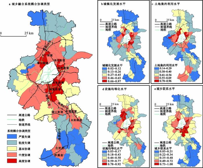
The traditional urban-rural integration level measurement research is less involved inside the administrative units of cities and counties, leading to a lack of more refined cognition of urban-rural relations. For metropolis areas, the spatial development model of central urban areas and suburbs also needs to be further analyzed. This paper uses muti-source data to innovate the ideas and methods of measuring urban-rural integration level in metropolis, and construct an evaluation system composed of urban development level, land intensive level, facility equalization level and urban-rural connection level. Based on this, we carry out the quantitatively evaluation by coupling coordination degree and bisecting K-means clustering algorithm, and the metropolis Nanjing is taken as the empirical analysis object. The results of analysis show that, firstly, the spatial distribution of the coupling coordination degree of the urban-rural integration system in Nanjing presents a cobweb structure with both circle diffusion and pole-axis diffusion type. Secondly, the distribution characteristics of the development level of each subsystem is different to some extent. Among them, the extensive use of land and the shortcomings of facility are the key factors restricting the further improvement of the coordinated development areas. The areas with unbalanced development are mostly limited by the traffic location and have relatively weak urban-rural connection, thus the development motivation is insufficient. Thirdly, the clustering characteristics of different indexes are obvious, showing four levels of urban area, urban fringe, small town and rural area and with nine types. The urban fringe level can be subdivided into three types: new town, suburb sub-city and countryside park, and the rural area level includes four types of villages: urban-radiated, sightseeing and leisure, densely populated, and remote and independent. The conclusions will provide a reference for the evaluation and spatial development strategies of urban-rural integration in metropolis.
With the prosperity of innovation-driven development, the ways to improve city innovation capability is of significant importance. Technology transfer is an important way of promoting knowledge spillovers, ensuring innovation performance and regional development. Technology transfer is not limited to the local level, multi-scale non-local technology transfer also plays an important role on innovation capability. Technology transfer is a process connected of both local and non-local connections. Therefore, this paper explores the impact and mechanisms of technology transfer network on urban innovation capability from a multi-scale perspective. In this paper, we conduct the analysis from three geographic scales, namely cities, provinces and countries. We use the number of licensed patents to indicate the innovation capacity of one city. We further construct a negative binomial regression model to empirically test the multi-scale impacts. The results show that 1) The spatial distribution of technology transfer intensity in China is unbalanced. The technology transfer network displays hierarchical distribution at both provincial and city scale. 2) At the national scale, the network centralization of the whole industry is relatively high. There are differences among different industries. At the provincial scale, different provinces display different network morphology and has various structural characteristics. 3) The regression results show that both local and non-local technology transfer can improve urban innovation capability With the scale increases, the promoting effect changes: the city scale has the strongest effect, followed by the national scale, while the provincial scale comes the last. It shows that geographic proximity has a significant promoting effect on innovation, considering local technology transfer is stronger than non-local one. The complexity of knowledge affects innovation. The higher the complexity of knowledge is, the more beneficial it is to the urban innovation capability. Our results are of great significance for clarifying the impact of multi-scale linkages on city innovation capability. And it's also beneficial for regional coordinated development and urban construction design, and for promoting and implementing China's innovation-driven development strategy.
At present, the world is stepping into the era of geopolitics of science and technology (S&T) during the process of S&T globalization, S&T change and S&T game among big powers. The competition and cooperation of global S&T is not only the main theme of the era of geopolitics of S&T, but also the dominant form of the game among big powers. Starting from the reality of global competition and cooperation of S&T, this paper clarifies the importance of China's revising or reconstructing its own geopolitical S&T strategy in the era of geopolitics of S&T, and holds that China needs to strengthen the research of geopolitics of science and technology in order to cope with the changes of international and domestic situations and ensure national S&T security. Secondly, from the perspective of the changes of the times and the evolution of geopolitical theory, it explains the reason why the research on geopolitics of S&T urgently needs to construct a new theoretical system and analysis paradigm. On this basis, this article systematically sorts out the main progress and existing problems in the geopolitics of S&T in the fields of geography, politics, and science and technology management. The findings are as follows. Although the geopolitical exploration of S&T in the field of geography has thoroughly revealed the temporal and spatial characteristics of global S&T competition and cooperation, it has not seen the nature of the national S&T power struggle from the appearance of global S&T competition. Although the geopolitical exploration of S&T in the political science field has been traced in detail the relationship between S&T progress and the evolution of geopolitical theory and the evolution of geopolitical patterns, its abstract thinking of stripping away space cannot explain the reality of the country's game around a certain geographic space. Although the geopolitical exploration of S&T in the field of S&T management has carried out a systematic research on the evolution and governance of the global S&T system, its research standpoint ignores the nature of the competition and cooperation of S&T among major powers. In view of this, this article is based on geography and puts forward the main endeavors of Chinese geography in the research of geopolitics of S&T in the future.
Digital technologies nowadays have a significant influence on shaping the innovation process and regional development. Existing research has described the nature and characteristics of the digital entrepreneurship ecosystem (DEE), focusing on firm-level characteristics; however, the interaction between the external environment and DEE is primarily undertheorized. This study thus proposes a definition of DEE by highlighting spatial impacts from the geographical perspective. A descriptive framework is then constructed to identify the distinguished genes of DEE. Five dimensions of digital entrepreneurial actors, digital users, multilateral digital platforms, digital infrastructures, and the external context are discussed. The objective is to explore the categories and ways of digital technology embedding into various actors in the entrepreneurial process, as well as the spatial pattern, processes and mechanisms of the system composed of the new elements with digitalization as the core. The main contribution of this study is providing new light on the complexity of DEE from a multi-scale perspective and exploring the pivotal role of DEE in regional development and its spatial impacts. Based on the Chinese context, the article discusses a research agenda for future studies, which provides a new theoretical perspective for entrepreneurship research in geography and practical guidelines for guiding the development of entrepreneurship in China.
Effectively promoting green innovation is of great significance to improving the high quality of China's economy. Based on the panel data of 266 prefecture-level and above cities in China from 2005 to 2019, this paper uses the SBM-DEA model to evaluate the level of green innovation and describe the spatio-temporal evolution of urban green innovation. Finally, a spatial Durbin model is constructed to empirically analyze the spatial spillover effect of urban green innovation from the perspective of different types of environmental regulation. The empirical results show that: 1) In terms of time sequence development, from 2005 to 2019, urban green innovation showed an upward trend of ''double M'' fluctuations, with great growth potential on the whole. The growth rate of green innovation level in the eastern region is relatively fast, while the growth rate in the central region, the western region, and the northeast region are relatively stable. 2) In terms of spatial evolution, urban green innovation shows strong spatial agglomeration characteristics, and the agglomeration intensity is on the rise. There is obvious regional heterogeneity in the spatial distribution pattern, and the overall performance is the development characteristics dominated by the eastern region. 3) Different types of environmental regulations have different effects on the spatial spillover effect of urban green innovation. Formal environmental regulation is not only conducive to the green innovation of local cities but also promotes the improvement of the green innovation level of neighboring cities. Informal environmental regulation can promote green innovation in local cities but has no significant impact on green innovation in neighboring cities. According to the research results, this paper puts forward policy suggestions to promote the improvement of the urban green innovation level in China from the perspective of environmental regulation. First, increase environmental protection subsidies and encourage enterprises to innovate. Second, we should reasonably design environmental policies to prevent pollution transfer. Third, give full play to public power and promote coordinated governance.
The degree of exploration of the research paradigm of Cultural Geography is related to the depth of the discipline construction of Cultural Geography, and it is also a sign of the maturity of the scientific research of Cultural Geography. Over the past 40 years of reform and opening up, China's Cultural Geography has made unprecedented achievements. But up to now, there are still debates and doubts about the research paradigm of Cultural Geography inside and outside the discipline. Starting from the ''weak paradigm'' and ''strong paradigm'' of cultural research, this paper combs and defines its connotation, analyzes the research paradigm of Chinese Cultural Geography, and holds that traditional Cultural Geography and new Cultural Geography are essentially in line with the ''weak paradigm'' and ''strong paradigm'' of cultural research. In practice, although each paradigm has triggered controversy, there are also internal tensions and extension possibilities, which should not be regarded as the ''dating'' of the paradigm. It is more practical to understand it based on ''paradigm selection'' and ''interpretation efficiency''. In the context of today's mobility and cultural hybridity, the traditional split single paradigm thinking can not better respond to the new connotation of the development of Cultural Geography. The exploration of Cultural Geography paradigm should be a dynamic process that needs to continuously establish the academic discourse power. Exploring the ''hybrid and integrated'' paradigm under the ''comprehensive perspective of time and space'' is more in line with the demands of the new era. The study calls on the future Chinese Cultural Geography community to go beyond the inertial thinking of ''paradigm division'' and ''phased peace seeking'', reposition and accurately grasp the era mission and academic commitment of Cultural Geography, improve the interpretation ability of Cultural Geography paradigm, and endow cultural geography paradigm with new connotation.
In the era of knowledge economy, the importance of talents has risen to the height of national strategy. All cities have issued talent policies, which not only attract but also retain talents. Talents' settlement has a strong impact on the development of cities and even countries. Based on the dynamic monitoring data of the migrant population in 2017, this article demonstrates the spatial distribution pattern of migrant talents' settlement at the city scale using the ArcGIS spatial analysis method. Moreover, with two multinomial Logistic regression models, the determinants of settlement intention and actual settlement duration of talents are explored. The results reveal that: 1) There are some north-south disparities and obvious regional agglomeration in the spatial distribution pattern of talent migrants' settlement. 2) There is a significant difference between the settlement intention and actual settlement of talents. Although a large number of talents stay in the city for a short time, most of them have the desire to stay for a long time. 3) As the subjective settlement intention and objective settlement duration of talents increase, the impact of amenities on talents' settlement increase. 4) The differences in the main factors affecting long-term settlement intention and actual settlement of talents are remarkable. The talents' characteristics have stronger effects on long-term settlement intention of talents, whereas the effect of urban factors on the long-term actual settlement of talents is relatively stronger. Therefore, we suggest that local governments should improve various amenities such as primary and secondary schools, green spaces, libraries and social tolerance, so as to effectively promote the long-term settlement of talents.
This article selects the population flow frequency data of 11 urban agglomerations from 2015 to 2018, uses complex network analysis and QAP analysis method to study the spatial pattern and evolution of population flow among and within urban agglomerations at different stages of development, and further analyzes the influencing factors. The main conclusions are as follows: 1) The spatial network of population flow among urban agglomerations shows obvious ''diamond'' structure, while the internal structure of urban agglomerations forms different abundance of ''pyramid'' structure. The urban agglomeration in the optimization and upgrading stage is the main area of population flow. The spatial network structure of population flow within and between urban agglomerations is more complex than the other two stages. 2) The spatial pattern of population flow is relatively stable, and the ''Hu Huanyong line'' is the dividing line of the total population flow. Under the effect of urban agglomeration in the optimization and upgrading stage, the total frequency of population flow in the eastern urban agglomeration is much larger than that in the central and western regions, showing a stable ''dense east and sparse west'' structure. 3) The spatial network of population flow in urban agglomerations shows the characteristics of small world, forming an obvious ''cohesive subgroup'' with adjacent cities as the main body. 4) There are differences in the influencing factors of the spatial network of population flow in urban agglomerations, and the level of comfort has gradually become an important driving factor for population flow. The per capita green space area, the proportion of unemployment insurance participants in the total population, the per capita road area, the per capita patent authorization and the annual average temperature have played a significant role in the formation of the spatial network of population flow in multiple urban agglomerations. The average wage of on-the-job workers has a heterogeneous impact on the population flow of different urban agglomerations.
This paper first composed the scientific definition of urban-rural logistics network from the spatial perspective, then analyzed the elements of urban-rural logistics network with reference to the basic framework of spatial structure theory and the corresponding functional characteristics of each element. The results are as follows: 1) In this paper, urban-rural logistics network is defined as an integrated spatial network that promotes the efficient flow of factors within the urban-rural geographical scope with multi-directional connecting channels and multi-level logistics nodes as the basic carrier in the process of urban-rural integration. It is also argued that urban-rural logistics network is a novel form of logistics organization in the stage of urban-rural integration. The essence of urban-rural logistics network includes the spatial extension, convergence and efficiency improvement of the existing urban logistics network and rural logistics network. 2) From the spatial perspective, the elements of urban-rural logistics network can be decomposed into three elements: node, connection and domain surface. It is pointed out that each element of the network has experienced functional strengthening and renewal. For example, the management and economic function of nodes has been strengthened in urban-rural logistics network. Besides that, the link and balance functions of linkage appeared, and the organize and adjust functions of domain surface are highlighted. 3) Following the scientific logic of “pattern-process-mechanism-decision” in geography, the analysis framework of urban-rural logistics network from spatial perspective is proposed to establish the structure of urban-rural logistics network and its evolution mechanism. Finally, our research pointed out that we should further to explore the regional types, regional suitability and interaction mechanisms of urban-rural logistics elements, and refine spatial organization models of multi-scale region, so as to strengthen the scientific knowledge of urban-rural logistics systems and scientifically support the practice of urban-rural integration.
Using the data of provincial carbon budget from 1999 to 2017, a spatial econometric model has constructed to examine the key factors affecting the fairness of carbon degree, The results show: 1) Although the carbon emissions equity of most provinces shows an overall upward trend, regional differences still existed. Among them, the carbon emissions equity in the western region is generally higher than the central region; the central region is significantly higher than the eastern region; 2) China's provincial carbon emissions equity has obvious spatial spillover effect: at the national level, the industrial structure, the level of economic development and environmental regulation are the main factors that restrain its development, and the technological progress is the main factor that promotes its promotion. At the regional level, the industrial structure, the urbanization process, the technological innovation and the degree of opening have the most obvious spillover effects on the equity of carbon emissions in the eastern provinces (municipalities and autonomous regions). The level of economic development and the technological innovation of the provinces (municipalities and autonomous regions) in the central region have a relatively significant positive spatial spillover effect on the equity of carbon emissions in the surrounding areas. The level of economic development, the degree of opening up and environmental regulation are the main factors restricting the improvement and spillover of the equity of carbon emissions in the provinces (municipalities and autonomous regions) in the western region.
This paper takes the county where the Great Wall is located in Hebei Province from 2015 to 2019 as the research point. By measuring the level of tourism industry agglomeration in the counties, it summarizes the current situation of tourism agglomeration in the counties and uses exploratory spatial data to explore the regional differentiation of GDP per capita. The spatial spillover effect of the externality of county tourism industry agglomeration on economic growth is analyzed by using spatial econometric model. It is conducive to the cooperation and competition of tourism economic activities among counties. Secondly, the paper is promoting the establishment of the joint mechanism of protection and development of the Great Wall, and promoting the improvement of local economic level. The results as follows: 1) The differences of tourism agglomeration in counties where the Great Wall is located in Hebei Province show a convergence trend on the whole. 2) GDP per capita has a significant positive spatial correlation. The spatial agglomeration degree generally shows a steady and decreasing trend. It gradually develops equally. 3) There is a significant positive spatial spillover effect of GDP per capita among counties. Tourism agglomeration has a significant positive effect and becomes an important factor affecting GDP per capita. The differences of tourism agglomeration in counties where the Great Wall is located in Hebei province show a convergence trend on the whole. It shows that the agglomeration degree of tourism industry has not changed and improved significantly. However, the tourism development pattern has gradually changed from extremely unbalanced to balanced. Local spatial agglomeration of per capita GDP is obvious. The counties of high-high concentration areas and low-low concentration areas, low-high or high-low concentration areas changed slightly over time. It is mainly distributed in the northern and central areas of Hebei Province where the Great Wall is located, forming a local spatial club pattern. The agglomeration of cultural resources of the Great Wall will have certain influence on economic growth. The agglomeration effect of tourism in neighboring areas will have a positive impact on this region. Government input and road network density have significant positive effects on control variables.
Water resources are the most rigid constraint for ecological protection and high-quality development in the Yellow River Basin. This paper first measures the changes of water footprint of the Yellow River basin from a structural perspective, and then analyzes the decoupling of water footprint and economic growth based on Tapio decoupling model and Kaya-LMDI decomposition model, and identifies the driving factors of water resources utilization change from the technical effect, structural effect, scale effect, endowment effect, urbanization effect and population effect. We found that: 1) the water footprint of the Yellow River basin is on the rise, the proportion of agricultural water footprint is as high as 85%, and the upside down problem of water structure and industrial structure is prominent; 2) The spatial distribution of water resource and water footprint does not match in the upper and lower reaches of the Yellow River basin, and the middle and lower reaches face more serious water resources restriction. 3) The relationship between water footprint and economic growth is mainly weak decoupling, but the provinces began to shift to strong decoupling in the period of 2015-2019. 4) Scale effect, urbanization effect, and population effect play a role in pulling water footprint changes, while technological effect, structural effect, and endowment effect play an inhibitory role in water footprint changes, but there is still potential for improvement. There are certain differences in influencing factors in different provinces and regions. Therefore, it is necessary to strengthen the research and extension of water resources utilization technology, promote the intensive development of agriculture, improve the efficiency of agricultural water use, further optimize the industrial structure and new urbanization construction, alleviate the dilemma of water resources constraints, and promote the high-quality economic development of the Yellow River Basin.
Chinese cities need to advance sustainable energy consumption and ensure carbon emission peak and carbon neutrality. The research topic of this paper is the relationship between urban growth in a Chinese plateau city and the factors driving households to consume different kinds of household energy and their carbon emissions. We select Xining, a plateau city in Qinghai, as the research object, conduct household energy consumption questionnaire household surveys, establish a plateau city household energy consumption database (N=500), and use spatial data analysis methods to analyze household energy consumption and carbon emissions. We found that: 1) The per capita energy consumption and per capita carbon emissions of households in Xining, a plateau city, are 10.57 kgce/d and 6.11 kg/d, respectively, heating, kitchen equipment, and water heater equipment are the main sources. What is more, the per capita energy consumption of Xining is 18 times that of Guangzhou (0.58 kgce/d), a global super city economy. However, the proportion of energy consumption of large household appliances in Xining is lower than that in Guangzhou, because Guangzhou households pay more attention to energy efficiency when purchasing household appliances and are more willing to buy energy-efficient products; 2) The carbon emission per capita household energy consumption in Xining City generally shows a relative concentration of high-value areas (HH) and low-value areas (LL), and there are also high and low-value areas in some areas. high and low-value areas (HL) and low- and high-value areas (LH) agglomeration phenomenon and its spatial law present obvious heterogeneity; 3) Factors such as household income, geographical environment, and building characteristics are the formation of spatial heterogeneity of per capita household energy consumption carbon emissions. We observe the diversity of energy transition by comparing the patterns of carbon emission from household energy consumption within the city. Then, a comprehensive picture of the diversity underlying the energy transition applied across cases can be distilled.
Modern gully agriculture is a new regional type of agriculture developed in the process of man-land coupling in the loess hilly and gully legion. Its sustainable development has great practical significance for the high-quality development of regional agriculture, optimization of "production-living-ecological" space and rural revitalization. Based on the cognition of human-earth system science, the connotation, sustainable development direction, typical development patterns and guarantee system of modern gully agriculture were discussed, and relevant research prospects were proposed. This paper also provides a theoretical reference for systematically understanding the patterns of gully agriculture and promoting its sustainable development in loess hilly and gully region. The conclusions are as follows: 1) Gully agriculture is an important functional type of rural regional system, which has the characteristics of multi-scale and multi-level. Thus, the sustainable development of gully agriculture should focus on micro, meso and macro scales to realize the sustainable development of soil ecosystem, farmland ecosystem and agricultural regional system synergistically. 2) On the premise of ensuring food security and ecological security, adjustment of agricultural structure should be actively promoted to develop multifunctional agriculture. Through the "3C" model, namely, the internal circulation of agriculture itself, external circulation of agriculture and the big circulation of agriculture based on agricultural multifunction, it helps to realize the optimization of the production structure, the extension of the industrial chain and the complementarity of urban and rural functions, which can promote the development of rural economy and urban-rural integration. 3) Innovation and promotion of the driving patterns such as comprehensive land consolidation pattern, agricultural structure adjustment pattern, comprehensive development of characteristic resources pattern and land transfer scale production pattern can help to improve the efficiency and quality of agricultural production. 4) The furture is expand interdisciplinary research of geography and other disciplines, and deepen the research in "theory-practice" paradigm. To explore and establish the agricultural production guarantee system that integrates technology research and application, talent training, policy and institutional support, are the important measure to comprehensively improve the efficiency of agricultural resources utilization and overall production efficiency of gully agriculture and promote the modernization of gully agriculture.
To explore the status of coupled coordination between carbon emissions and vegetation sequestration, the spatial and temporal variation characteristics and drivers of coupled coordination between carbon emissions and vegetation sequestration in the Yangtze River Delta (YRD) from 2005 to 2017 were analyzed by constructing an evaluation index system and analytical framework, using the integrated index method, coupled coordination degree model and gray correlation degree model, and simulating the influence of government decision priorities on the trend of coupled coordination degree. The results show that the YRD has significant spatial agglomeration characteristics of carbon emissions, basically forming a high-emission belt along the Yangtze River and the southeastern coastal areas of the YRD. The coupling coordination degree of carbon emission and vegetation carbon sequestration has obvious spatially divergent characteristics, showing the characteristics of a circle structure with the general dysfunctional area along Nanjing-Shanghai as the core. The coupling coordination degree is generally higher in the areas where the comprehensive evaluation value of vegetation cover is higher than the comprehensive evaluation value of carbon emission, and the concentration and change of population, urban construction and energy consumption have the greatest influence on the coupling coordination degree. Meanwhile, the priority of government decisions significantly affects the coupling coordination trend. The study can provide feasible references for regional sustainable development and government development model selection. According to the research results of coupling coordination and the analysis of influencing factors, this paper puts forward policy suggestions on the coordination of economic development and ecological environmental protection in the YRD from the aspects of land use structure, industrial development, technological progress and regional coordination. The first is to optimize the spatial structure of regional land use and form a new pattern of efficient development. The second is to promote regional ecological co-protection and governance, and build a new barrier for ecological security. The third is to tap the potential of regional industrial synergy and consolidate the new advantages of innovation and cooperation. The fourth is to strengthen the research and development of green and low-carbon technologies to stimulate new momentum for green development.
With the continuous advancement of industrialization and the rapid development of urbanization, China's environmental pollution is becoming cumulatively serious, which has attracted extensive attention from all walks of life. Selecting the 286 major prefecture-level cities in China as the study area, using the raster data of the average annual PM2.5 mass concentration in Chinese prefecture-level cities from 2003 to 2016 provided by the Atmospheric Composition Analysis Group at Dalhousie University in Canada, and employing the methods in spatial autocorrelation and Spatial Durbin Model, this paper reveals the spatio-temporal evolution patterns and driving factors of PM2.5 mass concentration in Chinese prefecture-level cities from 2003 to 2016. The main findings are as follows: 1) The temporal evolution of PM2.5 pollution in China shows an "M-shaped" fluctuation trend, the average annual mass concentration of PM2.5 in China increased first, then decreased and then increased again from 2003 to 2016. And the spatial distribution of PM2.5 pollution in China shows an agglomeration pattern of "high in the east and low in the west" with Hu Line as the boundary. The seriously polluted area is concentrated in the densely populated and economically developed area on the southeast side of the line, while the overall pollution is light on the northwest side. 2) The spatial effect of PM2.5 pollution in prefecture-level cities in China shows a significant positive correlation. Globally, Moran's I of PM2.5 mass concentration in China's prefecture-level cities was higher than 0.700 from 2003 to 2016. Locally, most cities in Moran scatter plot are located in the first and third quadrants, which more intuitively reflects the positive correlation of PM2.5 mass concentration among prefecture-level cities. 3) Population density and the proportion of non-agricultural workers are the main factors contributing to the aggravation of PM2.5 pollution in China, while the total supply of liquefied petroleum gas and the proportion of tertiary industry in GDP have a significant negative reduction effect on PM2.5 pollution. Therefore, the environmental problems caused by the current over-concentration of population and unbalanced urbanization development need to be solved urgently. The urban and industrial structure should be optimized and the urbanization process should be improved in the future. While maintaining stable economic growth, the resource-saving and environment-friendly society should be gradually established, so as to promote the early "separation" between economic development and environmental pollution. This article explores the internal spatial correlation of air pollution in China from the macro perspective of global pollution joint prevention and control. The key influencing factors of PM2.5 pollution are further explored in order to provide suggestions for air pollution control in China.
Due to cold waves, some regions of the southern China experience low or even extremely low temperatures in winter. When the temperature drops sharply, it may cause severe low temperatures, rain/snow and freezing disasters. These disasters seriously affect transportation, power safety, and other social production activities. This study used the precipitation and average temperature data from 258 stations in 12 provinces of the southern China between 1951 to 2020 to extract the low temperature events and screen the characteristic indexes, which were negative accumulated temperature, accumulated precipitation and daily maximum precipitation. The index values of different return periods (RP=5, 10, 30, 50 a) were calculated to assess the hazard of low-temperature rain, snow, and freezing events accordingly. Combined with the distribution of highway and railway networks, the exposure of traffic lines was analyzed. The results showed that the areas with more events were concentrated in Guizhou, Hubei, Anhui, and Jiangsu. The duration was in a zonal distribution, and the boundaries of high-value areas were clear. Among them, the longer duration areas were in Guizhou and Hunan. The maximum value of negative accumulated temperature was -78.2℃, the maximum value of accumulated precipitation was 83.2 mm, and the maximum value of daily precipitation was 38.9 mm (RP=50 a). Hubei, Hunan, Guizhou, Anhui and Jiangxi were high risk areas, and the above-mentioned areas all had road sections with high risk.
Geographically weighted regression (GWR), principal component geographically weighted regression (PCA-GWR) and mixed geographically weighted regression (M-GWR) were used to model and map the spatial distribution of soil pH in Anhui Province. Based on the soil pH data from 140 sampling sites in Anhui Province, and the effects of macroscopic factors such as soil, topography, climate and biology on soil pH were also taken into consideration. And then, the spatial distribution characteristics of the effects of environmental factors on soil pH were explored. Finally the accuracy of three GWR models was compared based on multiple linear regression model (MLR). The results showed that: Soil pH in Anhui Province has spatial heterogeneity and obvious agglomeration characteristics. Among the three GWR models, the M-GWR model is slightly better, and the modeling sets Radj2 of GWR, PCA-GWR and M-GWR are 0.59, 0.62 and 0.63, respectively. Compared with the MLR model, the Radj2 of the three GWR models increases by 23%, 31% and 35%, respectively. The prediction map generated by M-GWR is smooth in space, and the modeling effect is stable. The prediction results show that the area north of the Huaihe River in Anhui Province is mostly alkaline soil, and the south of the Yangtze River is mostly neutral or acidic soil, which accords with the characteristics of "southern acid and northern alkali". The results show that GWR and its improved model can effectively predict soil pH attributes and reflect the influence of environmental factors on soil pH in different spatial locations, while M-GWR has both global and local effects of variables, which improves the interpretation ability of the model and provides an important reference method for digital soil mapping in large areas.