
城际“1小时交通圈”地学定量研究——以上海主城区为例
作者简介:黄 翌(1985-),男,江苏南通人,博士研究生,主要从事资源环境信息与空间决策研究。E-mail:315797091@qq.com
收稿日期: 2012-03-13
要求修回日期: 2012-06-19
网络出版日期: 2013-02-20
基金资助
国家自然科学基金项目(41171118、71103182)、江苏省普通高校研究生科研创新计划项目(CXZZ12_0942)、江苏高校优势学科建设工程项目(SZBF2011-6-B35)资助
Geoscience Quantitative Research on Intercity “One Hour Traffic Circle”——A Case of Shanghai Main City
Received date: 2012-03-13
Request revised date: 2012-06-19
Online published: 2013-02-20
Copyright
“1小时交通圈”是近年来区域交通建设和经济发展领域较热门的概念,在主要中心城市周边,很多城镇都提出了融入其1小时交通圈的战略规划。通过对交通圈进行分类,界定了研究要素,以长三角地区公路和铁路为道路网络数据集,定量研究了上海市城际1小时交通圈道路的设计方法、建立方法和构面方法。根据交通规划预测了2020年交通圈的扩散范围,并分析了上海市主城区对外1小时交通圈的性质及内部结构,根据不同交通工具的速度和特征将交通圈分成商务圈、大众圈、货运圈和高铁圈等类型,最终总结出交通圈发育结构。研究结果表明:① 2011年,上海市1小时交通圈可以覆盖到周边10个地市的部分区域,并随着交通设施的完善不断接近“圈层-环点”交通圈结构。② 通过分析1小时交通圈中的“岛”,能够了解到路网完善程度和存在的问题,辅助道路规划。③ 对交通圈进行分层研究能够更好地通过交通圈对圈内的人流和物流进行分析。④ “圈层-环点”状的现代中心城市城际交通圈结构能够检验中心城市周边路网建设所处的阶段,以及为城市、区域等相关领域的经济圈、都市圈研究打下交通基础。
黄翌 , 李陈 , 欧向军 , 汪云甲 , 李效顺 . 城际“1小时交通圈”地学定量研究——以上海主城区为例[J]. 地理科学, 2013 , 33(2) : 157 -166 . DOI: 10.13249/j.cnki.sgs.2013.02.157
"One hour traffic circle" is a popular concept in regional traffic construction and economic development. Recent years, many cities and towns have put forward strategic planning to get into one hour traffic circle of the regional center city around them. In this paper, the concept of traffic circle is classified firstly, then, the research elements are defined, based on the highway and railway network dataset in Yangtze River Delta, the design method, construction method and structure method for one hour traffic circle of Shanghai city are quantitatively studied. And on the basis of these methods and data, one hour traffic circle of Shanghai city in the end of 2011 is calculated. According to the traffic planning to 2020, the diffusion area of traffic circle is predicted, and the properties and internal structure of one hour traffic circle of the main in Shanghai are analyzed. Then, the traffic circle is divided into business circle, public circle, freight circle, and high speed railway circle according to the different vehicle speed and characteristics. Finally, the traffic circle model is summarized. The results show that: 1, in the end of 2011, one hour traffic circle of Shanghai City can cover part of the around 10 cities, and with the improvement of transportation facilities, the circle will be more and more close to the "circle & surrounding point model". 2, the degree of perfection and existing problems of road nets can be defected through analyzing the" islands" in a traffic circle, which can assist road planning. 3, through classification of the traffic circle, people flow and material flow in the circle can be analyzed better. 4, Circle & surrounding point structure can inspect the period of road network construction around center city, and provide basis for studying economic circle, and metropolitan area in city and regional science.
Fig.1 Designing experiment of road traffic circle图1 道路交通圈生成设计实验 |
Fig.2 120 km traffic map aruond main city of Shanghai图2 上海主城区周边120 km内的交通图 |
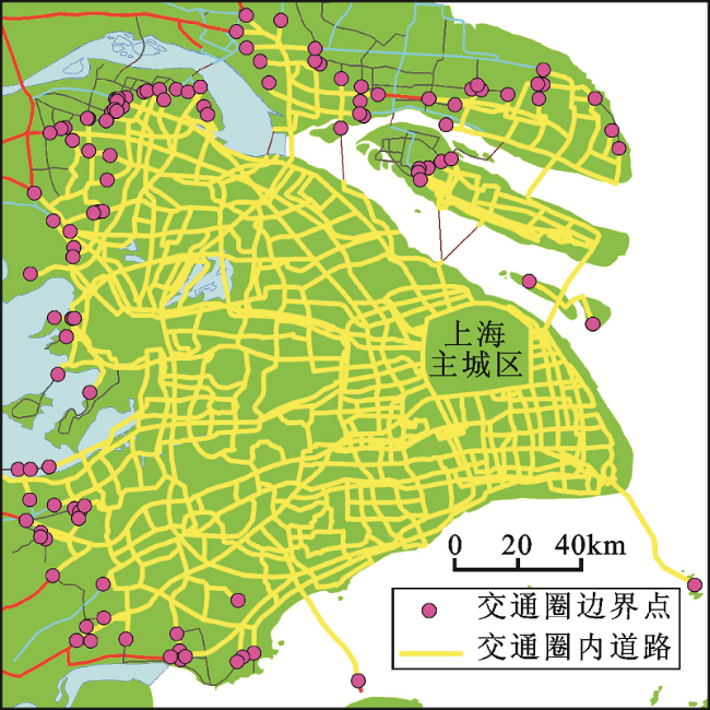
Fig.3 Boundary point of one hour traffic circle of main city of shanghai图3 上海主城区城际1小时交通圈边界点 |
Fig.4 Loop图4 回路 |
Fig.5 One hour road traffic circle of main city of Shanghai(based on administration method and town scale)图5 上海主城区公路1小时城际交通圈(基于行政区划法,镇域尺度) |
Fig.6 One hour traffic circle of main city of Shanghai(based on town scale)图6 镇域尺度的上海市主城区1小时交通圈 |
Table 1 Towns and districts in one hour traffic circle of main city of Shanghai表1 上海主城区城际1小时交通圈内的镇级行政单元统计 |
| 城市 | 区、县、县级市 | 位于上海主城区城际一小时交通圈内的镇级行政单元(2011年12月) |
|---|---|---|
| 上海市 | 除崇明县三星镇、绿华镇、新村乡以外的全部镇级行政单元 | |
| 苏州市 | 除吴中区金庭镇、东山镇、张家港市金港镇、大新镇以外全部镇级行政单元 | |
| 无锡市 | 江阴市 | 周庄镇、华士镇、祝塘镇、长泾镇、顾山镇、新桥镇 |
| 惠山区 | 洛社镇 | |
| 滨湖区 | 除胡埭镇、马山街、雪浪街以外的全部镇级行政单元 | |
| 其他 | 南长区、北塘区、崇安区、锡山区的全部镇级行政单元 | |
| 常州市 | 新北区 | 新桥镇 |
| 其他 | 天宁区、钟楼区、戚墅堰区的全部镇级行政单元 | |
| 镇江市 | 丹徒区谷阳镇、丹阳市云阳镇 | |
| 南通市 | 启东市 | 除启隆乡以外的全部镇级行政单元 |
| 通州区 | 先锋镇、张芝山镇、川江镇、金沙镇、四安镇、兴东镇、兴仁镇 | |
| 海门市 | 海门镇、江心沙农场、三星镇、德胜镇、三阳镇、临江镇、悦来镇、三厂镇、万年镇 | |
| 其他 | 崇川区、港闸区、开发区的全部镇级行政单元 | |
| 嘉兴市 | 海宁市 | 除周王庙镇、黄湾镇以外的镇级行政单元 |
| 桐乡市 | 梧桐街道、乌镇镇、濮院镇、崇福镇、高桥镇、屠甸镇、凤鸣镇 | |
| 其他 | 南湖区、秀洲区、嘉善县、平湖市、海盐市的全部镇级行政单元 | |
| 湖州市 | 南浔区 | 南浔镇、练市镇、双林镇、旧馆镇 |
| 吴兴区 | 八里店镇、织里镇 | |
| 杭州市 | 拱墅区、上城区、下城区、江干区、西湖区的街道 | |
| 舟山市 | 嵊泗县 | 洋山镇 |
Table 2 Area statistic of one hour traffic circle of main city of Shanghai for each city表2 各市位于上海主城区1小时交通圈内的面积统计 |
| 上海市 | 苏州市 | 嘉兴市 | 南通市 | 无锡市 | 湖州市 | 杭州市 | 镇江市 | 常州市 | 舟山市 | |
|---|---|---|---|---|---|---|---|---|---|---|
| 面积 (km2) | 5750.54 | 5725.38 | 3249.05 | 2215.06 | 1147.28 | 558.82 | 272.97 | 188.86 | 180.24 | 13.64 |
| 比例 | 90.70% | 84.31% | 82.99% | 25.93% | 30.29% | 9.61% | 1.64% | 4.91% | 4.11% | 0.95% |
Fig.7 Classification of one hour traffic circle of main city of Shanghai图7 上海市主城区城际1小时交通圈类型图 |
Fig.8 Prediction of one hour traffic circle of main city of Shanghai in 2020图8 2020年上海市主城区城际1小时交通圈预测 |
Fig.9 The traffic circle structure of modern central city with mature external transportation facilities图9 对外交通发育完备的现代中心城市交通圈结构 |
The authors have declared that no competing interests exist.
| [1] |
全国科学技术名词审定委员会.交通圈的定义[OL].
|
| [2] |
|
| [3] |
|
| [4] |
|
| [5] |
|
| [6] |
|
| [7] |
|
| [8] |
|
| [9] |
|
| [10] |
|
| [11] |
|
| [12] |
O’SullivanD, MorrisonA, ShearerJ. Using desktop GIS for the Investigation of Accessibility by public Transport : an lsochrone approach[J].International Journal of Geographical Information Scienee,2000(l):85-104.
|
| [13] |
|
| [14] |
|
| [15] |
|
| [16] |
|
| [17] |
|
| [18] |
|
| [19] |
|
| [20] |
|
| [21] |
|
| [22] |
|
| [23] |
|
| [24] |
中华人民共和国交通部.公路工程技术标准[S].中华人民共和国行业标准(JTGB01-2003).
|
| [25] |
|
| [26] |
中国铁路客户服务中心[OL].
|
| [27] |
|
| [28] |
|
| [29] |
|
| [30] |
|
| [31] |
|
| [32] |
|
| [33] |
|
| [34] |
|
/
| 〈 |
|
〉 |


