
一次东北冷涡暴雨的水汽输送特征和位涡分析
作者简介:王宁(1966-),女,吉林永吉人,高级工程师,主要从事灾害性天气预报及环境气象预报方法研究。E-mail:wangningwell@126.com
收稿日期: 2013-01-25
要求修回日期: 2013-06-21
网络出版日期: 2014-02-10
基金资助
公益性行业(气象)科研专项(GYHY201006006、GYHY200906011)、中国气象科学研究院灾害天气国家重点实验室开放课题(201109)和中国气象局预报员专项(CMAYBY2011-009)资助
Water Vapor Transport Features and Potential Vorticity Analysis of A Northeast Cold Vortex Rainstorm
Received date: 2013-01-25
Request revised date: 2013-06-21
Online published: 2014-02-10
Copyright
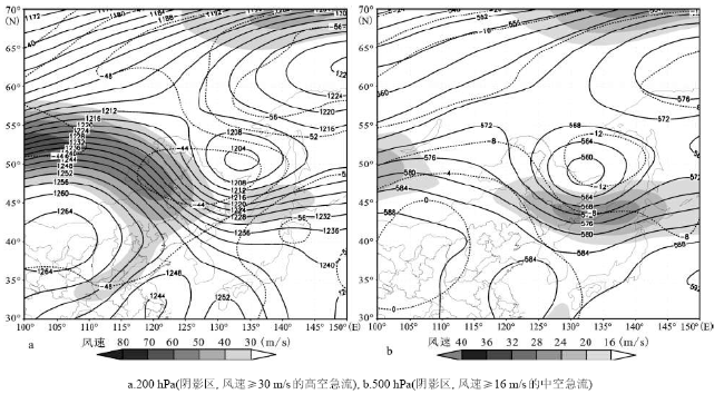
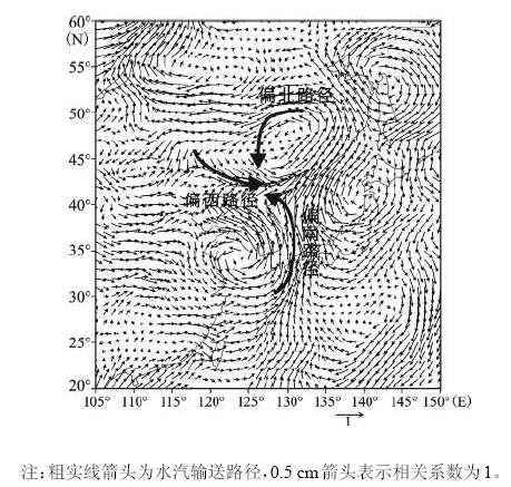
通过对2010年7月27~29日吉林省一次较大范围的冷涡暴雨、大暴雨过程进行诊断分析,建立了此类暴雨的天气概念模型:200 hPa呈现“两脊一槽”型,高空急流呈辐散状位于吉林省上空,急流中心最大风速≥60 m/s;500 hPa东北冷涡强烈发展,鄂海阻高稳定维持是此次强降水发生的重要天气系统,中心最大风速≥20 m/s的偏西风急流带横穿吉林省中部;850 hPa风速≥12 m/s的3条急流带在吉林省中东部地区交汇,形成低层辐合、高层辐散的气旋性涡度柱,较强的垂直上升气柱一直向上伸展到500 hPa附近,极有利于对流的发展和强降水的维持。通过计算整层水汽通量与吉林省逐6 h平均降水量的相关矢量场,结果表明:偏西、偏南及偏北3条水汽通道在吉林省中南部汇集是此次强降水发生的重要条件,暴雨落区与整层水汽通量汇合区密切相关,水汽输送以经向(南北方)水汽流入为主。暴雨期间具有较好的动力、热力及能量条件,特别是湿对流有效位能明显偏强,强降水出现在对流有效位能 (CAPE)值由极大值开始下降的过程中。干侵入是激发冷涡发生、发展的动力条件之一,≥1 PVU(位涡单位)的高位涡舌在下降的过程中,同时南移,与中部地区强降水落区自北向南移动相吻合。
王宁 , 徐祥德 , 徐洪雄 , 慕秀香 , 牛立强 , 李尚锋 . 一次东北冷涡暴雨的水汽输送特征和位涡分析[J]. 地理科学, 2014 , 34(2) : 211 -219 . DOI: 10.13249/j.cnki.sgs.2014.02.211
Based on the diagnostic analysis of a wide range of cold vortex rainstorm and heavy rainstorm process from 27 to 29 July,2010 in Jilin Province, the conceptual model of such heavy weather was established:"two ridge and one trough" type was consisted, upper-level jet was divergent and located in Jilin Province, the central maximum of jet wind speed was≥60 m/s at 200 hPa; the strong development of northeast cold vortex and the stable maintenance of Okhotsk blocking high at 500 hPa was an important weather system of the strong precipitation, the jet zone with ≥20 m/s west wind speed crossed over the central section of Jilin Province; the three jets with ≥12 m/s wind speed at 850 hPa intersected in the middle-eastern area of Jilin Province and formed the cyclonic vorticity column of low-level convergence and upper-level divergence, the strong vertical-rising gas column had been extended upward to near 500 hPa,these were very beneficial to the maintain of convection and the development of strong precipitation. By the calculation of the correlative vector field between the whole layer of water vapor flux and 6-hour average precipitation in Jilin Province, results showed that: collection of the three water vapor channels of west, south and north in the middle-southern part of Jilin Province was an important condition for the rainstorm;the rainstorm area was highly correlated to the confluence area of vertically integrated water vapor flux; the dominant direction of water vapor transport was meridional (South and North).The rainstorm was benefited from suitable dynamic, thermal and energy conditions, especially the wet Convective Available Potential Energy(CAPE) was obviously strong and the heavy precipitation occurred when the CAPE value began to fall from the maximum. Dry intrusion was one of the dynamic conditions that stimulated the occurrence and development of cold vortex; the tongue of high potential vorticity of ≥1PVU (Potential Vorticity Unit) shifted downward vertically and moved southward at the same time, corresponding to the move of heavy precipitation area from north to south in the central region.
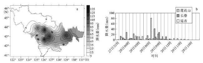
Fig.1 The precipitation distribution at 20 BT ,27-28,July 2010(mm)图1 吉林省2010年7月27~28日20时雨量分布(mm) |
Fig.2 The overlay chart of geopotential height(solid line,unit:dagpm) and temperature field(dashed line,unit:℃) at 08 BT, 28 July, 2010图2 2010年7月28日08时位势高度(实线,单位dagpm)及温度场(虚线,单位℃) |
Fig.3 The correlated vector field between vertically integrated water vapor flux and 6 h average precipitation in Jilin Province from 02 BT, 25 July to 02 BT, 1 August ,2010图3 2010年7月25日02时~8月1日02时整层水汽通量与吉林省6 h平均降水量的相关矢量场 |
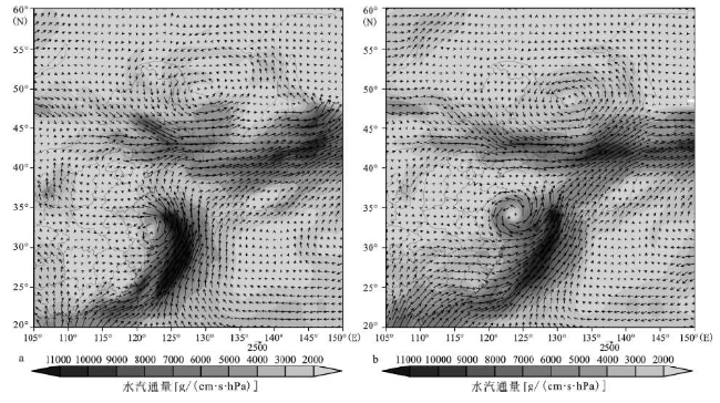
Fig.4 The vertically integrated water vapor flux at 20 BT 27 (a) and 08 BT 28 (b) July 2010 (shaded area and arrow,unit:g/(cm·s·hPa))图4 2010 年7月27日20时(a)和 28日08时(b)大气整层水汽通量(阴影及箭头表示,单位:g/(cm·s·hPa)) |
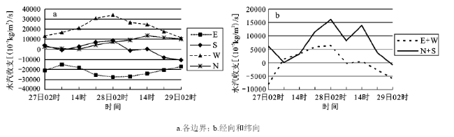
Fig.5 The time series chart of budget of the vertically integrated water vapor[10-5kg/(m2·s)]图5 整层水汽收支时间序列[10-5kg/(m2·s)] |
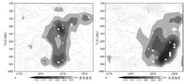
Fig.6 The meridional-vertical section of divergence(solid line, unit:10-5/s) and vertical velocity(shaded area, 10-3hPa/s) along 43°N at 20 BT 27(a) and 08 BT 28(b) ,July ,2010图6 2010年7月27日20时(a)和28日08时(b)过43°N散度(实线, 10-5/s)与垂直速度(阴影,单位:10-3hPa/s)的经向-垂直剖面 |
Table 1 Convective potential condition of rainstorm of cold vortex表1 冷涡暴雨对流潜势条件 |
| 长春 | 27日08时 | 27日20时 | 28日08时 | 28日20时 | 延吉 | 27日08时 | 27日20时 | 28日08时 | 28日20时 |
|---|---|---|---|---|---|---|---|---|---|
| CAPE(J/kg) W-CAPE(J/kg) K指数(℃) Si指数(℃) 12 h雨量(mm) | 855 41.3 18 -1.1 0 | 2073 64.4 28 5.1 38.4 | 261 22.8 36 -1.4 54.5 | 0 0 25 7.5 0 | CAPE(J/kg) W-CAPE(J/kg) K指数(℃) Si指数(℃) 12 h雨量(mm) | 765 39.1 -8 -1.6 1.8 | 475 30.8 36 0.9 75.4 | 0 0 34 1.4 24.2 | 0 0 30 2.4 0 |
注:CAPE(对流有效位能),表示自由对流高度到平衡高度之间的层结曲线与状态曲线所围成的面积,CAPE值越大,强对流天气发生的潜势越大。W-CAPE为最大上升速度;W-CAPE= CAPE1/2。K指数:K=(T850-T500)+Td850-(T-Td)700,式中第一项代表温度直减率,第二项表示低层的汽水条件,第三项反映中层的饱和程度,K值越大越有利于强降水的发生。Si(沙氏指数): Si=T500-T',T'为气块从850 hPa开始沿干绝热线上升,到达抬升凝结高度后,再沿湿绝热线上升至500 hPa时具有的温度,Si<0时,表示对流不稳定,Si>0时,表示稳定。 |
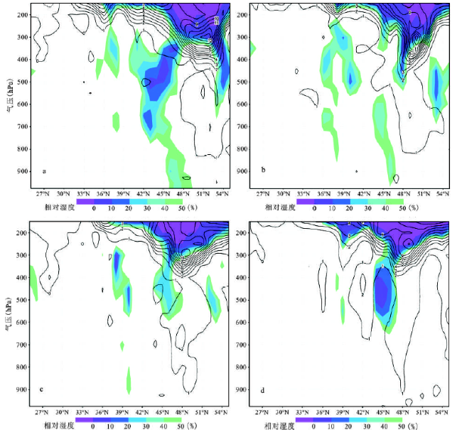
Fig.7 The zonal-vertical section of potential vorticity(solid line,unit:PVU) and relative humidity(shaded area, unit:%) along the centre of cold vortex at 08 BT 27(a) ,20 BT 27(b), 08 BT 28(c), 20 BT 28(d) July 2010图7 2010年7月27日08时(a),27日20时(b),28日08时(c),28日20时(d)沿冷涡中心位涡(实线,单位:PVU)及相对湿度≤50%(阴影区,单位:%)的纬向-垂直剖面 |
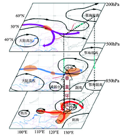
Fig.8 The conceptual model of convective heavy rainstorm of northeast cold vortex(heavy arrow is jet;shaded area is the center of maximum wind speed,V200hPa≥60 m/s;V500hPa≥20 m/s; V850hPa≥12 m/s)图8 东北冷涡对流性大暴雨的天气概念模型(粗箭头为急流带,阴影区为最大风速中心,V200hPa≥60 m/s;V500hPa≥20 m/s;V850hPa≥12m/s) |
The authors have declared that no competing interests exist.
| [1] |
|
| [2] |
|
| [3] |
|
| [4] |
|
| [5] |
|
| [6] |
|
| [7] |
|
| [8] |
|
| [9] |
|
| [10] |
|
| [11] |
|
| [12] |
|
/
| 〈 |
|
〉 |