
基于遥感数据的西藏高原自然生态系统脆弱性评估
作者简介高江波(1984-),男,山东临沂人,副研究员,硕士生导师,主要从事地表过程及其资源环境效应研究。E-mail:gaojiangbo@igsnrr.ac.cn
收稿日期: 2015-04-15
要求修回日期: 2015-07-28
网络出版日期: 2016-07-21
基金资助
国家科技支撑项目(2013BAC04B02,2012BAC19B10)、国家重点基础研究发展计划(2015CB452702)和国家自然科学基金项目(41301089)资助。
Comprehensive Assessment of Natural Ecosystem Vulnerability in Tibetan Plateau Based on Satellite-derived Datasets
Received date: 2015-04-15
Request revised date: 2015-07-28
Online published: 2016-07-21
Supported by
National Key Technology Research and Development Program (2013BAC04B02,2012BAC19B10), National Key Basic Research Program of China (2015CB452702), National Nature Sciences Foundation of China (41301089).
Copyright
基于生态系统结构、功能、生境的脆弱性评价指标体系,以MODIS为基础数据源,评估了西藏高原自然生态系统的脆弱性,并揭示其空间异质性特征。结果表明:① 分别基于气候、结构以及功能指标的西藏高原生态系统脆弱性程度空间分布呈现出相似规律,整体为从东南向西北脆弱性程度逐渐加剧的趋势;而基于地形指标的生态脆弱性则呈现相反的分布格局,说明了相对地形而言,气候因子对于西藏高原生态系统宏观分布状况更为重要;② 综合生态系统结构、功能及气候和地形生境特征对脆弱性的影响,全区呈现从东南向西北综合脆弱性水平逐渐升高的趋势,在评估区范围内综合脆弱性等级为中等及以上的地区共占74%,整体脆弱性程度较大,其中综合脆弱性等级为很高水平的地区占了45.8%。明晰西藏高原自然生态系统的脆弱性程度及其空间分布特征,可为典型脆弱生态系统的监测和综合评估提供科学依据,进而有利于青藏地区生态环境治理工作的顺利进行。
高江波 , 侯文娟 , 赵东升 , 吴绍洪 . 基于遥感数据的西藏高原自然生态系统脆弱性评估[J]. 地理科学, 2016 , 36(4) : 580 -587 . DOI: 10.13249/j.cnki.sgs.2016.04.012
The assessment index system was firstly constructed for ecosystem vulnerability from the viewpoint of ecosystem structure-function-habitat. And then, with MODIS satellite-derived datasets as the main data resource, this paper assessed the ecosystem vulnerability for Tibetan Plateau (TP) and detected its spatial heterogeneity. It is shown that the spatial patterns of TP ecosystem vulnerability, based on climatic factors, structural indices and functional indices, respectively, are consistent. The vulnerability degrees gradually increase from southeast to northwest of TP. However, the changing trend is opposite for topography-based vulnerability assessment. This indicates that compared with topography indices, including slope, relief amplitude, earth’s surface incision and roughness in elevation, climatic factors, such as monthly maximum temperature, monthly minimum temperature and drought severity index, are more important to determine the spatial pattern of ecosystem structure and function. Furthermore, taking the indices for ecosystem structure, function and habit (i.e. climate and topography) into account, both the comprehensive ecosystem vulnerability and its classification present the spatial characterization of increasing from southeast to northwest, similar to the above-mentioned trend. According to the spatial statistics in ArcGIS software, the classes higher than middle of ecosystem vulnerability accounts for 74% of evaluation area, while the very high class accounting for 45.8%, indicating the serious overall conditions for ecosystem vulnerability in TP. Identifying the ecosystem vulnerability degree and its spatial patterns can provide scientific basis for vulnerable ecosystem monitoring and comprehensive assessment, which is further helpful for ecological regulation and management in TP.
Table 1 The assessment indices for ecosystem vulnerability of Tibetan Plateau表1 西藏高原生态环境脆弱性评估指标体系 |
| 指标集 | 指标 | 数据源 | 空间分辨率 | |
|---|---|---|---|---|
| 西藏高原生态 系统脆弱性 | 生态系统结构 | 归一化植被指数NDVI | MODIS/MYD13A3 | 1 km |
| 增强型植被指数EVI | MODIS/MYD13A3 | 1 km | ||
| 叶面积指数LAI | MODIS/MCD15A2 | 1 km | ||
| 生态系统功能 | 总初级生产力GPP | MODIS/MOD17A3 | 1 km | |
| 净初级生产力NPP | MODIS/MOD17A3 | 1 km | ||
| 生态系统生境 | 最冷月均温 | MODIS/MOD11A1&ANUSPLIN | 1 km | |
| 最热月均温 | MODIS/MOD11A1&ANUSPLIN | 1 km | ||
| 干旱指数DSI | MODIS | 5 km | ||
| 坡度 | STRM/DEM | 1 km | ||
| 地表粗糙度 | STRM/DEM | 1 km | ||
| 地表切割度 | STRM/DEM | 1 km | ||
| 地表起伏度 | STRM/DEM | 1 km |
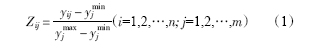

Table 2 Classification criteria of comprehensive ecosystem vulnerability index for Tibetan Plateau表2 西藏高原综合生态系统脆弱性指数分级标准 |
| 距标准差倍数 | 相当于脆弱性等级 |
|---|---|
| >1.5 | 高 |
| 0.5~1.5 | 较高 |
| 0.5~-0.5 | 中 |
| -0.5~-1.5 | 较低 |
| <-1.5 | 低 |
Fig.1 The spatial pattern of ecosystem vulnerability based on climatic(a) and topographical indices(b) in Tibetan Plateau图1 西藏高原基于气候(a)、地形指标(b)的生态系统脆弱性空间格局 |
Fig.2 The spatial pattern of ecosystem vulnerability based on habitat indices in Tibetan Plateau图2 西藏高原基于生境指标的生态系统脆弱性空间格局 |
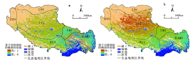
Fig.3 The spatial pattern of ecosystem vulnerability based on structural(a) and functional indices(b) in Tibetan Plateau图3 西藏高原基于结构(a)、功能指标(b)的生态系统脆弱性空间格局 |
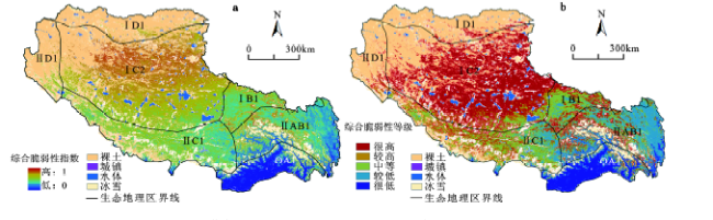
Fig.4 The spatial pattern of comprehensive ecosystem vulnerability(a) and its classes(b) in Tibetan Plateau图4 西藏高原生态系统综合脆弱性指数(a)与等级(b)空间格局 |
The authors have declared that no competing interests exist.
| [1] |
|
| [2] |
[
|
| [3] |
|
| [4] |
[
|
| [5] |
|
| [6] |
|
| [7] |
[
|
| [8] |
|
| [9] |
[
|
| [10] |
[
|
| [11] |
[
|
| [12] |
|
| [13] |
|
| [14] |
[
|
| [15] |
[
|
| [16] |
|
| [17] |
[
|
| [18] |
[
|
| [19] |
[
|
| [20] |
[
|
| [21] |
[
|
| [22] |
[
|
| [23] |
[
|
| [24] |
[
|
| [25] |
[
|
| [26] |
[
|
| [27] |
|
| [28] |
[
|
| [29] |
[
|
| [30] |
[
|
/
| 〈 |
|
〉 |
