
地理空间元数据关联网络的构建
作者简介:赵红伟(1987-),女,山东聊城人,博士研究生,主要研究方向为地理空间数据语义关联、地理空间数据共享。E-mail:zhaohw.10s@igsnrr.ac.cn
收稿日期: 2015-11-23
要求修回日期: 2016-05-04
网络出版日期: 2016-08-20
基金资助
国家自然科学基金项目(41371381)、科技部科技基础性工作专项项目(2013FY110900)、国家重大科学仪器设备开发专项(2012YQ06002704)、云南省科技计划项目(2012CA021)资助
Construction of Geospatial Metadata Association Network
Received date: 2015-11-23
Request revised date: 2016-05-04
Online published: 2016-08-20
Supported by
National Nature Science Foundation of China (41371381), Science and Technology Basic Work of Science and Technology (2013FY110900), the National Key Scientific Instrument and Equipment Development Project (2012YQ06002704), Science and Technology Project of Yunnan Province (2012CA021)
Copyright
赵红伟 , 诸云强 , 侯志伟 , 杨宏伟 . 地理空间元数据关联网络的构建[J]. 地理科学, 2016 , 36(8) : 1180 -1189 . DOI: 10.13249/j.cnki.sgs.2016.08.008
The rapid acquisition of geospatial data mainly depends on geospatial metadata. But the traditional organization of geospatial metadata and the keywords-based retrieval methods create barriers among metadata considering semantic relations between geospatial data such as spatial topology relationship, category relationship, resulting in a bottleneck in geospatial data sharing. In the context of big geospatial data, the development of linked data provides an effective practice for the semantic sharing and application of massive geospatial data. The linked geodata is intended to break the semantic barriers between geospatial data and form a data network with semantic realtions. Due to the complexity, diversity and uncertainy of geospatial data, linked geodata is often achieved through the association between metadata. Geospatial metadata contains a number of descriptive information. How to effectively organize vast amounts of geospatial metadata and map the metadata into the semantic space by simple way have become the hotspots in the field of geospatial data sharing. Construction of semantic associations among geospatial metadata is an effective means of performing semantic retrieval using related data technologies. Effective application of linked data depends on effective association models. Considering this, a method of constructing geospatial metadata association networks is proposed in this paper: firstly, a geospatial metadata association model is designed on basis of the resource description framework (RDF); secondly, a semantic relation between metadata is determined and the relationship is constructed; and finally, the degree of semantic relevance of the semantic relationship is calculated. In the association network, the metadata are nodes, the semantic relationships between the metadata are edges, and the degrees of semantic relevance are the weights of the edges. Every node is an RDF that has attribute properties, such as sources, spatial characteristics, temporal characteristics, and content, and has properties of semantic relationships. Experimental results showed that the constructed network could effectively support operations such as semantic association search and recommendation, and the retrieval results were more precise and accurate compared with traditional metadata retrieval methods based on keywords.
Key words: geospatial metadata; linked data; semantic relevance; association network
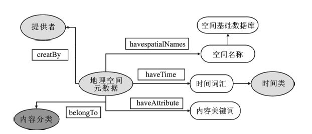
Fig.1 The descriptive model of geospatial metadata图1 地理空间元数据描述模型 |
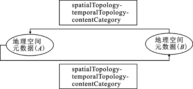
Fig.2 The relationship model of geospatial metadata图2 地理空间元数据关系模型 |
Table 1 Region connection calculus表1 RCC-8 拓扑关系 |
| 序号 | 关系代码 | 关系名称 | 语义解释 |
|---|---|---|---|
| 1 | DC | Disjoints | 相离(不相交) |
| 2 | EC | Meets | 相接 |
| 3 | EQ | Equals | 相等 |
| 4 | NTPP | Inside | 包含于,且两者边界不交 |
| 5 | NTPPi | Contains | 包含,且两者边界不交 |
| 6 | TPP | Coverby | 包含于,且两者边界相交 |
| 7 | TPPi | Covers | 包含,且两者边界相交 |
| 8 | PO | Overlaps | 部分重叠 |
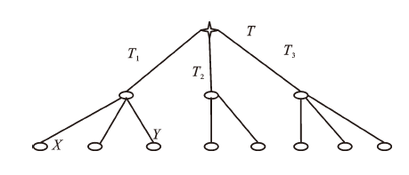
Fig.3 Classification tree of the contents图3 内容分类树 |
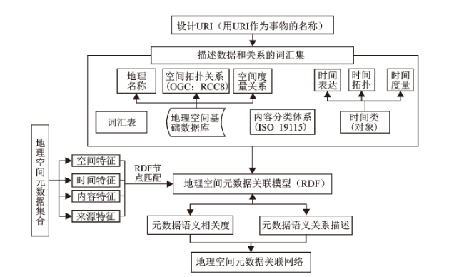
Fig.4 Flow chart of geographic spatial metadata association network construction图4 地理空间元数据关联网络构建的技术路线 |
Table 2 Weights scores for each relationship by experts表2 权重打分结果 |
| 权重项目 | 权重值 | 权重项目 | 权重值 |
|---|---|---|---|
| 内容关系(WF) | 41 | 关键词相同比例权重(WF1) | 58 |
| 内容分类(WF2) | 42 | ||
| 小计 | 100 | ||
| 空间关系(WS) | 35 | 空间重叠比例(WS21) | 60 |
| 距离相关度(WS22) | 40 | ||
| 小计 | 100 | ||
| 时间关系(WT) | 24 | 时间重叠比例(WT21) | 60 |
| 距离相关度(WT22) | 40 | ||
| 小计 | 100 | ||
| 合计 | 100 |
Table 3 The closely related metadata to “the climate research data of eastern margin of Tibetan Plateau (1956-1993)”表3 与“青藏高原东缘气象气候研究数据(1956~1993年)”关联较紧密的元数据 |
| 编号 | 元数据条目 | 语义关系 (A → B) | 语义关系释义 | 语义相 关度 |
|---|---|---|---|---|
| 1 | 青藏高原东缘气象气候研究数据(1956~1993年) | spatialEquals-temporalEquals-classBrotherOf | 空间:A与B相等;时间:A与B相等 内容:A 与B同类 | 1 |
| 2 | 青藏高原分区域气候数据(1984年) | spatialEquals-temporalContains-classBrotherOf | 空间:A与B相等;时间:A包含B 内容:A与B同类 | 0.9522 |
| 3 | 1951~2000年中国公里网格多年平均风速 | spatialInside-temporalDuring- classBrotherOf | 空间:A包含于B;时间:A包含于B 内容:A与B同类 | 0.9222 |
| 4 | 纳木错和慕士塔格大气化学成分数据集(2005~2009年) | spatialContains-temporalBefore-classBrotherOf | 空间:A包含B;时间:A在B之前 内容:A与B同类 | 0.6568 |
| 5 | 四川省紫色土区气象研究数据(1997~2003年) | spatialOverlaps-temporalBefore-classBrotherOf | 空间:A与B相交;时间:A在B之前 内容:A与B同类 | 0.6524 |
| 6 | 1971~2000年浙江省1∶25万累年平均降水量空间分布图 | spatialDisjionts-temporalOverlappedBy-classBrother | 空间:A与B相离;时间:A被B相交 内容:A与B同类 | 0.6037 |
| 7 | 1971~2000年浙江25万累年月平均极端最低和最高气温、月平均气温空间分布图 | spatialDisjionts-temporalOverlappedBy-classBrother | 空间:A与B相离;时间:A被B相交 内容:A与B同类 | 0.6037 |
| 8 | 青藏高原农田系统生态因子数据集(1960~2000年) | spatialEquals-temporalOverlappedBy-classNo | 空间:A与B相等;时间:A被B相交 内容:A与B不同类 | 0.5698 |
| 9 | 青藏高原草地分布面积、类型、经济特性数据集(1974~1976年) | spatialEquals-temporalContains-classNo | 空间:A与B相等;时间:A包含B 内容:A与B不同类 | 0.5625 |
| 10 | 青藏高原草地资源物种营养成分数据集(1974~1976年) | spatialEquals-temporalContains-classNo | 空间:A与B相等;时间:A包含B 内容:A与B不同类 | 0.5625 |
| 11 | 1981年青藏高原水分、水文研究数据 | spatialEquals-temporalContains-classNo | 空间:A与B相等;时间:A包含B 内容:A与B不同类 | 0.5507 |
| 12 | 1∶100万青藏高原水系流域图(1980~1982年) | spatialEquals-temporalContains-classNo | 空间:A与B相等;时间:A包含B 内容:A与B不同类 | 0.5507 |
| 13 | 青藏自然区划背景数据(1984年) | spatialEquals-temporalContains-classNo | 空间:A与B相等;时间:A包含B 内容:A与B不同类 | 0.5422 |
| 14 | 青藏高原湖泊水化学成分图(1990年) | spatialEquals-temporalContains-classNo | 空间:A与B相等;时间:A包含B 内容:A与B不同类 | 0.5298 |
| 15 | 青藏高原野生动物数据(1991年) | spatialEquals-temporalContains-classNo | 空间:A与B相等;时间:A包含B 内容:A与B不同类 | 0.5277 |
| 16 | 青藏高原森林资源系统生态因子数据集(1980~2000年) | spatialEquals-temporalOverlappedBy-classNo | 空间:A与B相交;时间:A被B相交 内容:A与B不同类 | 0.5170 |
| 17 | 1951~2000年中国公里网格风能数据 | spatialInside-temporalDuring- classNo | 空间:A包含于B;时间:A包含于B 内容:A与B不同类 | 0.5122 |
| 18 | 中国森林资源数据库(分省,分县,1950~1993年) | spatialInside-temporalDuring- classNo | 空间:A包含于B;时间:A包含于B 内容:A与B不同类 | 0.5098 |
| 19 | 中国地质灾害事件数据集(1949~2008) | spatialInside-temporalDuring- classNo | 空间:A包含于B;时间:A被B相交 内容:A与B不同类 | 0.5062 |
| 20 | 1961~2000年中国1∶100万生态环境背景数据(水、热要素) | spatialInside-temporalOverlappedBy-classNo | 空间:A包含于B;时间:A被B相交 内容:A与B不同类 | 0.4977 |
| 21 | 中国1∶400万耕地质量数据(1980 s) | spatialInside-temporalContains-classNo | 空间:A包含于B;时间:A包含B 内容:A与B不同类 | 0.4821 |
| 22 | 中国海岸带和海涂资源20世纪80年代综合调查数据 | spatialInside-temporalContains-classNo | 空间:A包含于B;时间:A包含B 内容:A与B不同类 | 0.4821 |
| 23 | 西藏部分河流的水文数据(1980~1989年) | spatialOverlaps-temporalContains-classNo | 空间:A与B相交;时间:A包含B 内容:A与B不同类 | 0.4821 |
| 24 | 中国农业物候(1980~1981年) | spatialInside-temporalContains-classNo | 空间:A包含于B;时间:A包含B 内容:A与B不同类 | 0.4806 |
| 25 | 中国草地资源数据库(分省,分县,1980 s) | spatialInside-temporalContains-classNo | 空间:A包含于B;时间:A包含B 内容:A与B不同类 | 0.4805 |
Table 4 The closely related metadata to “the 1∶10 million land use data of Jiangsu province (1980s)”表4 与“江苏省1∶10万土地利用数据(1980s)”关联较为紧密的元数据 |
| 编号 | 元数据条目 | 语义关系 (C → D) | 语义关系释义 | 语义 相关度 |
|---|---|---|---|---|
| 1 | 江苏省1∶10万土地利用数据(1980 s) | spatialEquals-temporalEquals- classBrotherOf | 空间:C与相等;时间:C 与 D 相等 内容:C 与 D 同类 | 1 |
| 2 | 中国土地资源数据库(1980~2001年,分省、分县) | spatialInside-temporalStarts- classBrotherOf | 空间:C 包含于D;时间:C 开始于D 内容:C 与 D 同类 | 0.8404 |
| 3 | 江苏省1∶10万土地利用数据(1995年) | spatialEquals-temporalBefore- classBrotherOf | 空间:C 与 D 相等;时间:C 在 D 之前 内容:C 与 D 同类 | 0.7646 |
| 4 | 江苏省1∶10万土地利用数据(2000年) | spatialEquals-temporalBefore- classBrotherOf | 空间:C 与 D 相等;时间:C 在 D 之前 内容:C 与 D 同类 | 0.7631 |
| 5 | 江苏省1∶10万土地利用数据(2005年) | spatialEquals-temporalBefore- classBrotherOf | 空间:C 与 D 相等;时间:C 在 D 之前 内容:C 与 D 同类 | 0.7623 |
| 6 | 江苏省1∶10万土地利用数据(2008年) | spatialEquals-temporalBefore- classBrotherOf | 空间:C 与 D 相等;时间:C 在 D 之前 内容:C 与 D 同类 | 0.7620 |
| 7 | 江苏省1∶10万土地利用数据(2010年) | spatialEquals-temporalBefore- classBrotherOf | 空间:C 与 D 相等;时间:C 在 D 之前 内容:C 与 D 同类 | 0.7619 |
| 8 | 上海市1∶10万土地利用数据(1980 s) | spatialMeets-temporalEquals- classBrotherOf | 空间:C 与 D 相接;时间:C 与 D 相等 内容:C 与 D 同类 | 0.7457 |
| 9 | 中国地区土地利用/土地覆盖数据集 | spatialOverlaps-temporalBefore- classBrotherOf | 空间:C 包含于D ;时间:C 在 D 之前 内容:C 与 D 同类 | 0.6268 |
| 10 | 安徽省1∶10万土地利用数据(2005年) | spatialMeets-temporalBefore- classBrotherOf | 空间:C 包含于D ;时间:C 在 D 之前 内容:C 与 D 不同类 | 0.5502 |
| 11 | 中国农业物候(1980~1981) | spatialInside-temporalStartedBy- classNo | 空间:C 包含于D ;时间:C 以 D 开始 内容:C 与 D 不同类 | 0.5382 |
| 12 | 上海市1∶10万土地利用数据(1995年) | spatialMeets-temporalBefore- classBrotherOf | 空间:C 与 D 相接;时间:C 在 D 之前 内容:C 与 D 同类 | 0.5103 |
| 13 | 上海市1∶10万土地利用数据(2000年) | spatialMeets-temporalBefore- classBrotherOf | 空间:C 与 D 相接;时间:C 在 D 之前 内容:C 与 D 同类 | 0.5088 |
| 14 | 上海市1∶10万土地利用数据(2005年) | spatialMeets-temporalBefore- classBrotherOf | 空间:C 与 D 相接;时间:C 在 D 之前 内容:C 与 D 同类 | 0.5080 |
| 15 | 上海市1∶10万土地利用数据(2008年) | spatialMeets-temporalBefore- classBrotherOf | 空间:C 与 D 相接;时间:C 在 D 之前 内容:C 与 D 同类 | 0.5077 |
| 16 | 1996年浙江省1∶25万数字化土地利用现状图 | spatialMeets-temporalBefore- classBrotherOf | 空间:C 与 D 相接;时间:C 在 D 之前 内容:C 与 D 同类 | 0.4963 |
| 17 | 中国1∶400万耕地质量数据(1980 s) | spatialInside-temporalEquals- classNo | 空间:C 包含于D ;时间:C 与 D 相等 内容:C 与 D 不同类 | 0.4537 |
| 18 | 中国海岸带和海涂资源20世纪80年代综合调查数据 | spatialInside-temporalEquals- classNo | 空间:C 包含于D ;时间:C 与 D 相等 内容:C 与 D 不同类 | 0.4537 |
| 19 | 中国历年县级的行政区划数据集(1980~2005) | spatialInside-temporalStarts- classNo | 空间:C 包含于D ;时间:C 开始于 D 内容:C 与 D 不同类 | 0.4269 |
| 20 | 1961~2000年中国1∶100万生态环境背景数据(水、热要素) | spatialInside-temporalDuring- classNo | 空间:C 包含于D ;时间:C 包含于D 内容:C 与 D 不同类 | 0.4257 |
| 21 | 中国地质灾害事件数据集(1949~2008) | spatialInside-temporalDuring- classNo | 空间:C 包含于D ;时间:C 包含于D 内容:C 与 D 不同类 | 0.4230 |
| 22 | 中国森林资源数据库(分省,分县,1950~1993年) | spatialInside-temporalDuring- classNo | 空间:C 包含于D ;时间:C 包含于D 内容:C 与 D 不同类 | 0.4204 |
| 23 | 1951~000年中国公里网格风能数据 | spatialInside-temporalDuring- classNo | 空间:C 包含于D ;时间:C 包含于D 内容:C 与 D 不同类 | 0.4188 |
| 24 | 1951~2000年中国公里网格多年平均风速 | spatialInside-temporalDuring- classNo | 空间:C 包含于D ;时间:C 包含于D 内容:C 与 D 不同类 | 0.4188 |
| 25 | 中国草地资源数据库(分省,分县,1980 s) | spatialInside-temporalStartedBy- classNo | 空间:C 包含于D ;时间:C 以 D 开始;内容:C 与 D 不同类 | 0.3894 |
The authors have declared that no competing interests exist.
| [1] |
|
| [2] |
|
| [3] |
[
|
| [4] |
|
| [5] |
|
| [6] |
|
| [7] |
|
| [8] |
|
| [9] |
|
| [10] |
|
| [11] |
|
| [12] |
|
| [13] |
[
|
| [14] |
|
| [15] |
|
| [16] |
|
| [17] |
|
/
| 〈 |
|
〉 |