
基于GIS的呼和浩特市近百年街道时空演变及其特征分析
|
乌敦(1979-),女(蒙古族),内蒙古鄂尔多斯人,副教授,硕导,主要从事历史城市地理研究。E-mail: aodun2002@163.com |
收稿日期: 2018-01-29
要求修回日期: 2018-04-15
网络出版日期: 2019-06-10
基金资助
国家自然科学基金项目(41761028)
内蒙古自然科学基金项目(2015MS0401)
内蒙古师范大学青年基金项目资助(2014ZRYB07)
版权
Spatial and Temporal Evolution and Characteristics of Hohhot Street During Recent 100 Years Based on GIS
Received date: 2018-01-29
Request revised date: 2018-04-15
Online published: 2019-06-10
Supported by
National Natural Science Foundation of China(41761028)
Inner Mongolia Natural Sciences Foundation(2015MS0401)
Inner Mongolia Normal University Youth Foundation(2014ZRYB07)
Copyright
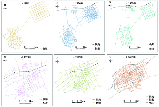
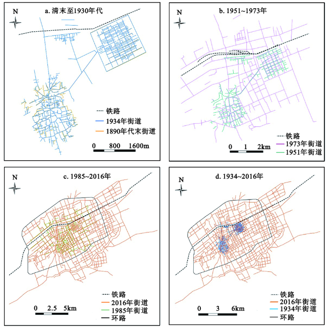
以历史文化名城——呼和浩特市城区为研究区,以GIS为技术平台,运用现代地图、古地图、遥感影像数据以及史料和现代文献,制作了6个典型时期历史街道GIS数据,定量与定性相结合分析了研究区近百余年的街道时空演变过程及其特征。结果显示:研究区近百年的街道时空演变具有“摊饼式”空间扩展特征、先集聚后分散的空间演变特征;解放初期至改革开放时期的街道演变具有向内填充式发展与向北缓慢扩展相结合演变的特点,而快速城市化时期研究区新增街道以原归化、绥远城为中心向四周延伸,呈现出向外扩展的空间演变特征;百余年后的今天,原归化城内的街巷基本消失,而绥远城内的街道基本上保持了清代的棋盘式格局;人口增加、城市规划与建设、集聚与分散以及地质地貌条件等是研究区街道时空演变的主要驱动因素。
乌敦 , 阿拉腾图娅 , 木希叶乐 . 基于GIS的呼和浩特市近百年街道时空演变及其特征分析[J]. 地理科学, 2019 , 39(6) : 987 -996 . DOI: 10.13249/j.cnki.sgs.2019.06.014
Hohhot is one of the famous historical and cultural cities in China. It is not only the forward position in the construction of the “China-Mongolia-Russia Economic Corridor”, but also one of the important supporting points for the economic development in the northern border of China. The article uses GIS as the technology platform, taking Hohhot as the research area, and adopts modern cartography, ancient maps, remote sensing image data, historical recordsand modern literature to producea GIS data of the streets during 6 typical historical periods. The combination of quantitative and qualitative methods are used to analyze the spatial-temporal evolution process of the streets for nearly 100 years as well as its characteristics. The results show that in the nearly 100 years from the end of the Qing Dynasty to the beginning of the 21st century, the streets of the study areashad gradually formed the 3-dimensional network system combining expressways, ring roads, main roads, avenue, side streets, and lanes from an disorderly street system combined with a checkerboard type. nowadays. The spatial-temporal evolution of streets in the study areaspossesses the characteristics of “spreading pie like” spacial expansion, and of spatial evolution which gather first and then disperse.The study areas expended from 9 km 2 in the late Qing Dynasty to 256.48 km 2 in 2016, about 28.49 times extended. Compared with the periods of late Qing and early Ming Dynasties, the streets in 2016 extended and expanded from the scope of the original Guihua City and Suiyuan City to the surrounding areas. From the early years after liberation to the reform and opening-up period, the evolution of streets was characterized by the combination of inward-filling development and slow northward expansion. During the period of rapid urbanization, the newly-added streets in the study areas extended aroundthese 2 cities in question, showing the features of spatial evolutionof outward expansion. Today, more than 100 years later, the streets and lanes in the original Guihua city have basically disappeared, while the streets in Suiyuan City have basically maintained the chessboard pattern of the Qing Dynasty. The main driving factors for the spatial-temporal evolution of the streets in the study areas include population growth, urban planning and construction, agglomeration and dispersion, as well as geological features.
Key words: historical streets; ancient maps; GIS; urban historical geography; Hohhot
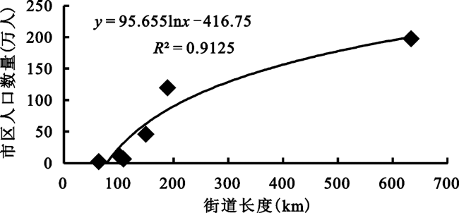
表1 呼和浩特市区近百年的街道长度与密度变化Table 1 The changing of street density in Hohhot during recent century |
| 清末 | 1934年 | 1951年 | 1973年 | 1985年 | 2016年 | |
|---|---|---|---|---|---|---|
| 街道长度(km) | 63.92 | 107.54 | 103 | 149.64 | 189.45 | 633.2 |
| 街道密度(km/km2) | 0.45 | 0.76 | 0.73 | 1.06 | 1.34 | 4.48 |
| [1] |
侯仁之 . 城市历史地理的研究与城市规划[J]. 地理学报, 1979,34(4):315-328.
[
|
| [2] |
林珲, 赖进贵, 周成虎 . 空间综合人文学与社会科学研究[M]. 北京: 科学出版社, 2010.
[
|
| [3] |
葛剑雄 . 中国历史地图——从传统到数字化[J].历史地理, 2002(18):1-11.
[
|
| [4] |
唐晓峰 . 北京历史地图的数字化[J]. 北京社会科学, 2004(4):90-94.
[
|
| [5] |
王均 . 陕西省资源环境本底数据库建设及GIS在历史地理研究中的应用设想[J]. 中国历史地理论丛, 2002,17(3):129-137.
[
|
| [6] |
吴静, 王铮 . 中国2000年以来人口地理演变的Agent模拟分析[M]//林珲,等.空间综合人文学与社会科学研究. 北京: 科学出版社, 2010: 94-103.
[
|
| [7] |
胡明星, 董卫 . GIS技术在历史街区保护规划中的应用研究[J].建筑学报, 2004(12):63-65.
[
|
| [8] |
周丙锋, 周文业, 赵文吉 . 中国历史地理数字化应用平台研究[J]. 测绘科学, 2008,33(4):199-202.
[
|
| [9] |
陈刚 . 数字人文与历史地理信息化研究[J].南京社会科学, 2014(3):136-142.
[
|
| [10] |
董明, 陈品祥 . 基于GIS技术的北京旧城胡同现状与历史变迁研究[J].测绘通报, 2007(5):34-37.
[
|
| [11] |
王一帆, 孔云峰, 马海涛 . 运用GIS 进行古代城市结构复原的尝试:以北宋东京城为例[J]. 地球信息科学, 2007,29(5):43-49.
[
|
| [12] |
李建, 董卫 . 古代城市地图转译的历史空间整合方法——以杭州市古代城市地图为例[J].城市规划学刊, 2008(2):93-98.
[
|
| [13] |
夏鹏, 龙元 . “图叠”历史空间——获取旧城历史空间演变信息方法探讨[J].建筑学报, 2010(2):26-30.
[
|
| [14] |
吴俊范 . 1900~1949 年间上海水乡景观蜕变的复原与分析[J]. 中国历史地理论丛, 2010(1):26-39.
[
|
| [15] |
牟振宇 . 近代上海城市边缘区土地利用方式转变过程研究——基于GIS的近代上海法租界个案研究(1898-1914)[J]. 复旦学报(社会科学版), 2010(4):106-113.
[
|
| [16] |
周岚, 叶斌, 王芙蓉 , 等. 基于GIS的城市历史空间格局数字复原研究——以南京市为例[J]. 规划师, 2011,27(4):63-68.
[
|
| [17] |
汪芳, 严琳, 熊忻恺 , 等. 基于游客认知的历史地段城市记忆研究——以北京南锣鼓巷历史地段为例[J]. 地理学报, 2012,67(4):545-556.
[
|
| [18] |
何韶颖, 汤众 . 基于GIS的历史城市形态研究——以清代广州寺院分布影响因素分析为例[J]. 西安建筑科技大学学报(自然科学版), 2012,44(5):672-684.
[
|
| [19] |
李秋璞, 陈金华, 高伟雯 . 基于GIS的历史文化名城地名演变研究——以泉州城为例[J]. 乐山师范学院学报, 2016,31(4):55-60.
[
|
| [20] |
任云英, 周在辉 . 基于GIS的河西走廊段历史城市文脉要素方法研究[J]. 建筑与文化, 2016(7):52-54.
[
|
| [21] |
|
| [22] |
尔德尼其其格, 阿拉腾图娅, 乌敦 . 基于GIS的呼和浩特市区近百年城市形态演化特征研究[J]. 内蒙古师范大学学报(自然科学汉文版), 2012,41(6):675-680.
[
|
| [23] |
尔德尼其其格, 阿拉腾图娅, 乌敦 . 基于GIS和RS的呼和浩特市近百年城市空间扩展及其演变趋势[J]. 干旱区资源与环境, 2013,29(1):33-39.
[
|
| [24] |
吴永娟, 王丽敏 . 基于GIS 的呼和浩特市区街道信息变迁分析[J]. 测绘与空间地理信息, 2016,39(4):70-72.
[
|
| [25] |
金启孮 . 呼和浩特旧城的变迁和新城的兴建(呼和浩特史话之一章)[J]. 内蒙古大学学报, 1960(2):20-22.
[
|
| [26] |
近藤富城 . 清代归化绥远城市区的形成过程[J].蒙古学信息, 1996(1):23-28.
[
|
| [27] |
乌云格日勒 . 十八至二十世纪初内蒙古城镇研究[M]. 呼和浩特: 内蒙古人民出版社, 2005: 52-58.
[
|
| [28] |
张威 . 1572~1921年呼和浩特城市形态演变分析[J]. 内蒙古社会科学, 2009,30(2):55-60.
[
|
| [29] |
张威 . 民国三年:呼和浩特城市形态演变的历史转折点[J]. 内蒙古社会科学(汉文版), 2013,34(5):57-60.
[
|
| [30] |
牛淑贞 . 归绥城市地理研究(1572-1937)[M] . 哈尔滨: 黑龙江人民出版社, 2014.
[
|
| [31] |
黄丽生 . 由军事征掠到城市贸易:内蒙古归绥地区的社会经济变迁(14世纪中至20世纪初)[M]. 中国台北:“国立”台湾师范大学历史研究所, 1995(民国八十四年):1-321.
[
|
| [32] |
包慕萍 . モンゴルにおける都市建筑史研究——遊牧と定住の重層都市フフホト[M]. 東京:株式会社東方書店, 2005.
[
|
| [33] |
珠荣嘎 . 阿勒坦汗传[M]. 呼和浩特: 内蒙古人民出版社, 1990: 239.
[
|
| [34] |
贻谷, 高赓恩 . 土默特志(影印本) [M]. 中国台北: 台湾成文出版社, 1968.
[
|
| [35] |
今堀诚二 . 中国封建社会の构造-归绥(呼和浩特)における社会集团の实态调查[M]. 日本学术振兴会刊, 1955.
[
|
| [36] |
森川哲雄 . 17世纪前半叶的归化城[J].蒙古学资料与情报, 1985(3、4):15-18.
[
|
| [37] |
贻谷, 高赓恩 . 归绥道志(内蒙古图书馆影印本)[M]. 呼和浩特: 远方出版社, 2007.
[
|
| [38] |
戴学稷 . 呼和浩特简史[M]. 北京:中华书局, 1981: 47.
[
|
| [39] |
绥远通志馆 . 绥远通志稿(重排本) [M]. 呼和浩特: 内蒙古人民出版社, 2007.
[
|
| [40] |
佟靖仁 . 绥远城驻防志(满汉合璧四卷本) [M]. 呼和浩特: 内蒙古大学出版社, 1991: 161-163.
[
|
| [41] |
高赓恩 . 绥远旗志(光绪三十三年刊本)[M]. 中国台北:台湾华文书局, 1969.
[
|
| [42] |
王轩 . (光绪)山西通志(中华书局点校本)[M]. 北京:中华书局, 1990.
[
|
| [43] |
金海, 齐木德道尔吉, 胡日查 , 等. 清代蒙古志[M]. 呼和浩特: 内蒙古人民出版社, 2010: 282.
[
|
| [44] |
戴学稷 . 呼和浩特简史[M].北京:中华书局, 1981:
[
|
| [45] |
刘鸿逹, 沈潜修 . 归化城厅志(上册)[M]. 呼和浩特: 远方出版社, 2011: 1-2.
[
|
| [46] |
光华舆地学社(编制). 中华人民共和国新地图[M]. 上海:生活•读书•新知三联书店, 1951: 21-22.
[ Guanghua Yudi Institute. New map of the People's Republic of China. Shanghai: Life•Reading•Xinzhi Sanlian Bookstore, 1951: 21-22]
|
| [47] |
内蒙古自治区革命委员会测绘局. 中华人民共和国内蒙古自治区地图集[M]. 呼和浩特:内蒙古自治区革命委员会测绘局, 1973: 40.
[ Inner Mongolia Autonomous Region Revolutionary Committee Surveying and Mapping Bureau. Atlas of Inner Mongolia Autonomous Region of the People's Republic of China. Hohhot: Inner Mongolia Autonomous Region Revolutionary Committee Surveying and Mapping Bureau, 1973: 40.]
|
| [48] |
呼和浩特市地名志编辑委员会. 呼和浩特市地名志[M]. 呼和浩特: 内蒙古自治区地名委员会办公室出版, 1985.
[ Hohhot's Geographical Names Editing Committee. Hohhot's geographical names. Hohhot: Inner Mongolia Geographic Names Committee Office Publishing, 1985.]
|
| [49] |
内蒙古自治区地图院. 呼和浩特市街区图[M]. 呼和浩特:内蒙古自治区地图院, 2016.
[ Map Insititue of Inner Mongolia Autonomous Region. Map of Hohhot city block. Hohhot: Map Insititue of Inner Mongolia Autonomous Region, 2016.]
|
| [50] |
阿·马·波兹德涅耶夫 . 蒙古及蒙古人(第二卷) [M].刘汉明,等译. 呼和浩特: 内蒙古人民出版社, 1983: 91-93.
[
|
| [51] |
川村得三 . 蒙疆經濟地理[M]. 東京:東京叢文阁, 1941: 167.
[
|
| [52] |
辞海编辑委员会. 辞海[M]. 上海: 上海辞书出版社, 1999: 1080.
[ Cihai Editorial Board. Cihai. Shanghai: Shanghai Dictionary Press, 1999: 1080.]
|
| [53] |
中华人民共和国建设部. GB 50220-1995城市道路交通规划设计规范[M]. 北京: 中国计划出版社, 2005: 70-84.
[ Ministry of Construction in the People's Republic of China. GB50220-1995 Urban road traffic planning and design specifications. Beijing: China Planning Press, 2005: 70-84.]
|
| [54] |
布仁, 范海娇 . 呼和浩特市城市发展及规划编制简史[J].内蒙古师范大学学报(哲学社会科学版), 2013(4):121-126.
[
|
/
| 〈 |
|
〉 |