
基于面积−高程积分的他念他翁山玉曲流域地貌学分析
|
张威(1969−),男,吉林松原人,教授,博导,主要研究方向为环境与灾害地貌。E-mail: zhangweilnu@163.com |
收稿日期: 2019-11-29
网络出版日期: 2020-12-07
基金资助
国家自然科学基金项目(41671005)资助
版权
Geomorphologic Analysis of the Yuqu River Drainage basin in Tenasserim Chain Based on Hypsometric Integral Value
Received date: 2019-11-29
Online published: 2020-12-07
Supported by
National Natural Science Foundation of China (41671005)
Copyright
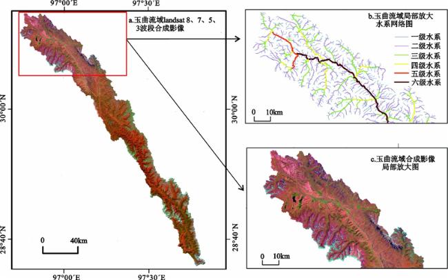
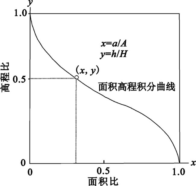
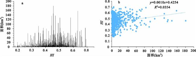
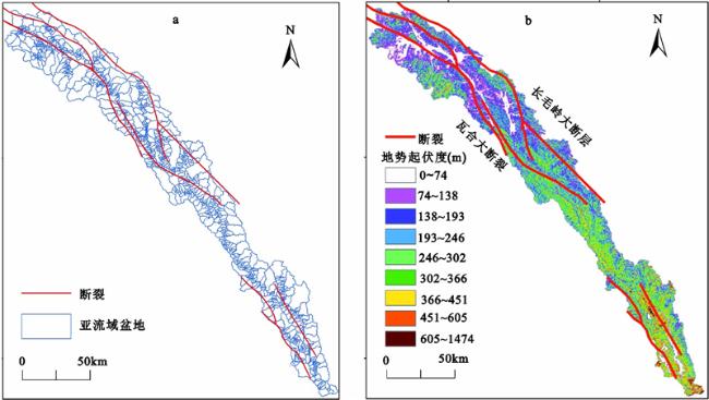
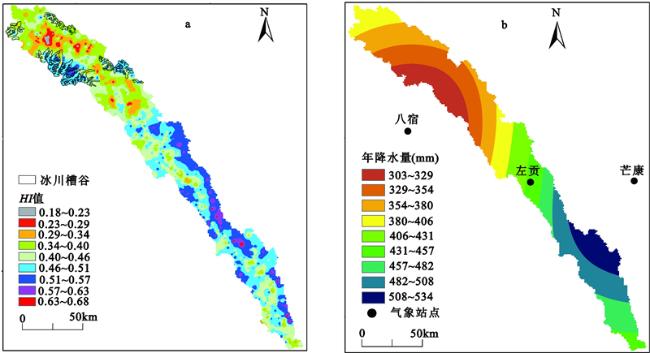
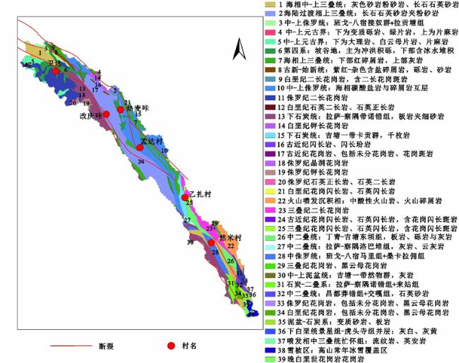
以他念他翁山玉曲流域为研究区,利用ArcGIS中的水文分析工具,将玉曲流域划分为1 030个亚流域盆地,采用高程起伏比法,对亚流域盆地进行面积−高程积分值(HI)计算。结合研究区的构造运动、岩性、地形起伏度、冰川作用等,探讨HI值的分布特征及主要影响因素,并确定研究区的地貌演化阶段。研究结果显示:① 玉曲流域所有亚流域盆地的HI值介于0.18~0.70,HI平均值为0.44,整体处于侵蚀循环的壮年和老年阶段。② 长毛岭大断层和瓦合大断裂经过玉曲流域,2条断裂的HI平均值分别为0.47和0.42,长毛岭大断层的活动性要高于瓦合大断裂,说明构造因素对HI值存在一定影响。③ 由于不同亚流域盆地内岩性抗侵蚀能力不同,导致HI值存在着较大差异,花岗岩、闪长岩等侵入岩(平均值0.55)>砾岩、灰岩等沉积岩(平均值0.49)>海相碳酸盐岩(平均值0.47)>夹杂着粉砂岩、页岩和泥岩的长石石英砂岩(平均值0.42)>第四系冲积物和冰碛物(平均值0.35)。④ 对于玉曲流域而言降水量对HI值的影响较小。
张威 , 唐倩玉 , 刘亮 , 沈俊杰 , 李亚鹏 , 成然 . 基于面积−高程积分的他念他翁山玉曲流域地貌学分析[J]. 地理科学, 2020 , 40(8) : 1394 -1402 . DOI: 10.13249/j.cnki.sgs.2020.08.019
The area elevation analysis of the basin is usually used to reveal the stage of geomorphological development, which is of great scientific significance for exploring the evolution of the basin environment. In this paper, the Yuqu River Basin of middle Tenasserim Chain is used as the research area. Using the hydrological analysis tools in Arcgis, the Yuqu River Basin is divided into 1 030 sub-basin basins. The area-elevation integral value (HI) of sub-basin basin is calculated using the elevation fluctuation ratio method. Combined with the tectonic movement, lithology, topographic relief and glacial action in the study area, the distribution characteristics and main influencing factors of HI values are discussed, and the geomorphological evolution stage of the study area is determined. The results display that: 1) The HI value of all sub-basin basins in the Yuqu River Basin is between 0.18 and 0.70, and the average HI is 0.44. The whole is in the strong and old stage of the erosion cycle. 2) The two major faults of the Changmaoling large fault and the Wahe large fault pass through the Yuqu basin, and the average HI values of the two faults are 0.47 and 0.42, respectively. The activity of the Changmaoling fault is higher than that of the Wahe fault, indicating that the construction factor has a certain influence on the HI value. 3) Due to the different lithologic erosion resistance in different sub-basin basins, the HI values are quite different. Intrusive rocks such as granite and diorite (average 0.55)> Conglomerate, limestone and other sedimentary rocks (average 0.49)> Marine carbonate rocks (average 0.47)> Mixed with siltstone, shale, Feldspar quartz sandstone of mudstone (average 0.42)> Quaternary alluvial and glacial till (average 0.35). 4) For the Yuqu River brainage, precipitation has little influence on HI value.
Key words: Yuqu River drainage basin; hypsometric integral value; tectonic; lithology; glacier
表 1 玉曲流域网格单元与平均地势起伏度对应关系Table 1 Relation between grid units and average relief amplitude in the Yuqu River drainage basin |
| 网格大小 | 面积(104m2) | 平均地势起伏度(m) | 网格大小 | 面积(104m2) | 平均地势起伏度(m) | 网格大小 | 面积(104m2) | 平均地势起伏度(m) | ||
| 2×2 | 3.24 | 17.49 | 18×18 | 262.44 | 229.01 | 34×34 | 936.36 | 372.23 | ||
| 3×3 | 7.29 | 34.00 | 19×19 | 292.41 | 239.66 | 35×35 | 992.25 | 379.61 | ||
| 4×4 | 12.96 | 49.86 | 20×20 | 324.00 | 249.70 | 36×36 | 1049.76 | 386.67 | ||
| 5×5 | 20.25 | 65.20 | 21×21 | 357.21 | 259.31 | 37×37 | 1108.89 | 394.90 | ||
| 6×6 | 29.16 | 79.99 | 22×22 | 392.04 | 269.61 | 38×38 | 1169.64 | 401.38 | ||
| 7×7 | 39.69 | 94.35 | 23×23 | 428.49 | 279.20 | 39×39 | 1232.01 | 408.68 | ||
| 8×8 | 51.84 | 108.31 | 24×24 | 466.56 | 288.55 | 40×40 | 1296.00 | 415.37 | ||
| 9×9 | 65.61 | 121.88 | 25×25 | 506.25 | 297.44 | 41×41 | 1361.61 | 421.85 | ||
| 10×10 | 81.00 | 135.13 | 26×26 | 547.56 | 306.50 | 42×42 | 1428.84 | 429.49 | ||
| 11×11 | 98.01 | 147.96 | 27×27 | 590.49 | 314.69 | 43×43 | 1497.69 | 435.81 | ||
| 12×12 | 116.64 | 160.43 | 28×28 | 635.04 | 323.89 | 44×44 | 1568.16 | 441.07 | ||
| 13×13 | 136.89 | 172.70 | 29×29 | 681.21 | 332.83 | 45×45 | 1640.25 | 447.06 | ||
| 14×14 | 158.76 | 184.54 | 30×30 | 729.00 | 340.58 | 46×46 | 1713.96 | 454.47 | ||
| 15×15 | 182.25 | 196.04 | 31×31 | 778.41 | 348.61 | 47×47 | 1789.29 | 461.33 | ||
| 16×16 | 207.36 | 207.02 | 32×32 | 829.44 | 355.42 | 48×48 | 1866.24 | 465.59 | ||
| 17×17 | 234.09 | 218.18 | 33×33 | 882.09 | 364.53 | 49×49 | 1944.81 | 473.06 |
| [1] |
Strahler A H Hypsometric (area-altitude) analysis of erosional topography[J]. Bulletin of the Geological Society of America, 1952. 63 (11): 1117- 1142.
|
| [2] |
刘蓓蓓, 崔之久, 刘耕年, 等 基于面积−高程积分法的岷山雪宝顶−九寨沟地貌形态分析[J]. 第四纪研究, 2017. 37 (2): 224- 233.
Liu Beibei, Cui Zhijiu, Liu Gengnian et al Geomorphologic analysis of the Xuebaoding-Jiuzhaigou area in Min Shan based on hypsometric integral method[J]. Quaternary Sciences, 2017. 37 (2): 224- 233.
|
| [3] |
常直杨, 王建, 白世彪, 等 面积高程积分值计算方法的比较[J]. 干旱区资源与环境, 2015. 29 (3): 171- 175.
Chang Zhiyang, Wang Jian, Bai Shibiao et al Comparison of hypsometric integral methods[J]. Journal of Arid Land Resources and Environment, 2015. 29 (3): 171- 175.
|
| [4] |
祝士杰, 汤国安, 李发源, 等 基于DEM的黄土高原面积高程积分研究[J]. 地理学报, 2013. 68 (7): 921- 932.
Zhu Shijie, Tang Guoan, Li fayuan et al Spatial variation of hypsometric integral in the Loess Plateau based on DEM[J]. Acta Geographica Sinica, 2013. 68 (7): 921- 932.
|
| [5] |
赵洪壮, 李有利, 杨景春, 等 天山北麓流域面积高度积分特征及其构造意义[J]. 山地学报, 2009. 27 (3): 31- 38.
Zhao Hongzhuang, Li Youli, Yang Jingchun et al Geomorphology characcteristic and tectonic response of the northern Tianshan represented by hypsometric integral[J]. Journal of Mountain Science, 2009. 27 (3): 31- 38.
|
| [6] |
邵崇建, 李勇, 赵国华, 等 基于面积−高程积分对龙门山南段山前河流的构造地貌研究[J]. 现代地质, 2015. 29 (4): 727- 737.
Shao Chongjian, Li Yong, Zhao Guohua et al Tectonic geomorphology analysis of piedmont rivers in the southern section of Longmenshan based on hypsometric integral[J]. Geoscience, 2015. 29 (4): 727- 737.
|
| [7] |
张天琪, 王振, 张晓明, 等 北天山乌鲁木齐河流域面积−高程积分及其地貌意义[J]. 第四纪研究, 2015. 35 (1): 60- 70.
Zhang Tianqi, Wang Zhen, Zhang Xiaoming et al Hypsometric integral analysis of the Urumchi River drainage basin and its implications for topographic evolution[J]. Quaternary Sciences, 2015. 35 (1): 60- 70.
|
| [8] |
常直杨, 王建, 白世彪, 等 空间自相关分析在面积高程积分中的应用[J]. 山地学报, 2014. 32 (1): 1- 10.
Chang Zhiyang, Wang Jian, Bai Shibiao et al The technique of spatial autocorrelation for the hypsometric integral[J]. Journal of Mountain Science, 2014. 32 (1): 1- 10.
|
| [9] |
中国科学院青藏高原综合科学考察队. 西藏河流与湖泊[M]. 北京: 科学出版社, 1984.
Qinghai-Tibet Plateau Comprehensive Scientific Expedition Team of the Chinese Academy of Sciences.Rivers and lakes in Tibet. Beijing: Science Press, 1984.
|
| [10] |
中国科学院青藏高原综合科学考察队. 西藏地貌[M]. 北京: 科学出版社, 1983.
Qinghai-Tibet Plateau Comprehensive Scientific Expedition Team of the Chinese Academy of Sciences. Geomorphology of Xizang. Beijing: Science Press, 1983.
|
| [11] |
白重瑷, 施雅风. 中国冰川概论[M]. 北京: 科学出版社, 1988.
Bai Chongyuan, Shi Yafeng.An introduction to glaciers in China. Beijing: Science Press, 1988.
|
| [12] |
殷媛. 应用ELA和气象要素反演他念他翁山中段古气候环境[D]. 大连: 辽宁师范大学, 2017.
Yin Yuan. Inversing the Middle Tenasserim Chain’s ancient climate environment by ELA and meteorological elements. Dalian: Liaoning Normal University, 2017.
|
| [13] |
李吉均. 横断山冰川[M]. 北京: 科学出版社, 1996.
Li Jijun. Glacier in the Hengduan Mountains[M]. Beijing: Science Press, 1996.
|
| [14] |
柴乐. 他念他翁山第四纪冰川地貌过程及其对西南季风的响应[D]. 大连: 辽宁师范大学, 2019.
Chai Le. Glacial geomorphologic process and its response to the Southwest Monsoon in the Taniantaweng Shan during the Quaternary. Dalian: Liaoning Normal University, 2019.
|
| [15] |
张威, 柴乐 他念他翁山中段第四纪冰川作用ESR定年初步研究[J]. 冰川冻土, 2016. 38 (5): 1281- 1291.
Zhang Wei, Chai Le The preliminary study of the Quaternary glacier in the middle part of the Tenasserim Chain with ESR dating method[J]. Journal of Glaciology and Geocryology, 2016. 38 (5): 1281- 1291.
|
| [16] |
张威, 唐倩玉 他念他翁山中段第四纪冰川沉积物时空分布特征与环境[J]. 地理科学进展, 2019. 38 (6): 904- 917.
Zhang Wei, Tang Qianyu Spatiotemporal characteristics and the environment of Quaternary glacier deposits in middle Tenasserim Chain[J]. Progress in Geography, 2019. 38 (6): 904- 917.
|
| [17] |
Zhang W, Chai L, Ian S E et al Geomorphic features of Quaternary glaciation in the Taniantaweng Mountain, on the southeastern Qinghai-Tibet Plateau[J]. Journal of Mountain Science, 2019. 16 (2): 256- 274.
|
| [18] |
陈福忠, 廖国兴 昌都地区地质基本特征[J]. 青藏高原地质文集, 1983. (4): 213- 228.
Chen Fuzhong, Liao Guoxing The basic geological characteristics in Qamdo district[J]. Contribution to the Geology of the Qinghai-Xizang(Tibet) Plateau, 1983. (4): 213- 228.
|
| [19] |
秦翔, 施炜, 李恒强, 等 基于DEM地形特征因子的青藏高原东北缘宁南弧形断裂带活动性分析[J]. 第四纪研究, 2017. 37 (2): 213- 223.
Qin Xiang, Shi Wei, Li Hengqiang et al Tectonic differences of the southern Ningxia arc-shape faults in the northeast Tibetan Plateau based on digital elevation model[J]. Quaternary Sciences, 2017. 37 (2): 213- 223.
|
| [20] |
Tarboton D G, Bras R L, Rodriguez-Iturbe I On the extraction of channel networks from digital elevation data[J]. Hydrological Processes, 1991. 5 (1): 81- 100.
|
| [21] |
刘高, 杨瑞娟, 苏晓亮, 等 平凉崆峒区黄土沟谷系统形态特征[J]. 兰州大学学报(自然科学版), 2018. 54 (3): 317- 322.
Liu Gao, Yang Ruijuan, Su Xiaoliang et al Morphological characteristics of the loess gully system in the Kongtong area of Pingliang city[J]. Journal of Lanzhou University:Natural Sciences, 2018. 54 (3): 317- 322.
|
| [22] |
张敬春, 李川川, 张梅, 等 格尔木河流域面积−高程积分值的地貌学分析[J]. 山地学报, 2011. 29 (3): 257- 268.
Zhang Jingchun, Li Chuanchuan, Zhang Mei et al Geomorphologic analysis of the Golmud river drainage basin based on hypsometric integral value[J]. Journal of Mountain Science, 2011. 29 (3): 257- 268.
|
| [23] |
施炜 黄河中游晋陕峡谷的DEM流域特征分析及其新构造意义[J]. 第四纪研究, 2008. 28 (2): 288- 298.
Shi Wei DEM drainage analysis of the Shanxi-Shaanxi gorge in the middle reaches of the Huanghe River and its neotectonic implications[J]. Quaternary Sciences, 2008. 28 (2): 288- 298.
|
| [24] |
Gajbhiye S, Mishra S K, Pandey A Hypsometric analysis of Shakkar river catchment through geographical information system[J]. Journal of the Geological Society of India, 2014. 84 (2): 192- 196.
|
| [25] |
Ali K A A Hypsometric analysis of Jabal Sanam-Southern Iraq using GIS[J]. Journal of Basrah Researches(Sciences), 2015. 41 (2): 15- 25.
|
| [26] |
Pike R J, Wilson S E Elevation-relief ratio, hypsometric integral, and geomorphic area-altitude analysis[J]. Geological Society of America Bulletin, 1971. 82 (4): 1079- 1084.
|
| [27] |
张文杰, 张燕飞, 谭红兵 基于DEM的西藏线性构造研究[J]. 干旱区资源与环境, 2015. 29 (7): 187- 191.
Zhang Wenjie, Zhang Yanfei, Tan Hongbing An analysis of Tibetan lineaments using shaded relief images derived from digital elevation model (DEM)[J]. Journal of Arid Land Resources and Environment, 2015. 29 (7): 187- 191.
|
| [28] |
毛玉平, 韩新民. 云南地区强震(M≥6级)研究[M]. 昆明: 云南科技出版社, 2003.
Mao Yuping, Han Xinmin.Study on strong earthquake (M≥6) in Yunnan. Kunming: Yunnan Science and Technology Press, 2003.
|
| [29] |
文升梁, 张彦琪, 尼玛, 等 西藏左贡、芒康交界6.1级地震烈度与发震构造分析[J]. 震灾防御技术, 2014. 9 (4): 950- 959.
Wen Shengliang, Zhang Yanqi, Ni Ma et al Intensity and seismo-tectonics of the Zuogong-Mangkang Ms6.1[J]. Earthquake, 2014. 9 (4): 950- 959.
|
| [30] |
魏亚刚. 澜沧江中上游河流阶地序列及其与构造抬升的关系[D]. 大连: 辽宁师范大学, 2016.
Wei Yagang. River terrace sequences in upstream of Lancang River and its relevance with structural uplifting. Dalian: Liaoning Normal University, 2016.
|
| [31] |
李光涛, 陈国星, 苏刚, 等 滇西地区怒江河流阶地、夷平面变形反映的第四纪构造运动[J]. 地震, 2008. 28 (7): 125- 132.
Li Guangtao, Chen Guoxing, Su Gang et al Significant Quaternary tectonic movement reflected by deformation of river terrace and planation surface in Western Yunnan Region[J]. Earthquake, 2008. 28 (7): 125- 132.
|
| [32] |
韩海辉, 高婷, 易欢, 等 基于变点分析法提取地势起伏度−以青藏高原为例[J]. 地理科学, 2012. 32 (1): 101- 104.
Han Haihui, Gao Ting, Yi Huan et al Extraction of relief amplitude based on change point method: A case study on the Tibetan Plateau[J]. Scientia Geographica Sinica, 2012. 32 (1): 101- 104.
|
| [33] |
苏琦. 青藏高原东北缘典型流域地貌参数分析与构造变形探讨[D]. 兰州: 中国地震局兰州地震研究所, 2015.
Su Qi. Study on typical drainage basins along Northeastern Tibetan Plateau and its tectonic deformation. Lanzhou: Lanzhou Institute of Seismology, China Earthquake Administration, 2015.
|
/
| 〈 |
|
〉 |