
江苏省耕地细碎化评价与土地整治分区研究
|
刘晶(1992-),女,山东济南人,博士研究生,主要从事土地整治与国土空间优化利用研究。E-mail:liujingxwy@163.com |
收稿日期: 2018-05-08
要求修回日期: 2018-08-11
网络出版日期: 2021-03-17
基金资助
国家科技支撑计划项目(2015BAD06B02)
南京大学博士研究生创新创意研究计划项目资助(CXCY18-21)
版权
Evaluation of Cultivated Land Fragmentation and Guidance of Land Consolidation at Provincial Level
Received date: 2018-05-08
Request revised date: 2018-08-11
Online published: 2021-03-17
Supported by
The National Science Technology Support Plan Projects of China(2015BAD06B02)
Nanjing University Innovation and Creative Program for PhD Candidate(CXCY18-21)
Copyright
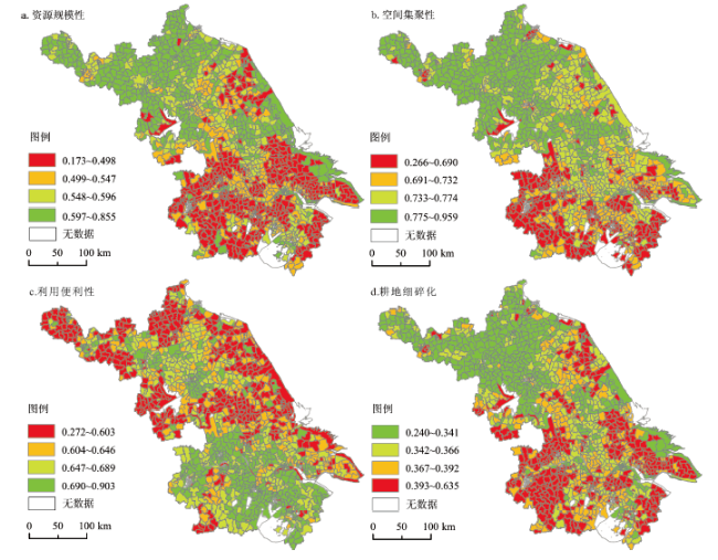
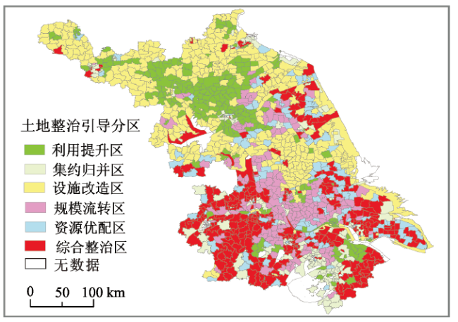
在明确耕地细碎化内涵空间尺度特征的基础上,从资源规模性、空间集聚性和生产便利性3方面构建耕地细碎化空间测度体系,以江苏省为例,综合运用地理空间分析、数理统计分析等方法,开展了省域尺度耕地细碎化多维评价及相应的土地整治协同探讨。研究表明:① 江苏省资源规模属性值总体偏低,呈现苏北-苏中-苏南逐级递减的分异格局;空间集聚属性值总体较高,但区域差异明显,高值区主要集中在徐淮平原及里下河平原地区;利用便利属性值总体呈现与资源规模及集聚状况相反的格局特征,苏南明显高于苏中和苏北地区,两极分化明显,地域差异较大;② 在乡镇尺度对各分维属性进行耦合形成江苏省耕地细碎化指数,省域尺度下该指数呈现从北到南逐渐增加的格局特征,表现为北部的低值聚集区和西南部的高值聚集区;③ 基于区域耕地细碎化不同属性特征的层次组合特点,全省可划分为利用提升区、集约归并区、设施改造区、规模流转区、资源优配区和综合整治区6种类型分区,据此提出不同分区土地整治的主要整治方向及关键问题。
刘晶 , 金晓斌 , 徐伟义 , 杨绪红 , 曹帅 , 徐翠兰 , 隋雪燕 , 刘敏 , 周寅康 . 江苏省耕地细碎化评价与土地整治分区研究[J]. 地理科学, 2019 , 39(5) : 817 -826 . DOI: 10.13249/j.cnki.sgs.2019.05.013
The macro social security function of cultivated land resources and the livelihood maintenance function of micro farmers determine that the connotation and characteristics of the fragmentation of cultivated land are quite different in different spatial scales. In view of the fact that the connotation of cultivated land fragmentation is single, the spatial index measurement is limited, and few attention has been paid to the regional differences in land consolidation, such as the characteristics and spatial distribution of cultivated land resources. This study takes a case study in Jiangsu Province, and constructs an evaluation system of cultivated land fragmentation from aspects such as resource scale, spatial agglomeration and production convenience which based on the definition of spatial scale characteristics of the connotation of cultivated land fragmentation. The results show that: 1) The value of resource scale is generally low, showing a pattern of gradual decline from north to south in Jiangsu; The value of spatial agglomeration is generally high, but the regional differences are obvious, and the high value areas are mainly distributed in Xuhuai Plain and Lixiahe Plain; The value of convenience property was significantly higher in southern than that in central and northern of Jiangsu Province, and the regional differences are obvious; 2) At the township scale, the fractal dimension of cultivated land was coupled to form the index of cultivated land fragmentation in Jiangsu Province. The index showed a gradually increasing pattern from north to south under the provincial scale, which was characterized by the low value aggregation areas in the north and the high value aggregation areas in the southwest; 3) Combined with the characteristics of different attributes of cultivated land fragmentation, Jiangsu Province has been classified into six categories: the utilization efficiency improvement area, the intensive merging area, the facility reformation area, the scale circulation area, the resource optimization area and the comprehensive consolidation area. The study can provide a useful reference for identifying the problems of regional cultivated land resource, determining the key direction of land consolidation, and making the consolidation plans for the stage.
表1 耕地细碎化评价指标体系Table 1 Evaluation index system for cultivated land fragmentation |
| 目标层 | 准则层 | 指标层 | 量化方法 | 指标含义 |
|---|---|---|---|---|
| 耕地细碎化 | 资源规 模性 | 斑块数量 (NP) | 由统计软件计算 | 表征一定区域范围内的耕地斑块数量 |
| 耕地总面积 (LA) | LA=LA1+LA2+...LAN | 表征一定区域范围内的耕地规模 | ||
| 平均斑块面积 (MPS) | MPS=LA/NP | 表征一定区域范围内耕地斑块的平均面积 | ||
| 斑块密度 (PD) | PD=NP/LA | 表征单位面积的耕地斑块数量 | ||
| 空间集 聚性 | 聚集度 (AI) | 表征一定区域范围内耕地斑块的空间集聚程度 | ||
| 平均最近距离 (MNN) | | 表征一定区域范围内耕地斑块的平均距离 | ||
| 边界密度 (ED) | ED=P/LA | 表征一定区域范围内耕地斑块的分隔程度 | ||
| 利用便 利性 | 生产便利性 (ATR) | 表征一定区域范围内耕地到最近居民点的距离 | ||
| 经营便利性 (AMD) | 反映一定区域范围内耕地到最近城镇的距离 | |||
| 地块通达度 (LC) | LC=Fr/LA | 表征一定区域范围内耕地的地块通达状况 | ||
形状规整度 (AW) | 反映一定区域范围内耕地斑块形状的规整程度 | |||
| 设施完备度 (FC) | FC=Hp /LA | 表征一定区域范围内单位耕地面积的农业基础设施配套状况 |
注:LAN代表斑块面积;LA、NP分别表示耕地总面积和斑块数量;Pi表示耕地斑块i的周长;wi表示斑块间的距离;m为斑块的组合数;P表示耕地斑块总周长;di表示耕地斑块i到最近居民点的距离;li表示斑块i到最近城镇的距离;Fr表示农村道路一定缓冲区范围内的耕地面积;Hp表示基础设施用地面积。 |
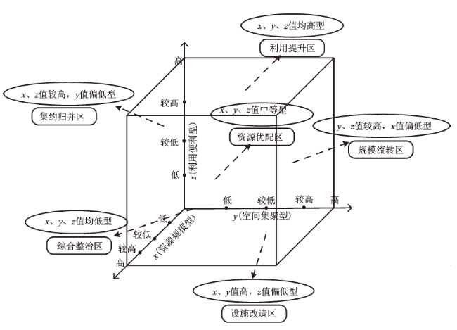
表2 耕地细碎化类型分区标准Table 2 Partition criteria of cultivated land fragmentation |
| 耕地细碎化类型分区 | 魔方单元组合 |
|---|---|
| 利用提升区 | (4,4,4)(4,4,3)(4,3,4)(4,3,3)(3,4,3)(3,4,4)(3,3,4)(3,3,3) |
| 集约归并区 | (4,1,4)(4,2,4)(4,1,3)(3,2,3)(3,2,4)(3,1,4)(3,1,3)(4,2,3)(2,1,4)(4,1,2)(4,2,2)(2,2,4) |
| 设施改造区 | (4,4,1)(4,4,2)(4,3,1)(4,3,2)(3,4,1)(3,4,2)(3,3,1)(3,3,2)(4,2,1)(2,4,1) |
| 规模流转区 | (1,4,4)(1,4,3)(1,3,4)(1,3,3)(2,4,4)(2,4,3)(2,3,4)(2,3,3)(1,2,4)(1,4,2)(2,4,2) |
| 资源优配区 | (3,1,2)(3,2,1)(2,1,3)(2,3,1)(1,2,3)(1,3,2)(2,2,3)(3,2,2)(2,3,2) |
| 综合整治区 | (1,1,1)(1,1,2)(1,2,1)(1,2,2)(2,1,2)(2,2,1)(2,1,1)(2,2,2)(1,1,3)(1,1,4)(1,3,1)(1,4,1)(3,1,1)(4,1,1) |
| [1] |
王道骏, 陈英, 贾首杰, 等. 基于景观格局指数的耕地细碎化研究——以甘肃省临夏北塬地区为例[J]. 中国农学通报, 2014,30(32):184-188.
[
|
| [2] |
王秀清, 苏旭霞. 农用地细碎化对农业生产的影响——以山东省莱西市为例[J]. 农业技术经济, 2002(2):2-7.
[
|
| [3] |
赵锐锋, 王福红, 张丽华, 等. 黑河中游地区耕地景观演变及社会经济驱动力分析[J]. 地理科学, 2017,37(6):920-928.
[
|
| [4] |
赵元, 胡月明, 张新长, 等. 农村居民点耕作距离空间分布特征估测分析[J]. 地理科学, 2016,36(5):760-765.
[
|
| [5] |
国土资源部土地整理中心. 中国土地整治发展研究报告(2014版) No. 1[M]. 北京: 社会科学文献出版社, 2014.
[ Land Consolidation Center of Ministry of Land and Resources . Research report on the development of land consolidation in China (2014 Edition) No.1. Beijing: Social Sciences Academic Press, 2014.]
|
| [6] |
河南省国土资源厅. 河南省土地开发整理工程建设标准[M]. 郑州: 黄河水利出版社, 2010.
[ Department of Land and Resources of Henan Province. Construction standard of land development and consolidation project in Henan. Zhengzhou: The Yellow River Water Conservancy Press, 2010.]
|
| [7] |
孙雁, 刘友兆. 基于细碎化的土地资源可持续利用评价——以江西分宜县为例[J]. 自然资源学报, 2010,25(5):802-810.
[
|
| [8] |
|
| [9] |
|
| [10] |
|
| [11] |
周应堂, 王思明. 中国土地零碎化问题研究[J]. 中国土地科学, 2008,22(11):50-54.
[
|
| [12] |
郭硕, 杨伟州, 魏明欢, 等. 基于地理加权回归的青龙满族自治县耕地细碎化及影响因子分析[J]. 水土保持研究, 2017,24(3):264-269.
[
|
| [13] |
李鑫, 欧名豪, 马贤磊. 基于景观指数的细碎化对耕地利用效率影响研究——以扬州市里下河区域为例[J]. 自然资源学报, 2011,26(10):1758-1767.
[
|
| [14] |
陈红宇, 朱道林, 郧文聚, 等. 嘉兴市耕地细碎化和空间集聚格局分析[J]. 农业工程学报, 2012,28(4):235-242.
[
|
| [15] |
文高辉, 杨钢桥, 汪文雄, 等. 基于农户视角的耕地细碎化程度评价——以湖北省“江夏区-咸安区-通山县”为例[J]. 地理科学进展, 2016,35(9):1129-1143.
[
|
| [16] |
封志明, 李香莲. 耕地与粮食安全战略: 藏粮于土, 提高中国土地资源的综合生产能力[J]. 地理学与国土研究, 2000(3):1-5.
[
|
| [17] |
孙雁, 赵小敏. 分宜县土地细碎化的中观尺度研究[J]. 中国土地科学, 2010,24(4):25-31.
[
|
| [18] |
叶菁, 谢巧巧, 谭宁焱. 基于生态承载力的国土空间开发布局方法研究[J]. 农业工程学报, 2017,33(11):262-271.
[
|
| [19] |
龙花楼, 邹健, 李婷婷, 等. 乡村转型发展特征评价及地域类型划分——以“苏南-陕北”样带为例[J]. 地理研究, 2012,31(3):495-506.
[
|
| [20] |
郭艳, 张成才, 康鸳鸯. 河南省经济发展的国土空间评价分区研究[J]. 地理研究, 2015,34(12):2320-2328.
[
|
| [21] |
孙伟, 陈雯, 陈诚. 水环境协同约束分区与产业布局引导研究—以江苏省为例[J]. 地理学报, 2010,65(7):819-827.
[
|
/
| 〈 |
|
〉 |