
基于景观生态安全格局构建的城镇空间扩展模式研究——以江苏沿海地区为例
|
杨清可(1986−),男,山东滕州人,讲师,从事区域规划与土地利用研究。E-mail: yangqingke66@163.com |
收稿日期: 2020-03-08
修回日期: 2020-04-10
网络出版日期: 2021-07-15
基金资助
国家重点研发计划(2018YFD1100101)
江苏省自然科学基金项目(BK20170876)
江苏省高校哲学社会科学研究项目资助(2020SJA0276)
版权
Urban Spatial Expansion Mode Based on the Construction of Landscape Ecological Security Pattern: A Case of the Coastal Area of Jiangsu
Received date: 2020-03-08
Revised date: 2020-04-10
Online published: 2021-07-15
Supported by
National Key R&D Program of China(2018YFD1100101)
Jiangsu Natural Science Foundation(BK20170876)
The Philosophical and Social Sciences Foundation of the Jiangsu Higher Education Institutions of China(2020SJA0276)
Copyright
杨清可 , 王磊 , 李永乐 , 秦贤宏 . 基于景观生态安全格局构建的城镇空间扩展模式研究——以江苏沿海地区为例[J]. 地理科学, 2021 , 41(5) : 737 -746 . DOI: 10.13249/j.cnki.sgs.2021.05.001
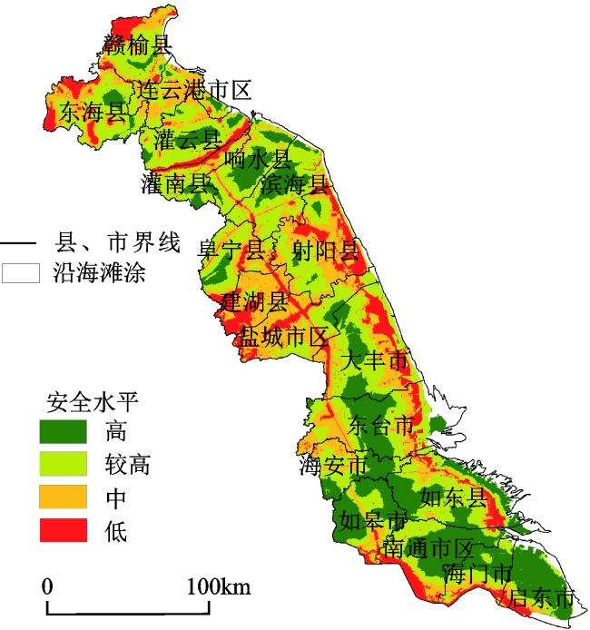
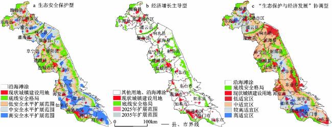
The importance of ecological security space has attracted more and more attention in the top-level design of urban spatial expansion in China. That’s very necessary to identify security issues and key ecological factors from regional scale, construct landscape ecological security pattern and analyze urban spatial expansion mode, which can provide policy reference for the upcoming territorial spatial planning. Taking the coastal areas of Jiangsu as an example, based on the theory of ‘process-pattern’ of landscape ecology, this article constructs four single ecological security patterns for the maintenance of basic ecosystem services such as landform, water conservation, biodiversity and recreational landscape. According to the ‘minimum-maximum constraint’ criterion, by overlapping mosaic operations, four different levels of comprehensive ecological security patterns are constructed, and the low security level zone that needs to be strictly protected, then the high security level that could be planned as a key development zone in future. Meanwhile, use MCR model, set up and compare the impact of different models on urban spatial expansion, such as ‘ecological security protection type’ ‘economic growth dominant type’ and ‘ecological and economic coordination type’. The results show that the coordinated model of ‘ecological protection and economic development’ can better balance the ‘ecological-social-economic’ benefits. This model can reasonably determine the space for urban construction and industrial development. It is the optimal model for the orderly and healthy development of cities and towns in the future, and also of great significance for optimizing the spatial layout of cities and towns and improving the comprehensive benefits of construction land development.

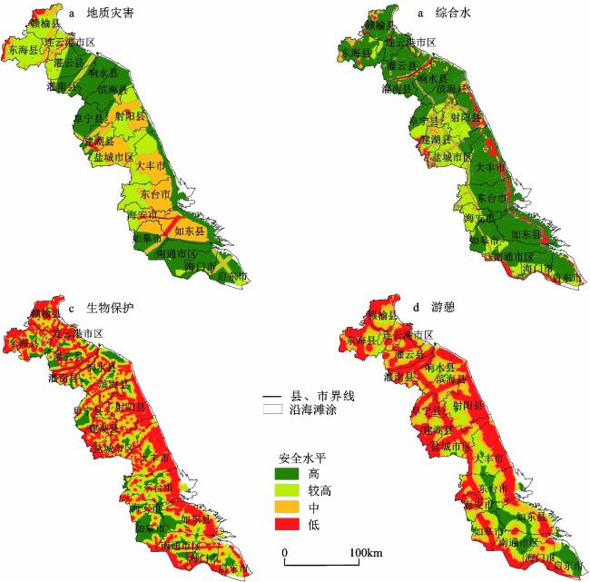
表1 区域地形地貌安全内容及等级划分Table 1 The context and classification of regional topography and landform |
| 生态安全因子 | 低安全水平 | 中安全水平 | 较高安全水平 | 高安全水平 | 权重 |
| 抗震烈度 | 6° | 7° | 8° | >8° | 0.2345 |
| 活动断裂带 | 0~2 km | 2~5 km | 5~10 km | >10 km | 0.1324 |
| 坍塌−滑坡灾害点 | >8 | 3~8 | 1~2 | <1 | 0.0633 |
| 植被覆盖 | NDVI<0.1 | 0.1≤NDVI<0.3 | 0.3≤NDVI<0.5 | NDVI≥0.5 | 0.1768 |
| 地面沉降 | >1 m | 0.2~1 m | 0.1~0.2 m | <0.1 m | 0.2834 |
| 灾害发育程度 | 严重沙土气化 | 中等沙土气化 | 轻度沙土气化 | 未沙土气化 | 0.1095 |
表2 3种安全水平下的防洪安全格局Table 2 Flood control safety patterns under three safety levels |
| 安全水平 | 洪水级别 | 缓冲区范围/m | 本文选用范围/m |
| 低安全水平10 a一遇 | 一般 | 0~50 | 30 |
| 中安全水平20 a一遇 | 较大 | 50~80 | 70 |
| 较高安全水平50 a一遇 | 大 | 80~150 | 120 |
| 高安全水平 | 无洪水威胁 | ||
表3 江苏沿海地区生境适宜性评价体系Table 3 Habitat suitability assessment system in the coastal area of Jiangsu |
| 评价因子 | 分级 | 阻力系数 | 权重 |
| 土地覆盖类型 | 河流、湖泊、滩涂 | 10 | 0.5 |
| 水库、坑塘、沟渠 | 8 | ||
| 有林地、其他林地 | 6 | ||
| 水田、水浇地、旱地 | 5 | ||
| 茶园、果园、其他园地、其他草地 | 4 | ||
| 设施农用地、田坎、农村道路、风景名胜地 | 3 | ||
| 交通用地 | 2 | ||
| 城镇工矿用地、水工建筑用地 | 1 | ||
| 距城镇、农村居民点距离 | >1 000 m | 10 | 0.3 |
| 500~1000 m | 6 | ||
| 0~500 m | 1 | ||
| 坡度 | 0°~5° | 10 | 0.2 |
| 5°~15° | 8 | ||
| 15°~25° | 4 | ||
| 25°~60° | 2 | ||
| 60°~90° | 1 |
表4 游憩过程阻力要素及阻力系数表Table 4 Resistance elements and resistance coefficient in recreation process |
| 阻力要素 | 分类 | 阻力系数 |
| 土地覆被类型 | 林地、草地 | 10 |
| 沿海滩涂 | 15 | |
| 其他林地、其他草地 | 20 | |
| 设施农用地、农村道路、田坎、沟渠、坑塘水面 | 25 | |
| 水田、水浇地、旱地、茶园、果园 | 30 | |
| 城镇工矿用地、水工建筑用地 | 50 | |
| 水系、湿地 | 河流、湖泊、水库、湿地 | 0 |
表5 城镇空间扩展源的分级及影响因素Table 5 Classification and influence factors of urban space sources |
| 扩展源等级(K) | 划分单元 | 行政等级 | 发展定位 | 土地开发强度/% | 人口密度/ (人/km2) | GDP总量/ 亿元 |
| Ⅰ级(0.6) | 南通城区、盐城城区、连云港城区 | 地级市 | 城市中心区,作为区域开发布局的极点 | 23.15 | 649.75 | 6344.78 |
| Ⅱ级(0.8) | 海门市、启东市、如皋市、海安市、东台市 | 县级市 | 作为区域开发的“多节点”,根据各自比较优势,合理分工,错位发展 | 18.19 | 634.30 | 4835.32 |
| Ⅲ级(1.0) | 如东县、响水县、滨海县、阜宁县、射阳县、建湖县、灌南县、东海县、灌云县 | 县 | 作为区域郊县,发展腹地,承载区域内外、发达地区的产业转移 | 17.66 | 509.72 | 4277.53 |
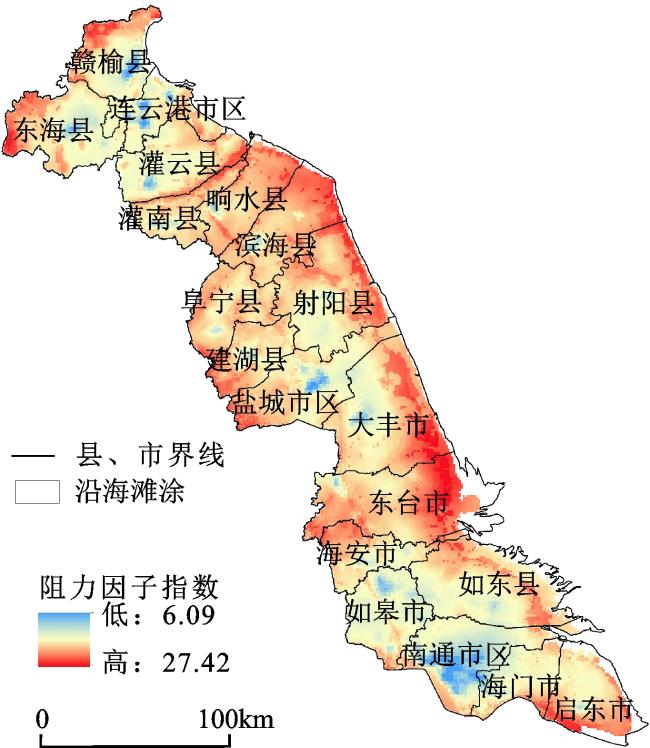
表6 城镇空间扩展的影响因子与阻力系数Table 6 Influencing factors and resistance coefficient of urban space expansion |
| 扩展类型 | 影响因子 | 权重 | 分级 | 阻力系数 |
| 阻力因子 | 生态安全保护格局 | 0.305 | 低安全格局 | 400 |
| 中安全格局 | 250 | |||
| 较高安全格局 | 100 | |||
| 高安全格局 | 10 | |||
| 动力因子 | 与交通干线的距离 | 0.091 | 0~200 m | 10 |
| 200~500 m | 50 | |||
| 500~1500 m | 200 | |||
| >1500 m | 400 | |||
| 与商业中心的距离 | 0.128 | 0~500 m | 10 | |
| 500~1500 m | 50 | |||
| 1500~2500 m | 200 | |||
| >2500 m | 400 | |||
| 与主要港口的距离 | 0.052 | 0~1 km | 1 | |
| 1~2 km | 50 | |||
| 2~4 km | 100 | |||
| >4 km | 500 | |||
| 与机场的距离 | 0.085 | 0~1 km | 10 | |
| 1~2.5 km | 50 | |||
| 2.5~5 km | 100 | |||
| >5 km | 500 | |||
| 政策因子 | 开发集聚区域 | 0.338 | 高值区 | 1 |
| 较高值区 | 20 | |||
| 中值区 | 50 | |||
| 较低值区 | 100 | |||
| 低值区 | 300 |
| 1 |
陆大道. 我国的城镇化进程与空间扩张[J]. 城市规划学刊, 2007, (4): 47-52.
Lu Dadao. Urbanization process and spatial sprawl in China[J]. Urban Planning Forum, 2007, (4): 47-52.
|
| 2 |
匡文慧. 城市土地利用/覆盖变化与热环境生态调控研究进展与展望[J]. 地理科学, 2018, 38 (10): 1643-1652.
Kuang Wenhui. Advance and future prospects of urban land use/cover change and ecological regulation of thermal environment[J]. Scientia Geographica Sinica, 2018, 38 (10): 1643-1652.
|
| 3 |
Peng J, Liu Y, Li T et al. Regional ecosystem health response to rural land use change: A case study in Lijiang City, China[J]. Ecological Indicators, 2017, 72 (1): 399-410.
|
| 4 |
Wang W, Guo H, Chuai X et al. The impact of land use change on the temporospatial variations of ecosystems services value in China and an optimized land use solution[J]. Environmental Science & Policy, 2014, 44 (12): 62-72.
|
| 5 |
Warren P S, Ryan R L, Lerman S B et al. Social and institutional factors associated with land use and forest conservation along two urban gradients in Massachusetts[J]. Landscape and Urban Planning, 2011, 102 (2): 82-92.
|
| 6 |
Liu Y, Song W, Deng X. Understanding the spatiotemporal variation of urban land expansion in oasis cities by integrating remote sensing and multi-dimensional DPSIR-based indicators[J]. Ecological Indicators, 2019, 96 (1): 23-37.
|
| 7 |
俞孔坚, 王思思, 李迪华, 等. 北京市生态安全格局及城市增长预景[J]. 生态学报, 2009, 29 (3): 1189-1204.
Yu Kongjian, Wang Sisi, Li Dihua et al. The function of ecological security patterns as an urban growth framework in Beijing[J]. Acta Ecologica Sinica, 2009, 29 (3): 1189-1204.
|
| 8 |
Liu Y, Zhang X, Kong X et al. Identifying the relationship between urban land expansion and human activities in the Yangtze River Economic Belt, China[J]. Applied Geography, 2018, 94 (3): 163-177.
|
| 9 |
彭建, 赵会娟, 刘焱序, 等. 区域生态安全格局构建研究进展与展望[J]. 地理研究, 2017, 36 (3): 407-419.
Peng Jian, Zhao Huijuan, Liu Yanxu et al. Research progress and prospect on regional ecological security pattern construction[J]. Geographical Research, 2017, 36 (3): 407-419.
|
| 10 |
刘稼丰, 焦利民, 董婷, 等. 一种新的城市景观扩张过程测度方法: 多阶邻接度指数[J]. 地理科学, 2018, 38 (11): 1741-1749.
Liu Jiafeng, Jiao Limin, Dong Ting et al. A novel measure approach of expansion process of urban landscape: Multi-order adjacency index[J]. Scientia Geographica Sinica, 2018, 38 (11): 1741-1749.
|
| 11 |
杨清可, 段学军, 金志丰, 等. 南通市建设用地扩张情景模拟与景观生态效应[J]. 地理科学, 2017, 37 (4): 528-536.
Yang Qingke, Duan Xuejun, Jin Zhifeng et al. Spatial scenario simulation and landscape ecological effect based on construction land expansion of Nantong City[J]. Scientia Geographica Sinica, 2017, 37 (4): 528-536.
|
| 12 |
彭建, 李慧蕾, 刘焱序, 等. 雄安新区生态安全格局识别与优化策略[J]. 地理学报, 2018, 73 (4): 701-710.
Peng Jian, Li Huilei, Liu Yanxu et al. Identification and optimization of ecological security pattern in Xiong'an New Area[J]. Acta Geographica Sinica, 2018, 73 (4): 701-710.
|
| 13 |
Cen X, Wu C, Xing X et al. Coupling intensive land use and landscape ecological security for urban sustainability: An integrated socioeconomic data and spatial metrics analysis in Hangzhou City[J]. Sustainability, 2015, 7 (2): 1459-1482.
|
| 14 |
陈昕, 彭建, 刘焱序, 等. 基于“重要性−敏感性−连通性”框架的云浮市生态安全格局构建[J]. 地理研究, 2017, 36 (3): 471-484.
Chen Xin, Peng Jian, Liu Yanxu et al. Constructing ecological security patterns in Yunfu City based on the framework of importance-sensitivity-connectivity[J]. Geographical Research, 2017, 36 (3): 471-484.
|
| 15 |
Su Y, Chen X, Liao J et al. Modeling the optimal ecological security pattern for guiding the urban constructed land expansions[J]. Urban Forestry & Urban Greening, 2016, 19 (9): 35-46.
|
| 16 |
谢花林, 李秀彬. 基于GIS的区域关键性生态用地空间结构识别方法探讨[J]. 资源科学, 2011, 33 (1): 112-119.
Xie Hualin, Li Xiubin. A method for identifying spatial structure of regional critical ecological land based on GIS[J]. Resources Science, 2011, 33 (1): 112-119.
|
| 17 |
彭保发, 郑俞, 刘宇. 耦合生态服务的区域生态安全格局研究框架[J]. 地理科学, 2018, 38 (3): 361-367.
Peng Baofa, Zheng Yu, Liu Yu. Coupling ecosystem services and regional ecological security pattern[J]. Scientia Geographica Sinica, 2018, 38 (3): 361-367.
|
| 18 |
文雅, 龚建周, 胡银根, 等. 基于生态安全导向的城市空间扩展模拟与分析[J]. 地理研究, 2017, 36 (3): 518-528.
Wen Ya, Gong Jianzhou, Hu Yingen et al. Simulation and analysis of urban land expansion conducted by ecological security[J]. Geographical Research, 2017, 36 (3): 518-528.
|
| 19 |
梁保平, 雷艳, 覃业努, 等. 快速城市化背景下广西典型城市景观空间格局动态比较研究[J]. 生态学报, 2018, 38 (12): 4526-4536.
Liang Baoping, Lei Yan, Qin Yenu et al. Comparison of changing landscape patterns in the rapidly urbanizing cities of Guangxi[J]. Acta Ecologica Sinica, 2018, 38 (12): 4526-4536.
|
| 20 |
李平星. 广西西江经济带生态重要性分区及其与建设用地的空间叠置关系[J]. 生态学杂志, 2012, 31 (10): 2651-2656.
Li Pingxing. Ecological importance zoning and its spatial overlay relationship with construction lands in Xijiang River Economic Belt of Guangxi, south China[J]. Chinese Journal of Ecology, 2012, 31 (10): 2651-2656.
|
| 21 |
丛佃敏, 赵书河, 于涛, 等. 综合生态安全格局构建与城市扩张模拟的城市增长边界划定——以天水市规划区(2015—2030年)为例[J]. 自然资源学报, 2017, 33 (1): 14-26.
Cong Dianmin, Zhao Shuhe, Yu Tao et al. Urban growth boundary delimitation method integrating comprehensive ecological security pattern and urban expansion simulation—A case study of planning areas in Tianshui City (2015-2030)[J]. Journal of Natural Resources, 2017, 33 (1): 14-26.
|
| 22 |
Peng J, Pan Y, Liu Y et al. Linking ecological degradation risk to identify ecological security patterns in a rapidly urbanizing landscape[J]. Habitat International, 2018, 71 (6): 110-124.
|
| 23 |
苏泳娴, 张虹鸥, 陈修治, 等. 佛山市高明区生态安全格局和建设用地扩展预案[J]. 生态学报, 2013, 33 (5): 1524-1534.
Su Yongxian, Zhang Hongou, Chen Xiuzhi et al. The ecological security patterns and construction land expansion simulation in Gaoming[J]. Acta Ecologica Sinica, 2013, 33 (5): 1524-1534.
|
| 24 |
刘建鑫. 基于区域生态安全格局的沈本空间一体化研究[D]. 北京: 中国科学院大学, 2014.
Liu Jianxin. Study of Shen-ben spatial intergration based on regional ecological security pattern. Beijing: University of Chinese Academy of Sciences, 2014.
|
| 25 |
叶玉瑶, 苏泳娴, 张虹鸥, 等. 生态阻力面模型构建及其在城市扩展模拟中的应用[J]. 地理学报, 2014, 69 (4): 485-496.
Ye Yuyao, Su Yongxian, Zhang Hongou et al. Ecological resistance surface model and its application in urban expansion simulations[J]. Acta Geographica Sinica, 2014, 69 (4): 485-496.
|
| 26 |
Yin H, Kong F, Yang X et al. Exploring zoning scenario impacts upon urban growth simulations using a dynamic spatial model[J]. Cities, 2018, 81 (11): 214-229.
|
| 27 |
江苏省统计局. 中国统计年鉴[M]. 北京: 中国统计出版社, 2001-2016.
National Bureau of Statistics. Jiangsu statistical yearbook. Beijing: China Statistical Publishing House, 2001-2016.
|
| 28 |
胡望舒, 王思思. 基于焦点物种的北京市生物保护安全格局规划[J]. 生态学报, 2010, 30 (16): 4266-4276.
Hu Wangshu, Wang Sisi. Biological conservation security patterns plan in Beijing based on the focal species approach[J]. Acta Ecologica Sinica, 2010, 30 (16): 4266-4276.
|
| 29 |
邱硕, 王宇欣, 王平智, 等. 基于MCR模型的城镇生态安全格局构建和建设用地开发模式[J]. 农业工程学报, 2018, 34 (17): 257-265.
Qiu Shuo, Wang Yuxin, Wang Pingzhi et al. Construction of urban ecological security pattern and construction land development based on MCR model[J]. Transactions of the Chinese Society of Agricultural Engineering, 2018, 34 (17): 257-265.
|
/
| 〈 |
|
〉 |