
莱州湾南岸中全新世聚落遗址时空分布特征及其环境背景
作者简介:赵强(1977-),副教授,研究方向为全新世环境演化。E-mail: stu_zhaoq@ujn.edu.cn
收稿日期: 2017-07-11
要求修回日期: 2018-01-28
网络出版日期: 2018-09-10
基金资助
国家自然科学基金项目(41471160)、济南大学教学研究项目(XKY1310)资助
Spatial and Temporal Distribution Characteristics and Environmental Background of the Middle Holocene Settlements in the South Bank of Laizhou Bay
Received date: 2017-07-11
Request revised date: 2018-01-28
Online published: 2018-09-10
Supported by
National Natural Science Foundation of China (41471160), Teaching and Research Project of University of Jinan (XKY1310).
Copyright
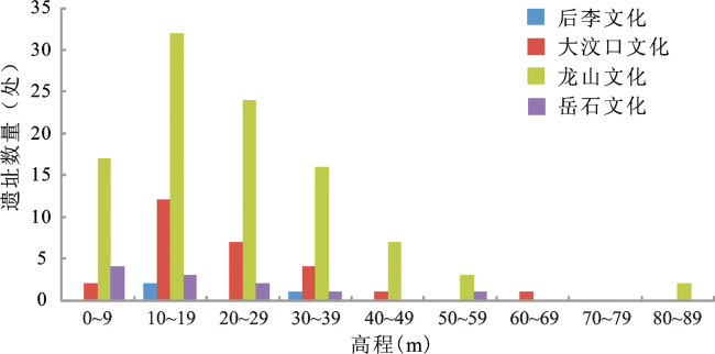
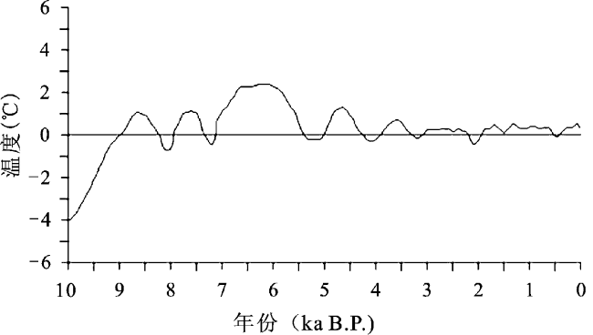
基于ArcGIS10.3平台对莱州湾南岸中全新世聚落遗址的高程、坡度、坡向、濒河度等指标进行分析,得出该时期聚落遗址的时空分布及演变特征,并结合全新世莱州湾南岸的环境背景,探讨全新世环境演变对聚落遗址分布及演变的影响。研究表明:① 全新世莱州湾南岸的聚落遗址数量、出现频率及在总数中的比重基本呈现明显的先增后降的倒V型(非对称)变化趋势。② 遗址高程分布具有一定的规律性,几乎所有时期的遗址点均分布于高程范围在0~29 m的地区,而大汶口文化时期遗址高程分布范围为10~29 m。从坡度来看,聚落遗址主要分布于坡度范围在0~4°的平缓地区;从坡向来看,古人大多集中在南向、东南向和西南向的位置。后李文化至龙山文化时期,河流对聚落选址的影响程度逐渐降低。③ 8.5~6.9 ka B.P.气候总体进入温暖期,且冷暖波动,干湿交替,后李文化由此得到发展;6.9~4.5 ka B.P.出现了短暂的降温,但整体较温和,优越的自然条件促进了大汶口文化的发展;4.5~4.0 ka B.P.左右气候条件较大汶口文化时期略干,但在此基础上新石器文化仍得到进一步发展,并于龙山文化时期进入鼎盛阶段;4.0 ka B.P.左右气候突变,出现剧烈降温事件,变化幅度超出了人类的适应能力,岳石文化随之衰落。④ 海水入侵限制了人类活动,而古湖泊和古河道的形成为古人生活质量的提高创造了天然条件。
赵强 , 邹春辉 , 王爽 , 高倩 . 莱州湾南岸中全新世聚落遗址时空分布特征及其环境背景[J]. 地理科学, 2018 , 38(9) : 1560 -1569 . DOI: 10.13249/j.cnki.sgs.2018.09.020
Based on the ArcGIS10.3 platform, the elevation, slope, aspect and the river distance of the Holocene settlement sites in the south bank of Laizhou Bay are analyzed, the temporal-spatial distribution and evolution characteristics of the settlement sites are obtained. Combined with the environmental background in the South Bank of Laizhou Bay, to explore the influence of Holocene environmental evolution on the distribution and evolution of settlement sites. The results show that: 1) The quantity, frequency and proportion of the number of settlements in the study area are firstly increasing and then decreasing in a V-type (asymmetric) trend. 2) The distribution of the site has a certain regularity, almost all the sites are located in the elevation of the range of 0-29 m in the area, while the Dawenkou culture period is 10-29 m. This difference is closely related to the Huanghua transgression of the middle Holocene. From the slope, the settlement sites are mainly distributed in the range of 0°-4° in the gentle areas; from the aspect, the ancients are mostly concentrated in the direction of south, southeast and southwest. From Houli culture to Longshan culture, the influence of river distance to settlements gradually decreased, and the ability of the ancients to adapt environment gradually increased. 3) 8.5-6.9 ka B.P., the climate goes into warm, and the cold and warm fluctuations, dry and wet alternately, thus Houli culture gets to be developed; 6.9-4.5 ka B.P. appears a brief cooling, but the overall more moderate, superior natural conditions promotes the growth of Dawenkou culture; 4.5-4.0 ka B.P., comparied with Dawenkou culture period, climate conditions are slightly drier, but Neolithic culture is still further development, and entering the peak stage in the Longshan culture period; around 4.0 kaBP, the climate suddenly changes and emerges violent cooling events. The range of change exceeds the human adaptation ability, leading to the decline of Longshan culture. 4) Seawater intrusion restricts human activities, but the formation of ancient lakes and rivers creates the natural conditions for the improvement of the quality of life for the ancients.
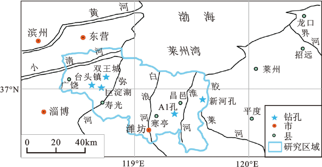
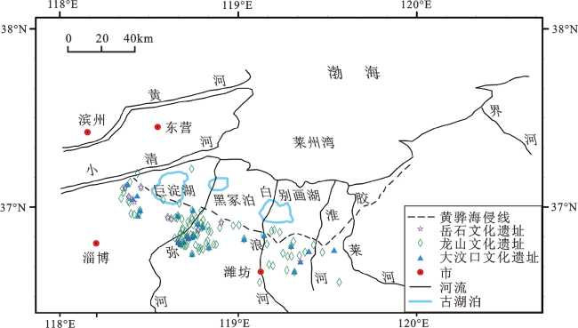
Fig.1 Map of the study area and location of profiles图1 研究区概况与钻孔位置 |
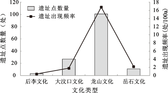
Fig.2 The quantity distribution of the middle Holocene settlement sites in the study area图2 莱州湾南岸中全新世聚落遗址数量分布 |
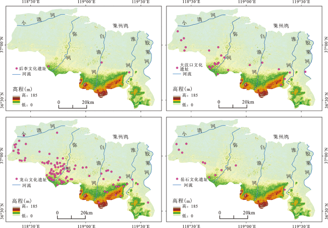
Fig.3 Distribution of the middle Holocene settlement sites in the study area图3 莱州湾南岸中全新世聚落遗址分布 |
Fig.4 Elevation distribution of the middle Holocene settlement sites图4 中全新世聚落遗址高程分布 |
Fig.5 Relationship between settlement sites and Huanghua transgression图5 聚落遗址分布与黄骅海侵关系 |
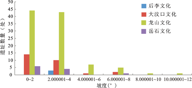
Fig.6 Slope distribution of the middle Holocene settlement sites图6 中全新世聚落遗址坡度分布 |
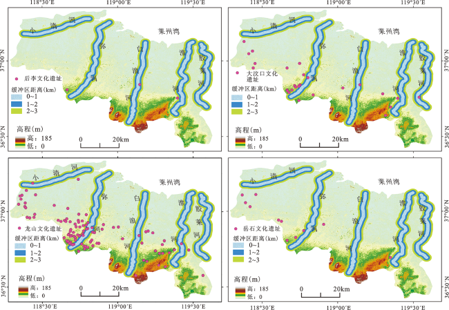
Fig.7 Distribution of river buffers in the middle Holocene settlement sites图7 中全新世聚落遗址河流缓冲区分布 |
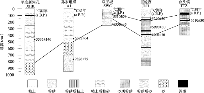
Fig.8 Profiles comparison of the south bank of Laizhou Bay图8 莱州湾南岸剖面对比 |
Fig.9 The temperature fluctuation since the Holocene in the study area(Modified according to the literature [19])图9 莱州湾南岸全新世以来气温波动曲线(据文献[19]修改) |
Table 1 Correspondence between settlement sites and paleoenvironment on the south bank of Laizhou Bay表1 莱州湾南岸聚落遗址与古环境对应信息 |
| 文化时期 | 遗址 | 环境信息 | 出处 |
|---|---|---|---|
| 后李文化 | 前埠下遗址 | 1.遗址周围生长大量适宜暖湿环境的植物;2.丽蚌、蓝蚬等动物遗体,反映出前埠下一带附近为森林草甸环境;3.气候条件适宜,温和湿润; 4.先民在滨河临海附近进行渔猎农耕活动。 | [20,21] |
| 大汶口文化 | 前埠下遗址 | 1.干凉气候植物标本增多,暖湿气候植物标本减少; 2.水生植物较多,且存在大量的芦苇,表明周围存在丰富的水资源。 | [22] |
| 五村遗址 | 据调查反映年平均气温比现在约高2~4℃,适宜先民从事农耕和捕捞。 | [23] | |
| 傅家遗址 | 1.遗址表层为黄色土,文化层为红褐或灰褐色;2.遗址周围分布有30~140 m宽的水洼地,说明早期气候干旱,后来湿润多水,形成时期较长的水洼地,居民居住在高地;3. 遗址中出现属于粟类农业的小米。 | [24] | |
| 龙山文化 | 鲁家口遗址 | 1坐落在莱州湾南岸低湿的冲积平原;2捕捞活动在经济生活中有一定的重要性,但活动范围仅限在河流和入海口附近,未深入海洋作业。 | [25,26] |
| 郭井子遗址 | 1.郭井子遗址坐落在贝壳堤上,此贝壳堤14C测年为5.0 ka B.P.;2.遗迹包含大量草木灰、烧土和白色块状物堆积;3.有少量文蛤、毛蛤遗骸,反映海滩—滨岸沉积环境。 | [27,28] |
| [1] |
|
| [2] |
|
| [3] |
|
| [4] |
|
| [5] |
|
| [6] |
|
| [7] |
|
| [8] |
|
| [9] |
|
| [10] |
|
| [11] |
|
| [12] |
|
| [13] |
|
| [14] |
国家文物局. 《中国文物地图集•山东分册》[M]. 北京: 中国地图出版社, 2007.
[National Heritage Board. Atlas of China's cultural relics • Shandong Branch. Beijing: China Map Publishing House, 2007.]
|
| [15] |
[
|
| [16] |
[
|
| [17] |
[
|
| [18] |
[
|
| [19] |
[
|
| [20] |
[
|
| [21] |
[
|
| [22] |
[
|
| [23] |
[
|
| [24] |
[
|
| [25] |
[
|
| [26] |
[
|
| [27] |
[
|
| [28] |
[
|
| [29] |
[
|
| [30] |
[
|
| [31] |
[
|
| [32] |
[
|
| [33] |
[
|
/
| 〈 |
|
〉 |