
鲁运河沿线古镇空间发展演变特征及驱动因素
|
赵亚琛(1990—),女,山东莱芜人,助研,博士,主要从事古镇聚落空间保护与发展研究。E-mail: aachen.zhao@sdu.edu.cn |
收稿日期: 2022-09-14
修回日期: 2022-11-03
录用日期: 2023-06-07
网络出版日期: 2023-10-12
基金资助
国家自然科学基金项目(52208013)
山东省自然科学基金项目(ZR2022QE292)
福建省自然科学基金项目(2022J05126)
版权
Characteristics and driving factors of spatial development and evolution of ancient towns along the Lu Canal
Received date: 2022-09-14
Revised date: 2022-11-03
Accepted date: 2023-06-07
Online published: 2023-10-12
Supported by
National Natural Science Foundation of China(52208013)
National Natural Science Foundation of Shandong Province(ZR2022QE292)
National Natural Science Foundation of Fujian Province(2022J05126)
Copyright
以沿鲁运古镇街巷空间以及公共节点空间作为研究对象,选取离散数学图论和空间句法相结合的方法,运用拓扑分析软件Pajek和空间句法软件Depthmap,提取沿运古镇空间的拓扑结构及相关参数,通过所得的结构特征以及参数值解读分析沿运古镇聚落空间的饱和度层级,结合空间特征点要素以及空间特征进一步分析聚落空间发展演变的特征规律,并揭示其空间演变的驱动因素,结果表明:① 运河水环境在沿运古镇空间发展中具有核心作用空间,其空间最初的发展演变主要集中于运河水环境空间发展;② 在沿运古镇空间发展演变的过程中,水利技术、经济产业、社会制度、历史文化等对空间发展演变均具有一定的影响作用;③ 近现代以来,区域环境、社会文化以及陆路交通方式的转变,加之漕运废止,促使沿运古镇空间发展逐渐停滞,水环境空间的核心作用逐渐减弱,道路空间指向性发展逐渐明显。④ 水环境水利工程技术、经济产业技术、国家政治经济力量以及运河文化等驱动因素对沿运古镇空间演变具有重要影响作用。
赵亚琛 , 张兵华 . 鲁运河沿线古镇空间发展演变特征及驱动因素[J]. 地理科学, 2023 , 43(9) : 1629 -1639 . DOI: 10.13249/j.cnki.sgs.2023.09.013
This study takes the street space and public node space of ancient towns along the Lu Canal as the research object. After method comparison, the method of combining discrete mathematical graph theory and spatial syntax is selected. The topological structure and relevant parameters of the space are extracted by using the topological analysis software Pajek and the spatial syntax software Depthmap. The saturation level of the settlement space is analyzed through the obtained structural characteristics and parameter values. Combined with the spatial feature point elements and spatial features, the paper further analyzes the characteristics of the development and evolution of the settlement space, and reveals the driving factors of its spatial evolution. The results show that: 1) The canal water environment plays a key role in the spatial development of the ancient towns along the Lu Canal, and the initial development and evolution of the space are mainly concentrated on the spatial development of the river environment; 2) In the process of spatial development and evolution of ancient towns along the Lu Canal, water conservancy technology, economic industry, social system, history and culture have certain influence on spatial development and evolution; 3) Since modern times, the transformation of regional environment, political system, social culture and land transportation mode has caused the spatial development of the ancient town to gradually stagnate, the core role of water environment space has gradually weakened, and the directional development of road space has gradually become obvious. 4) Driving factors such as water environment, water conservancy engineering technology, economic and industrial technology, national political and economic forces, and canal culture have an important impact on the spatial evolution of ancient towns along the canal.
表1 鲁运河沿线古镇历史文化节点汇总Table 1 Summary of historical and cultural nodes of ancient towns along the Lu Canal |
| 古镇 | 编号 | 建筑名称 | 时间 | 建筑结构 | 占地面积/m2 | 建筑面积/m2 | 历史文化节点说明 |
| 注:—为无数据;表内数据、资料由济宁市规划局、阳谷县规划局、台儿庄区政府提供;因台儿庄古镇历史文化空间节点多为后期修缮,故图表中不做列举说明。 | |||||||
| 阿城古镇 | 1 | 海会寺 | 清代 | 砖石 | 66000 | — | 建于康熙四十八年,位于海会寺路和阿吕路交界出处 |
| 2 | 阿城闸 | 元代 | 砖石 | — | — | 建于元大都时期,位于海会寺路和东大街交汇处 | |
| 3 | 清真寺 | 明代 | 砖木 | 300 | — | 始建于明代,位于阿吕路和三孔桥路交汇处。 | |
| 4 | 盐运司 | 清代 | 砖木 | 2600 | 383.8 | 建于乾隆十三年,位于七级古镇东部,三孔桥路,连接东西陆路交通和南北水路交通 | |
| 5 | 清朝石碑 | 清朝 | — | — | — | 位于阿城古镇东南部区域滨河路 | |
| 七级古镇 | 1 | 七级古码头 | 清代 | 砖石 | — | — | 七级古码头位于古镇中桥北侧,修建于乾隆十年 |
| 2 | 狄家药铺 | 清代中期 | 砖木 | 300 | — | 又名“春和堂”,位于古镇古城路北侧 | |
| 3 | 翟家祠堂 | 明代 | 砖木 | 600 | — | 始建于明朝万历年间,位于七级中桥东侧,古镇路南部,飞檐抱柱式古建筑 | |
| 4 | 一碑担两 间茶馆 | 清代中期 | 砖木 | 50 | 383.8 | 位于七级中桥东侧,古镇路南侧,西临狄家药铺 | |
| 5 | 七级百货 | 民国时期 | 砖混 | 100 | 287.63 | 位于七级中桥东侧,古镇路北侧,西临翟家祠堂 | |
| 6 | 八卦楼 | 民国时期 | 砖混 | 200 | 541.5 | 位于七级中桥东侧,古镇路南侧,西临一碑担两间茶馆 | |
| 7 | 七级合作社 | 20世纪50年代 | 砖石 | 60 | 106.9 | 位于古镇南部,七级中桥东侧,运河老街东侧,西临一碑担两间茶馆 | |
| 8 | 七级供销社 | 20世纪50年代 | 砖石 | 50 | 92.4 | 位于古镇南部,七级中桥东侧,运河老街西侧 | |
| 9 | 七级运河下闸 | 清代 | 砖石 | — | — | 用于连接顺河东街与顺河西街,古城路东侧 | |
| 张秋古镇 | 1 | 运河石桥 | 清代 | 砖石 | — | — | 运河石桥由千余块石刻构成,位于城隍庙街,连接运河东西两侧 |
| 2 | 城隍庙大殿 | 清代 | 砖木 | 600 | — | 始建于清代,位于尚书街西侧,靠近城隍庙街南侧 | |
| 3 | 陈家旧宅 | 清代 | 砖木 | 20000 | — | 建于康熙二年,宅院共五进院落,位于城隍庙街与黄道街交汇处 | |
| 4 | 清真寺 | 清代 | 砖木 | 573.7 | 383.8 | 位于古镇西南部,圣希街南侧和义庙街北侧区域 | |
| 5 | 关帝庙 | 清代 | 砖木 | 1280 | 541.5 | 位于运河东部,靠近城隍庙街北侧 | |
| 6 | 码头遗址 | 清代 | 砖木 | — | — | 张秋镇为运河沿线上重要的商贸货运中转站,位于古镇西部区域,黄道路北侧 | |
| 7 | 任仙祠 | 清代 | 砖木 | 531.6 | 213.4 | 位于古镇西南部区域,义庙街北侧 | |
| 南旺古镇 | 1 | 大运河分水龙王庙建筑群 | 明初-清咸 丰年间 | 大型砖木 | 1474.6 | — | 为纪念运河史上重大的水利工程形成的运河沿线上最宏大的纪念性建筑群,位于南旺大街和运河南路的围合区域内 |
| 2 | 鲁九公墓 | 周王朝 | 砖石 | 925.2 | — | 位于南旺古镇西部,国家重要的历史遗迹,具有周王朝历史资料的研究价值 | |
| 3 | 蚩尤冢 | 远古文明 | 砖石 | 764.1 | — | 东夷族后裔祭祀先祖的中心,位于南旺古镇西部 | |
| 南阳古镇 | 1 | 河神庙遗址(南阳书院) | 元代 | — | 1474.6 | — | 位于南阳古镇运河南岸,古镇西东部区域,南阳街和顺河西街交接区域 |
| 2 | 堂房 | 清代 | 砖木 | 764.1 | 80.1 | 位于古镇中部区域,运河西岸,南阳街,状元胡同北侧 | |
| 3 | 清代钱庄 | 清代 | 砖木 | 573.7 | 383.8 | 位于古镇中部区域,南阳街与鱼市南街交接区域 | |
| 4 | 康熙御宴坊 | 清代 | 砖木 | 515.3 | 54.1 | 位于古镇南部,运河西侧,靠近南阳街西部 | |
| 5 | 清真寺 | 明代 | 砖木 | 1396.6 | 171.2 | 位于古镇南部,运河西侧,靠近运河西街 | |
| 6 | 娘娘庙 | 清代 | 砖木 | 361.1 | 53.4 | 南阳古镇的寺庙建筑,书院街和牌坊街交接区域 | |
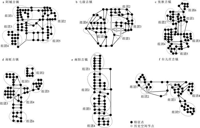
表2 鲁运河沿线古镇空间组团的句法参数值统计Table 2 Syntactic parameter values of spatial clusters of ancient towns along the Lu Canal |
| 古镇 | 空间组团 | 节点数 | CN平均值 | MD平均值 | Rn平均值 | CV平均值 |
| 注:CN值为连接值(Connectivity);MD值为深度值(Depth value);Rn值为整合度( Integration );CV值为控制值(Control value)。 | ||||||
| 阿城古镇 | 组团1 | 17 | 4.2156 | 5.8935 | 0.6833 | 1.2214 |
| 组团2 | 17 | 4.0101 | 6.1054 | 0.6279 | 1.2160 | |
| 组团3 | 11 | 3.5940 | 6.0963 | 0.6220 | 1.2109 | |
| 组团4 | 14 | 3.0027 | 6.9112 | 0.5804 | 1.1798 | |
| 组团5 | 11 | 3.1931 | 6.5278 | 0.5961 | 1.1801 | |
| 七级古镇 | 组团1 | 13 | 4.6633 | 5.0871 | 0.7066 | 1.2001 |
| 组团2 | 9 | 4.0278 | 5.3333 | 0.6736 | 1.1675 | |
| 组团3 | 6 | 3.2120 | 5.7854 | 0.6188 | 1.1333 | |
| 组团4 | 7 | 3.2059 | 6.2913 | 0.5925 | 1.1087 | |
| 组团5 | 9 | 3.8465 | 5.6790 | 0.6527 | 1.1421 | |
| 张秋古镇 | 组团1 | 12 | 4.5218 | 6.7465 | 0.5866 | 1.1233 |
| 组团2 | 11 | 4.1705 | 6.8809 | 0.6121 | 1.1151 | |
| 组团3 | 12 | 4.1140 | 7.4706 | 0.4247 | 1.1167 | |
| 组团4 | 14 | 3.2659 | 9.1066 | 0.2915 | 1.1189 | |
| 组团5 | 12 | 2.9333 | 9.2958 | 0.2767 | 1.1002 | |
| 组团6 | 6 | 1.2167 | 12.7911 | 0.1101 | 0.2853 | |
| 南旺古镇 | 组团1 | 17 | 4.2156 | 5.8935 | 0.6833 | 1.2214 |
| 组团2 | 17 | 4.0101 | 6.1054 | 0.6279 | 1.2160 | |
| 组团3 | 11 | 3.5940 | 6.0963 | 0.6220 | 1.2109 | |
| 组团4 | 14 | 3.0027 | 6.9112 | 0.5804 | 1.1798 | |
| 组团5 | 11 | 3.1931 | 6.5278 | 0.5961 | 1.1801 | |
| 南阳古镇 | 组团1 | 12 | 3.0538 | 4.2515 | 0.5238 | 1.1427 |
| 组团2 | 20 | 3.2135 | 4.6649 | 0.6010 | 1.1136 | |
| 组团3 | 15 | 3.2387 | 4.2916 | 0.5899 | 1.1280 | |
| 组团4 | 14 | 3.3421 | 4.7533 | 0.5916 | 1.0672 | |
| 台儿庄古镇 | 组团1 | 9 | 4.1313 | 6.5889 | 0.7391 | 1.1164 |
| 组团2 | 6 | 3.3902 | 7.0046 | 0.6121 | 1.1356 | |
| 组团3 | 12 | 4.6587 | 6.0121 | 0.7564 | 1.1341 | |
| 组团4 | 7 | 3.1248 | 8.6609 | 0.5807 | 1.1120 | |
| 组团5 | 12 | 2.8901 | 9.2897 | 0.4521 | 1.1089 | |
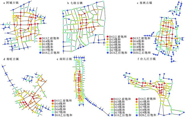
图3 鲁运河沿线古镇空间饱和度层级分析Dn表示该空间节点在第n步达到饱和 Fig. 3 Hierarchical analysis diagram of spatial saturation of the ancient towns along the Lu Canal |
表3 鲁运河沿线古镇空间演变阶段分析Table 3 Analysis of spatial evolution stages of ancient towns along the Lu Canal |
| 古镇 | 第一阶段 | 第二阶段 | 第三阶段 |
| 阿城古镇 | 沿小运河河道发展,并逐渐发展形成以三孔桥北部与阿吕路和滨河路围合而形成的空间区域 | 分别沿阿吕路与三孔桥路发展,形成古镇中南北方向和东西方向的重要道路,是发展最早的商业街巷空间 | 沿阿吕路和滨河路向南发展,具有道路发展的指向性,但是空间内街巷路网分布与空间特征点分布较零散 |
| 七级古镇 | 运河河道东侧的空间组团依托于运河东街以及运河老街首先发展,也是重要的漕运和货运码头 | 分别沿运河老街以及古城路向北以及向东发展;聚落北部和东部区域内的街巷路网较密集,历史痕迹较明显 | 沿古城路向西发展,沿运河河道发展形成古镇西侧的空间组团 |
| 张秋古镇 | 在靠近运河沿线的北部区域依托于漕运和货运首先发展;以顺河西街为最初的发展轴线,以城隍庙街、黄道街为连接纽带的区域空间 | 以黄道街、三道街为东西方向的发展轴线,并形成以城隍庙和陈家旧祠为重要空间节点的组团空间,其中尚书街也成为了古镇中较早的街巷空间 | 古镇顺应运河河道,以尚书街以及运河西街为轴线向南发展,沿圣希街连接运河的东西方向的区域空间 |
| 南旺古镇 | 大运河全运段承担的水利技术性功能远超过漕运货运码头的功能,其依托于运河水环境与分水龙王庙建筑群遗址而形成,并逐渐发展 | 沿南旺大街以及垂直于南旺大街的济梁大街和运河南路的方向逐渐发展,形成较大面积的居住空间组团 | 沿南旺大街向东北部区域延伸发展,在大运河与小汶河的河道围合区域内形成和发展,但空间布局较零散 |
| 南阳古镇 | 受地形环境的影响,沿运河河道两侧呈现线性布局的特征,两个区域空间由月河桥、状元桥和延德桥相互连接,而位于大运河河道西侧的区域空间的空间饱和度远高于大运河河道东侧的区域空间。古镇沿运河河道分别向北方向发展,进而形成空间线性布局特征 | 大运河东侧区域空间也开始逐渐发展 | |
| 台儿庄古镇 | 为方便运河漕运和商运,古镇以顺河街和丁字街为主要连接纽带的围合区域发展,运河码头空间的数量较多也较为集中 | 以越河街以及箭道为空间连接轴线,沿运河并且依托于运河码头的交通便利性,在组团空间内形成运河粮仓。同时,沿繁荣街向西部扩展 | 古镇沿繁荣街和运河沿线向东扩展,为民国发展的主要区域,存有修缮后的民国政府旧址以及大面积的抗战遗址 |
| [1] |
侯兵, 金阳, 胡美娟. 空间生产视角下大运河文化遗产重生的过程与机制——以扬州运河三湾生态文化公园为例[J]. 经济地理, 2022, 42(3): 160-171.
Hou Bing, Jin Yang, Hu Meijuan. The process and mechanism of the regeneration of the cultural heritage of the Grand Canal from the perspective of spatial production—Taking Yangzhou Canal Sanwan Ecological and Cultural Park as an example. Economic Geography, 2022, 42(3): 160-171.
|
| [2] |
李红波, 张小林. 国外乡村聚落地理研究进展及近今趋势[J]. 人文地理, 2012, 27(4): 103-108.
Li Hongbo, Zhang Xiaolin. Research progress and recent trends of rural settlement geography abroad. Human Geography, 2012, 27(4): 103-108.
|
| [3] |
陈宗兴, 陈晓键. 乡村聚落地理研究的国外动态与国内趋势[J]. 世界地理研究, 1994(1): 72-79.
Chen Zongxing, Chen Xiaojian. Foreign dynamics and domestic trends of rural settlement geography research. World Regional Studies, 1994(1): 72-79.
|
| [4] |
George W Hoffman. Transformation of rural settlement in Bulgaria[J]. Geographical Review, 1964, 54(l): 45-64.
|
| [5] |
Clark J K, Mcchesney R, Munroe D K et al. Spatial characteristics of exurban settlement pattern in the United States[J]. Landscape and Urban Planning, 2009, 90(3): 178-188.
|
| [6] |
Ristić D, Vukoičić D, Milinčić M. Tourism and sustainable development of rural settlements in protected areas—Example NP Kopaonik (Serbia)[J]. Land Use Policy, 2019, 89: 104231
|
| [7] |
刘天曌, 刘沛林, 王良健. 新型城镇化背景下的古村镇保护与旅游发展路径选择——以萱洲古镇为例[J]. 地理研究, 2019, 38(1): 133-145.
Liu Tianzhao, Liu Peilin, Wang Liangjian. Protection of ancient villages and towns and selection of tourism development path under the background of new urbanization—Taking Xuanzhou ancient town as an example. Geographical Research, 2019, 38(1): 133-145.
|
| [8] |
张凯, 马明. 内蒙古农牧交错带山地聚落空间形态研究[J]. 地域研究与开发, 2019, 38(6): 165-170.
Zhang Kai, Ma Ming. Study on the spatial morphology of mountain settlements in the agro pastoral ecotone of Inner Mongolia. Areal Research and Development, 2019, 38(6): 165-170.
|
| [9] |
刘志林, 丁银平, 角媛梅, 等. 中国西南少数民族聚居区聚落分布的空间格局特征与主控因素分析——以哈尼梯田区为例[J]. 地理科学进展, 2021, 40(2): 257-271.
Liu Zhilin, Ding Yinping, Jiao Yuanmei et al. Analysis of spatial pattern characteristics and main controlling factors of settlement distribution in ethnic minority inhabited areas in Southwest China—Taking Hani terrace area as an example. Progress in Geography, 2021, 40(2): 257-271.
|
| [10] |
赵思文, 胡希军, 陈琳, 等. “因航而兴”的湖南沅水流域古城镇空间分布特征及影响因素[J]. 经济地理, 2022, 42(6): 72-82.
Zhao Siwen, Hu Xijun, Chen Lin et al. Spatial distribution characteristics and influencing factors of ancient towns in the Yuanshui River Basin of Hunan Province "prospered by navigation". Economic Geography, 2022, 42(6): 72-82.
|
| [11] |
罗秀丽, 杨忍. 农村建设用地整治的空间生产机制及其效应——以广东省窑塘村为例[J]. 自然资源学报, 2022, 37(8): 2085-2101.
Luo Xiuli, Yang Ren. Spatial production mechanism and its effect of rural construction land renovation—Taking Yaotang Village in Guangdong Province as an example. Journal of Natural Resources, 2022, 37(8): 2085-2101.
|
| [12] |
刘淑虎, 张兵华, 冯曼玲, 等. 乡村风景营建的人文传统及空间特征解析——以福建永泰县月洲村为例[J]. 风景园林, 2020, 27(3): 97-102.
Liu Shuhu, Zhang Binghua, Feng Manling et al. Analysis of cultural traditions and spatial characteristics of rural landscape construction—Taking Yuezhou Village, Yongtai County, Fujian Province as an example. Landscape Architecture, 2020, 27(3): 97-102.
|
| [13] |
张玉坤, 李松洋, 李哲. 明长城居庸关防区军事聚落空间布局研究[J]. 西部人居环境学刊, 2022, 37(2): 107-113.
Zhang Yukun, Li Songyang, Li Zhe. Research on the spatial layout of military settlements in Juyong Pass of the Ming Great Wall. Journal of Human Settlements in West China, 2022, 37(2): 107-113.
|
| [14] |
李骞国, 石培基, 刘春芳, 等. 黄土丘陵区乡村聚落时空演变特征及格局优化——以七里河区为例[J]. 经济地理, 2015, 35(1): 126-133.
Li Qianguo, Shi Peiji, Liu Chunfang et al. Spatial and temporal evolution characteristics and pattern optimization of rural settlements in Loess Hilly Area—Taking Qilihe District as an example. Economic Geography, 2015, 35(1): 126-133.
|
| [15] |
杨凯悦, 宋永永, 薛东前. 黄土高原乡村聚落用地时空演变与影响因素[J]. 资源科学, 2020, 42(7): 1311-1324.
Yang Kaiyue, Song Yongyong, Xue Dongqian. Temporal and spatial evolution and influencing factors of rural settlement land on the Loess Plateau. Resources Science, 2020, 42(7): 1311-1324.
|
| [16] |
曹润, 杨朝现, 刘勇, 等. 基于生态保护格局的丘陵山区乡村聚落空间重构策略[J]. 生态与农村环境学报, 2019, 35(6): 689-697.
Cao Run, Yang Chaoxian, Liu Yong et al. Spatial reconstruction strategy of rural settlements in hilly and mountainous areas based on ecological protection pattern. Journal of Ecology and Rural Environment, 2019, 35(6): 689-697.
|
| [17] |
冯德东, 冯应斌, 赵玲珑, 等. 特色保护类村域农村居民点空间重构探析[J]. 地理科学进展, 2022, 41(5): 825-837.
Feng Dedong, Feng Yingbin, Zhao Linglong et al. Analysis on spatial reconstruction of rural settlements in characteristic protected villages. Progress in Geography, 2022, 41(5): 825-837.
|
| [18] |
马晨, 王宏卫, 谈波, 等. 新疆典型绿洲城乡聚落规模体系特征及空间重构——以渭干河-库车河三角洲绿洲为例[J]. 地理学报, 2022, 77(4): 852-868.
Ma Chen, Wang Hongwei, Tan Bo et al. Urban and rural settlement scale system characteristics and spatial reconstruction of typical oases in Xinjiang—Taking the Weigan Kuqa River Delta Oasis as an example. Acta Geographica Sinica, 2022, 77(4): 852-868.
|
| [19] |
璩路路, 李裕瑞, 李明洋, 等. 基于ML分析的乡村空间发展模式识别与振兴途径研究[J]. 干旱区资源与环境, 2022, 36(5): 25-32.
Qu Lulu, Li Yurui, Li Mingyang et al. Study on pattern recognition and revitalization of rural spatial development based on ML analysis. Journal of Arid Land Resources and Environment, 2022, 36(5): 25-32.
|
| [20] |
Lu M, Wei L, Ge D et al. Spatial optimization of rural settlements based on the perspective of appropriateness-domination: A case of Xinyi City[J]. Habitat International, 2020, 98: 102148
|
| [21] |
蒋鑫, 张希, 钱行健, 等. 基于多源数据的运河历史文化街区(名镇)“原真性”感知评价与更新对策研究[J]. 现代城市研究, 2021(7): 20-27+37.
Jiang Xin, Zhang Xi, Qian Xingjian et al. Research on "authenticity" perception evaluation and renewal countermeasures of canal historical and cultural blocks (famous towns) based on multi-source data. Modern Urban Research, 2021(7): 20-27+37.
|
| [22] |
王剑, 韩炳越, 刘华, 等. 北京大运河文化带景观风貌塑造研究[J]. 中国园林, 2021, 37(S1): 172-177.
Wang Jian, Han Bingyue, Liu Hua et al. Research on the landscape style of Beijing Grand Canal cultural belt. Chinese Landscape Architecture, 2021, 37(S1): 172-177.
|
| [23] |
付胜刚, 王代赟. 卫河沿岸古镇——道口国家历史文化名城研究中心历史街区调研[J]. 城市规划, 2011, 35(3): 97-98.
Fu Shenggang, Wang Daiyun. Ancient towns along the Weihe River—Investigation on historical blocks of Daokou national historical and cultural city research center. City Planning Review, 2011, 35(3): 97-98.
|
| [24] |
章晶晶, 郑天. 工业遗产旅游综合体规划方法研究——杭州运河旅游综合体开发[J]. 工业建筑, 2015, 45(5): 19-23.
Zhang Jingjing, Zheng Tian. Study on planning method of industrial heritage tourism complex—Development of Hangzhou canal tourism complex. Industrial Architecture, 2015, 45(5): 19-23.
|
| [25] |
陈静, 闫文君, 常淼. 河南道口运河古镇历史地段保护及更新设计[J]. 工业建筑, 2018, 48(3): 52-56.
Chen Jing, Yan Wenjun, Chang Miao. Protection and renewal design of the historical section of Henan Daokou canal ancient town. Industrial Architecture, 2018, 48(3): 52-56.
|
| [26] |
宁昱西, 周梦茹, 吴晓. 大运河古镇的空间形态演进——基于徐州市窑湾镇“城-河”关系分析[J]. 上海城市规划, 2021(4): 104-110.
Ning Yuxi, Zhou Mengru, Wu Xiao. Spatial form evolution of Grand Canal ancient town—Based on the analysis of "City River" relationship in Yaowan Town, Xuzhou City. Shanghai Urban Planning Review, 2021(4): 104-110.
|
| [27] |
许广通, 何依, 殷楠, 等. 发生学视角下运河古村的空间解析及保护策略——以浙东运河段半浦古村为例[J]. 现代城市研究, 2018(7): 77-85.
Xu Guangtong, He Yi, Yin Nan et al. Spatial analysis and protection strategy of Ancient Canal Village from the perspective of genesis—Taking Banpu ancient village in the canal section of eastern Zhejiang as an example. Modern Urban Research, 2018(7): 77-85.
|
| [28] |
岳濬(清). 山东通志: 卷之十三[M]. 刻本: 清道光十七年, 1837: 20-104.
Yue Jun (Qing Dynasty) . Shandong Tongzhi: Volume 13. Engraved edition: The 17th year of Daoguang Reign of the Qing Dynasty, 1837: 20-104.
|
| [29] |
全国政协文史和学习委员会. 九省运河泉源水利情形图[M]. 杭州: 浙江古籍出版社, 2006.
Culture, History and Study Committee of the CPPCC National Committee. Water resources of canal spring in nine provinces. Hangzhou: Zhejiang Ancient Books Publishing House, 2006.
|
| [30] |
山东省历史地图集编纂委员会. 山东省历史地图集[M]. 济南: 山东地图出版社, 2015: 135-308.
Shandong Provincial Historical Atlas Compilation Committee. Historical atlas of Shandong Province. Jinan: Shandong Map Publishing House, 2015: 135-308.
|
| [31] |
董政华(清)(修), 孔广海(清)(纂). 光绪阳谷县志(据民国三十一年铅印本影印)[M]. 南京: 凤凰出版社, 2004: 58-204.
Dong Zhenghua (Qing Dynasty), Kong Guanghai (Qing Dynasty). The annals of Yanggu County, Guangxu (Photocopy of the lead print of the 31st year of the Republic of China). Nanjing: Fenghuang Publishing House, 2004: 58-204.
|
| [32] |
山东省微山县地方志编纂委员会. 微山县志[M]. 济南: 山东画报出版社, 1991—2005.
Weishan County Local Records Compilation Committee of Shandong Province. Weishan county records. Jinan: Shandong Pictorial Press, 1991—2005.
|
| [33] |
栗可仕(明)(修), 王命新(明)(纂). 万历汶上县志(据清康熙五十六年补刻本影印)[M]. 南京: 凤凰出版社, 2004: 106-169.
Li Keshi(Ming Dynasty), Wang Mingxin (Ming Dynasty). Annals of Wenshang County in Wanli (Photocopy of the supplementary edition in the 56th year of Kangxi in the Qing Dynasty). Nanjing: Fenghuang Publishing House, 2004: 106-169.
|
| [34] |
山东省枣庄市台儿庄区地方史志编纂委员会. 台儿庄区志[M]. 济南: 山东人民出版社, 1993: 21-261.
Local Historical Records Compilation Committee of Taierzhuang District, Zaozhuang City, Shandong Province. Records of Taierzhuang district. Jinan: Shandong People's Publishing House, 1993: 21-261.
|
| [35] |
房仲甫, 李二和. 中国水运史[M]. 北京: 新华出版社, 2003: 15-169.
Fang Zhongfu, Li Erhe. History of China's water transport. Beijing: Xinhua Press, 2003: 15-169.
|
| [36] |
金丽纯, 焦胜. 基于图论的传统村落公共空间结构及形成机制研究[J]. 规划师, 2019, 35(2): 52-57.
Jin Lichun, Jiao Sheng. Research on public space structure and formation mechanism of traditional villages based on graph theory. Planners, 2019, 35(2): 52-57.
|
| [37] |
段进, 比尔·希列尔. 空间句法与城市规划[M]. 南京: 东南大学出版社, 2007: 29-120.
Duan Jin, Bill Hillier. Space syntax and urban planning. Nanjing: Southeast University Press, 2007: 29-120.
|
| [38] |
朱东风. 1990年代以来苏州城市空间发展[D]. 南京: 东南大学, 2006: 21-132.
Zhu Dongfeng. Urban space development of Suzhou since the 1990s. Nanjing: Southeast University, 2006: 21-132.
|
| [39] |
江斌, 黄波, 陆锋. GIS环境下的空间分析和地学视觉化[M]. 北京: 高等教育出版社, 2002: 10-101.
Jiang Bin, Huang Bo, Lu Feng. Spatial analysis and geovisualization in GIS environment. Beijing: Higher Education Press, 2002: 10-101.
|
| [40] |
郭涛. 中国古代水利科学技术史[M]. 北京: 中国建筑工业出版社, 2013: 11-190.
Guo Tao. History of ancient water conservancy science and technology in China. Beijing: China Construction Industry Press, 2013: 11-190.
|
/
| 〈 |
|
〉 |