
基于兴趣点的上海五个新城设施空间结构研究
|
沈思矣(1997—),女,浙江慈溪人,硕士研究生,研究方向为人口地理学、城市大数据。E-mail: cicishen_cn@163.com |
收稿日期: 2023-01-16
修回日期: 2023-04-16
网络出版日期: 2024-06-04
基金资助
国家自然科学基金项目资助(71950004)
版权
Spatial structure of facilities in Five New Towns of Shanghai based on POI data
Received date: 2023-01-16
Revised date: 2023-04-16
Online published: 2024-06-04
Supported by
National Natural Science Foundation of China(71950004)
Copyright
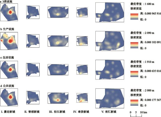
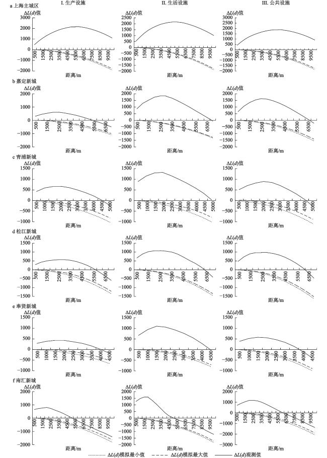
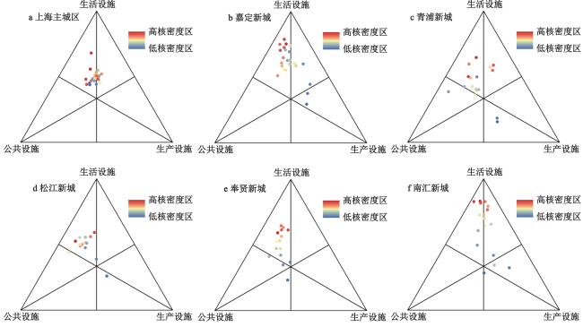
本文基于高德地图兴趣点(POI)数据,将其分为生活、生产、公共3类设施,采用核密度估计法、Ripley’s K函数等空间分析方法,并设计了一个反映设施类型结构在空间中演化的三角轨迹模型,以上海主城区为参考,基于不同类型设施的数量、分布和聚集程度,分析了上海五个新城的设施空间结构特征和分布规律,探讨了五个新城进一步建设的方向。研究发现:与上海主城区相比,五个新城的设施空间分布特征差异明显,发展历史较长的新城已经出现明显的单中心空间结构,而发展历史较短的新城表现为微弱的多中心结构;从设施高密度圈层到低密度圈层,主城区的设施类型结构变化较小,表现出内部“城市功能趋同”的特征,而五个新城则均表现出生活设施的占比逐步降低而公共设施和生产设施的占比升高的趋势,新城之间呈现“扩张结构趋同”的特征;新城的高密度圈层中,生活设施占比均高于主城区水平,表现出一定的“卧城”特征;低密度圈层中,尽管生产设施占比均高于高密度圈层,但不同类型设施聚集中心高度重合表明生产设施的聚集中心同样在新城的中心区,其外围城市功能薄弱,并没有出现完善的“专业功能中心”。因此,新城的进一步建设需强调设施的均衡协调发展,完善城市功能,避免出现“卧城”“空城”等现象。
沈思矣 , 顾高翔 , 张颖 , 刘杰 . 基于兴趣点的上海五个新城设施空间结构研究[J]. 地理科学, 2024 , 44(5) : 843 -852 . DOI: 10.13249/j.cnki.sgs.20220301
Since the Industrial Revolution, the agglomeration effect brought by the high specialization and division of labor of industry has continuously guided the concentration of elements and resources to cities. The rapid expansion has resulted in an increase in gathering costs, which has triggered a series of pressures on population, transportation, housing, environment, etc. These factors lead to the decline of the attractiveness of central cities and the transfer of urban development elements to multi centers. Among them, Shanghai has been exploring the breakthrough of polycentric development for a long time since the 1980s. The Shanghai Urban Master Plan (2017—2035) issued in 2017 proposed the new town development strategy of cultivating Shanghai’s Five New Towns into comprehensive nodes with radiating and driving capabilities in the Yangtze River Delta urban agglomeration. Therefore, based on the existing polycentric research and POI data, this paper studies the spatial structure characteristics of the Five New Towns in Shanghai during the polycentric process. Compared with previous studies on urban spatial structure, this paper focuses on the spatial distribution pattern of facilities at the micro level, at the same time, explores the combination characteristics of urban spatial structure between different circles, and innovates the research methods of urban spatial structure. Based on AutoNavi Maps point of interest (POI) data, this paper divides POI into 3 types of facilities: living, production and public. Kernel Density Estimation (KDE) and Ripley’s K Function are mainly used, and a triangular trajectory model is designed to reflect the structural evolution of facility types in space. Taking the main urban area of Shanghai as a reference, based on the number, distribution and aggregation degree of different types of facilities, this paper analyzes the spatial structure characteristics and distribution rules of facilities in the Five New Towns in Shanghai, and probes into the further construction direction of the five towns. The results show that compared with the urban area, the spatial distribution characteristics of facilities in the Five New Towns are significantly difference. The new towns with long development history have obvious single center spatial structure, while those with short development history show weak multi center structure. From the high-density circles to the low-density circles, the structure of facility types in the main urban area changes little, showing the characteristics of internal “convergence of urban functions”, while the Five New Towns show the trend of gradually decreasing the proportion of living facilities and increasing the proportion of public and production facilities. Between new towns, it shows the characteristics of “convergence of expansion structure”. In the high-density circles of the new towns, the proportion of living facilities is slightly higher than that of the main urban area, reflecting certain characteristics of “sleeping town”. In the low-density circles, although the proportion of production facilities is higher than that in the high-density circle, the concentration centers of 3 facilities are highly overlapped, indicating that the concentration center of production facilities is also in the central area of the new town, and its peripheral urban functions are weak, so there is no perfect “professional function center”. Therefore, the further construction of the Five New Towns needs to emphasize the balanced and coordinated development of facilities, improve urban functions and avoid the phenomena of “bedroom town” or “ghost town”.
表1 3类设施在空间中的关系类型Table 1 Relationship types of 3 types of facilities in space |
| 类型 | 关系 | 图示 |
| 注:“>”代表靠前设施在空间内占比更高;li、pi、ci分别为空间内生活设施、生产设施、公共设施的所占比例。 | ||
| Ⅰ | pi>ci>li | 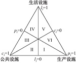 |
| Ⅱ | ci>pi>li | |
| Ⅲ | ci>li>pi | |
| Ⅳ | li>ci>pi | |
| Ⅴ | li>pi>ci | |
| Ⅵ | pi>li>ci | |
| [1] |
李健英. 空间经济聚集与分工外部性[J]. 广东社会科学, 2007(1): 29-34.
Li Jianying. Spatial economic agglomeration and externality of division of labor. Social Sciences in Guangdong, 2007(1): 29-34.
|
| [2] |
Krugman P. Increasing returns and Economic Geography[J]. Journal of Political Economy, 1991, 99(3): 483-499.
|
| [3] |
石忆邵. 从单中心城市到多中心城市——中国特大城市发展的空间组织模式[J]. 城市规划汇刊, 1999(3): 36-39+26-80.
Shi Yishao. From a single center city to a multi center city: The spatial organization model of the development of China’s mega cities. Urban Planning Forum, 1999(3): 36-39+26-80.
|
| [4] |
卢伟, 黄征学. 构建城市发展规划的八力分析模型研究[J]. 区域经济评论, 2021(1): 79-88.
Lu Wei, Huang Zhengxue. Research on eight forces analysis model of urban development planning. Regional Economic Review, 2021(1): 79-88.
|
| [5] |
Pawson E. Megalopolis: The urbanized northeastern seaboard of the United States[J]. Progress in Human Geography, 2008, 32(3): 441-444.
|
| [6] |
熊国平. 90年代以来中国城市形态演变研究[D]. 南京: 南京大学, 2005.
Xiong Guoping. Study on the morphology evolution of Chinese cities since 1990s. Nanjing: Nanjing University, 2005.
|
| [7] |
Long Y, Song Y, Chen L. Identifying subcenters with a nonparametric method and ubiquitous point-of-interest data: A case study of 284 Chinese cities[J]. Environment and Planning B Urban Analytics and City Science, 2021, 49(1): 58-75.
|
| [8] |
张丹, 孙铁山, 李国平. 中国首都圈区域空间结构特征——基于分行业就业人口分布的实证研究[J]. 地理研究, 2012, 31(5): 899-908.
Zhang Dan, Sun Tieshan, Li Guoping. Spatial structure of the capital metropolitan region in China: An empirical study of the employment distributions by sectors. Geographical Research, 2012, 31(5): 899-908.
|
| [9] |
王郁. 上海城市功能与人口郊区迁移的特征和影响分析[J]. 人文地理, 2007, 22(5): 34-37.
Wang Yu. Analysis of characteristics and influences of urban function and population redistribution in Shanghai. Human Geography, 2007, 22(5): 34-37.
|
| [10] |
叶昌东, 周春山. 近20年中国特大城市空间结构演变[J]. 城市发展研究, 2014, 21(3): 28-34.
Ye Changdong, Zhou Chunshan. Evolution of urban spatial structure in Chinese mega-cities in recent 20 years. Urban Studies, 2014, 21(3): 28-34.
|
| [11] |
毕秀晶, 汪明峰, 李健, 等. 上海大都市区软件产业空间集聚与郊区化[J]. 地理学报, 2011, 66(12): 1682-1694.
Bi Xiujing, Wang Mingfeng, Li Jian et al. Agglomeration and suburbanization: A study on the spatial distribution of software industry and its evolution in Metropolitan Shanghai. Acta Geographica Sinica, 2011, 66(12): 1682-1694.
|
| [12] |
马学新. 20世纪90年代上海产业布局的发展变化[J]. 当代中国史研究, 2009, 16(3): 92-99+127-128.
Ma Yuexin. Development and changes in industrial distribution in Shanghai in the 1990s. Contemporary China History Studies, 2009, 16(3): 92-99+127-128.
|
| [13] |
王春兰, 杨上广. 上海人口郊区化与新城发展动态分析[J]. 城市规划, 2015, 39(4): 65-70.
Wang Chunlan, Yang Shangguang. Dynamic analysis on population suburbanization and new town development of Shanghai City. City Planning Review, 2015, 39(4): 65-70.
|
| [14] |
上海市人民政府. 上海市城市总体规划(2017—2035年)[R/OL]. 2018. https://www.shanghai.gov.cn/newshanghai/xxgkfj/2035002.pdf.
Shanghai Municipal People’s Government. Shanghai master plan 2017—2035. Shanghai. 2018. https://www.shanghai.gov.cn/newshanghai/xxgkfj/2035002.pdf.
|
| [15] |
林华. 关于上海新城“产城融合”的研究——以青浦新城为例[J]. 上海城市规划, 2011(5): 30-36.
Lin Hua. Discussion on the “Urban and Industrial Integration” in the suburb of Shanghai—Taking Qingpu New City for example. Shanghai Urban Planning Review, 2011(5): 30-36.
|
| [16] |
肖池伟, 刘影, 李鹏, 等. 基于城市空间扩张与人口增长协调性的高铁新城研究[J]. 自然资源学报, 2016, 31(9): 1440-1451.
Xiao Chiwei, Liu Ying, Li Peng et al. Evaluation of the high-speed rail new town based on coordination of urban spatial expansion and population growth. Journal of Natural Resources, 2016, 31(9): 1440-1451.
|
| [17] |
查波, 季芳, 王春兰. 上海郊区新城人口集聚现状分析[J]. 统计科学与实践, 2012(10): 23-25.
Zha Bo, Ji Fang, Wang Chunlan. Analysis on the current situation of population agglomeration in new cities in Shanghai Suburbs. Statistical Theory and Practice, 2012(10): 23-25.
|
| [18] |
王颖, 孙斌栋, 乔森, 等. 中国特大城市的多中心空间战略——以上海市为例[J]. 城市规划学刊, 2012(2): 17-23.
Wang Ying, Sun Bindong, Qiao Sen et al. Polycentric spatial strategy of mega-cities in China—The case of Shanghai. Urban Planning Forum, 2012(2): 17-23.
|
| [19] |
宋伟轩, 徐旳, 王丽晔, 等. 近代南京城市社会空间结构: 基于1936年南京城市人口调查数据的分析[J]. 地理学报, 2011, 66(6): 771-784.
Song Weixuan, Xu Di, Wang Liye et al. Urban socio-spatial structure of Nanjing during the modern era: Analysis based on the data of urban population investigation in 1936. Acta Geographic Sinica, 2011, 66(6): 771-784.
|
| [20] |
徐旳, 朱喜钢. 近代南京城市社会空间结构变迁: 基于1929、1947年南京城市人口数据的分析[J]. 人文地理, 2008, 23(6): 17-22.
Xu Di, Zhu Xigang. The transformation of Nanjing urban social structure during the modern times. Human Geography, 2008, 23(6): 17-22.
|
| [21] |
王少剑, 莫惠敏, 吕慧妮, 等. 区位因素影响下高铁站区产业结构特征——基于POI数据的实证分析[J]. 地理学报, 2021, 76(8): 2016-2031.
Wang Shaojian, Mo Huimin, Lyu Huini et al. Industrial structure of high-speed railway station areas under the influence of location: Empirical evidences from POI data. Acta Geographica Sinica, 2021, 76(8): 2016-2031.
|
| [22] |
薛冰, 肖骁, 李京忠, 等. 基于兴趣点(POI)大数据的东北城市空间结构分析[J]. 地理科学, 2020, 40(5): 691-700.
Xue Bing, Xiao Xiao, Li Jingzhong et al. Analysis of spatial economic structure of northeast China cities based on points of interest (POI) big data. Scientia Geographica Sinica, 2020, 40(5): 691-700.
|
| [23] |
Lu C, Pang M, Zhang Y et al. Mapping urban spatial structure based on POI (Point of Interest) data: A case study of the central city of Lanzhou, China[J]. International Journal of Geo-Information, 2020, 9(2): 92
|
| [24] |
杜志强, 黄冬宁, 丁火平, 等. 融合POI数据的建成区人口数据空间化方法——以武汉市为例[J]. 地理信息世界, 2021, 28(1): 21-25.
Du Zhiqiang, Huang Dongning, Ding Huoping et al. Spatialization of population data in built-up Area merging with POI data: A case study over Wuhan City. Geomatics World, 2021, 28(1): 21-25.
|
| [25] |
许泽宁, 高晓路. 基于电子地图兴趣点的城市建成区边界识别方法[J]. 地理学报, 2016, 71(6): 928-939.
Xu Zening, Gao Xiaolu. A novel method for identifying the boundary of urban built-up areas with POI data. Acta Geographica Sinica, 2016, 71(6): 928-939.
|
| [26] |
Deng Y, Liu J, Liu Y et al. Detecting urban polycentric structure from POI Data[J/OL]. International Journal of Geo-Information, 2019, 8(6): 283.https://doi.org/10.3390/ijgi8060283.
|
| [27] |
舒天衡, 任一田, 申立银, 等. 大型城市消费活力的空间异质性及其驱动因素研究——以成都市为例[J]. 城市发展研究, 2020, 27(1): 16-21.
Shu Tianheng, Ren Yitian, Shen Liyin et al. Study on spatial heterogeneity of consumption vibrancy and its driving factors in large city: A case of Chengdu City. Urban Development Studies, 2020, 27(1): 16-21.
|
| [28] |
Yang X, Ye T, Zhao N et al. Population mapping with multisensor remote sensing images and point-of-interest data[J/OL]. Remote Sensing, 2019, 11(5): 574. https://doi.org/10.3390/rs11050574.
|
| [29] |
王德, 王灿, 谢栋灿, 等. 基于手机信令数据的上海市不同等级商业中心商圈的比较: 以南京东路、五角场、鞍山路为例[J]. 城市规划学刊, 2015, (3): 50-60.
Wang De, Wang Can, Xie Dongcan et al. Comparison of retail trade areas of retail centers with different hierarchical levels: A case study of East Nanjing Road, Wujiaochang, Anshan Road in Shanghai. Urban Planning Forum, 2015, (3): 50-60.
|
| [30] |
上海市新城规划建设推进协调领导小组办公室. 上海市新城规划建设导则[R/OL]. 上海, 2021. https://www.shanghai.gov.cn.
Shanghai New Town Planning and Construction Promotion Coordination Leading Group Office. Shanghai new town planning and implementing guideline. Shanghai, 2021. https://www.shanghai.gov.cn.
|
| [31] |
陈蔚珊, 柳林, 梁育填. 基于POI数据的广州零售商业中心热点识别与业态集聚特征分析[J]. 地理研究, 2016, 35(4): 703-716.
Chen Weishan, Liu Lin, Liang Yutian. Retail center recognition and spatial aggregating feature analysis of retail formats in Guangzhou based on POI data. Geographical Research, 2016, 35(4): 703-716.
|
| [32] |
Okabe A, Yamada I. The K-function method on a network and its computational implementation[J]. Geographical Analysis, 2001, 33(3): 271-290.
|
| [33] |
顾维铭. 郊区城市化进程中的政府主导型新城建设模式研究[D]. 上海: 复旦大学, 2010.
Gu Weiming. Research on the dominant mode of government in construction of new city in the process of suburb urbanization. Shanghai: Fudan University, 2010.
|
| [34] |
沈爱华. 高新技术产业开发区选址与总体布局研究[D]. 西安: 西安建筑科技大学, 2003.
Shen Aihua. Study on location option and overall layout of the new-high technology industrial development zone. Xi’an: Xi’an University of Architecture and Technology, 2003.
|
| [35] |
张贝贝, 刘云刚. “卧城”的困境、转型与出路: 日本多摩新城的案例研究[J]. 国际城市规划, 2017, 32(1): 130-137.
Zhang Beibei, Liu Yungan. Commuter town’s problems, transition and future: A case study of Tama New Town, Japan. Urban Planning International, 2017, 32(1): 130-137.
|
| [36] |
上海市人民政府. 上海市人民政府印发《关于本市“十四五”加快推进新城规划建设工作的实施意见》的通知 [EB/OL]. 2021-03-02. https://www.shanghai.gov.cn/nw12344/20210302/6c8561a91a67478899a5eb51aa612d78.html.
Shanghai Municipal People’s Government. Notice on the implementation of accelerating the planning and construction of new towns in the 14th five year plan. 2021-03-02. https://www.shanghai.gov.cn/nw12344/20210302/6c8561a91a67478899a5eb51aa612d78.html.
|
/
| 〈 |
|
〉 |