
基于PLUS模拟未来土地利用变化的可持续发展评估——以江西省为例
|
杨子韬(2000—),男,湖南岳阳人,硕士研究生,主要从事景观生态与土地利用评估研究。E-mail: yangzitao0414@igsnrr.ac.cn |
收稿日期: 2023-06-17
修回日期: 2023-09-22
网络出版日期: 2024-11-01
基金资助
中国科学院基础前沿科学研究计划从0到1原始创新项目(ZDBS-LY-DQC023)
版权
Sustainability assessment based on PLUS simulation of future land use change: A case study of Jiangxi Province
Received date: 2023-06-17
Revised date: 2023-09-22
Online published: 2024-11-01
Supported by
The Chinese Academy of Sciences’ Basic Frontier Scientific Research Program Goes from 0 to 1 Original Innovation Project(ZDBS-LY-DQC023)
Copyright
以江西省2010年和2020年土地利用现状为基期数据,并结合江西省自然资源特点与土地利用政策,利用PLUS模型对该省2030年土地利用进行3种未来情景模拟(正常发展情景、生态保护情景和耕地保护情景);通过模拟分析发掘其内涵生长规律和土地转变机制;并基于可持续发展理念对未来的3种发展情景结果进行评估,结果表明:① 2010—2020年江西省土地利用主要表现为耕地、林地面积的持续减少,灌木和建设用地面积的稳定上升;土地转型过程中耕、林、灌木地转变突出,耕地和林地是建设用地的扩张之源,林地与耕地之间存在置换;② 在未来(2030年)3种情景的模拟适宜性评估中,正常发展情景的面积变化较2010—2020年基本一致,其社会效益和经济效益最高,情景模拟适宜性指数(SSI)值最大,可持续发展潜力最好;生态保护情景下灌木地、水域、湿地面积略有增加,耕地锐减,对比其他两种情景,其生态效益最好,情景适宜性良好;耕地保护情景下的耕地资源回补,林地面积大幅减少,建设用地和灌木面积增加,其经济效益最低,情景适宜性一般。多情景模拟反映了江西省不同侧重点的发展需求,为管理者在未来国土空间规划和开发上提供参考依据。
杨子韬 , 田莉 . 基于PLUS模拟未来土地利用变化的可持续发展评估——以江西省为例[J]. 地理科学, 2024 , 44(10) : 1826 -1836 . DOI: 10.13249/j.cnki.sgs.20230581
This paper takes the current land use situation in Jiangxi Province in 2010 and 2020 as the base period data, and combines the characteristics of natural resources and land use policies in Jiangxi Province, then it uses the PLUS model to simulate three future scenarios of land use in the province in 2030 (the normal development scenario, the ecological protection scenario, and the arable land protection scenario), discovering the connotation of the growth law and the mechanism of land transformation through the simulation analysis and evaluating the results of the three future development scenarios based on the concept of sustainable development. The results of the three future development scenarios were evaluated based on the concept of sustainable development. The results show that: 1) From 2010 to 2020, the main trends in land use in Jiangxi Province are a continuous decrease in farmland and forest area, and a stable increase in shrub and construction land area. During the land transformation process, the conversion between farmland, forest, and shrub land is prominent, with farmland and forest serving as the main sources of construction land expansion, and there is a substitution relationship between forest and farmland. 2) In the suitability assessment of the three future scenarios (2030), the normal development scenario shows consistent changes in area compared to the 2010—2020 period. It has the highest social and economic benefits, the largest suitability simulation index (SSI), and the best potential for sustainable development. Under the ecological protection scenario, the areas of shrub land, water bodies, and wetlands slightly increase, while farmland decreases significantly. Compared to the other two scenarios, it has the best ecological benefits and good suitability. Under the farmland protection scenario, farmland resources are replenished, forest area decreases sharply, and the areas of construction land and shrub land increase. It has the lowest economic benefits and moderate suitability. The multi-scenario simulations reflect the different development needs of Jiangxi Province, providing reference for managers in future land spatial planning and development.
Key words: land use; PLUS model; scenario simulation; Jiangxi Province; sustainable development
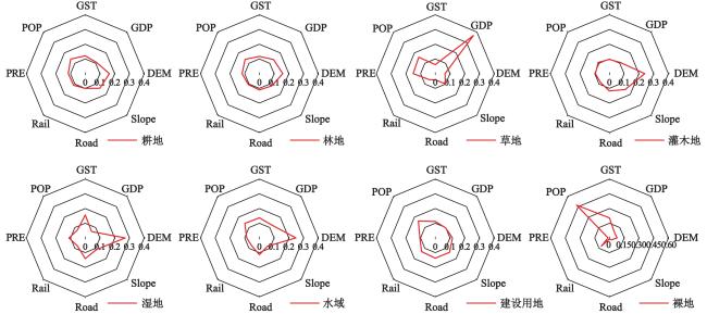
表1 驱动因素数据来源信息Table 1 Driver data source information |
| 序号 | 驱动因素 | 年份(分辨率) | 代号 | 数据来源 |
| 1 | 年均温 | 2020(1 km) | GST | 中国科学院资源环境数据中心① |
| 2 | 年降水 | 2020(1 km) | PRE | 中国科学院资源环境数据中心 |
| 3 | 高程数据 | 2009(30 m) | DEM | 地理空间数据云② |
| 4 | 坡度 | 2009(30 m) | Slope | ArcGIS 坡度分析 |
| 5 | 地区生产总值 | 2019(1 km) | GDP | 中国科学院资源环境数据中心 |
| 6 | 人口密度 | 2019(1 km) | POP | 中科院资源环境数据中心 |
| 7 | 距道路距离 | 2017(30 m) | Road | 路网数据来源于全国地理信息资源目录服务系统③, 距离栅格数据经ArcGIS欧氏距离分析得到 |
| 8 | 距铁路距离 | 2017(30 m) | Rail | 路网数据来源于全国地理信息资源目录服务系统, 距离栅格数据经ArcGIS欧氏距离分析得到 |
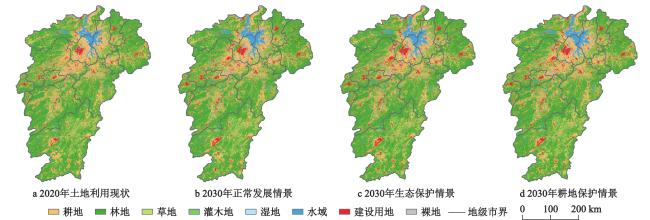
表2 3种模拟发展情景Table 2 Three simulated development scenarios |
| 模拟发展情景 | 基本要求 |
| 正常发展情景 | 假设未来土地利用政策不变,土地利用变化情况与2010—2020年变化情况保持一致,各地类被转移概率不作调整 |
| 生态保护情景 | 在江西省“十四五”生态环境保护规划中表示,要坚决划定和严守生态保护红线,保障生态安全和国土安全。为实现生态保护的目的,设定减少林地、草地、灌木地、湿地和水域的被转移发生概率(林地和湿地减少30%,草地、灌木地和水域减少20%),其他地类概率不做变化 |
| 耕地保护情景 | 据江西省人民政府发布的《关于加强耕地保护的意见》,文件提出要坚守(26 697.27 km2)耕地保护红线。因此本文在该情景下,通过减少耕地被转移发生概率(40%),禁止耕地转变为建设用地、裸地和草地,其他地类的概率不作变化,来控制耕地转变为其他地类,以实现耕地资源的补充 |
表3 区域模拟情景适宜性评价指标体系Table 3 Sustainable development indicator system based on scenario simulation |
| 系统 | 子系统 | 指标 | 解释 | 属性 | 权重/% |
| 情景模拟适宜 性指数(SSI) | 社会效益(Sl) | 人均耕地面积(Pc) | 当期耕地面积/当期人口数量 | 正 | |
| 城市化效率(Ue) | 当期建设用地面积/当期城镇化率 | 正 | |||
| 经济效益(Ey) | 建设经济效率(Ce) | 研究期新增建设用地面积/研究期新增GDP | 正 | ||
| 生态经济效率(Ee) | 当期生态系统服务价值/当期地区生产总值 | 正 | |||
| 生态效益(Eg) | 生态系统服务价值(ESV) | 基于陆地生态系统价值当量表计算 | 正 | ||
| 生态承载力(ECC) | 基于均衡因子和产量因子计算 | 正 | |||
| 生态安全指数(ESI) | 基于景观干扰指数和景观脆弱指数计算 | 正 |
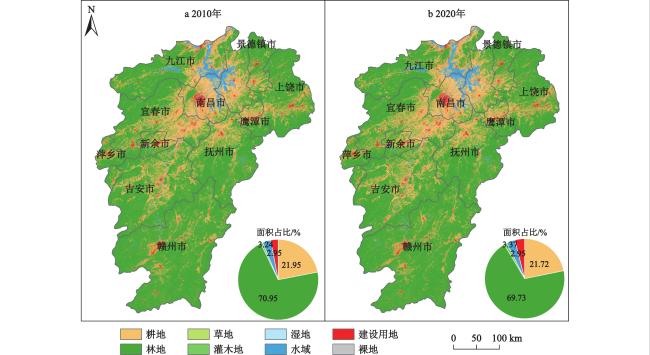
表4 2010—2020年江西省土地利用变化数量指标Table 4 Quantity index of land use change in Jiangxi Province from 2010 to 2020 |
| 土地利用类型 | 面积变化/km2 | 面积变化幅度/% | 年均变化率/% | 动态度/‰ |
| 耕地 | −424.110 | −0.225 | −0.102 | 2.093 |
| 林地 | − | −1.218 | −0.172 | 2.062 |
| 草地 | 7.028 | 0.004 | 2.608 | 0.004 |
| 灌木地 | 568.694 | 0.301 | 3.859 | 0.351 |
| 湿地 | 61.451 | 0.033 | 2.913 | 0.033 |
| 水域 | 238.029 | 0.126 | 0.390 | 0.277 |
| 建设用地 | 0.979 | 3.314 | 0.979 | |
| 裸地 | 0.293 | 0.000 | 5.102 | 0.000 |
表5 2020—2030年江西省土地利用面积及面积变化Table 5 Three situations of land use area and area changes in Jiangxi Province from 2020 to 2030 |
| 土地利 用类型 | 2020年实际土地 利用面积/km2 | 2030年情景模拟土地利用面积/km2 | 2020—2030年土地面积变化/km2 | |||||
| 正常发展情景 | 生态保护情景 | 耕地保护情景 | 正常发展情景 | 生态保护情景 | 耕地保护情景 | |||
| 耕地 | −426.60 | − | 438.84 | |||||
| 林地 | − | −545.63 | − | |||||
| 草地 | 33.98 | 40.97 | 32.73 | 40.07 | 7.00 | −1.25 | 6.09 | |
| 灌木地 | 540.23 | 301.07 | 537.33 | |||||
| 湿地 | 272.40 | 334.42 | 334.50 | 291.67 | 62.03 | 62.10 | 19.28 | |
| 水域 | 228.15 | 161.09 | −102.83 | |||||
| 建设用地 | 626.49 | |||||||
| 裸地 | 0.87 | 0.76 | 0.29 | 0.76 | −0.11 | −0.58 | −0.11 | |
表6 江西2020年现状及2030年3种模拟情景的指标计算结果Table 6 Current situation of Jiangxi in 2020 and index calculation results of three simulation scenarios in 2030 |
| 指标 | 2020年现状 | 2030年模拟 | ||
| 正常发展情景 | 生态保护情景 | 耕地保护情景 | ||
| 注:数据经过归一化处理。 | ||||
| 人均耕地面积(Pc) | ||||
| 城市化效率(Ue) | ||||
| 建设经济效率(Ce) | ||||
| 生态经济效率(Ee) | ||||
| 生态系统服务价值(ESV) | ||||
| 生态承载力(ECC) | ||||
| 生态安全指数(ESI) | ||||
| 社会效益(Sl) | ||||
| 经济效益(Ey) | ||||
| 生态效益(Eg) | ||||
| 情景模拟适宜性指数(SSI) | ||||
| [1] |
Jonathan A Foley, Ruth Defries, Gregory P Asner, Carol. Global consequences of land use[J]. Science, 2005, 309(5734): 570-574.
|
| [2] |
Lawler J J, Lewis D J, Nelson E et al. Projected land-use change impacts on ecosystem services in the United States[J]. Proceedings of the National Academy of Sciences, 2014, 111(20): 7492-7497.
|
| [3] |
Wulder M A, White J C, Goward S N et al. Landsat continuity: Issues and opportunities for land cover monitoring[J]. Remote Sensing of Environment, 2008, 112(3): 955-969.
|
| [4] |
Mooney H A, Duraiappah A, Larigauderie A. Evolution of natural and social science interactions in global change research programs[J]. Proceedings of the National Academy of Sciences, 2013, 110(supplement_1): 3665-3672.
|
| [5] |
Chang X, Zhang F, Cong K et al. Scenario simulation of land use and land cover change in mining area[J]. Scientific Reports, 2021, 11(1): 1-12.
|
| [6] |
Higueras A M.Teoría y método de la Geografía [M]//Aragon Region, Spain: Zaragoza University 621 Press, 2003.
|
| [7] |
Lambin E F, Turner B L, Geist H J et al. The causes of landuse and land-cover change: Moving beyond the myths[J]. Global Environmental Change, 2001, 11(4): 261-269.
|
| [8] |
Long H, Zhang Y, Ma L et al. Land use transitions: Progress, challenges and prospects[J]. Land, 2021, 10(9): 903.
|
| [9] |
李秀彬. 全球环境变化研究的核心领域──土地利用/土地覆被变化的国际研究动向[J]. 地理学报, 1996 6 553-558.
Li Xiubin. A review of the International research on land use / land cover change. Acta Geographic Sinica, 1996 6 553-558.
|
| [10] |
苏迎庆, 刘庚, 赵景波, 等. 基于 FLUS 模型的汾河流域生态空间多情景模拟预测[J]. 干旱区研究, 2021, 38(4): 1152-1161.
Su Yingqing, Liu Geng, Zhao Jingbo et al. Multi-scenario simulation prediction of ecological space in the Fenhe River Basin using the FLUS model. Arid Zone Reaserch, 2021, 38(4): 1152-1161.
|
| [11] |
龙花楼, 戈大专, 王介勇. 土地利用转型与乡村转型发展耦合研究进展及展望[J]. 地理学报, 2019, 74(12): 2547-2559.
Long Hualou, Ge Dazhuan, Wang Jieyong. Progress and prospects of the coupling research on land use transitions and rural transformation development. Acta Geographic Sinica, 2019,74 (12): 2547-2559.
|
| [12] |
吴欣昕, 刘小平, 梁迅, 等. FLUS-UGB 多情景模拟的珠江三角洲城市增长边界划定[J]. 地球信息科学学报, 2018, 20(4): 532-542.
Wu Xinxin, Liu Xiaoping, Liang Xun et al. Multi-scenarios simulation of urban srowth boundaries in Pearl River Delta Based on FLUS-UGB. Journal of the Geo-information Science, 2018, 20(4): 532-542.
|
| [13] |
邓华, 邵景安, 王金亮, 等. 多因素耦合下三峡库区土地利用未来情景模拟[J]. 地理学报, 2016, 71(11): 1979-1997.
Deng Hua, Shao Jingbo, Wang Jinliang et al. Land use driving forces and its future scenario simulation in the Three Gorges Reservoir Area using CLUE-S model. Acta Geographic Sinica, 2016, 71(11): 1979-1997.
|
| [14] |
Virtriana R, Sumarto I, Deliar A et al. Model of land cover change prediction in West Java using cellular automata-Markov chain (CA-MC) [C]//Kuala Lumpur, Malaysia : National Physics Conference 2014 (Perfik 2014), 2015: 060008.
|
| [15] |
Talukdar S, Singha P, Mahato S et al. Land-use land-cover classification by machine learning classifiers for satellite observations—A review[J]. Remote Sensing, 2020, 12(7): 1135.
|
| [16] |
王秀兰, 包玉海. 土地利用动态变化研究方法探讨[J]. 地理科学进展, 1999 1 83-89.
Wang Xiulan, Bao Yuhai. Research methods on the dynamic change of land use. Progress in Geographical Science, 1999 1 83-89.
|
| [17] |
Verburg P H, Van Berkel D B, Van Doorn A M et al. Trajectories of land use change in Europe: A model-based exploration of rural futures[J]. Landscape Ecology, 2010, 25(2): 217-232.
|
| [18] |
Çağlıyan A, Dağlı D. Monitoring land use land cover changes and modelling of urban growth using a future land use simulation model (FLUS) in Diyarbakir, Turkey[J]. Sustainability, 2022, 14(15): 9180.
|
| [19] |
Liang X, Guan Q, Clarke K C et al. Understanding the drivers of sustainable land expansion using a patch-generating land use simulation (PLUS) model: A case study in Wuhan, China[J]. Computers, Environment and Urban Systems, 2021, 85: 101569.
|
| [20] |
Liu L Y, Zhang X, Chen X D et al. GLC_FCS30-2010: Global land cover with fine classification system at 30 m in 2010[DS/OL].https://data.casearth.cn/dataset/6123651428a58f70c2a51e47.
|
| [21] |
Liu L Y, Zhang X, Chen X D et al. GLC_FCS30-2020: Global land cover with fine classification system at 30 m in 2020[DS/OL].https://data.casearth.cn/dataset/6123651428a58f70c2a51e49.
|
| [22] |
江西省统计局, 国家统计局江西调查总队.江西统计年鉴[M]. 北京: 中国统计出版社, 2023.
Jiangxi Provincial Bureau of Statistics, Surver Office of the National Bureau of Statistice in Jiangxi. Jiangxi statistical yearbook. Beijign: China Statistics Press, 2023.
|
| [23] |
国家发展和改革委员会价格司. 全国农产品成本收益资料汇编[M]. 北京:中国统计出版社, 2022.
Price Department of National Development and Reform Commission. Compilation of national agricultural product cost and benefit information. Beijing: China Statistics Press, 2022.
|
| [24] |
朱会义, 李秀彬, 何书金, 等. 环渤海地区土地利用的时空变化分析[J]. 地理学报, 2001 3 253-260.
Zhu Huiyi, Li Xiubin, He Shujin et al. Spatio-temporal change of land use in Bohai Rim. Journal of Geography Science, 2001 3 253-260.
|
| [25] |
刘纪远, 宁佳, 匡文慧, 等. 2010—2015年中国土地利用变化的时空格局与新特征[J]. 地理学报, 2018, 73(5): 789-802.
Liu Jiyuan, Ning Jia, Kuang Wenhui et al. Spatio-temporal patterns and characteristics of land-use change in China during 2010—2015. Acta Geographic Sinica, 2018, 73(5): 789-802.
|
| [26] |
Alvan R. Feinstein , Domenic V Cicchetti. High agreement but low Kappa: I. The problems of two paradoxes[J]. Journal of Clinical Epidemiology, 1990, 43(6): 543-549.
|
| [27] |
High agreement but low kappa: II. Resolving the paradoxes[J]. Journal of Clinical Epidemiology, 1990, 43(6): 551-558.
|
| [28] |
Pontius R G, Boersma W, Castella J C et al. Comparing the input, output and validation maps for several models of land change[J]. The Annals of Regional Science, 2008, 42(1): 11-37.
|
| [29] |
Podvezko V. Application of AHP Ttechnique[J]. Journal of Business Economics and Management, 2009, 10(2): 181-189.
|
| [30] |
谢高地, 张彩霞, 张雷明, 等. 基于单位面积价值当量因子的生态系统服务价值化方法改进[J]. 自然资源学报, 2015, 30(8): 1243-1254.
Xie Gaodi, Zhang Caixie, Zhang Leiming et al. Improvement of the evaluation method for ecosystem service value based on per unit area. Journal of Natural Resources, 2015, 30(8): 1243-1254.
|
| [31] |
肖玉, 谢高地, 安凯, 等. 基于功能性状的生态系统服务研究框架[J]. 植物生态学报, 2012, 36(4): 353-362.
Xiao Yu, Xie Gaodi, An Kai et al. A research framework of ecosystem services based on functional traits. Chinese Journal of Plant Ecology, 2012, 36(4): 353-362.
|
| [32] |
封志明, 杨艳昭, 闫慧敏, 等. 百年来的资源环境承载力研究: 从理论到实践[J]. 资源科学, 2017, 39(3): 379-395.
Feng Zhiming, Yang Yznzhao, Yan Huimin et al. A review of resources and environment carrying capacity research since the 20th Century: From theory to practice. Resources Science, 2017, 39(3): 379-395.
|
| [33] |
郭慧, 董士伟, 吴迪, 等. 基于生态系统服务价值的生态足迹模型均衡因子及产量因子测算[J]. 生态学报, 2020, 40(4): 1405-1412.
Guo Hui, Dong Shiwei, Wu Di et al. Calculation and analysis of equivalence factor and yield factor of ecological footprint based on ecosystem services value. Acta Ecologica Sinica, 2020, 40(4): 1405-1412.
|
| [34] |
童亿勤. 基于本地生态足迹模型的浙江省可持续发展评价[J]. 长江流域资源与环境, 2009, 18(10): 896-902.
Tong Yiqin. Evaluation of sustainable development in Zhejiang Province based on local ecological footprint modeling. Resources and Environment in the Yangtze Basin, 2009, 18(10): 896-902.
|
| [35] |
陈鹏, 潘晓玲. 干旱区内陆流域区域景观生态风险分析——以阜康三工河流域为例[J]. 生态学杂志, 2003 4 116-120.
Chen Peng, Pan Xiaoling. Ecological risk analysis of regional land scape in inland river watershed of arid area—A case study of Sangong River Basin in Fukang. Chinese Journal of Ecology, 2003 4 116-120.
|
| [36] |
谢花林. 基于景观结构和空间统计学的区域生态风险分析[J]. 生态学报, 2008 10 5020-5026.
Xie Hualin. Regional eco-risk analysis of based on landscape structure and spatial statistics. Acta Ecologica Sinica, 2008 10 5020-5026.
|
| [37] |
Genugten B B V D. The asymptotic behaviour of the estimated generalized least squares method in the linear regression model[J]. Statistica Neerlandica, 1983, 37(3): 127-141.
|
| [38] |
胡西武, 廉恩慧, 才仁卓玛. 三江源国家公园土地利用结构与空间布局优化研究[J]. 青海民族研究, 2022, 33(2): 190-199.
Hu Xiwu, Lian Enhui, Cairenzhuoma. Optimization of land use structure and spatial layout of Sanjiangyuan National Park. Qinghai Journal of Ethnology, 2022, 33(2): 190-199.
|
| [39] |
张学儒, 周杰, 李梦梅. 基于土地利用格局重建的区域生境质量时空变化分析[J]. 地理学报, 2020, 75(1): 160-178.
Zhang Xueru, Zhou Jie, Li Mengmei. Analysis on spatial and temporal changes of regional habitat quality based on the spatial pattern reconstruction of land use. Acta Geogrophica Sinica, 2020, 75(1): 160-178.
|
| [40] |
袁雪松, 周俊, 胡蓓蓓, 等. 基于 FLUS 模型粤港澳大湾区“三生空间”多情景模拟预测[J]. 地理科学, 2023, 43(3): 564-574.
Yuan Xuesong, Zhou Jun, Hu Beibei et al. Multi-scenario simulation and prediction of ecological-productive-living spaces in Guangdong-Hong Kong-Macao Greater Bay Area based on FLUS model. Scientia Geographica Sinica, 2023, 43(3): 564-574.
|
| [41] |
邓辉, 何政伟, 陈晔, 等. 四川盆地大都市边缘区土地利用时空格局模拟——以资阳市雁江区为例[J]. 地理科学, 2013, 33(12): 1524-1530.
Deng Hui, He Zhengwei, Chen Ye et al. The land use spatio-temporal pattern simulation in metropolitan fringe of the Sichuan Basin: A case study in Yanjian District, Ziyang City, Sichuan. Scientia Geographica Sinica, 2013, 33(12): 1524-1530.
|
| [42] |
朱文博, 张静静, 崔耀平, 等. 基于土地利用变化情景的生态系统碳储量评估——以太行山淇河流域为例[J]. 地理学报, 2019, 74(3): 446-459.
Zhu Wenbo, Zhang Jingjing, Cui Yaoping et al. Assessment of territorial ecosystem carbon storage based on land use change scenario: A case study in Qihe River Basin. Acta Geogrophica Sinica, 2019, 74(3): 446-459.
|
| [43] |
何春阳, 史培军, 李景刚, 等. 中国北方未来土地利用变化情景模拟[J]. 地理学报, 2004, 59(4): 599-607.
He Chunyang, Shi Peijun, Li Jinggang et al. Scenarios simulation and use change in the northern China by system dynamic model. Acta Geogrophica Sinica, 2004, 59(4): 599-607.
|
| [44] |
何艳虎, 龚镇杰, 林凯荣. 基于地理大数据和多源信息融合的区域未来人口精细化空间分布模拟研究——以珠江三角洲为例[J]. 地理科学, 2022, 42(3): 426-435.
He Yanhu, Gong Zhenjie, Lin Kairong. Simulation of fine spatial distribution of regional future population based on geographical big data and multisource fused method: A case of the Pearl River Delta. Scientia Geographica Sinica, 2022, 42(3): 426-435.
|
| [45] |
Zhou M, Ma Y, Tu J et al. SDG-oriented multi-scenario sustainable land-use simulation under the background of urban expansion[J]. Environmental Science and Pollution Research, 2022, 29(48): 72797-72818.
|
/
| 〈 |
|
〉 |