
试论中国耕地增减的地理分界线:40°N
|
谈明洪(1970—),男,江苏涟水人,研究员,博导,主要从事土地利用变化研究。E-mail: tanmh@igsnrr.ac.cn |
收稿日期: 2023-11-02
修回日期: 2024-03-24
网络出版日期: 2025-04-29
版权
Analysis of geographical dividing line of cropland changes in China: 40°N
Received date: 2023-11-02
Revised date: 2024-03-24
Online published: 2025-04-29
Copyright
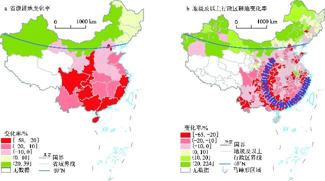
随着社会经济的迅猛发展,中国耕地变化呈现出显著的区域分异特征,研究此分异特征对把握未来耕地变化趋势、因地制宜制定耕地保护政策和提高政策的实施效果都非常重要。利用遥感影像解译的土地利用图、全国国土调查成果等多种数据源,分析了1990—2020年中国耕地的空间格局变化,并提出中国耕地增减的地理分界线:40°N线,即古代的农牧业分界线。在过去30 a,耕地变化在此线南北两侧呈现出截然相反的趋势:北侧(古代牧区)呈快速增长的态势,南侧则相反,呈减少趋势。耕地减少最快的地区主要分布在由东南沿海和(中国地势)二级阶梯的南段共同构成的“马蹄形”区域。最后,系统分析了引起40°N线南北两侧耕地变化的驱动因素,并提出相应的政策建议。

谈明洪 , 闫紫艳 , 李秀彬 , 徐晓凡 , 黄振宇 . 试论中国耕地增减的地理分界线:40°N[J]. 地理科学, 2025 , 45(5) : 941 -949 . DOI: 10.13249/j.cnki.sgs.20231034
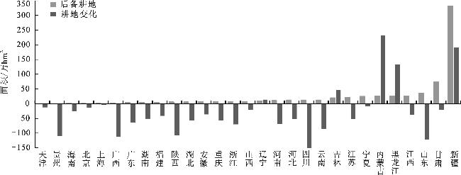
Changes in cropland are affected or restricted by natural resource endowment, economy, society, technology and other factors, and are a comprehensive index reflecting the change of human-land relationship. With the rapid development of society and economy, the changes of cropland in China present significant regional differentiation characteristics. Studying the characteristics is very important for grasping the future development trend of cropland, formulating cropland protection policies according to local conditions, and improving the implementation effect of policies. Based on land use maps interpreted by remote sensing images and national land survey data, this paper analyzes the spatial changes of cropland in China in the past 30 years, and proposes the geographical dividing line of cropland increase and decrease in China: 40°N. In the north and south sides of this line, the changes of cropland showed an opposite trend. According to the national Land survey, from 2009 to 2019, cropland in the south decreased by 14.5% and increased by14.0% in the north. And the proportion of cropland in the north of the total cropland area in the whole country increased from 31.5% in 2009 to 38.1% in 2019, which significantly increased its importance in China’s agricultural production. The fastest reduction of cropland in the south is mainly distributed in the southeast coast and the southern section of the second stage, which is a “horseshoe” area. Finally, this paper systematically analyzes the causes of cropland change on both sides of the north and south, and puts forward the corresponding policy suggestions on cropland use. In arid and semi-arid areas of China with better irrigation conditions, drip irrigation technology should be widely adopted, and water-fertilizer integration should be implemented to tap the potential of existing cropland. In the “horseshoe” area, due to the occupation of construction land and the adjustment of agricultural structure, the speed of the reduction of cultivated land is fast, and the policy aim of balancing the total cropland in this area has been difficult to achieve, so the policy of protecting cropland should be adjusted correspondingly. In the south of the 40°N line, especially in the north China Plain and inside the “horseshoe” area, priority should be given to protecting high-quality, flat farmland suitable for large-scale operations for grain production, strictly controlling the expansion and occupation of construction land and non-grain agricultural land, and preventing the fragmentation of cropland.
| [1] |
Fukase E, Martin W. Who will feed China in the 21st century?Income growth and food demand and supply in China. Journal of Agricultural Economics, 2016, 67(1): 3-23
|
| [2] |
Brown L R. Who will feed China?[M]. New York: W. W. Norton & Company, 1995.
|
| [3] |
李丹, 周嘉, 战大庆. 黑龙江省耕地时空变化及驱动因素分析[J]. 地理科学, 2021, 41(7): 1266-1275
Li Dan, Zhou Jia, Zhan Daqing. Spatial and temporal changes and driving factors of cultivated land in Heilongjiang Province. Scientia Geographica Sinica, 2021, 41(7): 1266-1275
|
| [4] |
王俊枝, 薛志忠, 张弛, 等. 内蒙古河套平原耕地盐碱化时空演变及其对产能的影响[J]. 地理科学, 2019, 39(5): 827-835
Wang Junzhi, Xue Zhizhong, Zhang Chi et al. Spatio-temporal evolution of saline-alkali cultivated land and its impact on productivity in Hetao Plain of Inner Mongolia. Scientia Geographica Sinica, 2019, 39(5): 827-835
|
| [5] |
魏慧, 吕昌河, 尹旭. 青藏高原耕地的空间分异及其影响因素[J]. 地理科学, 2023, 43(3): 379-387
Wei Hui, Lyu Changhe, Yin Xu. Spatial differentiation of farmland and influencing factors on the Qinghai-Tibet Plateau. Scientia Geographica Sinica, 2023, 43(3): 379-387
|
| [6] |
安悦, 谭雪兰, 李印齐, 等. 洞庭湖地区耕地功能时空演变特征及影响因素研究[J]. 地理科学, 2022, 42(7): 1272-1282
An Yue, Tan Xuelan, Li Yinqi et al. Spatio-temporal evolution characteristics and influencing factors of cultivated land functions in the Dongting Lake aera. Scientia Geographica Sinica, 2022, 42(7): 1272-1282
|
| [7] |
黄贤金, 濮励杰, 尚贵华. 耕地总量动态平衡政策存在问题及改革建议[J]. 中国土地科学, 2001, 15(4): 2-6
Huang Xianjin, Pu Lijie, Shang Guihua. Operational analysis and reform to policy of dynamic overall cultivated land balance in China. China Land Science, 2001, 15(4): 2-6
|
| [8] |
郑海霞, 封志明. 中国耕地总量动态平衡的数量和质量分析[J]. 资源科学, 2003, 25(5): 33-39
Zheng Haixia, Feng Zhiming. The quantity and quality analysis on dynamic equilibrium of the total cultivated land in China. Resources Science, 2003, 25(5): 33-39
|
| [9] |
Ning J, Liu J Y, Kuang W H et al. Spatiotemporal patterns and characteristics of land-use change in China during 2010—2015[J]. Journal of Geographical Sciences, 2018, 28(5): 547-562
|
| [10] |
王鸣雷, 史文娇. 中国北方新增耕地的时空变化及驱动因素分区[J]. 中国农业科学, 2020, 53(12): 2435-2449
Wang Minglei, Shi Wenjiao. Spatial-temporal changes of newly cultivated land in northern China and its zoning based on driving factors. Scientia Agricultura Sinica, 2020, 53(12): 2435-2449
|
| [11] |
孙立, 朱西存, 王介勇, 等. 中国北方十二省份耕地变化与粮食增产时空耦合关系研究[J]. 地域研究与开发, 2022, 41(5): 139-145
Sun Li, Zhu Xicun, Wang Jieyong et al. Study of spatial-temporal coupling relationship between cultivated land change and grain output increase in 12 provinces of northern China. Areal Research and Development, 2022, 41(5): 139-145
|
| [12] |
刘彦随, 张紫雯, 王介勇. 中国农业地域分异与现代农业区划方案[J]. 地理学报, 2018, 73(2): 203-218
Liu Yansui, Zhang Ziwen, Wang Jieyong. Regional differentiation and comprehensive regionalization scheme of modern agriculture in China. Acta Geographica Sinica, 2018, 73(2): 203-218
|
| [13] |
刘纪远, 张增祥, 庄大方, 等. 20世纪90年代中国土地利用变化时空特征及其成因分析[J]. 地理研究, 2003, 22(1): 1-12
Liu Jiyuan, Zhang Zengxiang, Zhuang Dafang et al. A study on the spatial-temporal dynamic changes of land-use and driving forces analyses of China in the 1990s. Geographical Research, 2003, 22(1): 1-12
|
| [14] |
刘纪远, 宁佳, 匡文慧, 等. 2010—2015年中国土地利用变化的时空格局与新特征[J]. 地理学报, 2018, 73(5): 789-802
Liu Jiyuan, Ning Jia, Kuang Wenhui et al. Spatio-temporal patterns and characteristics of land-use change in China during 2010—2015[J]. Acta Geographica Sinica, 2018, 73(5): 789-802
|
| [15] |
Yang J, Huang X. The 30 m annual land cover dataset and its dynamics in China from 1990 to 2019[J]. Earth System Science Data, 2021, 13(8): 3907-3925
|
| [16] |
Zhang X, Liu L Y, Chen X D et al. GLC_FCS30: Global land-cover product with fine classification system at 30 m using time-series landsat imagery. Earth System Science Data, 2021, 13(6): 2753-2776
|
| [17] |
Xu X F, Tan M H, Liu X Y et al. Stability and changes in the spatial distribution of China’s population in the past 30 years based on census data spatialization. Remote Sensing, 2023, 15(6): 1674
|
| [18] |
龚胜生, 陈云. 中国人口疏密区分界线的历史变迁及数学拟合与地理意义[J]. 地理学报, 2019, 74(10): 2147-2162
Gong Shengsheng, Chen Yun. The historical change, mathematical fitting and geographical significance of demographic borderlines in China. Acta Geographica Sinica, 2019, 74(10): 2147-2162
|
| [19] |
冯嘉苹, 程连生, 徐振甫. 万里长城的地理界线意义[J]. 人文地理, 1995, 10(1): 50-55
Feng Jiaping, Cheng Liansheng, Xu Zhenfu. The significance of the Great Wall as a geographic boundary. Human Geography, 1995, 10(1): 50-55
|
| [20] |
何凡能, 杨帆, 赵彩杉, 等. 过去千年中国耕地网格化重建与时空特征分析[J]. 中国科学: 地球科学, 2023, 53(1): 115-131
He Fanneng, Yang Fan, Zhao Caishan et al. Spatially explicit reconstruction of cropland cover for China over the past millennium. Scientia Sinica (Terrae), 2023, 53(1): 115-131
|
| [21] |
温明炬, 唐程杰. 中国耕地后备资源[M]. 北京: 中国大地出版社, 2005
Wen Mingju, Tang Chengjie. Cultivated land reserve resources in China. Beijing: China Land Press, 2005.
|
| [22] |
Yu X M, Schweikert K, Li Y J et al. Farm size, farmers’ perceptions and chemical fertilizer overuse in grain production: Evidence from maize farmers in northern China. Journal of Environmental Management, 2023, 325 116347
|
| [23] |
Song W, Pijanowski B C. The effects of China’s cultivated land balance program on potential land productivity at a national scale. Applied Geography, 2014, 46 158-170
|
| [24] |
刘世薇, 张平宇, 宋凤斌, 等. 黑龙江垦区农业现代化水平评价[J]. 地理科学, 2018, 38(7): 1051-1060
Liu Shiwei, Zhang Pingyu, Song Fengbin et al. Measuring the agricultural modernization level of Heilongjiang reclamation areas in China. Scientia Geographica Sinica, 2018, 38(7): 1051-1060
|
| [25] |
Deng X Z, Huang J K, Rozelle S et al. Impact of urbanization on cultivated land changes in China. Land Use Policy, 2015, 45 1-7
|
| [26] |
Tan M H, Li X B, Xie H et al. Urban land expansion and arable land loss in China: A case study of Beijing-Tianjin-Hebei region. Land Use Policy, 2005, 22(2): 187-196
|
| [27] |
李升发, 李秀彬, 辛良杰, 等. 中国山区耕地撂荒程度及空间分布——基于全国山区抽样调查结果[J]. 资源科学, 2017, 39(10): 1801-1811
Li Shengfa, Li Xiubin, Xin Liangjie et al. Extent and distribution of cropland abandonment in Chinese mountainous areas. Resources Science, 2017, 39(10): 1801-1811
|
| [28] |
项骁野, 王佑汉, 李谦, 等. 基于 CiteSpace 软件国内外撂荒地研究进展与述评[J]. 地理科学, 2022, 42(4): 670-681
Xiang Xiaoye, Wang Youhan, Li Qian et al. Research progress and review of abandoned land based on CiteSpace. Scientia Geographica Sinica, 2022, 42(4): 670-681
|
| [29] |
自然资源部. 中国国土资源统计年鉴[M]. 2000—2010. 北京: 地质出版社, 2000—2010
Ministry of Tural Resources. China land and resources statictical yearbook. 2000—2010. Beijing: Geological Publishing House, 2000—2010.
|
| [30] |
Zhao X, Liu J G, Liu Q Y et al. Physical and virtual water transfers for regional water stress alleviation in China. Proceedings of the National Academy of Sciences of the United States of America, 2015, 112(4): 1031-1035
|
/
| 〈 |
|
〉 |

