
全球土地覆盖制图与变化监测研究进展与展望
|
张肖(1992—),男,湖北应城人,助理研究员,博士,主要从事全球土地覆盖制图与动态监测研究。E-mail: zhangxiao@radi.ac.cn |
收稿日期: 2024-06-28
修回日期: 2024-10-22
网络出版日期: 2025-12-21
基金资助
国家重点研发项目(2023YFB3907403)
国家自然科学基金项目(42201499)
版权
Progress and prospects in global land cover mapping and change monitoring
Received date: 2024-06-28
Revised date: 2024-10-22
Online published: 2025-12-21
Supported by
National Key Research and Development Program of China(2023YFB3907403)
National Natural Science Foundation of China(42201499)
Copyright
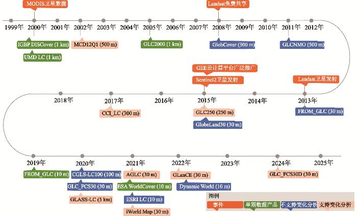
土地覆盖及其变化是全球变化研究中的重要组成部分,在气候变化研究、生物多样性保护、全球碳循环、水循环监测等重大需求中发挥不可替代的作用。在过去几十年里,随着卫星遥感技术、计算机存储与计算能力的不断提升,全球土地覆盖制图与变化监测研究取得了重要进展,空间分辨率从1 km提高至10~30 m,时间更新频次也从单期制图发展为逐年更新。本文全面梳理了国内外公开发布的21套全球土地覆盖产品,从土地覆盖分类体系、模型算法以及数据产品3个方面进行了综述。首先,系统性归纳当前全球土地覆盖产品的分类体系,阐明了各自的特色和优缺点;其次,从全球土地覆盖制图和长时序变化监测两个方面梳理了产品算法模型的发展历程,评估了全球土地覆盖研究的不同发展阶段和总体发展趋势;最后,阐述了当前全球土地覆盖研究中存在的主要问题,提出了该方向未来发展的几点思考。
张肖 , 刘良云 , 艾卫涛 . 全球土地覆盖制图与变化监测研究进展与展望[J]. 地理科学, 2026 , 46(1) : 40 -53 . DOI: 10.13249/j.cnki.sgs.20240643
Land cover and its changes are an important part of global change research, and play an irreplaceable role in climate change research, biodiversity conservation, the global carbon and water cycles monitoring, as well as other major needs. As an essential descriptor of the Earth’s surface, land cover provides a fundamental basis for understanding human-environment interactions and assessing ecosystem functions. Over the past few decades, with the continuous improvement of satellite remote sensing technology, the rapid growth of data storage capacity, and the development of high-performance computing platforms, global land cover mapping and change monitoring have made remarkable progress. The spatial resolution of available products has increased from the early 1 km scale to today’s 10-30 m range, enabling a more detailed characterization of heterogeneous landscapes. Meanwhile, the temporal frequency has evolved from single-period mapping toward multi-year and annual land-cover change monitoring, greatly enhancing our ability to capture dynamic land processes and long-term environmental transitions. In this study, we collected 21 publicly released global land cover products at home and abroad, and then comprehensively summarize their characteristics from three aspects: land cover classification system, methodology and dataset/products. First, we systematically summarized the land-cover classification system of current global land cover products into three groups, and further clarified their characteristics, advantages and disadvantages. Then, we sorted out the development history of the global land-cover algorithms from single land-cover mapping and time series land cover change monitoring, and further evaluated the different development stages and overall development trends of the global land cover research. Finally, the main problems existing in the current global land cover research are described, and some thoughts on the future development of this direction are put forward, particularly regarding the need for harmonized standards, higher spatiotemporal consistency, and better validation frameworks.
表1 IGBP全球土地覆盖分类体系Table 1 IGBP global land cover classification system |
| 编号 | 名称 | 地类详细描述 |
| 1 | 常绿针叶林 | 以常绿针叶林为主,树冠高度>2 m,树木覆盖度>60% |
| 2 | 常绿阔叶林 | 以常绿阔叶树和棕榈树为主,树冠高度>2 m,树木覆盖度>60% |
| 3 | 落叶针叶林 | 以落叶针叶树(落叶松)为主,树冠高度>2 m,树木覆盖度>60% |
| 4 | 落叶阔叶林 | 以落叶阔叶树为主,树冠高度>2 m,树木覆盖度>60% |
| 5 | 混交林 | 以落叶或常绿(各占40%~60%)树种为主,树冠高度>2 m,树木覆盖度>60% |
| 6 | 密闭灌木地 | 以多年生木本植物为主,覆盖度>60%,高度1~2 m |
| 7 | 开放灌木地 | 以多年生木本植物为主,覆盖度为10%~60%,高度1~2 m |
| 8 | 有林稀树草原 | 树木覆盖度为30%~60%,树冠高度>2 m |
| 9 | 稀树草原 | 树木覆盖度为10%~30%,树冠高度>2 m |
| 10 | 草地 | 以一年生草本植物为主,高度<2 m |
| 11 | 永久湿地 | 永久淹没的土地,水覆盖度为30%~60%,植被覆盖度>10% |
| 12 | 耕地 | 至少60%的面积为可耕作的农田 |
| 13 | 城镇和建成区 | 不透水面积至少占30%,包括建筑材料、沥青和车辆等 |
| 14 | 耕地/自然植被镶嵌体 | 由耕地、乔木、灌木和草本植被组成的混合用地,其中耕地为小规模种植(面积占比为40%~60%) |
| 15 | 永久冰雪 | 指每年至少有10个月,至少60%的区域被冰雪覆盖 |
| 16 | 裸地 | 至少60%的区域为无植被贫瘠区(沙地、岩石、土壤),植被覆盖度<10% |
| 17 | 水体 | 至少60%的区域被永久性水体覆盖 |
表2 欧空局(ESA)气候变化倡议发展FAO LCCS全球土地覆盖分类体系Table 2 FAO LCCS global land-cover classification system developed by ESA Climate Change Initiative |
| 编号 | 名称 | 地类详细描述 |
| 10 | 旱地 | 无灌溉设施,靠天然降水生长作物的耕地 |
| 20 | 水浇地 | 有水源保证和灌溉设施,在一般年景能正常灌溉的耕地 |
| 30 | 耕地/自然植被镶嵌体 | 耕地占比>50%,自然植被(林地、灌木、禾本植物)占比<50% |
| 40 | 自然植被/耕地镶嵌体 | 自然植被(林地、灌木、禾本植物)占比>50%,耕地占比<50% |
| 50 | 常绿阔叶林 | 常绿阔叶树木覆盖,覆盖度>15% |
| 60 | 落叶阔叶林 | 落叶阔叶树木覆盖,覆盖度>15% |
| 70 | 常绿针叶林 | 常绿针叶树木覆盖,覆盖度>15% |
| 80 | 落叶针叶林 | 落叶针叶树木覆盖,覆盖度>15% |
| 90 | 混交林 | 阔叶和针叶混合分布 |
| 100 | 林灌/禾本植被镶嵌体 | 林灌占比>50%,禾本植被占比<50% |
| 110 | 禾本植被/林灌镶嵌体 | 禾本植被占比>50%,林灌占比<50% |
| 120 | 灌木地 | 通常指的是低覆盖度的矮林地和灌丛林地 |
| 130 | 草地 | 指生长草本植物为主的土地 |
| 140 | 地衣与苔藓 | 地衣与苔藓覆盖区域 |
| 150 | 稀疏植被 | 林地、灌木、禾本植物覆盖,覆盖度<15% |
| 160 | 有林的淡水洪泛区 | 通常指下垫面为淡水,上层覆盖有林地(如:木本沼泽) |
| 170 | 有林的咸水洪泛区 | 通常指下垫面为咸水,上层覆盖有林地(如:红树林) |
| 180 | 灌丛/草本植被覆盖的洪泛区 | 灌丛或草本覆盖的沼泽 |
| 190 | 城镇 | 指城乡居民点及外围的工矿和交通用地等 |
| 200 | 裸地 | 指基本无植被覆盖的土地 |
| 210 | 水体 | 陆地水域 |
| 220 | 永久性冰雪 | 被冰雪常年覆盖的区域 |
表3 基础土地覆盖分类体系Table 3 Details of basic land-cover classification system containing 10 categories |
| 编号 | 名称 | 地类详细描述 |
| 1 | 耕地 | 用于农作物种植的土地,包括:旱地、灌溉农田、菜地等 |
| 2 | 林地 | 树木(常绿/落叶、阔叶/针叶)覆盖土地,覆盖度>30% |
| 3 | 灌木地 | 灌木或者灌丛覆盖区域,包括:山地灌丛和高山灌丛等 |
| 4 | 草地 | 指生长草本植物为主的土地 |
| 5 | 湿地 | 通常指陆地与水域交接区域,生长湿生/沼生植被的土壤过湿地带 |
| 6 | 苔原 | 指高寒气候环境下,通常覆盖低矮植被(地衣、苔藓、草本和小灌丛等) |
| 7 | 城镇或建成区 | 指城乡居民点及外围的工矿和交通用地等 |
| 8 | 水体 | 陆地水域,包括:河流、湖库、坑塘等 |
| 9 | 裸地 | 指基本无植被覆盖的土地,包括:荒漠、裸岩、沙地等 |
| 10 | 冰雪 | 常年被冰雪覆盖的土地 |
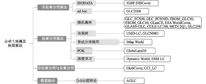
表4 全球土地覆盖制图与变化监测数据产品Table 4 Details of 21 global land-cover mapping and dynamic monitoring products |
| 数据集 名称 | 数据 源 | 分辨 率 | 时间覆盖年 份(年、月) | 分类 体系 | 是否支持 变化监测 | 更新 频率 | 总体 精度 | 参考 文献 |
| IGBP DISCover | AVHRR | 1 km | | IGBP 17类 | 否 | 单期 | 66.9% | [14] |
| GLC2000 | SPOT4 VGT | 1 km | | FAO LCCS 22类 | 否 | 单期 | 68.6% | [18] |
| UMD_LC | AVHRR | 1 km | 1992—1993 | 简化IGBP 14类 | 否 | 单期 | 65.0% | [15] |
| MCD12Q1 | MODIS | 500 m | 2001年至今 | IGBP 17类 | 是 | 逐年 | 74.8% | [16] |
| GlobCover | MERIS | 300 m | 2005、2009 | FAO LCCS 22类 | 否 | 2期 | 73.1% | [17] |
| GLCNMO | MODIS | 500 m | 2003、2008 | FAO LCCS 20类 | 否 | 2期 | 77.9% | [26] |
| CGLS-LC100 | PROBA-V | 100 m | 2015—2019 | FAO LCCS 22类 | 否 | 逐年 | (80.2±0.7)% | [19] |
| CCI-LC | MERIS, SPOT, PROBA | 300 m | 1992年至今 | FAO LCCS 22类 | 是 | 逐年 | 71.45% | [20] |
| GLASS-GLC | AVHRR | 5 km | 1982—2015 | 基础分类体系 8类 | 是 | 逐年 | 82.81% | [27] |
| GLC250 | MODIS | 250 m | 2001、2010 | 基础分类体系 7类 | 是 | 2期 | 75.17% | [28] |
| FROM_GLC30 | Landsat | 30 m | 2010—2017 | 基础分类体系 10类 | 否 | 3期 | 72.43% | [12] |
| GlobeLand30 | Landsat | 30 m | 2000—2020 | 基础分类体系 10类 | 不建议 | 3期 | (80.33±0.2)% | [11] |
| GLC_FCS30 | Landsat | 30 m | 1985—2020 | FAO LCCS 30类 | 否 | 每5 a | 82.5% | [13] |
| GLC_FCS30D | Landsat | 30 m | 1985—2022 | FAO LCCS 35类 | 是 | 2000年后逐年 | (80.88±0.27)% | [29] |
| AGLC | Landsat | 30 m | 2000—2015 | 基础分类体系 10类 | 是 | 逐年 | 79.5% | [21] |
| GLanCE | Landsat | 30 m | 2000—2020 | 基础分类体系 7类 | 是 | 逐年 | (77.0±2.0)% | [25] |
| iMap World | Landsat | 30 m | 1985—2020 | 基础分类体系 10类 | 是 | 逐年 | 80.6% | [30] |
| FROM_GLC10 | Sentinel 2 | 10 m | 2017 | 基础分类体系 10类 | 否 | 单期 | 72.76% | [31] |
| ESA WorldCover | Sentinel-2 | 10 m | 2020、2021 | 基础分类体系 11类 | 否 | 2期 | 74.40% | [22] |
| ESRI LC | Sentinel 2 | 10 m | 2017年至今 | 基础分类体系 10类 | 不建议 | 逐年 | >85% | [23] |
| Dynamic World | Sentinel 2 | 10 m | 2015年至今 | 基础分类体系 9类 | 不建议 | 逐日 | 78.80% | [24] |
| [1] |
陈军, 陈晋, 宫鹏, 等. 全球地表覆盖高分辨率遥感制图[J]. 地理信息世界, 2011, 9(2): 12-14.
Chen Jun, Chen Jin, Gong Peng et al. Higher resolution global cover mapping. Journal of Spatio-temporal Information, 2011, 9(2): 12-14.
|
| [2] |
Song X P, Hansen M C, Stehman S V et al. Global land change from 1982 to 2016[J]. Nature, 2018, 560(7720): 639-643.
|
| [3] |
刘纪远, 张增祥, 徐新良, 等. 21世纪初中国土地利用变化的空间格局与驱动力分析[J]. 地理学报, 2009, 64(12): 1411-1420.
Liu Jiyuan, Zhang Zengxiang, Xu Xinliang et al. Spatial patterns and driving forces of land use change in China in the early 21st century. Acta Geographica Sinica, 2009, 64(12): 1411-1420.
|
| [4] |
董金玮, 匡文慧, 刘纪远. 遥感大数据支持下的全球土地覆盖连续动态监测[J]. 中国科学: 地球科学, 2018, 48(2): 259-260
Dong Jinwei, Kuang Wenhui, Liu Jiyuan. Continuous land cover change monitoring in the remote sensing big data era. Science China Earth Sciences, 2018, 48(2): 259-260.
|
| [5] |
Foley J A, Defries R, Asner G P et al. Global consequences of land use[J]. Science, 2005, 309(5734): 570-574.
|
| [6] |
Hansen M C, Loveland T R. A review of large area monitoring of land cover change using Landsat data[J]. Remote Sensing of Environment, 2012, 122: 66-74.
|
| [7] |
Hansen M C, Potapov P V, Moore R et al. High-resolution global maps of 21st-century forest cover change[J]. Science, 2013, 342(6160): 850-853.
|
| [8] |
宫鹏, 张伟, 俞乐, 等. 全球地表覆盖制图研究新范式[J]. 遥感学报, 2016, 20(5): 1002-1006
Gong Peng, Zhang Wei, Yu Le et al. New research paradigm for global land cover mapping. Journal of Remote Sensing, 20(5): 1002-1016.
|
| [9] |
Song X P. The future of global land change monitoring[J]. International Journal of Digital Earth, 2023, 16(1): 2279-2300.
|
| [10] |
Grekousis G, Mountrakis G, Kavouras M. An overview of 21 global and 43 regional land-cover mapping products[J]. International Journal of Remote Sensing, 2015, 36(21): 5309-5335.
|
| [11] |
Chen J, Chen J, Liao A et al. Global land cover mapping at 30 m resolution: A POK-based operational approach[J]. ISPRS Journal of Photogrammetry and Remote Sensing, 2015, 103: 7-27.
|
| [12] |
Gong P, Wang J, Yu L et al. Finer resolution observation and monitoring of global land cover: First mapping results with Landsat TM and ETM+ data[J]. International Journal of Remote Sensing, 2013, 34(7): 2607-2654.
|
| [13] |
Zhang X, Liu L, Chen X et al. GLC_FCS30: Global land-cover product with fine classification system at 30 m using time-series Landsat imagery[J]. Earth System Science Data, 2021, 13(6): 2753-2776.
|
| [14] |
Loveland T R, Reed B C, Brown J F et al. Development of a global land cover characteristics database and IGBP DISCover from 1 km AVHRR data[J]. International Journal of Remote Sensing, 2000, 21(6-7): 1303-1330.
|
| [15] |
Hansen M C, Defries R S, Townshend J R G et al. Global land cover classification at 1 km spatial resolution using a classification tree approach[J]. International Journal of Remote Sensing, 2000, 21(6-7): 1331-1364.
|
| [16] |
Friedl M A, Sulla-Menashe D, Tan B et al. MODIS Collection 5 global land cover: algorithm refinements and characterization of new datasets[J]. Remote Sensing of Environment, 2010, 114(1): 168-82.
|
| [17] |
Defourny P, Kirches G, Brockmann C et al. Land Cover CCI: Product User Guide Version 2 [R]. London, UK: UCL-Geomatics, 2018.
|
| [18] |
Bontemps S, Defourny P, Bogaert E V et al. GlobCover 2009—Products Description and Validation Report [R]. Bergen: UCLouvain & ESA Team, 2010.
|
| [19] |
Bartholomé E, Belward A S. GLC2000: A new approach to global land cover mapping from Earth observation data[J]. International Journal of Remote Sensing, 2005, 26(9): 1959-1977.
|
| [20] |
Buchhorn M, Lesiv M, Tsendbazar N-E et al. Copernicus Global Land Cover Layers—Collection 2[J]. Remote Sensing, 2020, 12(6): 1044.
|
| [21] |
许晓聪, 李冰洁, 刘小平, 等. 全球2000年—2015年30 m分辨率逐年土地覆盖制图[J]. 遥感学报, 2021, 25(9): 1896-1916
Xu Xiaochong, Li Bingjie, Liu Xiaoping et al. Mapping annual global land cover changes at a 30 m resolution from 2000 to 2015. National Remote Sensing Bulletin, 2021, 25(9): 1896-1916.
|
| [22] |
Zanaga D, Van De Kerchove R, De Keersmaecker W et al. ESA WorldCover 10 m 2020 v100 [J]. Zenodo: Geneve, Switzerland, 2021.
|
| [23] |
Karra K, Kontgis C, Statman-Weil Z et al. Global land use/land cover with Sentinel 2 and deep learning [J]. IEEE International Geoscience and Remote Sensing Symposium, 2021: 4704-4707.
|
| [24] |
Brown C F, Brumby S P, Guzder-Williams B et al. Dynamic World, Near real-time global 10 m land use land cover mapping[J]. Scientific Data, 2022, 9(1): 251.
|
| [25] |
Friedl M A, Woodcock C E, Olofsson P et al. Medium spatial resolution mapping of global land cover and land cover change across multiple decades from Landsat[J]. Frontiers in Remote Sensing, 2022, 3: 894571.
|
| [26] |
Tateishi R, Hoan N T, Kobayashi T et al. Production of global land cover data – GLCNMO2008[J]. Journal of Geography and Geology, 2014, 6(3): 99-122.
|
| [27] |
Liu H, Gong P, Wang J et al. Annual dynamics of global land cover and its long-term changes from 1982 to 2015[J]. Earth Syst Sci Data, 2020, 12(2): 1217-1243.
|
| [28] |
Wang J, Zhao Y, Li C et al. Mapping global land cover in 2001 and 2010 with spatial-temporal consistency at 250 m resolution[J]. ISPRS Journal of Photogrammetry and Remote Sensing, 2015, 103: 38-47.
|
| [29] |
Zhang X, Zhao T, Xu H et al. GLC_FCS30D: The first global 30 m land-cover dynamics monitoring product with a fine classification system for the period from 1985 to 2022 generated using dense-time-series Landsat imagery and the continuous change-detection method[J]. Earth Syst Sci Data, 2024, 16(3): 1353-81.
|
| [30] |
Liu H, Gong P, Wang J et al. Production of global daily seamless data cubes and quantification of global land cover change from 1985 to 2020—iMap World 1.0 [J]. Remote Sensing of Environment, 2021, 258: 112364.
|
| [31] |
Gong P, Liu H, Zhang M et al. Stable classification with limited sample: Transferring a 30-m resolution sample set collected in 2015 to mapping 10 m resolution global land cover in 2017[J]. Science Bulletin, 2019, 64(6): 370-373.
|
| [32] |
Homer C, Dewitz J, Jin S et al. Conterminous United States land cover change patterns 2001—2016 from the 2016 national land cover database[J]. ISPRS Journal of Photogrammetry and Remote Sensing, 2020, 162: 184-199.
|
| [33] |
Liu J, Liu M, Deng X et al. The land use and land cover change database and its relative studies in China[J]. Journal of Geographical Sciences, 2002, 3: 27-34.
|
| [34] |
Gislason P O, Benediktsson J A, Sveinsson J R. Random forests for land cover classification[J]. Pattern Recognition Letters, 2006, 27(4): 294-300.
|
| [35] |
Gómez C, White J C, Wulder M A. Optical remotely sensed time series data for land cover classification: A review[J]. ISPRS Journal of Photogrammetry and Remote Sensing, 2016, 116: 55-72.
|
| [36] |
Belgiu M, Drăguţ L. Random forest in remote sensing: A review of applications and future directions[J]. ISPRS Journal of Photogrammetry and Remote Sensing, 2016, 114: 24-31.
|
| [37] |
刘书含, 顾行发, 余涛, 等. 高分一号多光谱遥感数据的面向对象分类[J]. 测绘科学, 2014, 39(12): 91-94.
Liu Shuhan, Gu Xingfa, Yu Tao et al. Object-oriented classification method based on GF-1 multi-spectral remote sensing image. Science of Surveying and Mapping, 2014, 39(12): 91-94.
|
| [38] |
Parelius E J. A review of deep-learning methods for change detection in multispectral remote sensing images[J]. Remote Sensing, 2023, 15(8): 2092.
|
| [39] |
Li B, Xu X, Liu X et al. An improved global land cover mapping in 2015 with 30 m resolution (GLC-2015) based on a multisource product-fusion approach[J]. Earth Syst Sci Data, 2023, 15(6): 2347-2373.
|
| [40] |
Ban Y, Gong P, Giri C. Global land cover mapping using earth observation satellite data: Recent progresses and challenges[J]. ISPRS Journal of Photogrammetry and Remote Sensing, 2015, 103: 1-6.
|
| [41] |
Huang C, Goward S N, Masek J G et al. Development of time series stacks of Landsat images for reconstructing forest disturbance history[J]. International Journal of Digital Earth, 2009, 2(3): 195-218.
|
| [42] |
Ye S, Rogan J, Zhu Z et al. A near-real-time approach for monitoring forest disturbance using Landsat time series: Stochastic continuous change detection[J]. Remote Sensing of Environment, 2021, 252: 112167.
|
| [43] |
Zhu Z. Change detection using landsat time series: A review of frequencies, preprocessing, algorithms, and applications[J]. ISPRS Journal of Photogrammetry and Remote Sensing, 2017, 130: 370-384.
|
| [44] |
Mi J, Liu L, Zhang X et al. Impact of geometric misregistration in GlobeLand30 on land-cover change analysis: A case study in China[J]. Journal of Applied Remote Sensing, 2022, 16(01): 014516-014516.
|
| [45] |
Woodcock C E, Allen R G, Anderson M C. Free access to Landsat imagery[J]. Science, 2008, 320(5879): 1011.
|
| [46] |
Friedl M A, Mciver D K, Hodges J C F et al. Global land cover mapping from MODIS: Algorithms and early results[J]. Remote Sensing of Environment, 2002, 83: 287-302.
|
| [47] |
Gorelick N, Hancher M, Dixon M et al. Google Earth Engine: Planetary-scale geospatial analysis for everyone[J]. Remote Sensing of Environment, 2017, 202: 18-27.
|
| [48] |
Drusch M, Del Bello U, Carlier S et al. Sentinel-2: ESA’s optical high-resolution mission for GMES operational services[J]. Remote Sensing of Environment, 2012, 120: 25-36.
|
| [49] |
Liu L, Zhang X, Gao Y et al. Finer-resolution mapping of global land cover: Recent developments, consistency analysis, and prospects[J]. Journal of Remote Sensing, 2021, 2021: 1-38.
|
| [50] |
Zhao T, Zhang X, Gao Y et al. Assessing the accuracy and consistency of six fine-resolution global land cover products using a novel stratified random sampling validation dataset[J]. Remote Sensing, 2023, 15(9): 2285.
|
| [51] |
Gao Y, Liu L, Zhang X et al. Consistency analysis and accuracy assessment of three global 30-m land-cover products over the European Union using the LUCAS dataset[J]. Remote Sensing, 2020, 12(21): 3479.
|
| [52] |
Wang Y, Sun Y, Cao X et al. A review of regional and Global scale Land Use/Land Cover (LULC) mapping products generated from satellite remote sensing[J]. ISPRS Journal of Photogrammetry and Remote Sensing, 2023, 206: 311-334.
|
| [53] |
陈军, 张俊, 张委伟, 等. 地表覆盖遥感产品更新完善的研究动向[J]. 遥感学报, 2016, 20(5): 991-1001.
Chen Jun, Zhang Jun, Zhang Weiwei et al. Continous updating and refinement of land cover data product. Journal of Remote Sensing, 2016, 20(5): 991-1001.
|
| [54] |
Olofsson P, Foody G M, Herold M et al. Good practices for estimating area and assessing accuracy of land change[J]. Remote Sensing of Environment, 2014, 148: 42-57.
|
| [55] |
李劲东. 中国高分辨率对地观测卫星遥感技术进展[J]. 前瞻科技, 2022, 1(1): 112-125.
Li Jindong. Advances in high-resolution earth observation satellite remote sensing technologies in China. Science and Technology Foresight, 2022, 1(1): 112-125.
|
| [56] |
Li Z, He W, Cheng M et al. SinoLC-1:The first 1 m resolution national-scale land-cover map of China created with a deep learning framework and open-access data[J]. Earth Syst Sci Data, 2023, 15(11): 4749-4780.
|
| [57] |
Shi Q, Zhu J, Liu Z et al. The last puzzle of global building footprints—Mapping 280 million buildings in east asia based on vhr images[J]. Journal of Remote Sensing, 2024, 4: 0138.
|
| [58] |
Matricardi E a T, Skole D L, Costa O B et al. Long-term forest degradation surpasses deforestation in the Brazilian Amazon[J]. Science, 2020, 369(6509): 1378-1382.
|
| [59] |
Stanimirova R, Tarrio K, Turlej K et al. A global land cover training dataset from 1984 to 2020[J]. Sci Data, 2023, 10(1): 879.
|
| [60] |
Stehman S V, Pengra B W, Horton J A et al. Validation of the U. S. Geological survey’s land change monitoring, assessment and projection (LCMAP) collection 1. 0 annual land cover products 1985—2017[J]. Remote Sensing of Environment, 2021, 265: 112646.
|
| [61] |
D'andrimont R, Verhegghen A, Meroni M et al. LUCAS Copernicus 2018: Earth-observation-relevant in-situ data on land cover throughout the European Union[J]. Earth System Science Data, 2020, 13(3): 1119-1133.
|
| [62] |
Fritz S, Mccallum I, Schill C et al. Geo-Wiki. Org: The use of crowdsourcing to improve global land cover[J]. Remote Sensing, 2009, 1(3): 345-354.
|
| [63] |
Shi Q, He D, Liu Z et al. Globe230k: A benchmark dense-pixel annotation dataset for global land cover mapping[J]. Journal of Remote Sensing, 2023, 3: 78.
|
| [64] |
徐丹青, 吴一全. 光学遥感图像目标检测的深度学习算法研究进展[J]. 遥感学报, 2024, 28(12): 3045-3073.
Xu Danqing, Wu Yiquan. Research progress of deep learning algorithms for object detection in optical remote sensing images. National Remote Sensing Bulletin, 2024, 28(12): 3045-3073.
|
/
| 〈 |
|
〉 |