张建明 , 王鹏龙, 马宁, 张超
兰州大学资源环境学院,甘肃 兰州 730000
ZHANG Jian-ming, WANG Peng-long, MA Ning, ZHANG Chao
中图分类号: TP79
文献标识码: A
文章编号: 1000-0690(2012)12-1530-08
收稿日期: 2011-09-6
修回日期: 2012-06-13
网络出版日期: 2012-12-20
版权声明: 2012 《地理科学》编辑部 本文是开放获取期刊文献,在以下情况下可以自由使用:学术研究、学术交流、科研教学等,但不允许用于商业目的.
基金资助:
作者简介:
作者简介:张建明(1964-),男,陕西勉县人,副教授,从事环境遥感与地学建模方面的教学与科研工作。E-mail:jmzhang@lzu.edu.cn.
展开
摘要
基于1999年和2010年的Landsat ETM+和TM影像,以单窗算法反演了兰州市地表温度,研究兰州市最近10 a的城市热岛时空分布以及演变特征。研究结果表明:兰州市城市热岛的空间分布与延展与城市建城区的扩展相一致,热岛范围不断扩大,次中温和中温区大面积减少,相应的次高温和高温区大面积增加,热岛强度明显增强;除了城市下垫面覆盖类型,黄河低温带亦逐渐成为影响城市热岛分布的重要因子。各土地利用类型的平均温度均有所升高,建设用地和未利用地温度最高,对热岛效应贡献最大,是城市热岛的主要贡献因子,绿地和水体能够很好的缓解热岛效应。地表温度和信息指数NDVI、MNDWI、NDBI、NDBaI在兰州市河谷空间格局上显著相关,存在很好的对应关系。
关键词:
Abstract
With the progress of urbanization, Urban Heat Island (UHI) has been becoming a key factor in deteriorating the urban ecological environment. Studying spatial-temporal evolution and its cause of typical area′s UHI and quantitatively evaluating effect from rapid urbanization on urban heat environment will provide theoretical foundation for relieving UHI effect and also have some useful reference value for ecological environment planning of urban planning. Based on LandsatETM+ and TM images of Lanzhou in 1999 and 2010, with the aid of GIS and RS, this article has retrieved the land surface temperature (LST) of Lanzhou City by Qin’s mono-window algorithm, and then analyzed spatial-temporal pattern and evolution characters of UHI in Lanzhou City in this decade, and the results show that: 1) The spatial pattern and stretch of UHI are consistent with distribution of built district in Lanzhou City. With the expansion of built district, UHI area constantly expanded and the area of less medium temperature and medium temperature had a large reduction, accordingly, the area of less high temperature and high temperature had a large increase, and consequently UHI intension obviously enhanced. Also, as building density of urban area has been increasing gradually, besides land use/covers type, low temperature belt caused by the Yellow River has been becoming a key factor in affecting the spatial pattern of UHI, and within a certain distance, it has the trend that LST tends to go down from the Yellow River to both sides. 2) From 1999 to 2010, average LST of each land use/cover type had a increase, and LST of different land use/cover type had obvious difference. LST of urban construction land and unused land was the highest, and they had the largest contribution to UHI effect, that is to say, they are the main contribution factor, on the contrary, green land and waterbody can reduce LST significantly, therefore, rational planning can effectively relieve the UHI effect. 3) This article has achieved 37 profiles from southeast to northwest of basin valley and calculated their land use index values (NDVI、MNDWI、NDBI and NDBaI) and LST, the results show that there existed significant correlation and corresponding relations between LST and the four land use indices.
Keywords:
城市化和工业化造成的人口聚集会引起一系列的生态环境问题[1]。从19世纪早期,英国学者Howard L [2]最早注意到伦敦市中心的气温较郊区高的现象以来,这种由于热量分布差异导致的城市高密度区气温高于周边郊区气温的“城市热岛”效应研究,近几十年来已经在不同纬度、不同类型的城市地区广泛开展[3]。研究典型地区城市热岛的时空演变及其成因,揭示城郊气候变化对全球变暖的响应特征及差异,是全球变化区域响应的重要内容,亦可为提出减缓城市热岛效应措施提供理论依据,已经成为国内外学者关注的焦点[4~6]。
利用气象数据研究城市热岛效应是传统的方法[7~10],尽管传统方法为研究长时间尺度的城市热岛效应演变提供了可能,然而,由于气象站点分布有限,限制了城市热岛效应空间分布的研究。随着遥感技术的发展,通过遥感影像反演地表温度或亮温来研究城市热岛效应受到重视,对北京[11]、上海[12]、西安[13]、成都[14]等地的研究发现,这些平原型城市中心均具有很强的热岛效应,而且日趋显著。
兰州是典型的河谷型城市,快速的城市化引起日益突出的城市热岛等环境问题。白虎志[15]、马玉霞[16]等利用气象数据研究了兰州市城市热岛效应及其时间变化,发现热岛效应有增强的趋势;李国栋等[17]用数值模拟的方法研究了兰州市夏季的城区热岛效应;潘竟虎等[18]利用单时相遥感影像反演了兰州市城区的地表温度,并利用景观指数分析讨论了在不同土地利用的空间组合下,地表温度(LST)和归一化植被指数(NDVI)的空间差异及相互关系。但是,对于河谷型城市的热岛效应的时空演变模式,以及在空间格局上地表温度与土地利用的关系研究还不多见。基于此,本文以兰州市中心城区为研究区,利用遥感影像反演地表温度,定量评估快速城市化对城市热环境的影响,以期为城市规划中的生态环境规划提供有意义的参考。
兰州市地处陇西黄土高原西部,青藏高原的东北缘,地理位置为35°34′20″N~37°07′07″N、102°35′58″E~104°34′29″E,辖五区三县。近10 a兰州市经历了快速的城市化,1999年底,市辖区人口为178.08万人,到2009年底时,已达210.47万人[19]。本研究选取主城区部分,即城关、七里河、安宁和西固4个城区部分,面积235 km2,位于南北两山之间的黄河谷地,并沿黄河呈东西向带状延伸,是典型的河谷型城市。兰州属于典型的大陆性干旱气候,雨量少而集中,多年平均降水量324.8 mm ,年蒸发量1 486 mm,年平均气温9.3℃[18]。由于主城区位于河谷盆地之中,空气流动性差且有大量工业废气排放,致使空气环境质量较差。
采用1999年7月18日的Landsat7 ETM+和2010年8月25日的Landsat5 TM(130/35)为遥感数据源,气象数据来自甘肃省气象局。图像预处理在ENVI4.7中完成。参照1:5万地形图,采用多项式变换、最邻近点重采样几何精校正2010年TM影像,然后将1999年影像配准到2010年影像。在校正过程中均选取了超过30个控制点,误差RMS小于30 m。根据城市土地利用的功能特征和研究需要,将研究区土地利用类型划分为建设用地、未利用地、绿地和水体4种类型,在ArcGIS9.3中采用目视判读、人工解译得到两期的土地利用类型数据。在两期分类结果中均随机取得50个采样点,对照两期的1:5万地形图和谷歌高分辨率影像,对1999年和2010年两期分类结果进行了精度分析,总体精度分别为87.4%和88.7%,满足研究需要。
1.3.1 亮度温度计算
对于TM/ETM+6影像采用下面公式将亮度值DN6转换为大气顶部辐射亮度L6:
TM:
ETM+:
然后利用公式(3)将辐射亮度转化成亮度温度T6:
T6=K2/ln(1+K1/L6) (3)
式(1)(2)和(3)中Lmin、Lmax为热红外波段中最小和最大辐射值,可在图像头文件中获得。 本文对TM6影像Lmin、Lmax分别取1.238(w/m2·sr·µm)和15.303(w/m2·sr·µm);ETM+6影像Lmin、Lmax分别取3.200(w/m2·sr·µm)和12.650 (w/m2·sr·µm)。QDN为像元亮度值,Qmin、Qmax为最小、最大亮度值,这里取Qmin=1和Qmax=255[20];K1、K2为常数[20]:TM6影像K1=607.76 (w/m2·sr·um)、K2=1260.56K;ETM+6影像K1=666.09(w/m2·sr·um)、K2=1282.71K。
1.3.2 地表温度反演
由于受到大气状况、地形、地表热特性等因素的干扰,星上亮度温度与实际地表温度差距较大。Sugita[21] 研究认为在天气晴朗干燥的情况下,亮度温度和地表温度的误差在5~10℃,而空气湿度较大时,这一误差可达15℃以上。本文采用覃志豪提出的单窗算法反演地表温度,这种算法依据地表辐射传输方程而不需要大气校正,当大气参数估计误差不是很大时,用单窗算法反演地表温度的精度<1.5℃[22],当有实测大气探空数据时,误差可减小到0.9K[23]。公式为[24]:
Ts=[a6(1-C6-D6)+(b6(1-C6-D6)+C6+D6)T6-D6Ta]/C6 (4)
式(4)中,a6=-67.355 35,b6=0.458 608,C6、D6 是中间变量,C6=ε6τ6,D6=(1-τ6)[ 1+τ6 (1-ε6)] ,Ta为大气平均作用温度[22]:Ta=16.011 0+0.926 2T0 ;τ6为大气透射率,可根据大气水汽含量(w)估计[22]:当w在0.4~1.6 g/cm2:τ6=0.974 290-0.080 07w,当w为1.6~3.0 g/cm2时:τ6=1.031 412-0.115 36w。大气水汽含量根据杨景梅等的模型估算[25]:w=0.189e+0.342,e为绝对水汽压(hpa),可表示为[26]:e=0.610 8×exp[17.27(T0-273)/(237.3+T0-273)]×RH。其中,T0和RH为近地面气温和相对湿度,采用兰州气象台观测资料,T0:1999年7月18日取302.35K,2010年8月25日取302.25K;RH:1999年7月18日为64%,2010年8月25日为51%。
对于比辐射率的估算,前人做过一些研究[23,27~29],本文研究区主要为城镇,覃志豪[27]的算法充分考虑了城镇类型,所以采用该方法估算比辐射率。首先把两期影像按地表覆盖划分成3种像元类型:水面、城镇和自然表面,然后用下面的方法估算:
水体取εw=0.995;自然像元分为3部分:当NDVI<0.05时为完全裸土,取εs =0.972;当NDVI>0.7时,为完全植被εv=0.986;当NDVI∈[0.05,0.7]时,
ε =PvRvεv +(1-Pv)Rsεs +dε (5)
当为城镇像元时, ε = PvRvεv + (1-Pv)Rmεm +dε (6)
其中,Rv=0.933 2+0.058 5Pv,Rs=0.990 2+0.106 8Pv,Rm=0.988 6+0.128 7Pv,εm=0.970,Rv、 Rs 和Rm分别为植被、裸土和建筑物的温度比率,εm为建筑物的表面发射率[27];研究区地形相对平坦,所以dε(地表各类型之间的相互影响)忽略。Pv为植被覆盖度,当地表为完全裸土时取0;当为完全植被时取1;当NDVI∈[0.05,0.7]时,为混合像元,用下式计算[30]:
Pv =[(NDVI-NDVIs)/(NDVIv-NDVIs)]2 (7)
式(7)中,NDVIs、NDVIv分别取0.05和0.7[27]。
1.3.3 信息指数NDVI、MNDWI、NDBI、NDBaI的提取
以2010年为例,分析土地利用/覆盖在空间格局上和地表温度的关系,根据兰州市的空间形态,在NW-SE方向上,以NW为正方向,每隔1km选取特征剖面,共选取37条特征剖面(图1),并计算特征剖面的土地利用/覆盖信息指数和地表温度。各信息指数包括:归一化植被指数[31](NDVI)、改进的归一化差异水体指数[32](MNDWI)、归一化建筑指数[33](NDBI)和归一化裸土指数[34](NDBaI)。
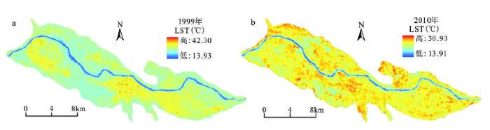
从兰州市地表温度的空间分布(图2),结合土地利用数据(图略)可以得出,兰州市城市热岛的空间分布与延展基本与城市建成区的布局相一致,这体现了城市扩展带来的土地覆盖类型的改变对城市热岛分布的决定作用。城市热岛基本集中在工商业集中和人口密集的地区,温度由这些地区向周围逐渐降低。此外,随着城市规模的扩展和河谷内城市整体建筑密度的增大,城市热岛呈现出以黄河为低温带,在一定范围内,温度有由黄河向两岸逐渐降低的趋势,距离黄河低温带较远的城区,温度较高。这种现象在1999年还不明显,而2010年已比较明显,可见在1999年城市下垫面覆盖类型是影响兰州市城市热岛空间分布的关键因子,但随城市化进程,河谷内整体建筑密度的增大,下垫面覆盖类型以建设用地为主,差异减小,黄河低温带亦逐渐成为影响兰州市热岛空间分布的一个重要因子。
从图2可以看出,1999年地表温度比较高的区域很小,主要集中在黄河南岸商业繁华和人口密集的城关区、七里河区,还有西固工业区,热岛效应较弱,大部分区域温度都比较低;2010年城市高温区面积明显增加,城市热岛效应加强,大部分城区温度都比较高。与1999年相比,高温区不再是孤立的区域,随城市的扩展,高温区都连成了一片,城关区、七里河区、西固区和安宁区都普遍存在高温区。尤其是在东岗镇、九州台、沙井驿和八里窑等地方温度变化最大,这是由于城市的发展,使原来城市边缘的土地利用/覆盖发生了变化,由非建设用地转变为建设用地所致。黄河及两岸的绿化带形成了明显的长条形的相对低温带。 对两期的温度数据的特征统计发现,1999年的温度数据处于夏季中期,温度在13.93~42.30℃之间,平均温度26.54℃;2010年温度数据处于夏末,温度在13.91~38.93℃之间,平均温度29.10℃。1999年的标准差比2010年大,是由于土地覆盖类型差异较大,下垫面均匀性小,导致了比2010年较复杂的热力景观空间格局。
尽管本文1999年的ETM+和2010年TM数据均为夏季,但直接比较地表温度仍会有差别,因此采用正规化方法将地表温度分布范围统一到0和1之间,进一步消除时间的影响。其正归化公式如下[35]:
式(8)中,Ni表示第i个像元正归化后的值,Tsi为第i个像元的地表温度值,Tsmin为地表温度的最小值,Tsmax为地表温度的最大值。
正归化后,为了便于对比分析,两期地表温度数据按照相同的域值等间距划分为:低温、次中温、中温、次高温和高温区5个区间,利用GIS软件,制成地表温度等级图(图3)。
对各温度等级的面积统计可知,1999~2010年,次中温和中温区大面积减少,相应地次高温和高温区大面积增加。2010年次高温区和高温区面积分别增加了71.65 km2和55.64 km2,占研究区总面积的30.46%和23.66%,这表明兰州市近10 a来城市热岛范围有很大的扩展。与此对应,次中温和中温区面积减少了59.14 km2和65.13 km2,占研究区的25.14%和27.69%,这主要是非建设用地随城市发展转变为建设用地和建设用地建筑密度增加与经济繁荣所致。低温区则主要是黄河和部分公园坑塘,面积变化不大。
2.3.1 地表温度和土地利用/覆盖类型的关系
不同下垫面覆盖类型的地表温度有很大差异,对城市热岛效应贡献不同[36]。经统计不同土地利用/覆盖的地表温度情况(表1),可以看出:建设用地的地表平均温度最高,其次是未利用地,绿地和水体的地表平均温度比较低。究其原因,城市建设用地一般由砖石、沥青、水泥和混凝土等组成,有良好的导热性和低比热容,热传导深度大,对太阳辐射的吸收能力强。加之建筑高大密集,使得城市内部热流通不畅,热量难以快速有效地向周边扩散,导致地表温度很高;未利用地主要是裸地和开发用地,导热性较好,比热容较低,因此,在接受太阳辐射后温度上升较快;绿色植被的根系结合土壤能有效地保持水分,使水分通过持续蒸发的形式将地面存储的热量以潜热方式输送到大气,减少地面储热对气温增高的贡献。此外,植被叶面的蒸腾作用作为地-气潜热交换的有效途径,降低了地-气感热作用,故而绿地温度较低;水体由于比热容大,接受太阳辐射后温度上升慢,热辐射值最低,因此温度最低。整体看来,2010年各类土地利用类型的实际温度和正归化后的值均比1999年大,可见,随着城市的发展,以及下垫面土地利用的变化,城市热岛效应明显增强。
表1 各土地利用/覆盖类型的地表温度特征
Table 1 Average LST and normalized LST (mean±S.D) associated with land covers in 1999 and 2010
| 土地类型 | 1999年 | 2010年 | ||
|---|---|---|---|---|
| 实际(℃) | 正归化 | 实际(℃) | 正归化 | |
| 建设用地 | 28.81±2.69 | 0.53±0.09 | 30.16±2.02 | 0.65±0.08 |
| 未利用地 | 26.55±2.32 | 0.45±0.07 | 27.97±5.97 | 0.57±0.23 |
| 绿地 | 24.99±1.79 | 0.40±0.06 | 26.48±2.53 | 0.51±0.10 |
| 水体 | 18.23±3.14 | 0.16±0.11 | 18.79±3.13 | 0.17±0.12 |
同时,计算得到1999年和2010年两期的土地利用/覆盖变化转移矩阵(表2),可以看出,1999~2010年,城区土地利用/覆盖发生了很大变化,建设用地和未利用地大幅度增加,而绿地和水域相应减少,而如表1,建设用地和未利用地的平均温度比较高,绿地和水体的平均温度相对较低,可见,随城市化发展,区域土地利用/覆盖变化是城市热环境改变的重要驱动力。
表2 1999年和2010年土地利用/覆盖转移矩阵(km2)
Table 2 The transfer matrix of land covers from 1999 to 2010 (km2)
| 1999年 | 2010年 | 1999年合计 | |||
|---|---|---|---|---|---|
| 建设用地 | 未利用地 | 绿地 | 水域 | ||
| 建设用地 | 105.45 | 4.84 | 4.22 | 0.34 | 114.85 |
| 未利用地 | 5.06 | 4.57 | 0.52 | 0.02 | 10.17 |
| 绿地 | 35.72 | 27.42 | 33.07 | 0.30 | 96.51 |
| 水域 | 1.77 | 0.31 | 2.39 | 9.30 | 13.77 |
| 2010年合计 | 148.00 | 37.14 | 40.20 | 9.96 | |
| 变化比例/% | 28.86 | 265.19 | -58.35 | -27.67 | |
为衡量不同土地利用/覆盖类型对地表温度的贡献,计算两期数据不同的温度区间各种土地利用/覆盖类型的面积比例组合(表3),可以看出,在高温区,建设用地和未利用地占有绝对优势,随着温度的降低,两者所占比例明显减少,水体和绿地的比重逐渐增加。说明建设用地和未利用地对地表温度有巨大贡献,是城市热岛强度的主要贡献因子。水体和绿地在两期的低温区和次中温区分别占据很大比例,说明水体和绿地可以显著降低地表温度,水体和绿地的这种降温作用对分割和控制城市热岛效应分布具有重要的实际意义,因此,合理的规划水体和绿地有助于缓解城市热岛效应。
表3 1999和2010年各温度等级区不同土地利用/覆盖面积比例(%)
Table 3 Land covers proportion of LST grade in 1999 and 2010 (%)
| 土地类型 | 低温区 | 次中温区 | 中温区 | 次高温区 | 高温区 | |||||
|---|---|---|---|---|---|---|---|---|---|---|
| 1999年 | 2010年 | 1999年 | 2010年 | 1999年 | 2010年 | 1999年 | 2010年 | 1999年 | 2010年 | |
| 建设用地 | 3.76 | 1.79 | 13.18 | 12.69 | 61.20 | 45.46 | 97.88 | 79.02 | 98.69 | 71.74 |
| 未利用地 | 0.33 | 0.99 | 3.11 | 2.77 | 5.85 | 9.96 | 1.12 | 15.32 | 0.79 | 26.77 |
| 绿地 | 4.21 | 3.81 | 79.09 | 57.21 | 32.55 | 44.09 | 0.93 | 5.61 | 0.22 | 1.32 |
| 水域 | 91.70 | 93.41 | 4.62 | 27.34 | 0.40 | 0.49 | 0.07 | 0.05 | 0.30 | 0.17 |
2.3.2 地表温度和各信息指数的空间关系
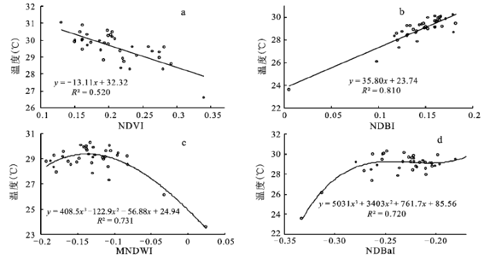
前人关于地表温度和土地利用/覆盖的定量关系已经做了一些研究,有学者得出地表温度和NDVI为坐标的散点图呈三角形,称为Ts/NDVI空间[37~39];有学者在特定的域值范围内,基于统计方法,以一定的间隔(域值间隔0.01)构建了地表温度和信息指数NDVI、NDWI/MNDWI、NDBI、NDBaI的特征空间,均存在很好的定量关系[36,39,40],但是地表温度和各信息指数在特定地形空间格局上是否具有一定关系,研究还不多见。本文重点分析地表温度和各信息指数在河谷型城市兰州市的空间格局上的关系,以反映河谷地形对城市热岛效应的影响。如前文,在沿河谷空间上提取了37条特征剖面,并提取每个剖面上各信息指数和地表温度(LST)的平均值,其中由于水体的特殊性,NDVI和温度正相关[41],先将水体掩膜处理,然后取得NDVI和相应的地表温度(LST′),最后得到它们随距离的空间分布(图略),可以得出,地表温度(LST)和去除水体后的地表温度(LST′)分布趋势大体相同,NDVI和LST′以及MNDWI和LST的空间分布有很好的对应关系;NDBI、NDBaI和LST的空间分布也存在对应关系。因此,对各信息指数和相对应地表温度做回归分析(图4),定量分析各信息指数在河谷空间格局上和地表温度的关系。图4a表明,地表温度(LST′)和NDVI在兰州市河谷空间格局上存在负相关关系,相关系数R2为0.520(p<0.001);图4b表明,地表温度(LST)和NDBI在河谷空间格局上存在正相关关系,相关系数R2为0.810(p<0.001);图4c表明,地表温度(LST)和MNDWI在河谷空间格局上不是简单的线性关系,相关系数R2为0.731(p<0.001),地表温度随MNDWI先缓慢增大,到达峰值后随MNDWI的增大逐渐减小,说明河谷空间上地表温度和水体的关系较复杂;图4d表明,地表温度(LST)和NDBaI在河谷空间格局上亦不是简单的线性关系,相关系数R2为0.720(p<0.001),地表温度随NDBaI的增大的速率有差异,先较小,当NDBaI逐渐增大时趋于平稳,可见在河谷城市中裸土指数增大到一定程度时,地表温度将逐渐稳定。
图4 地表温度和各指数在空间上的关系:
Fig.4 Relationships between LST (LST’) and index values(a)NDVI和温度;(b)NDBI和温度;(c)MNDWI和温度;(d)NDBaI和温度
本文利用GIS和RS方法,研究了兰州市河谷内的城区近10 a的城市热岛效应的时空分布以及演变特征,得出以下结论:
1) 兰州市城市热岛的空间分布与延展基本与城市建成区的布局相一致,随城市的发展,热岛范围不断扩大,次中温和中温区大面积减少,相应地次高温和高温区大面积增加,热岛强度明显增强。除了城市下垫面覆盖类型,黄河低温带亦逐渐成为影响兰州市城市热岛空间分布的重要因子;
2) 1999~2010年,各土地利用/覆盖的平均温度均有所升高,不同土地利用/覆盖类型的地表温度差异较大,建设用地和未利用地温度最高,对热岛效应贡献最大,是城市热岛效应的主要贡献因子,绿地和水体能够很好的缓解热岛效应;
3) 地表温度和信息指数NDVI、MNDWI、NDBI、NDBaI在兰州市河谷空间格局上显著相关,存在很好的对应关系,建立了两者间的定量关系。
本文揭示了河谷型城市兰州市的热岛效应的分布和演变特征,分析了地表温度和各信息指数在河谷空间格局上的分布和对应关系。对于黄河低温带对城市热岛效应的分布和演变,以及河谷地形对城市热岛效应的影响没有进行深入探讨以及定量化,这将是以后研究的重点。
The authors have declared that no competing interests exist.
| [1] |
|
| [2] |
The Climate of London, Deduced from Meteorological Observations [M]: |
| [3] |
|
| [4] |
基于遥感数据的苏州市热岛效应时空变化特征分析 [J].
城市化对于城市环境的一个重要影响是热岛效应。为了研究苏州市20多年来城市化进程对热岛效应的影响,采用遥感与GIS相结合的方法来定量的分析城市热环境的时空变化。根据1986和2004年两个时相的Landsat TM影像提取了研究区的土地覆盖以及亮温信息,在此基础上通过统计分析和GIS的缓冲区分析对这18 a来苏州地区的热岛时空变化及其与土地覆盖变化的关系进行了深入研究。分析结果表明,城市热岛与城区的空间分布之间存在明显的一致性。
|
| [5] |
基于卫星遥感的夏季长春市城区热场分析 [J].https://doi.org/10.3969/j.issn.1000-0690.2006.01.012 URL 摘要
采用先进的遥感手段,能够大面积同步和动态地监测地面热场的分布和变化情况。利用长春市地区 的LANDSAT图象,对于热红外波段遥感图象灰度值和地面温度之间的关系进行了定量的解译,并且采用TM6图象增强和密度分割的方法得到了长春市地面热 场等级图,取得了很好的模拟效果。结果显示了长春市热场的分布具有明显的规律性。城市能耗和下垫面性质对于区域温度有直接的影响,此外,还结合图象分析了 热场分布的形成因素。
|
| [6] |
Microclimatic modeling of the urban thermal environment of Singapore to mitigate urban heat island [J].https://doi.org/10.1016/j.solener.2008.02.008 URL [本文引用: 1] 摘要
This study investigates the urban heat island effect in Singapore and examines the key factors causing this effect. The possibilities of improving heat extraction rate by optimizing air flow in selected hot spots were explored. The effect of building geometry, fa04ade materials and the location of air-conditioning condensers on the outdoor air temperature was explored using computational fluid dynamics (CFD) simulations. It was found that at very low wind speeds, the effect of fa04ade materials and their colours was very significant and the temperature at the middle of a narrow canyon increased up to 2.5°C with the fa04ade material having lower albedo. It was also found that strategically placing a few high-rise towers will enhance the air flow inside the canyon thereby reducing the air temperature. Adopting an optimum H / W ratio for the canyons increased the velocity by up to 35% and reduced the corresponding temperature by up to 0.7°C.
|
| [7] |
城市热岛研究方法概述 [J].https://doi.org/10.3969/j.issn.1004-4574.2008.06.020 URL [本文引用: 1] 摘要
论述了国内外有关城市热岛效应的研究方法,包括传统的气象观测法、基于遥感技术的定量反演法和基于边界层模型的模拟计算法,分析了各种研究方法的进展和优缺点,供城市热岛效应研究方法创新参考。
|
| [8] |
北京地区气温的年代际变化和热岛效应 [J].Magsci 摘要
用北京地区20个气象观测站41年(1960~2000年)的年平均气温记录,研究了北京地区的大尺度气温变化及其热岛效应.结果认为,(1)北京地区气温的年际变化具有大尺度的特点,1981年是显著的跃变点,跃变点比跃变前北京地区气温增加了0.55℃,近40年的增温率为0.25℃/10年.(2)北京城市热岛效应具有典型性.1960~2000年北京城市热岛平均强度接近1℃.随着北京城市建设和城市化速度的加快,北京城市热岛强度也在明显地增加,近40年热岛强度的增温率为0.31℃/10年.
|
| [9] |
Quantification of the influences of wind and cloud on the nocturnal urban heat island of a large city [J].https://doi.org/10.1175/1520-0450(2001)040<0169:QOTIOW>2.0.CO;2 URL 摘要
Analyses taken over all observed weather conditions of daily 0600 EST climate data from a network of monitoring stations in and around the large city of Melbourne, Australia, revealed a 20-yr mean urban heat island (UHI) value of 1.13掳C. The UHI varied seasonally between summer (1.29掳C), spring (1.25掳C), autumn (1.02掳C), and winter (0.98掳C). Investigations undertaken with daily wind speed and cloud amount data enabled a detailed investigation of the relative importance of factors such as the turbulent and radiative exchanges on Melbourne's UHI. Analysis of variance and regression techniques were used to explore these processes and to predict the behavior of the UHI in numerical terms for mean seasonal and annual periods between 1972 and 1991. Over the 20-yr period, analyses of the association among Melbourne's UHI, wind, and cloud revealed that the UHI was inversely proportional to approximately the fourth root of both the wind speed and the cloud amount. This relationship explained more of the UHI variance during summer and the least variance during winter. Increases in the amount of cloud cover and in the frequency of wind speeds in excess of 2.0 m sresulted in a statistically significant (95% confidence level) reduction in UHI magnitude. The influence of wind in limiting Melbourne's UHI magnitude was greatest during clear to near-clear sky conditions. Similarly increases in cloud were most restrictive to UHI development during calm to low wind speeds. Unlike most previous studies, the linear regression analysis presented here revealed that cloud was more limiting than the wind speed to UHI development for all seasons except summer. Contour plots of the UHI are presented for the various associations between each category of cloud and wind. These plots enable a clear visual presentation of the most to least favorable conditions for UHI intensity and development. The analyses indicate that low wind speeds and little or no cloud were typically associated with the largest UHI development. Eight octas of cloud and wind speeds in excess of 5.0 m swere usually associated with modest (but still apparent) UHI development.
|
| [10] |
北京城市热岛效应对气温和降水量的影响 [J].https://doi.org/10.11849/zrzyxb.2006.05.008 Magsci [本文引用: 1] 摘要
借助非参数MannK-endall统计检验方法,对北京市20个气象站44年(1961—2004年)的逐月平均气温和降水资料进行了较为详细的分析。结果表明:①时间上,44年来北京市气温呈持续上升趋势,20世纪80年代为跃变点,跃变后增温趋势更加显著,而降水量呈下降趋势;通过分析5年滑动平均演变图发现,对气温而言,市区增温趋势明显高于郊区,市区和郊区44年来分别以0.44℃/10a和0.01℃/10a的趋势递增,降水量从总体上来说44年来城、郊差异不大,市区和郊区44年来分别以1.82mma/和1.49mma/的趋势递减。②空间上,对年平均气温而言,市区内存在一个明显的上升中心,且等值线较为密集,海淀站Kendall倾斜度高达0.776℃/10a,由于城市热岛效应的存在,1、4、7、10月在市区均存在一个闭合的暖中心,市区内增温幅度大于郊区;对降水量而言,1、4、7、10月在市区和佛爷顶一带均存在着上升中心,降水量呈现上升的趋势,这可能与城市热岛效应的影响有关。
|
| [11] |
Relationship between vegetation greenness and urban heat island effect in Beijing City of China [J].https://doi.org/10.1016/j.proenv.2010.10.157 URL [本文引用: 1] 摘要
In this paper, brightness temperature (Tb) and normalized difference vegetation index (NDVI) were quantitatively derived from Landsat TM images of Beijing City. Feature profiles of Tb and NDVI were drawn in the directions of NE-SW and NW-SE using the technologies of RS and GIS. Laws of spatial distribution of the relationships between Tb and NDVI were discussed. The following conclusions are drawn. (1) there is a significant negative correlation between Tb and NDVI. (2) The less distance between the other profiles and the central profile is, the stronger the negative correlation between Tb and NDVI is. (3) The relationship between Tb and NDVI is affected by the complexity of underlying surface land use structures. The more complex the land use structure is, the stronger the relationship between Tb and NDVI of feature profile is. The spatial correlations between vegetation and temperature are effectively revealed in this paper and thus certain scientific supports for Beijing's urban and greenland planning in the future could be provided.
|
| [12] |
Remote sensing evaluation of urban heat island and its spatial pattern of the Shanghai metropolitan area, China [J].https://doi.org/10.1016/j.ecocom.2009.02.002 URL Magsci [本文引用: 1] 摘要
<h2 class="secHeading" id="section_abstract">Abstract</h2><p id="">With the aid of an integrated GIS/RS-based approach, methods including spatial autocorrelation, semivariance, and fractal analysis were used to quantitatively characterize the patterns of recent urban heat island (UHI) in the Shanghai metropolitan area during 1997 and 2004. Results show that newly emerging bare lands along the coastal areas and on the remote islands were well vegetated or developed for fishery, and therefore had the significant cooling effect. However, with the rapid expansion of the urbanized and urbaning landscapes, the heating effect of impervious surfaces increased in proportion. Spatial scales showed that the average size of homogeneous patches dominated with the urbanized and urbanizing areas increased remarkably, so did the extent and magnitude of hot spots. Given the growing extent and magnitude of UHI on two dates, dramatic land use and cover change in urban fringes and the major satellite towns significantly exacerbated the UHI effect on regional scale. As a whole, both the extent and magnitude of UHI in Shanghai have undergone a significant increase. Further, the patterns of UHI (as indicated by LSTs) implied the existence of spatial correlation on the small and meso scales. A directional analysis of the Hausdorff–Besicovitch dimension showed that in E–S profile of the city, the spatial dependency of UHI was mainly associated with structural variance. Relatively weak spatial dependency associated with structural variance also existed in the direction of NE–SW. As computed, the structural variation accounted for approximately 50% of the total variation. Therefore, random factors also played the significant role in causing the complexity in patterns of UHI.</p>
|
| [13] |
基于Landsat5 TM 数据的西安市城市化进程与热岛效应关系研究[D] . |
| [14] |
成都市热岛效应演变趋势与城市变化关系研究 [J].https://doi.org/10.3969/j.issn.1671-1742.2007.z1.002 URL [本文引用: 1] 摘要
通过卫星遥感信息和遥感图像处理技术,运用2001年、2006 年2个时期的NOAA/AVHRR遥感数据,和同期的CBERS高分辨率遥感数据,辅以地理信息系统技术对成都市主城区2001-2006年间的城市热岛 效应演变及其特征进行了分析,研究了城市扩展情况以及热岛演变与分布特征、城市功能区类型演变等对地表温度空间变动的影响.分析结果表明:(1)2006 年成都城市规模较之2001年明显扩大,以二环、三环路为基本框架的圆状城市布局,转变为沿南北中轴线及卫星城市连接公路方向不断延伸、成都西南西北三环 路外新的高新工业区不断发展的城市布局.(2)2001年至2005年成都城市绿化面积逐年上升,使得二环路内热岛强度普遍偏低.(3)从2001年至 2006年,随城市区域的扩大,成都城市热岛效应增强,热岛温差达8~9℃,局部地方极值达10℃,新的工业园区成为新的热岛中心.
|
| [15] |
兰州城市热岛效应特征及其影响因子研究 [J].https://doi.org/10.3969/j.issn.1671-6345.2005.06.003 URL [本文引用: 1] 摘要
利用1958~2003年兰州及临近两个乡村气象站气温资料,研究了兰州城市热岛效应特征和导致热岛效应季节差异及其年代际变化趋势的主要气象因子.结果表明:近40多年来,兰州城市热岛效应一直呈增强趋势,热岛效应在冬季尤为显著;在日变化中以02:00热岛效应最为明显,而14:00效应较小.冬季逆温层、夏季城市下垫面对热岛效应的季节差异影响较大.城市发展导致热岛效应增强,而部分气象要素的年代际异常加剧了热岛效应.
|
| [16] |
兰州市近50年城市热岛强度变化特征 [J].https://doi.org/10.3969/j.issn.1671-6345.2009.06.005 URL [本文引用: 1] 摘要
利用1956~2005年兰州 市日平均气温、日最高气温和日最低气温,分析了近50年兰州市城市热岛效应变化,并利用城区和郊区3种气温的倾向率计算了城市热岛强度倾向率和热岛增温贡 献率。结果表明:1956~2005年兰州市3种气温的城郊差均呈逐年上升趋势,平均气温、最高气温和最低气温的倾向率分别为每10年0.371℃、 0.169℃和0.654℃,其中,最低气温的城郊差上升最明显。近50年兰州市增温主要发生在后25年(1981~2005年),前25年除城区最低气 温外基本上以降温为主。后25年中,城区年平均气温、最高气温和最低气温倾向率分别为每10年0.789℃、0.997℃和0.625℃,郊区则相应为每 10年0.493℃、0.790℃和0.077℃,其中最高气温增温最显著,最低气温增温最少;以年平均、最高和最低气温表示的城市热岛强度的倾向率分别 为每10年0.395℃、0.188℃和0.674℃,热岛效应对城区增温的贡献率分别达到87.0%、49.6%和100%。冬季城市和郊区的平均气温 和最低气温倾向率最大,但热岛增温贡献率最大的是春、夏季气温,而不是冬季气温;这可能主要与兰州市冬季严重的空气污染有关,因为其对城市热岛有一定的抑 制作用。20世纪80年代以后兰州市热岛效应有增强的趋势,但平均气温和最高气温的热岛增温贡献率除个别季节外有所下降。
|
| [17] |
兰州市城区夏季热场分布与热岛效应研究 [J].
对兰州市城区进行了早、午、晚3个时段各气候要素的流动观测,模拟了兰州市城区夏季3个时段的地面热场。结果显示,兰州市夏季地面热场分布存在明显的规律性和动态演变特征。2006~2007年,在城区和郊区利用两套自动气象站连续进行了气候定点对比观测,结合兰州城区台站近70年和郊区台站近40年的常规气象观测资料,分析兰州市气温、热岛效应及热岛强度的变化特征。热场的时空分布与兰州市城市化过程中土地利用类型、人口密度、城市能耗、建筑容积率和下垫面热力性质等因素的变化有着密切的联系。
|
| [18] |
河谷型城市土地利用类型及格局的热环境效应遥感分析——以兰州市为例 [J].
<p>以河谷型城市兰州为例,采用Landsat ETM+遥感影像为基本数据源,定量反演了地表温度(LST)和植被指数(NDVI),利用GIS空间分析方法,分析了LST和NDVI 在不同土地利用类型之间的差异以及二者之间的定量关系,并引入多样性和聚集度指数,讨论了在不同土地利用的空间组合下,LST和NDVI 的空间差异及相互关系。结果显示:LST和NDVI具有明显的相关性,中心城区LST表现出热岛效应,而NDVI则为低谷效应;土地利用斑块和类型两种尺度水平上LST和NDVI均具有明显负相关的线性关系,城市内部不同土地类型所产生的热环境效应不同;土地利用多样性越丰富、聚集度越小的区域,其温度对地表植被覆盖的敏感性越弱。</p>
|
| [19] |
|
| [20] |
Summary of current radiometric calibration coefficients for LandsatMSS, TM, ETM+, and EO-1 ALI sensors [J].https://doi.org/10.1016/j.rse.2009.01.007 URL [本文引用: 2] 摘要
This paper provides a summary of the current equations and rescaling factors for converting calibrated Digital Numbers (DNs) to absolute units of at-sensor spectral radiance, Top-Of-Atmosphere (TOA) reflectance, and at-sensor brightness temperature. It tabulates the necessary constants for the Multispectral Scanner (MSS), Thematic Mapper (TM), Enhanced Thematic Mapper Plus (ETM+), and Advanced Land Imager (ALI) sensors. These conversions provide a basis for standardized comparison of data in a single scene or between images acquired on different dates or by different sensors. This paper forms a needed guide for Landsat data users who now have access to the entire Landsat archive at no cost.
|
| [21] |
Comparison of land surface temperatures derived from satellite observations with ground truth during FIFE [J].https://doi.org/10.1080/01431169308953993 URL [本文引用: 1] 摘要
Not Available
|
| [22] |
单窗算法的基本大气参数估计方法 [J]. |
| [23] |
Land surface temperature retrieval from LANDSAT TM 5 [J].https://doi.org/10.1016/j.rse.2004.02.003 URL Magsci [本文引用: 2] 摘要
<h2 class="secHeading" id="section_abstract">Abstract</h2><p id="">In this paper, three methods to retrieve the land surface temperature (LST) from thermal infrared data supplied by band 6 of the Thematic Mapper (TM) sensor onboard the Landsat 5 satellite are compared. The first of them lies on the estimation of the land surface temperature from the radiative transfer equation using in situ radiosounding data. The others two are the mono-window algorithm developed by Qin et al. [International Journal of Remote Sensing 22 (2001) 3719] and the single-channel algorithm developed by Jiménez-Muñoz and Sobrino [Journal of Geophysical Research 108 (2003)]. The land surface emissivity (LSE) values needed in order to apply these methods have been estimated from a methodology that uses the visible and near infrared bands. Finally, we present a comparison between the LST measured in situ and the retrieved by the algorithms over an agricultural region of Spain (La Plana de Requena-Utiel). The results show a root mean square deviation (rmsd) of 0.009 for emissivity and lower than 1 K for land surface temperature when the Jiménez-Muñoz algorithm is used.</p>
|
| [24] |
A mono-window algorithm for retrieving land surface temperature from Landsat TM data and its application to the Israel-Egypt border region [J]. |
| [25] |
我国可降水量同地面水汽压关系的经验表达式 [J].https://doi.org/10.3878/j.issn.1006-9895.1996.05.14 Magsci [本文引用: 1] 摘要
本文根据1992~1993年全国20个台站地面及高空气象要素资料,拟合出各个站所在地区整层大气可降水量和有效水汽含量同地面水汽压之间的经验关系式。计算结果表明,可降水量和相应的地面水汽压之间,存在着良好的数值对应关系。仅利用地面水汽压计算出的整层大气可降水量和有效水汽含量,同实际情况符合得很好,平均相对误差普遍小于15%。因此,这些经验关系式具有良好的实际应用价值。
|
| [26] |
|
| [27] |
利用LANDSAT TM6反演地表温度所需地表辐射率参数的估计方法 [J].https://doi.org/10.3969/j.issn.1671-6647.2004.z1.022 URL [本文引用: 4] 摘要
地表温度是地球资源环境动态分析的重要指标.从热红外遥感数据中 反演地表温度通常需要地表比辐射率为已知.因此,地表比辐射率的估计是地表温度遥感反演的关键.陆地卫星Landsat TM有一个热波段(TM6),可以用来反演地表温度.目前共有3种算法可以用来从TM6波段数据中反演地表温度:大气校正法、单窗算法和单通道算法.这3 种算法都需要TM6波段范围内的地表发射率来作为地表温度反演的参数.首先简介这3种反演算法,然后重点探讨TM6的地表发射率估计方法.TM6的星下空 间分辨率为120 m.在这一尺度上,大多数情况下天然地表的构成可以看成是由水面、植被和裸土三种基本类型构成.城镇像元也可看成是由建筑表面和绿化植物构成.根据这几种 地表类型的地表发射率相对较稳定的特性,提出了用TM数据的可见光波段来进行TM6像元的地表发射率的估计.TM3和TM4波段可以用来确定植被叶冠在像 元尺度上的覆盖度.通过这一覆盖度,就可以构建混合像元的地表热辐射构成方程,以便进行地表发射率的简单估计,从而为TM6热波段数据在农业和资源环境监 测中的广泛应用,提供技术支撑.最后,用这一方法来进行华北平原山东省陵县地区的地表发射率估计和地表温度反演.分析表明,这一方法能获得较合理的地表温 度反演结果.
|
| [28] |
On the relationship between thermal emissivity and the normalized difference vegetation index for natural surfaces [J].https://doi.org/10.1080/01431169308904400 URL 摘要
ABSTRACT Despite the universal mantra that “the customer is king,” the role of the customer has so far seemed to have been confined to a passive recipient of products. Recently, however, this traditional perception has been challenged. On the one hand, users are increasingly appreciated as reflexive actors who are actively involved in the evaluation, modif ication, and configuration of products. On the other hand, beyond the established repertoire to access external knowledge through interorganizational networks, firms increasingly attempt to harness user knowledge. These two concurrent shifts do not result in a smooth convergence. Rather, they open up a highly contested terrain in which habitual distinctions between the producer and user are blurred. In this article, we map the evolving terrain of user-producer interaction in innovation processes. Specifically, we contrast more traditional approaches to incorporate customer knowledge with an emerging class of innovative user-producer relationships, provisionally dubbed “co-development.” We then propose a typology of different modes of codevelopment that is organized along two dimensions: the degree of user involvement and the prevailing locus of knowledge production. This typology seeks to capture the heterogeneity of co-development approaches and to provide a conceptual template for further empirical research on user involvement in innovation.
|
| [29] |
Mapping land surface emissivity from NDVI application to European, African, and South American areas [J]. |
| [30] |
On the relation between NDVI,fractional vegetation cover,and leaf area index [J].https://doi.org/10.1016/S0034-4257(97)00104-1 URL [本文引用: 1] 摘要
We use a simple radiative transfer model with vegetation, soil, and atmospheric components to illustrate how the normalized difference vegetation index (NDVI), leaf area index (LAI), and fractional vegetation cover are dependent. In particular, we suggest that LAI and fractional vegetation cover may not be independent quantitites, at least when the former is defined without regard to the presence of bare patches between plants, and that the customary variation of LAI with NDVI can be explained as resulting from a variation in fractional vegetation cover. The following points are made: i) Fractional vegetation cover and LAI are not entirely independent quantities, depending on how LAI is defined. Care must be taken in using LAI and fractional vegetation cover independently in a model because the former may partially take account of the latter; ii) A scaled NDVI taken between the limits of minimum (bare soil) and miximum fractional vegetation cover is insenstive to atmospheric correction for both clear and hazy conditions, at least for viewing angles less than about 20 degrees from nadir; iii) A simple relation between scaled NDVI and fractional vegetation cover, previously described in the literature, is further confirmed by the .simulations; iv) The sensitive dependence of LAI on NDVI when the former is below a value of about 2–4 may be viewed as being due to the variation in the bare soil component.
|
| [31] |
Relationships between percent vegetation cover and vegetation indices [J]. |
| [32] |
利用改进的归一化差异水体指数(MNDWI)提取水体信息的研究 [J].https://doi.org/10.11834/jrs.20050586 Magsci [本文引用: 1] 摘要
在对M cfeeters提出的归一化差异水体指数(NDWI)分析的基础上,对构成该指数的波长组合进行了修改,提出了改进的归一化差异水体指数MNDWI(M odified NDWI),并分别将该指数在含不同水体类型的遥感影像进行了实验,大部分获得了比NDWI好的效果,特别是提取城镇范围内的水体。NDWI指数影像因往往混有城镇建筑用地信息而使得提取的水体范围和面积有所扩大。实验还发现MNDWI比NDWI更能够揭示水体微细特征,如悬浮沉积物的分布、水质的变化。另外,MNDWI可以很容易地区分阴影和水体,解决了水体提取中难于消除阴影的难题。
|
| [33] |
一种利用TM 图像自动提取城镇用地信息的有效方法 [J].https://doi.org/10.11834/jrs.20030107 Magsci [本文引用: 1] 摘要
如何快速、准确与客观地提取城镇用地信息,以获得城镇用地的分布范围和面积资料,是有关城镇问题研究中经常涉及到的一个基本问题,现代遥感技术为这个问题的有效解决提供了强有力的保证,运用提出的归一化建筑指数,从TM图像进行了无锡市城镇用地信息的自动提取,研究结果表明,与传统的计算机分类和手工屏幕数字化方法相比,归一化建筑指数法是一种非常行之有效的方法。
|
| [34] |
Use of normalized difference bareness index in quickly mapping bare areas from TM/ETM+ imagery [ |
| [35] |
不同时相的遥感热红外图像在研究城市热岛变化中的处理方法 [J].
<p>卫星图像的热红外波段已被广泛地用来研究城市热岛效应。由于客观条件的限制,在城市热岛变化的比较研究中,很难获得不同年代的同时相图像,特别是在南方多云雨的地区。所以,这给城市热岛的变化研究带来了很大的困难。为此,采用了将不同时相的热红外图像进行正规化、分级,并制成差值影像图的方法,较好地减少了季相差异的影响,使得不同时相的热红外图像得以对比。为了定量地研究城市热岛(UHI)的变化,还创建了城市热岛比例指数(URI)。该指数通过热岛面积和城市建成区面积的比例关系并赋于不同的权重值来定量地评估热岛现象的变化情况。</p>
|
| [36] |
Remote sensing image-based analysis of the relationship between urban heat island and land use/cover changes [J].https://doi.org/10.1016/j.rse.2005.11.016 URL [本文引用: 2] 摘要
Global warming has obtained more and more attention because the global mean surface temperature has increased since the late 19th century. As more than 50% of the human population lives in cities, urbanization has become an important contributor for global warming. Pearl River Delta (PRD) in Guangdong Province, southern China, is one of the regions experiencing rapid urbanization that has resulted in remarkable Urban Heat Island (UHI) effect, which will be sure to influence the regional climate, environment, and socio-economic development. In this study, Landsat TM and ETM+ images from 1990 to 2000 in the PRD were selected to retrieve the brightness temperatures and land use/cover types. A new index, Normalized Difference Bareness Index (NDBaI), was proposed to extract bare land from the satellite images. Additionally, Shenzhen, which has experienced the fastest urbanization in Guangdong Province, was taken as an example to analyze the temperature distribution and changes within a large city as its size expanded in the past decade. Results show that the UHI effect has become more prominent in areas of rapid urbanization in the PRD region. The spatial distribution of heat islands has been changed from a mixed pattern, where bare land, semi-bare land and land under development were warmer than other surface types, to extensive UHI. Our analysis showed that higher temperature in the UHI was located with a scattered pattern, which was related to certain land-cover types. In order to analyze the relationship between UHI and land-cover changes, this study attempted to employ a quantitative approach in exploring the relationship between temperature and several indices, including the Normalized Difference Vegetation Index (NDVI), Normalized Difference Water Index (NDWI), Normalized Difference Bareness Index (NDBaI) and Normalized Difference Build-up Index (NDBI). It was found that correlations between NDVI, NDWI, NDBaI and temperature are negative when NDVI is limited in range, but positive correlation is shown between NDBI and temperature.
|
| [37] |
A method to make use of thermal infrared temperature and NDVI measurements to infer surface soil water content and fractional vegetation cover [J].https://doi.org/10.1080/02757259409532220 URL [本文引用: 1] 摘要
Application of the technique is demonstrated for an agricultural area in a Pennsylvania watershed. Results of surface soil moisture availability and fractional vegetation cover are qualitatively realistic but the distribution of soil moisture availability is questionable at high fractional vegetation amounts.
|
| [38] |
A simple interpretation of the surface temperature /vegetation index space for assessment of surface moisture status [J]. |
| [39] |
基于MODIS数据的长株潭地区NDBI和NDVI与地表温度的关系研究 [J].https://doi.org/10.3969/j.issn.1000-0690.2009.02.019 URL [本文引用: 2] 摘要
基于4个季节的MODIS影像,计算长株潭地区的地表温度、NDBI和NDVI,比较NDBI和NDVI与地表温度之间关系,对地表城市热岛效应研究的指标NDBI和NDVI进行对比分析。结果表明,NDBI与4个季节的地表温度间都存在明显的线性关系,而NDVI与地表温度间关系并不明显且随季节发生变化,说明NDBI是地表城市热岛效应研究的有效指标,在地表城市热岛效应的季节变化研究中NDBI可作为NDVI的一个附加指标。
|
| [40] |
基于遥感的长沙市城市热岛与土地利用/覆盖变化研究 [J].https://doi.org/10.6046/gtzyyg.2008.04.12 URL Magsci [本文引用: 1] 摘要
<p>基于多时相Landsat TM/ETM+影像,首先计算长沙市地表亮度温度,然后利用NDVI(归一化植被指数)、MNDWI(改进</p><p>的归一化水体指数)、NDBI(归一化建筑指数)和NDBaI(归一化裸土指数)4个指数,采用决策树分类方法对长沙市影像进行</p><p>土地利用/覆盖分类。在此基础上,对长沙市城市热岛的空间分布特征、时空演变特征以及城市热岛与土地利用/覆盖变化和各种影</p><p>响因子之间的关系进行研究。结果表明,随着长沙市城区范围的不断扩张,城市热岛范围也不断增大; 土地利用/覆盖类型的变化</p><p>会改变地表温度的空间分布,城市用地和裸地是城市热岛强度的主要贡献因素,水体和林地具有较好的降温作用。地表温度与4种</p><p>归一化指数的回归分析表明,它们之间存在明显的相关性,不同土地利用/覆盖类型的地表温度存在较大差异。</p>
|
| [41] |
基于遥感影像的城市土地利用生态环境效应研究——以城市热环境和植被指数为例 [J].
城市化过程中,农村的土壤、水面以及植被等土地覆被类型逐渐减少,取而代之的是由沥青、水泥以及金属等组成的不透水表面,这个过程导致地表水分蒸腾减少、径流加速、显热的存储和传输增加以及水质降低等一系列生态环境效应,其中最明显的两个特征就是土地覆被的植被减少、城市热岛的出现。而城市土地利用类型及其空间结构的生态环境效应同时又是城市生态学中的关键问题,其研究对优化城市功能分区和城市规划管理以及城市可持续发展等都具有重要意义。以上海市为例,采用Landsat7的ETM+为基本数据源,首先定量反演了每个像元内的陆地表面温度(LST)和植被指数(NDVI),然后利用GIS中的空间分析功能,将由于城市土地覆被所形成的生态环境效应综合到土地利用的图斑中来,按照这个思路对城市土地利用的生态环境效应进行研究。分析LST、NDVI在不同土地利用类型之间的差异以及二者之间的定量关系,并引入多样性指数(SHDI),讨论了不同土地利用的空间组合下,LST和NDVI的空间差异及相互关系。研究结果显示:LST和NDVI具有明显的相关性,LST大的区域对应NDVI一般都较小,反之亦然;中心城市LST表现出热岛效应,而NDVI则为低谷效应。通过Tamhance T2 post-hoc多重比较发现, LST以及NDVI在两两土地利用类型之间的差异不同。 从土地利用斑块和类型两种尺度水平上建立了LST和NDVI的定量关系,二者具有明显负相关的线性关系,但在不同土地利用类型上二者关系并不同。其中工业仓储、交通用地与公园绿地、农业用地差异最为显著。它们和SHDI之间的关系揭示,LST与土地利用多样性具有正相关关系,而NDVI则与SHDI呈负相关关系,SHDI越大的地区,LST越大,而NDVI越小。由此,可以将LST、NDVI和SHDI作为三个基本指标,来定量评价城市土地利用类型、结构对生态环境的影响,以此作为城市功能分区中生态环境影响评价的参考。也为高性价比的中等分辨率遥感数据与GIS空间分析方法结合在城市规划中的应用提供了一种新的思路。
|

/
| 〈 |
|
〉 |

