王千锁 , 宋友桂, 李吉均
WANG Qian-suo, SONG You-gui, LI Ji-jun
中图分类号: P593.3
文献标识码: A
文章编号: 1000-0690(2015)11-1489-06
通讯作者:
收稿日期: 2014-05-20
修回日期: 2014-10-27
网络出版日期: 2015-11-20
版权声明: 2015 《地理科学》编辑部 本文是开放获取期刊文献,在以下情况下可以自由使用:学术研究、学术交流、科研教学等,但不允许用于商业目的.
基金资助:
作者简介:
作者简介:王千锁(1984-),男,河南三门峡人,博士研究生,主要从事第四纪地质与矿物学研究。E-mail:wangqiansuo@gmail.com
展开
摘要
对黄土高原中部朝那剖面末次冰期-间冰期旋回黄土-古土壤序列色度指标与磁化率对比研究后发现,亮度L*值与Hm(赤铁矿)和Gt(针铁矿)的比值相关性较好,在S0和L1阶段其与Hm和Gt的比值呈正相关,在S1阶段为负相关。红度a*与Hm和Gt的比值有较强的正相关关系,反映土壤发育时期的水热条件。而黄度b*与针铁矿的相关性较好,与低频磁化率χlf使用可以更好地反映土壤的发育程度。色度指标在变化频率和幅度上较磁化率大,能很好地识别S1阶段弱黄土-古土壤层。
关键词:
Abstract
The loess-paleosol sequences on the Chinese Loess Plateau (CLP) record the evolution of East Asian Monsoon. Soil color, a sensitive proxy of paleoclimate, has long been used for soil identification and qualitative determination of soil characteristics. Meanwhile it is also used as an indicator of field soil physics, chemical and biological properties as well as of occurrence of soil process. Here we focus on the characteristics and significance of soil color of Chaona loess-paleosol Sequence in CLP since the last Interglacial period. The study area is located near the town of Chaona (35°7′N,107°12′E) in the central CLP. The loess deposit of sequence is 175 m thick and contains 33 paleosol units. The paleosol within the loess is brownish or reddish with substantial clay skins developed and carbnate nodules are scattered commonly below the soils. Our attention has been given to studies of the last glacial-interglacial cycle and the overlying Holocene paleosol (S0). The last glacial loess (L1) consists of two primary loess units (L1LL1 and L1LL2), separated by a weak soil complex (L1SS). And the last interglacial paleosol (S1) can be further divided into three subunits, including two moderate developed paleosol complexes (S1SS1 and S1SS2) and a loess horizon (S1LL). We compared chromatic indexes with magnetic susceptibility. The results indicated that lightness L* can be good correlation with the ratio of Hm and Gt that reflects the precipitation. Lightness L* has a positive correlation with the ratio of Hm and Gt in since the last glacial period, but there is obvious negative correlation between lightness L* and the ratio of Hm and Gt during the last interglacial period. Meanwhile we find that a positive correlation exists between a* and the ratio of Hm and Gt in the section, which reflects hydrothermal conditions in the soil development period. The value of b* primarily influenced by the content of Gt can be used together with χlf in order to reproduce the development degree of the soil. In contrast to magnetic susceptibility, chroma indexes from S1 paleosol are characterized by high-frequency and high-amplitude variations, which also documents the weak loess-paleosol sequences during the last interglacial period (S1). Furthermore, a* and b* are the major factors that influences L* value significantly. Therefore, Chroma index, a proxy that documents the sensitive and great evidence of climate variations, can be used to develop the complementary study with magnetic susceptibility, which can reconstruct the process of paleoclimate reasonably and reliably.
Keywords:
土壤颜色是土壤最明显的特征之一,是土壤发育程度的重要指示[1]。色度指标由于用量少和方便快捷等优点逐渐在古气候研究中得到了广泛的应用,在黄土高原色度作为夏季风强度代用指标揭示出东亚季风千万年尺度特征[2~8]。黄土-古土壤序列中白度值的变化趋势与第四纪冰期-间冰期旋回的波动特征一致,很好地反映夏季风环流强度变化[9,10]。铁氧化物成分和含量对土壤颜色的影响比较明显,尤其是赤铁矿和针铁矿含量影响土壤的红度与黄度,指示气候的波动[5,11,12]。
黄土高原中部朝那剖面黄土-红粘土序列已有诸多古气候代用指标研究[13~21],但多集中于晚新近纪以来黄土-红粘土研究,尤其是红粘土序列的研究,而朝那剖面末次冰期-间冰期旋回黄土颜色的精细研究还未曾报道。本文在前人研究的基础上对朝那剖面末次间冰期以来黄土-古土壤序列的色度参数L*、a*、b*和特征光谱与磁化率进行详细的对比研究,揭示黄土颜色的变化规律以及色度指示的古气候意义,对于理解和重建末次间冰期以来东亚季风的演化具有十分重要的意义。
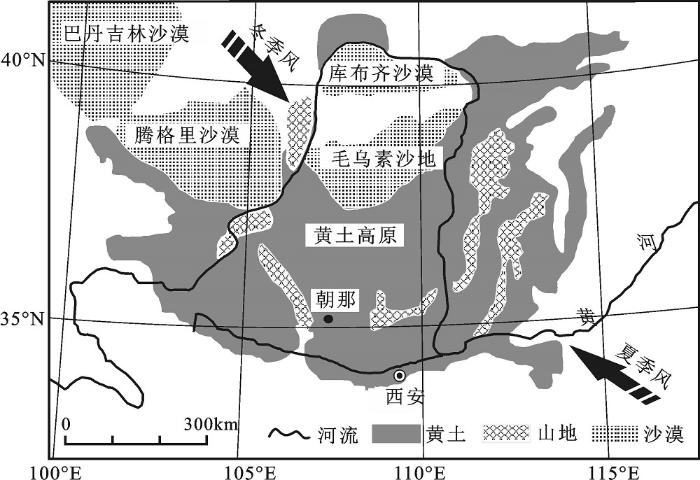
朝那剖面(CN)位于黄土高原中部甘肃省灵台县朝那镇南约5 km 处的郑家什字村(35°7′N,107°12′E)(图1)。研究区气候主要受亚洲季风控制,夏季盛行来自于太平洋的暖湿气流,冬季受西伯利亚高压冷锋控制[18],属暖温带半湿润气候,年均气温8~9℃,最热月均温22~24℃,年降水量350~500 mm[15,17,19]。剖面顶部海拔高度为1 464 m,四周切割强烈,地层出露十分完整。整个黄土-红粘土序列厚300 m,黄土-古土壤序列厚约175 m,由33组古土壤和黄土组成,发育十分典型完整[18,20]。本文选取朝那剖面黄土-古土壤序列上部10.4 m进行研究,采样间距为5 cm,共采得209个样品。剖面自上而下:全新世古土壤(S0)为灰褐色黑垆土,团块结构,见似棱柱状结构,有黑色斑点和白色的碳酸钙薄膜;末次冰期黄土(L1)呈灰黄色到浅灰褐色,团块结构,富含大孔隙,见碳酸盐薄膜和斑点;末次间冰期古土壤(S1)为复合古土壤,上部为浅褐色弱古土壤,中夹浅黄褐色黄土,下部为典型的淋溶古土壤,团块结构,少量淀积粘粒胶膜,未见碳酸钙结核。为保持S1层的完整性,我们的采样达到L2的上部。
CIELAB表色系统是目前主要颜色描述和测量系统之一,该系统中使用L*、a*、b*这3个参量描述任何均匀连续的颜色空间。L*代表亮度,变化于黑(0)与白(100)之间;a*代表红绿彩度(也称红度),变化于绿(-60)和红(+60)之间;b*代表黄蓝彩度(也称黄度),变化在与蓝(-60)与黄(+60)之间。
取10 g左右放入40℃的烘箱里烘干,然后用玛瑙研钵将样品研磨均匀至200目以下,将待测样品放于Konica Minolta公司生产的CM-700 d分光测色计上进行测试,同一样品在不同区域测量3次取其平均值,使误差小于0.07。其中测试参数为CIED65标准光源(色温为6 500 K),观察视野为10°,孔径为8 mm,色度值的标准差值ΔE*ab小于0.04,仪器测量范围为360~850 nm,扫描间隔为1 nm,使用硫酸钡制作的标准白板,将样品放入模具中压实、抹平,放入仪器进行光谱扫描,得到每个样品的光谱曲线[22~27]。
各种铁氧化物都有其特征反射光谱[28]尤其是针铁矿(Gt,文中量符号为GGt)和赤铁矿(Hm,文中量符号为HHm),研究发现赤铁矿只有一个显著的反射峰(位于565~575 nm),当赤铁矿含量增加时,峰高增加并且最大峰向长波长方向移动;而针铁矿有两个反射峰(主峰在535 nm,次峰在435 nm),最高峰也随着针铁矿含量的增加而向长波长方向移动[5,29]。我们通过对每个样品的光谱曲线进行一次微分计算,点数设为5,系数为100,赤铁矿读取570 nm峰值,针铁矿读取535 nm峰值,获得样品Hm和Gt的相对含量值以及HHm/GGt的变化,赤铁矿和针铁矿误差分别为±5%和±7%[14,16,30]。磁化率测量利用Bartington MS2B型磁化率仪进行,取风干后的全样约10 g,室温下测得低频(0.47 kHz)磁化率和高频(4.7 kHz)磁化率,分别换算成低频和高频质量磁化率(χlf,χhf),并计算百分比频率磁化率[χfd%=(χlf-χfd)/χlf×100%]。
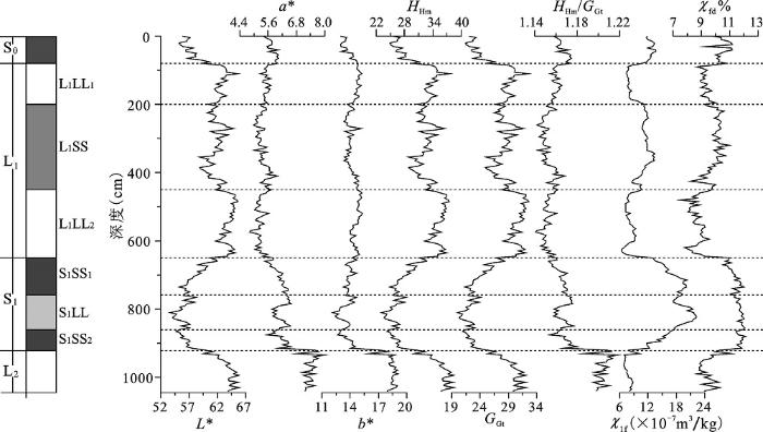
朝那剖面色度指标(L*、a*、b*)和特征光谱(Gt、Hm、HHm/GGt)及磁化率指标(χlf和χfd%)的结果如图2所示。根据地层特征,末次冰期黄土层(L1)分为两层黄土(L1LL1和L1LL2)和一层弱古土壤(L1SS),末次间冰期古土壤层(S1)分为两层弱古土壤(S1SS1和S1SS2)夹一层黄土层(S1LL)。
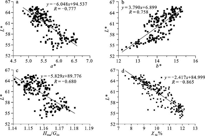
图3说明红度、黄度、赤铁矿与针铁矿的比值以及百分频率磁化率和亮度之间无论是正相关还是负相关,但都有较强的相关性,它们是影响亮度的几个主要因素。亮度L*指土壤的明暗程度,随成壤强度的变化而变化,其主要受土壤的湿度、粗糙度、矿物成分等多种因素影响,a*和b*对L*也有一定程度的影响[31~33]。S1以来剖面L*值的范围为53.68~65.57,平均值为60.53,变化幅度为22.15%。各层L*平均值的大小顺序依次为L1LL2(63.99)>L1LL1(62.88)>L1SS (61.58)> S0(57.27)>S1(57.13)。线性分析L*与a*之间呈明显的负相关(R=-0.777)(图 3a)而与b*呈正相关关系(R=0.758)(图 3b),说明a*、b*的颜色变化是影响L*明亮程度的显著因素之一。
图 2 朝那剖面黄土-古土壤序列及色度、磁化率变化特征
Fig. 2 Loess-paleosol sequence, Colors, Magnetic susceptibility in Chaona section
L*可以反映区域降水量的变化[9,14]。Hm和Gt为土壤和沉积物中的常见矿物,在较高的年平均温度、相对低的年平均降雨量和干湿季分明的水热条件有利于次生Hm形成,而较低的年平均温度、相对高的年均雨量Gt生成较多[8,11,34]。HHm/GGt的大小可以指示气候环境的变化[5],即温度和降水量相对大小的变化。当HHm/GGt减小时,温度降低湿度增加;反之,温度升高湿度减小。L*与HHm/GGt呈负相关(图 3c),但在若古土壤S1SS1阶段L*与HHm/GGt变化趋势相反(图 2),而在其他黄土-古土壤阶段一致性较高,虽然Hm和Gt相对含量较少,但成壤作用强,磁化率高,再加上较高的HHm/GGt,使得L*值小颜色较暗。因此土壤中Hm和Gt的含量以及HHm/GGt是气候环境变化的良好指示。
磁化率强度通常与成壤强度有关,大致反映亚铁磁性矿物总体含量,尤其百分比频率磁化率(χfd%)通常用来指示超顺磁性亚铁磁性矿物的相对含量,进而反映成壤作用的强弱,指示了以气温降水为代表的夏季风强度的变化[35~37]。L*与χfd%之间显著的负相关(R=-0.865)(图3d)说明反映成壤强度对土壤亮度的影响较为显著。L*在黄土-古土壤序列中呈现明显的峰谷交错变化,与磁化率的变化正好相反,与Hm和Gt含量变化较相似,其波动很好地记载气候波动信息。
图 3 朝那剖面L*, a*, b*, HHm/GGt以及百分比频率磁化率之间的相关关系
Fig. 3 Relationship among L*, a*, b* and the ratio of Hm and Gt, and χfd% in Chaona section
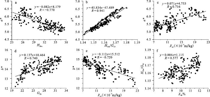
彩度主要包括红度a*和黄度b*。S1以来剖面a*值的范围为4.82~7.59,平均值为5.63,变化幅度为57.47%,各层a*的平均值的大小顺序为S1(6.13)>S0(5.79)>L1LL1(5.51)>L1SS(5.36)>L1LL2(5.26)。b*曲线的波动较a*要小,平均值为14.17,变化幅度为41.33%,各层b*的平均值的大小顺序为L1LL1(14.78)>L1LL2(14.69)> L1SS(14.02)> S1(13.78)> S0(13.77)。a*和b*是致色物质在土壤颜色中的主要表现,在黄土与古土壤中的颜色差异主要受控于铁氧化物尤其是Gt和Hm含量的相对变化。在气候相对干燥、氧化作用较强的条件下磁性矿物氧化形成Hm,从而使土壤呈现红色;而在潮湿的还原环境下容易形成Gt从而使土壤呈现黄色[5,14,28]。通过分析我们发现,a*和HHm负相关明显(R=-0.770)(图 4a),而a*和HHm/GGt之间的正相关很强(R=0.941)(图 4b),说明HHm含量对a*的变化影响很大,温度和水分对a*的影响显著[5,38]。与磁化率对比上,a*与χlf正相关较强(R=0.716)(图 4c),但是曲线对比中(图 2)并不是完全一致的,在S0和L1中,a*与χlf呈现峰谷一致的正相关波动,而在S1中变化趋势相反,主要是因为在干旱温暖的氧化环境下,Hm生成多,成壤作用弱,磁性矿物产生少,故而a*值高,χlf低;潮湿的环境下Hm生成少,成壤作用强,磁性矿物产生多,χlf值高,a*较低。
图 4 朝那剖面a*、b*与特征光谱及其与磁化率的相关关系
Fig. 4 Relationships between a* and b*, Hm, the ratio of Hm and Gt, χlf in Chaona section
同时,b*和GGt之间正相关关系较强(R=0.740)(图4d),说明GGt是b*变化的主要因素之一。同时b*与χlf显著的负相关性(R=-0.720)(图 4e)在S0~S1间有较好的一致性,说明成壤作用强度与b*是此消彼长关系。同时a*、b*以及HHm/GGt很好地指示了末次间冰期古土壤(S1)的发育程度(图 2),在曲线波动的频率和幅度上也较χlf和χfd%好,因此朝那剖面的色度指标能够更好地记录末次间冰期以来的成壤过程和气候演化,而且更为灵敏。
通过对黄土高原朝那剖面末次间冰期以来的色度指标和特征光谱及其与磁化率的对比表明,L*、a*、b*都可以在不同程度上反映气候变化特征。亮度L*与HHm/GGt相关性较好,在S0和L1阶段与HHm/GGt呈正相关,而在S1阶段为负相关。红度a*与HHm/GGt有较强的正相关,反映土壤发育时期的水热条件。黄度b*与针铁矿的相关性较好,与χlf一起使用可以更好地反映土壤的发育程度。相对于磁化率而言,色度指标变化有较高的频率和幅度,能更敏感地反映气候变化特征。
The authors have declared that no competing interests exist.
| [1] |
|
| [2] |
|
| [3] |
Loess stratigraphy in central China [J].https://doi.org/10.1016/0031-0182(89)90143-0 URL 摘要
The low field magnetic susceptibility of loess and soils which reflects the concentration of ultrafine magnetite is related to the degree of pedogenesis and serves as a proxy measure of climate. The accumulation rate of the magnetite was fairly constant throughout the last 1.2 million years and can serve as a measure of time. Susceptibility records from localities near Xifeng and Luochuan, located 160 km apart are compared and used to define informal lithostratigraphic units in the Loess Plateau of China.
|
| [4] |
7-
|
| [5] |
黄土剖面中赤铁矿和针铁矿的定量分析与气候干湿变化研究 [J].https://doi.org/10.3321/j.issn:1001-7410.2007.02.007 URL Magsci [本文引用: 5] 摘要
为了了解黄土剖面中赤铁矿和针铁矿的分布特征,文章采用对铁氧化物矿物灵敏的漫反射光谱法(DRS),开展了赤铁矿和针铁矿的鉴定和测定研究,提出了定量分析赤铁矿和针铁矿含量的DRS新方法.选择天然典型黄土和古土壤样品,首先采用柠檬酸盐-重碳酸盐-连二亚硫酸盐(CBD)方法去除其中成壤成因的铁氧化物矿物,以其为基体配制含不同赤铁矿和针铁矿的系列标样,然后进行DRS测试和多元逐步回归分析,分别建立测定赤铁矿和针铁矿含量的校准方程并加以检验.利用DRS方法,分析了多个黄土剖面的赤铁矿和针铁矿含量,发现黄土-古土壤剖面的赤铁矿/针铁矿比值可作为东亚季风干/湿变化的敏感指标.该比值较高时反映了干燥土壤环境,而较低时指示了潮湿土壤环境.对灵台和洛川剖面中赤铁矿/针铁矿比值的分析,初步揭示了2.6Ma年以来黄土高原东亚季风阶段性变强的特征.
|
| [6] |
西峰蔡家咀黄土剖面记录的末次盛冰期到全新世最佳期气候变化 [J].URL 摘要
采用挖探井方式获取西峰蔡家咀剖面200 cm黄土沉积序列,以7个14C-AMS测年数据为年龄控制点,利用沉积物粒度模式建立最近20 ka的年代框架。磁化率、灰度、粒度等指标的综合对比表明该剖面记录了末次盛冰期增温以来几次重要气候事件,如Heinrich事件1(H1)、Billing-Allerid暖期(B-A)、新仙女木事件(YD)、8.2 ka事件等,说明西峰黄土剖面具有记录短尺度气候突变事件的潜力。
|
| [7] |
黄土高原0.8 Ma以来地面抬升的时空特征研究 [J].Magsci 摘要
<p>根据黄土高原地区黄河阶地的形态特征和成因分析, 认为其形成主要是地面抬升所致并且在黄河达到均衡状态下形成, 可以推断黄土高原的地面抬升。根据对黄土高原地区黄河0.8 Ma阶地的研究并结合相关文献资料, 选取兰州段、黑山峡段、晋陕峡谷段和三门峡段作为典型研究区域, 得出黄土高原0.8 Ma以来的地面抬升存在显著的时空特征, 即空间特征表现为地面抬升量有西大东小的规律, 时间特征表现为地面抬升速率有后期加速趋势、特别是晚更新世以来。并认为黄土高原0.8 Ma以来的地面抬升与青藏高原的构造抬升有成因上的联系。</p>
|
| [8] |
表土颜色和气候定性至半定量关系研究 [J].
通过中国现代土壤的颜色测定, 发现土壤颜色与成土过程和现代气候因子之间有良好的函数关系,土壤红度和黄度主要与赤铁矿和针铁矿的含量密切相关,与气候的关系在热带-暖温带湿润区表现 最好,而明度与有机质积累、腐殖质过程和碳酸盐化过程等密切相关,与气候的关系仅存在于温带湿润-干旱区.土壤的湿度和表面糙度对土壤颜色有较大影响,野 外土壤颜色的直接测定有较大误差.同时,对经典黄土剖面进行的千年尺度和万年尺度颜色气候记录的分析表明,颜色气候记录在这两个尺度上均可很好地再现亚洲 季风和全球气候变化的特征,并表现出了磁化率在相对湿度较高的地区所不能指示出的成土过程和气候特征.
|
| [9] |
陕西洛川黄土剖面的白度参数及其古气候意义 [J].
对陕西洛川黄土剖面的白度研究表明,黄土和古土壤存在明显的白度差别,表现为黄土的白度值较高,而古土壤的白度值较低,依据白度值可以清晰地区另出剖面中的黄土层和古土壤层。化学处理以及分粒级实验结果表明风化成壤作用造成细粒级铁氧化物的含量增高是古土壤中白度值降低的主要因素。洛川剖面白度值的变化与第四纪冰期-间冰期旋回的波动特征相一致,其逐渐增高的趋势与全球气候变冷总体趋势相吻合,表明白度在反映夏季风环流强度变化,以及对全球气候变化的响应问题上具有广泛的应用前景。
|
| [10] |
全新世黄土古土壤序列色度特征及气候意义 [J]. |
| [11] |
靖远黄土-古土壤色度变化特征分析及古气候意义 [J].https://doi.org/10.3969/j.issn.0455-2059.2012.02.003 URL [本文引用: 2] 摘要
对黄土高原西北缘厚层黄土剖面色度指标研究后发现,在磁化率指标不能很好地记录气候变化及土壤发育的情况下,色度指标的引入能够很好地弥补这一古气候重建上的缺陷.在靖远地区,红度a~*主要受土壤中赤铁矿质量分数变化的影响,随赤铁矿的增加而增大,同磁化率联合使用可以反映土壤发育程度,较好地解释气候的变化过程.黄度b~*受到针铁矿质量分数的影响,此外还可能受到黄铁矿、沼铁矿,褐铁矿等铁矿物的影响,在一定程度上可以反映降水量的变化情况.与a~*一同分析,可以反映土壤发育时期的水热条件.亮度L~*主要受土壤中w(TOC),w(CaCO_3)变化的影响,随w(TOC)的增加而减小,而随w(CaCO_3)的增加而增大.此外在CIELAB颜色系统中a~*的增大会显著地使L~*变小,L~*主要反映了土壤发育时期的降水状况以及植被发育程度.在靖远地区,只有综合考虑色度、磁化率、粒度、w(CaCO_3),w(TOC)才能够合理、可靠地重建气候变化的过程.
|
| [12] |
中国黄土颜色变化的控制因素和气候意义 [J]. |
| [13] |
六盘山东麓朝那剖面红粘土年代及其构造意义 [J].https://doi.org/10.3321/j.issn:1001-7410.2000.05.006 URL Magsci [本文引用: 1] 摘要
黄土高原地区黄土之下的红粘土的年代和形成可为六盘山隆起、鄂尔 多斯夷平面解 体以及青藏高原隆升等构造事件提供重要证据。六盘山东麓厚达303m的朝那黄土-红粘土剖面的磁性年代地层学表明:朝那红粘土开始堆积于8.1Ma B.P.,是目前黄土高原上发现的最老的红粘土。8.1Ma B.P.前后一次强烈构造运动使得鄂尔多斯夷平面解体,相对下沉地区接受红粘土沉积,六盘山地区开始隆起,这可能与青藏高原强烈的构造抬升事件有关。
|
| [14] |
1.5 Ma以来黄土高原风尘堆积的岩石磁学记录与中更新世气候转型 [J].
通过对黄土高原中部朝那剖面黄 土-古土壤序列系统的岩石磁学分析,建立了1.5Ma以来黄土高原高分辨率岩石磁学指标演化序列。岩石磁学记录表明本区1.5Ma以来以0.93和 0.62Ma为界经历了3个不同的气候演化阶段。在1.5~0.93和0.62~0Ma期间各种磁学参数大致呈同步变化趋势,能较好地与深海氧同位素 (MIS)曲线相对应,而在0.93~0.62Ma期间(相当于L9底到L6顶,MIS24—MIS16),尽管磁化率、饱和剩磁强度(Mr)、饱和磁化 强度(Ms)与剩磁矫顽力(Bcr)、矫顽力(Bc)曲线的峰谷能与MIS的峰谷相对比,但该阶段的磁学参数变化幅度和形式明显不同于1.5~0.93和 0.6
|
| [15] |
Torii M et al.Late Neogene rock magnetic record of climatic variation from Chinese eolian sediments related to uplift of the Tibetan Plateau [J].https://doi.org/10.1016/j.jseaes.2006.10.004 URL [本文引用: 1] 摘要
The Late Cenozoic red clay-loess sequence in the Chinese Loess Plateau provides a high-resolution record of paleoclimatic and tectonic changes related to the phased uplift of the Tibetan Plateau. Detailed magnetostratigraphy of a recently recovered 125-m-thick sediment sequence from the central Chinese Loess Plateau shows that the red clay began to accumulate at ca. 8.1 Ma, implying a marked drying in the interior of Asian as well as the initial establishment of the East Asian paleomonsoon regime. Prior to 3.8 Ma, the ferromagnetic mineral concentrations, as revealed by both magnetic susceptibility and S-ratios, exhibit a cyclic pattern superimposed upon a linear trend. This pattern collapsed immediately after 3.8 Ma, suggesting a change in source area. This in turn may have resulted from the reorganization of atmospheric circulation and the onset of the modern Asian monsoon, probably associated with the accelerated uplift of the Tibetan Plateau to a certain threshold elevation.
|
| [16] |
King J W et al.Magnetic parameter variations in the Chaona loess/paleosol sequences in the central hinese Loess Plateau,and their significance for the middle Pleistocene climate transition [J]. |
| [17] |
Plio-Quaternary stepwise drying of Asia:Evidence from a 3Ma pollen record from the Chinese Loess Plateau [J].https://doi.org/10.1016/j.epsl.2007.02.029 URL [本文引用: 1] 摘要
A 3-Ma pollen record was obtained from a continuous red clay–loess–paleosol sequence at Chaona in the central Chinese Loess Plateau (CLP). The record shows a permanent change of a domination of typical Cupressaceae forest vegetation representative of an ecological environment with a relative warm and humid climate during 3.0–2.6Ma to largely steppe vegetation under dry climate conditions after 2.6Ma. The later is further manifested itself as steppe to forest or forest–steppe (spruce forest — mostly mesophilous herbs) between 2.6Ma and 1.5Ma, forest–steppe (pine–grass) between 1.5Ma and 0.95Ma, open forest–steppe (mesophilous and xeromorphic herbs–pine) between 0.95Ma and 0.5Ma, and steppe (xeromorphic herbs) after 0.5Ma, suggesting a process of stepwise aridification in Central Asia at the late Pliocene and the Quaternary.
|
| [18] |
Nie J S et al.A preliminary reconstruction of the paleoecological and paleoclimatic history of the Chinese Loess Plateau from the application of biomarkers [J].https://doi.org/10.1016/j.palaeo.2008.10.006 URL [本文引用: 2] 摘要
中国科学院机构知识库(中国科学院机构知识库网格(CAS IR GRID))以发展机构知识能力和知识管理能力为目标,快速实现对本机构知识资产的收集、长期保存、合理传播利用,积极建设对知识内容进行捕获、转化、传播、利用和审计的能力,逐步建设包括知识内容分析、关系分析和能力审计在内的知识服务能力,开展综合知识管理。
|
| [19] |
8.1 M以来朝那黄土-红黏土剖面粒度揭示的冬季风与北半球高纬气候的耦合演化 [J].
通过迄今发现最老的800多万年前的红黏土-黄土高分辨率的粒度分析及其与北大西洋深海氧同位素曲线的对比.揭示亚洲冬季风的演化具有4个明显的阶段.青藏高原在约8,3.6和2.6 MaBP以及其后的阶段性隆升可能是导致亚洲冬季风阶段性演化的驱动力.
|
| [20] |
黄土高原陇东盆地朝那红黏土8.1~2.6 Ma的孢粉记录 [J].https://doi.org/10.1360/03td0235 Magsci [本文引用: 1] 摘要
晚中新世至上新世是当代东亚季风系统和中国西北现代生态环境格局形成演化的关键时期. 文中通过对黄土高原陇东盆地朝那剖面8.1~2.6 Ma期间的孢粉记录研究, 建立了这期间古生态环境序列. 在8.10~6.73 Ma期间, 地带性植被可能是以禾本科为优势种的疏林草原, 在山地有雪松、松等山地针叶林分布, 推测为暖温带半湿润气候. 在6.73~5.67 Ma期间, 植被类型可能是森林草原, 以榆为主, 伴生着栎、柳、胡桃、桦的阔叶杂木林和以禾本科为优势种的禾草草原发育, 反映气候温暖较湿润. 在5.67~3.71 Ma期间, 蒿、禾草草原和松、云杉针叶林发育, 山地气候温凉湿润, 丘陵和低地温暖半干旱. 其中, 在4.61~4.07 Ma期间曾一度温暖较湿润. 在3.71~2.58 Ma期间, 地带性植被可能为柏疏林, 林中混生有榆, 尤其是早先一直存在的反映温暖环境的雪松和铁杉此时消失, 反映环境较前期有较大的改变, 气候季节性明显增强.
|
| [21] |
3 Ma以来黄土高原朝那黄土-红粘土序列赤铁矿记录及其古气候意义 [J].
土壤和前期研究表明黄土-红粘土序列的赤铁矿含量与环境密切相关,对气候的干湿变化非常敏感,气候越湿热,赤铁矿含量越高。本文研究表明黄土-红粘土样品漫反射光谱一阶导数曲线在555~575nm间的峰面积作为赤铁矿指数可以客观有效地指示赤铁矿含量的高低。通过黄土高原朝那剖面红粘土-黄土序列的系统漫反射光谱分析,建立了3Ma以来黄土高原赤铁矿含量变化记录,揭示赤铁矿含量在约2.5Ma,1.5Ma,0.6Ma和0.15Ma显著阶段性减小,指示了黄土高原阶段性变冷干的演化历史。
|
| [22] |
Spectrophotometric color measurement in situ in well drained sandy soils [J].https://doi.org/10.1016/S0016-7061(02)00121-0 URL [本文引用: 1] 摘要
A method for measuring spectral reflectance of samples in place on the face of a soil pit was developed for well drained, sandy soils. Spectrophotometer readings were taken directly on the pit face immediately after scraping a fresh, flat surface to ensure uniform soil moisture content. Measurements taken in this manner were compared to field-based visual estimates and to laboratory-based spectrophotometric measurements of sieved, air-dried samples. While overall reflectance was shown to decrease with increasing moisture content in the laboratory, little change was noted over the 1–7% moisture content range encountered for most samples in the field. The interaction between the “granular materials cover” (a glass window used to protect the integrating sphere) and the “specular reflectance included” viewing geometry resulted in hue shifts for some samples at higher moisture contents, suggesting that the “specular reflectance excluded” mode is more appropriate for in situ measurements of soil samples. A moderately strong correlation exists between spectrophotometer measurements and visual estimates of Munsell parameters in the field, but the spectrophotometer provides a higher degree of precision. Soil features smaller than the 8-mm diameter instrumental measurement area are averaged with the surrounding matrix, however. The research suggests that for well drained, sandy soils, a spectrophotometer can be used in situ to provide reliable, repeatable measurements of spectral reflectance.
|
| [23] |
Paleoceanographic significance of sediment color on western North Atlantic drifts: I. Origin of color [J].https://doi.org/10.1016/S0025-3227(02)00321-3 URL 摘要
Reflectance spectra collected during ODP Leg 172 were used in concert with solid phase iron chemistry, carbonate content, and organic carbon content measurements to evaluate the agents responsible for setting the color in sediments. Factor analysis has proved a valuable and rapid technique to detect the local and regional primary factors that influence sediment color. On the western North Atlantic drifts, sediment color is the result of primary mineralogy as well as diagenetic changes. Sediment lightness is controlled by the carbonate content while the hue is primarily due to the presence of hematite and Fe/Fechanges in clay minerals. Hematite, most likely derived from the Permo-Carboniferous red beds of the Canadian Maritimes, is differentially preserved at various sites due to differences in reductive diagenesis and dilution by other sedimentary components. Various intensities for diagenesis result from changes in organic carbon content, sedimentation rates, and HS production via anaerobic methane oxidation. Iron monosulfides occur extensively at all high sedimentation sites especially in glacial periods suggesting increased high terrigenous flux and/or increased reactive iron flux in glacials.
|
| [24] |
Sediment-color record from the northeast Atlantic reveals patterns of millennial-scale climate variability during the past 500 000 years [J].https://doi.org/10.1006/qres.2001.2289 URL 摘要
A 500,000-yr-long deep-sea sediment-color record from the Northeast Atlantic was investigated to reconstruct the evolution of late Pleistocene climate variability on millennial time scales. Variations of the red-green color intensity are probably caused by climatically induced changes in the ice-rafted input of red-colored iron-bearing terrigenous material to the core site. The resolution of the age model impedes the detection of distinct spectral features at sub-Milankovitch periodicities. Hence, millennial-scale climate variability is quantified as time-dependent variance of the high-pass filtered color time series. The course of the estimated variance shows distinct patterns, which can be linked to continental ice mass. During the past 500,000 yr, large-amplitude millennial-scale climate variability occurs only if continental ice mass exceeds a threshold level, equivalent to sea level at approximately 40% of the lowering during the last glacial maximum.
|
| [25] |
Johnson W C et al. High-resolution proxy record of Holocene climate from a loess section in Southwestern Nebraska, USA [J].https://doi.org/10.1016/j.palaeo.2006.09.004 URL 摘要
L 68 a 68 b 68 color parameters and organic carbon content of Bignell Loess are sensitive proxies to differentiate drought-induced aeolian sediment layers from the intercalated soil horizons. Soil organic carbon-derived δ 13 C data suggest that the C 3 -dominated floral environment during Peoria Loess deposition shifted dramatically to a C 4 -dominated environment during Brady Soil formation in response to a warming trend. Even greater C 4 abundance characterized the late Holocene. High-resolution δ 13 C data support the contention that C 3 vs. C 4 vegetation change in the Holocene reflects ecosystem response to frequent vegetation disturbance under arid conditions. Time series analysis reveals that δ 13 C and color parameters display high frequency variation with periodicities of 103–118years and 103years, respectively. Similar periodicities were also reported in studies of North Dakota lakes, though the physical mechanism responsible is uncertain. Comparison of Bignell Loess color and tropical Pacific sea surface temperatures (SSTs) allows evaluation of a proposed teleconnection between drought in the Great Plains and La Ni09a-like conditions in the tropical Pacific. The loess color index and eastern tropical Pacific SST display broad similarities through the late Pleistocene and Holocene that are consistent with this teleconnection. On the other hand, drought centered at 3800years ago is not consistent with the teleconnection, and the end of early Holocene aridity at the Wauneta section, around 6500years ago, is much earlier than the corresponding rise in SST and increase in El Ni09o frequency in the eastern tropical Pacific.
|
| [26] |
Miralles I et al. Estimating the mass wetness of Spanish arid soils from lightness measurements [J].https://doi.org/10.1016/j.geoderma.2007.07.005 URL 摘要
The colour of a soil changes with its water content. This paper investigates the ability of spectrophotometric colour measurement to predict soil mass wetness ( w ). We looked at the CIELAB parameters ( L 68 , C 68 ab , h ab ) and spectral profile of 76 A soil-horizons from south-eastern Spain to (i) group them by colour, (ii) calibrate within each group the relationships between water content and colour in disturbed and undisturbed samples, and (iii) test the validity of predictive models. Four groups of differently coloured soils were selected from the reflectance curves. Models constructed only with L 68 (lightness) from the dryness state to the water content at 6133/6110kPa explained the greatest variation in w ( R 2 =0.77–0.97), regardless of the soil colour or sample type. The decrease in soil lightness with increasing water content was noted mainly at 611500kPa, 61400/61100kPa, and 6133/6110kPa potentials. At intermediate potentials, however, L 68 did not strongly correlate with w , especially in undisturbed samples, which showed a greater colour variability. Although the predictive models did not give estimates of w with high enough precision (mean relative errors 25.3–56.6%), the measured values below 611500kPa, between 611500 and 61100kPa, and above 61100kPa were predicted within the same interval of water potential. The results indicate that predictions of the dryness condition, presence of plant-available water and wetness near to field capacity, but not the specific water content, can be made with reasonable confidence in any soil by using the models calibrated in other soil of similar colour.
|
| [27] |
Liang L J et al.Changing color of Chinese loess:Geochemical constraint and paleoclimatic significance [J].https://doi.org/10.1016/j.jseaes.2010.08.006 URL Magsci [本文引用: 1] 摘要
Two loess-paleosol sequences on the central Chinese Loess Plateau were investigated to understand spatial and temporal variations in the soil color (e.g., lightness and redness) and factors that control those variations. Color difference between the original samples and pretreated samples suggests that loess lightness is influenced by the pedogenic matter (e.g., iron oxides, organic matter, and calcium carbonate) to varying degrees, depending on the concentrations. Iron oxides and organic matter darken the loess lightness, whereas carbonate lightens the loess lightness. By contrast, the redness is dominantly controlled by the types and concentrations of iron oxides. Variations in magnetic susceptibility and redness are associated with different magnetic minerals that formed mainly during post-depositional processes, and therefore both proxies can be employed to reconstruct the history and variability of the East Asian summer monsoon. Since the sensitivity of these two proxies to the summer monsoon variation is different, we generate a stacked summer monsoon index by combining these two records and interpret the stacked index as most indicative of precipitation variability. The fidelity of this new index is supported by an independent ratio, estimated from the first-derivative values of the color reflectance spectra. Our loess-based proxies provide a new understanding of the East Asian summer monsoon variability as a two-phase strengthening of summer monsoon intensity during the penultimate deglaciation. (C) 2010 Elsevier Ltd. All rights reserved.
|
| [28] |
Electronic spectra of Fe3+ oxides and oxide hydroxides in the near IR to near UV [J]. |
| [29] |
Quantitive analysis of iron oxide concentrations within Aptain-Albian cyclic oceanic red beds in ODP Hole 1049C,North Atlantic [J]. |
| [30] |
Quantification of hematite from the visible diffuse reflectance spectrum: effects of aluminium substitution and grain morphology [J].https://doi.org/10.1180/claymin.2011.046.1.137 URL Magsci [本文引用: 1] 摘要
Hematite exists ubiquitously in soils and sediments, and is commonly aluminium (Al)-substituted. This study investigated systematically the effects of Al substitution on the visible diffuse reflectance spectrum (DRS) of hematite by using several sets of synthetic samples. We found that the position and amplitude of the characteristic absorption band of hematite (estimated from the first-and second-order derivative curves of the Kubelka-Munk remission function spectrum derived from the DRS) was significantly affected by the degree of Al substitution as well as by sample grain morphology. Therefore, there are ambiguities in quantifying the degree of Al substitution and the mass concentration of hematite using DRS. Nevertheless, if hematite forms under similar environmental conditions, it is possible to establish a transfer function between the DRS parameters and hematite concentration as discussed here for a Chinese loess-palaeosol sequence.
|
| [31] |
Mineralogic and Climatic Interpretations of the Luochuan Loess Section (China) based on diffuse reflectance spectrophotometry [J].https://doi.org/10.1006/qres.2001.2238 URL [本文引用: 1] 摘要
We examined the top 135 m, that is, the entire Pleistocene, of the classic Luochuan section on the Chinese Loess Plateau with a diffuse reflectance spectrophotometer from the near ultraviolet, through the visible, and into the near infrared. From the reflectance data we calculated sample brightness which, with some caveats, is a reasonable proxy for magnetic susceptibility. Mineralogic changes were identified by factor analyzing the first derivative of the percent reflectance data and examining samples with high factor scores. Two factors which explain about 96% of the cumulative variance are distinguished by the relative proportion of hematite and goethite, the minerals that are responsible for the color changes in the loess sequence. Both hematite and goethite are present in both loess and paleosol but goethite dominates in loess whereas hematite dominates in paleosol. The goethite factor exhibits an inverse correlation with magnetic susceptibility; the hematite factor exhibits a weak positive correlation with susceptibility. Paleoclimatic interpretations are drawn from comparison of susceptibility to the concentration of spectrally identified hematite. Based on this comparison, paleosols in the early Pleistocene Wucheng Formation are characterized by conditions that are drier than today, a 'dry summer monsoon', whereas later Pleistocene paleosols are characterized by a 'wet summer monsoon'.
|
| [32] |
Balsam W et al.Characterization of the Chinese loess-paleosol stratigraphy by whiteness measurement [J].https://doi.org/10.1016/S0031-0182(02)00246-8 URL 摘要
Changing color is one of the most striking features of loess–paleosol sequences in central China: the loess is light yellow and the interstratified paleosols are reddish-brown. Until a few years ago, conventional color description of loess sediments was made using a qualitative visual method, the Munsell system. To better understand the character of the color changes and to quantify results, whiteness and magnetic susceptibility were compared from four loess–paleosol sequences. Results show that the two parameters are highly correlated in the four sequences studied. Grain-size analysis and chemical extraction experiments indicate that the concentration and species of fine-grained iron oxides are major factors determining color changes in loess and paleosols. Whiteness and latitude values from the last glacial–interglacial sequence exhibit a linear relationship suggesting that whiteness will be a useful tool for reconstructing past atmospheric circulation, especially the East Asian summer monsoon. Whiteness and magnetic susceptibility in the Luochuan profile over the past 0.9 Myr display a strong correlation indicating that whiteness can be also used to reveal a long climatic history from Chinese loess–paleosol sequences.
|
| [33] |
Color reflectance of Chinese loess and its implications for climate gradient changes during the last two glacial-interglacial cycles [J].https://doi.org/10.1029/2003GL018346 URL [本文引用: 1] 摘要
To examine the relationship between color changes of loess deposits and paleoclimate conditions, a north-south transect consisting of twelve loess sections were studied. Color reflectance was measured on loess-paleosol samples from the loess transect which accumulated over the last two glacial-interglacial cycles. The redness value, a*, shows an overall southward increase for both loess and soil units, coinciding with the pattern of a southerly increase in pedogenic development and the present north-south climatic gradient. The redness of loess deposits is linearly correlated with latitude values, implying that this parameter is an efficient proxy for the weathering intensity of loess deposits. The gradient of weathering intensity is much steeper during interglacials than in glacials, by comparison of color records for different time interval.
|
| [34] |
南方红土的磁性矿物组成及其区域性差异 [J].https://doi.org/10.3969/j.issn.1001-7410.2012.04.07 URL Magsci [本文引用: 1] 摘要
位于我国热带、亚热带地区的南方红土是我国分布最广的第四纪土状沉积,其经历了较强的化学风化作用,具有典型的磁性矿物组成。磁性矿物是沉积物的重要组成成分。磁性矿物的种类、粒度和含量等信息可以反映沉积物形成时的温度、降水等气候条件。因此,了解红土沉积物磁性矿物组成对于研究南方红土区的环境演化具有重要意义。本文综合分析了安徽宣城、浙江长兴、江西九江及广西百色4个剖面不同层位红土样品的x-T曲线、三轴等温剩磁热退磁曲线等岩石磁学结果,发现南方红土的磁性矿物组成主要为磁铁矿、磁赤铁矿、赤铁矿及针铁矿,这些磁性矿物的相对含量不仅具有地带性差异,而且在不同风化阶段也存在差异。其中百色剖面顶部棕色土中磁赤铁矿含量相对其他剖面较高,与百色地区现今较强的风化作用相符。同一剖面内网纹红土中赤铁矿的含量较高,磁赤铁矿的含量相对较低,指示网纹化时期较强的成土作用引起磁赤铁矿向赤铁矿的转化。此外,岩石磁学结果显示百色剖面网纹红土及均质红土中含有一种特殊性质的磁性矿物,即粒度较细、解阻温度较低的成土成因赤铁矿,该矿物为后期强烈风化作用的产物。该次生矿物携带了较强的化学剩磁,引起了百色剖面初始碎屑剩磁的重磁化。该研究表明磁性矿物组成的差异还可以用来解释南方红土剩磁记录的多样性。
|
| [35] |
Magnetic susceptibility evidence of monsoon variation on the Loess Plateau of Central China during the last 130 000 years [J].https://doi.org/10.1016/0033-5894(91)90015-W URL [本文引用: 1] 摘要
国际
|
| [36] |
Magnetic mineralogy of Chinese loess and its significance [J].https://doi.org/10.1111/j.1365-246X.1992.tb00859.x URL 摘要
Not Available
|
| [37] |
The history and variability of the East Asian paleomonsoon climate [J].https://doi.org/10.1016/S0277-3791(99)00060-8 URL [本文引用: 1] 摘要
Changes in the East Asian paleomonsoon reflect interactions between the global atmosphere, ocean, land and ice systems, and are also an expression of their combined effect within the boundary conditions imposed by the East Asian continent and solar radiation. The history of the East Asian monsoon is an alternation between dominance by the dry-cold winter and warm-humid summer monsoons. High-resolution eolian sequences preserved in the Chinese Loess Plateau reveal that the East Asian monsoon may have commenced at least 7.2 Ma ago. They also provide evidence indicating that the pulsed uplift of the Tibetan Plateau at about 3.4 and 7.2 Ma may have played an important role in inducing climate change. The palaeoclimatic records of the last glacial cycle show high-frequency variability on time scales of 1000-year or even shorter, and instability of the East Asian paleomonsoon system. The high-frequency variability could be due to a non-linear response to orbital forcing, or a result of the coupling processes between different components of the global system. Cold air activity in northern high latitudes, the trans-equatorial air streams from the Southern Hemisphere and, possibly, ENSO may have played an important role in East Asian monsoon variability. The synchroneity of all the palaeoclimatic events along the polar-equator-polar (PEP) transect is still an open question. Correlation of limited palaeoclimatic records for the last 30 kyr obtained from East Asia and Australia suggests that the trans-equatorial air streams driven by the monsoon and trade winds may have had an influence on opposite hemispheres.
|
| [38] |
Mineralogic and Climatic Interpretations of the Luochuan Loess Section(China) Based on Diffuse Reflectance Spectrophotometry [J].https://doi.org/10.1006/qres.2001.2238 URL [本文引用: 1] 摘要
We examined the top 135 m, that is, the entire Pleistocene, of the classic Luochuan section on the Chinese Loess Plateau with a diffuse reflectance spectrophotometer from the near ultraviolet, through the visible, and into the near infrared. From the reflectance data we calculated sample brightness which, with some caveats, is a reasonable proxy for magnetic susceptibility. Mineralogic changes were identified by factor analyzing the first derivative of the percent reflectance data and examining samples with high factor scores. Two factors which explain about 96% of the cumulative variance are distinguished by the relative proportion of hematite and goethite, the minerals that are responsible for the color changes in the loess sequence. Both hematite and goethite are present in both loess and paleosol but goethite dominates in loess whereas hematite dominates in paleosol. The goethite factor exhibits an inverse correlation with magnetic susceptibility; the hematite factor exhibits a weak positive correlation with susceptibility. Paleoclimatic interpretations are drawn from comparison of susceptibility to the concentration of spectrally identified hematite. Based on this comparison, paleosols in the early Pleistocene Wucheng Formation are characterized by conditions that are drier than today, a 'dry summer monsoon', whereas later Pleistocene paleosols are characterized by a 'wet summer monsoon'.
|

/
| 〈 |
|
〉 |