潘志新 , 彭华
, 彭华
中山大学地理科学与规划学院,广东 广州 510275
PAN Zhi-xin, PENG Hua
中图分类号: P931
文献标识码: A
文章编号: 1000-0690(2015)12-1575-10
通讯作者:
收稿日期: 2014-11-16
修回日期: 2015-03-19
网络出版日期: 2015-01-20
版权声明: 2015 《地理科学》编辑部 本文是开放获取期刊文献,在以下情况下可以自由使用:学术研究、学术交流、科研教学等,但不允许用于商业目的.
基金资助:
作者简介:
作者简介:潘志新 (1986-),男,江西省婺源县人,博士研究生,研究方向为丹霞地貌及资源环境管理。E-mail:panzhix@mail2.sysu.edu.cn
展开
摘要
为了解全球红层的时空分布规律及其地貌发育的差异,对国内外红层的分布、形成年代、地质构造背景、古地理环境、岩性和地貌特征等进行了对比研究。结果表明:国内红层主要分布于东南、西南、西北等地区,形成年代主要为中生代,尤以白垩纪为主,构造环境主要为古陆块活化时形成的断陷/拗陷盆地;沉积环境几乎全部为陆相,形成于干旱或半干旱古气候条件;岩性复杂,兼具砾岩、砂岩、粉砂岩和泥岩,发育了丹霞地貌、红层高原、红层山地和红层丘陵等多种地貌类型。国外红层的形成年代跨度很大,从前寒武纪到新近纪均有发育,呈现出从老陆块向新陆块扩展的趋势;构造环境分为山前/山间拗陷堆积、地台拗陷堆积、裂谷盆地堆积和弧后盆地堆积;沉积环境以陆相为主,兼具滨-浅海相和海陆过渡相,也形成于干旱、半干旱气候;岩性以砂岩、粉砂岩和泥岩为主,砾岩较少;发育的地貌类型相对单一。
关键词:
Abstract
In order to advance our understanding on the temporal and spatial distribution law of red beds in the world and their differences in geomorphic development, a comparative study was conducted on the distribution, age, geological setting, paleogeographic environment, lithology, and geomorphic features of red beds in and outside China. It reveals that red beds in China are mainly distributed in southeast, southwest, and northwest China. They were mainly deposited in the Mesozoic Era, especially in Cretaceous. The major tectonic settings for the deposition of red beds in China are fault basins and depression basins in reactivated areas of paleo-landmass. Almost all red beds in China are continental deposits, which were formed in arid and semi-arid paleoclimate conditions, with a wide range of grain size, from coarse-grained conglomerates,through fine-grained sandstones and siltstones to mudstones. Various types of landform were developed on red beds in China, including Danxia landforms, red bed plateaus, red bed mountains, and red bed hills. By contrast, red beds outside China have a much wider range of age, from Precambrian to Neogene, indicating a trend of deposition from old landmass to young landmass. As for tectonic setting, it can be classified into four types: piedmont/intermountain depression deposition, platform depression deposition, rift basin deposition and back-arc basins. Most of them were continental deposits, with few littoral and transitional facies. The paleoclimate for the formation of these red beds was also arid and semi-arid climate. However, in lithology, most red beds outside China were composed of red sandstones, siltstones, and mudstones, with few coarse-grained deposits like conglomerates. Except in some piedmont/intermountain basins with complex tectonic setting, the types of red bed landforms developed in stable landmassesoutside China are relatively simple.
Keywords:
红层是形成丹霞地貌的物质基础[1]。但长期以来,国内外对红层及其地貌发育的研究一直比较薄弱。现有研究中,地质学界大多围绕某个区域红层中的岩石矿物、古地磁、古生物来展开,推演红层颜色的成因及其沉积时的地质构造背景和古地理环境特征;地貌学界则多集中在红色砾岩或砂砾岩形成的丹霞地貌,对其它岩性红层的地貌发育过程缺乏关注[2]。而在红层分布方面,虽然有部分国内学者对中国的红层分布特征及其地貌发育类型进行了总结,如:20世纪70年代,曾昭璇等总结了中国东南部的红层分布及其地貌发育条件[3];李廷勇等划分了中国红层主要分布区域及其发育的地貌类型[4],但是国外红层却很少有人提及。更鲜有人从全球的角度出发,对国外红层的分布、形成年代、沉积环境、岩性特征和地貌发育等进行系统梳理,并与中国的红层进行对比。
近年来,由于“中国丹霞”申遗成功和“国际地貌学家协会红层和丹霞地貌工作组(IAG Red Beds and Danxia Geomorphology Working Group)”的推动,启动全球红层和丹霞地貌调查,开展国际对比研究开始被提上议程。在对相关研究成果进行整理的基础上,本文从红层的分布、形成年代、地质构造背景、古地理环境、岩性和地貌特征等方面对国内外红层及其地貌发育进行初步对比分析,总结全球红层的时空分布规律及其地貌发育的差异。一方面为国内同行了解国外红层提供参考;另一方面也为接下来开展国内外典型红层分布区红层地貌发育的对比研究提供理论依据。
国内研究表明,中国红层主要为红色陆相碎屑沉积[3,4]。据郭永春等统计,全国红层总面积约8.26×10⁵km2,占陆地总面积的8.61%[5],广泛分布于大陆各省(自治区、直辖市),但集中在东南、西南和西北[1]。形成年代上,中国红层多不早于中生代,尤以白垩纪为主[4, 6]。不过,在塔里木盆地南缘、甘肃和山西等地区也发现有少量泥盆纪和二叠纪的老红层出露[6]。
具体而言,东南地区的红层多散布于北东-北北东向的中小型山间盆地,形成年代多为白垩纪,局部为古近纪,以河湖相和冲积扇相为主。西南地区的红层主要分布在四川盆地和滇中、滇西地区,形成年代以侏罗纪和白垩纪为主,多为古川滇湖区的河湖相沉积[6]。西北地区的红层主要出露在鄂尔多斯、塔里木、准噶尔等盆地的边缘,形成年代跨度较大,从晚古生代至新近纪均有。此外,青藏高原亦有大量白垩纪-新近纪红层分布,以冈底斯山脉北侧及青海东部最为集中;东北和华北平原也有白垩纪红层分布,但除了盆地边缘外,这里的红层多被第四纪沉积物所覆盖[1]。
中生代的印支运动和燕山运动,以及新生代的喜马拉雅运动对中国构造格局的形成和气候环境的演变影响巨大,是红层形成的主要阶段。
中生代以前,中国范围内的古陆尚未拼接完成,陆地面积较小且分散。出露面积较大的华北古陆处于中纬度湿润气候区,很少有红层堆积;而南方大部分地区此时为海洋环境,缺少陆相沉积。到三叠纪中、晚期,印支运动使南方许多地区隆起成陆,并与北方古陆连为一体,陆地面积扩大。侏罗纪时,中国基本结束了“南海北陆”的格局,形成了宽广的大陆沉积环境[4]。中、晚侏罗世时,受古秦岭-古祁连山-古昆仑山脉和川黔贵高地的影响,中国内陆地区由温暖湿润气候转向亚热带干旱-半干旱气候[7],许多内陆盆地开始接受红色碎屑堆积,如四川盆地和鄂尔多斯盆地。
晚侏罗世至白垩纪期间,受燕山运动影响,中国大部分古陆块强烈活化,构造格局由原来的南北分异转为东西分异。西部地区构造继承性突出,四川盆地、鄂尔多斯、塔里木等大型稳定的内陆盆地继续接受河、湖相沉积;东部地区因受到太平洋板块的俯冲挤压,形成一系列北东或北北东向斜列的褶皱断裂山地和大量中小型断陷盆地[8]。白垩纪时,受东部隆起带的影响,来自海洋的水汽难以进入,华北、华南和中南等广大地区均处于干旱气候环境[9],成为红层最为发育的阶段。
进入新生代后,受喜马拉雅运动的影响,特提斯古海槽逐渐闭合,青藏高原开始隆起。同时,中国中东部干湿交替的季风气候特征逐步形成,由此前的干旱环境转为湿润环境。到古近纪末,该地区的红层沉积基本结束,而西北地区在此期间气候变得更为干旱[10, 11],几个大型内陆盆地及青藏高原地区继续接受红色碎屑堆积,发育了大量古近纪和新近纪红层[1]。
中国红层几乎全部为陆相碎屑沉积,岩性构成复杂,既有砾岩,也有砂岩、粉砂岩和泥岩,有些还含淡水灰岩、石膏等蒸发岩夹层[12]。从矿物组成上看,红层的主要碎屑物质为石英和长石,胶结物为铁质、钙质、硅质或泥质。一般来说,大型红层盆地的沉积分异现象明显,盆地边缘多为洪积相的砾岩和角砾岩,它们往往为硅质、铁质胶结,岩石比较坚硬;而往盆地中心,沉积物粒度逐渐变小,多为河流相和湖泊相的细砂、粉砂和泥岩,为粘土或铁、钙质胶结,岩性比较软弱。
由于各地红层岩性的差异,在不同的地质构造和气候条件影响下,中国红层区广泛发育了高原、丘陵、台地、山地等多种地貌类型。其中,最为典型的是以红色陡崖坡为特征的丹霞地貌。丹霞地貌在中国广泛分布,并且由于内、外动力作用的差异,呈现出明显的地域分异[13, 14]。东南地区气候湿润,流水对丹霞地貌形态的塑造作用显著,多发育丹霞峰林、峰丛景观;西南地区受新构造运动影响强烈,红层盆地抬升量较大,多形成高原-峡谷型或高原-山地型丹霞景观。相比之下,西北地区的丹霞地貌特征较为复杂。一方面,西北地区构造运动强烈,许多红层产状为陡倾斜甚至直立状态,形成尖顶的丹霞地貌;另一方面,西北地区气候干旱,流水侵蚀作用相对较弱,泥质和粉砂质红层也可形成丹霞陡坡。
作为红层区重要的地貌类型,丹霞地貌因其突出的景观价值而备受国内地貌学界的关注。不过,丹霞地貌只是红层区发育的一种地貌类型,有红层的地区不一定都发育丹霞地貌。通常形成丹霞地貌的都是岩性较坚硬的砾岩和砂岩,多集中在断裂抬升强烈的盆地边缘区;而在大型红层盆地内部,由于构造运动影响较小,加之软弱的泥岩易被风化侵蚀,一般只形成和缓的红层丘陵。
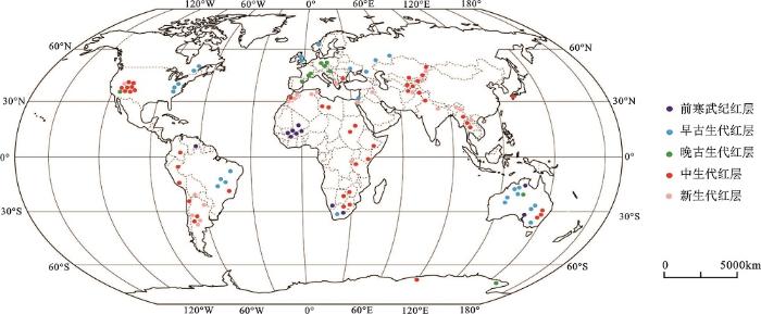
根据目前掌握的资料,红层遍布全球各大洲。国外主要红层分布区及特征介绍如下(图1):
1) 亚洲。中国之外的其它亚洲国家也有很多红层分布,它们绝大多数为陆相沉积,且形成年代较新,以白垩纪和古近纪为主。东亚地区的红层有日本九州岛中西部Goshonoura盆地的Goshonoura群,该红层为河口-浅海相,形成于白垩纪中期,岩性兼具砾岩、砂岩和泥岩[15]。东南亚泰国半岛Trang盆地出露有中、晚侏罗世到晚白垩世的红层-Trang群,岩性以砂岩为主[16]。南亚地区,巴基斯坦北部东兴都库什山脉的Shishi谷地有白垩纪红层Purit组出露,由河流相砾岩和砂岩组成,含钙质夹层[17];印度西北部的Kangra和Subathu地区等喜马拉雅山山前盆地中堆积有古近纪的Dagshai组红层,它由河流相砂岩、粉砂岩和泥岩组成,也含钙质夹层[18]。中亚地区,阿富汗著名的巴米扬大佛所在地——巴米扬谷地还出露有中新世红层,以砾岩和粉砂岩为主[19]。西亚地区的红层有伊拉克东北部的Gercus组,埃及西奈半岛Abu Zenima地区的Taybi组,它们都为古近纪红色陆相粗碎屑沉积,局部地区过渡到海相的红色粉砂岩[20]。此外,约旦西南部的佩特拉(Petra)是亚洲少有的老红层代表,其沉积于寒武纪,辫状河流相沉积的Umm Ishrin组厚度约500 m,是形成佩特拉古城红色砂岩崖壁的地层[21, 22]。
2) 欧洲。欧洲大陆的红层主要分布在比利牛斯山、阿尔卑斯山、喀尔巴阡山等山脉两侧的山前盆地,沉积年代以古生代和中生代为主。如西班牙东北部比利牛斯山南侧中部Erill Castell盆地的Lower Red组[23];和东南部阿尔卑斯山西侧Dôme de Barrot盆地的Daluis组和Léouvé组[24];以及奥地利境内阿尔卑斯山北侧Tyrol东部的Gröden组[25]。这些红层都形成于二叠纪,以河流相沉积为主,含火山碎屑岩和钙质夹层。东喀尔巴阡山脉南段罗马尼亚境内还堆积了大量晚白垩世红层,以浅海相的红色页岩、粘土岩为主,如GuraBeliei组[26]。
此外,在英国苏格兰地区的Midland谷地和威尔士地区的Anglo-Welsh盆地[27];挪威西部的Hornelen地区[28];乌克兰西部的Podolia地区[29]等还广泛分布着志留纪-泥盆纪的老红砂岩(Old Red Sandstone)。这些老红砂岩多为洪积相和河流相沉积,属加里东造山期的磨拉石建造。
3) 北美洲。北美红层主要分布于美国西部的科罗拉多高原,形成年代为石炭纪-古近纪,但以三叠-侏罗纪为主,沉积环境多为陆相,兼有少数滨-浅海相。如出露于大峡谷国家公园的石炭纪Supai群[30]和早二叠世的Hermit组[31],它们沉积于宽广的滨海平原环境,岩性为红色粉砂岩、泥岩和页岩,上下都有与石灰岩层的不整合面。三叠-侏罗纪的红层主要有早三叠世的Moenkopi组[32],晚三叠世的Chinle组[33],早侏罗世的Moenave组[34]、Wingate Sandstone组[35]和Kayenta组[36],早-中侏罗世的Navajo Sandstone组[37],以及中侏罗世晚期的Entrada Sandstone组[38]。古近纪的红层主要是布莱斯峡谷国家公园出露的Claron组,形成于始新世[39]。这些红层形成于河流、湖泊或沙漠环境,岩性多为红色细砂岩、粉砂岩、泥岩。其中,特别值得一提的是Navajo Sandstone组,它保存有世界上最大规模的风成交错层理,最大厚度达670 m[40]。
除科罗拉多高原外,北美东北部沿阿巴拉契亚山脉到纽芬兰岛和拉布拉多半岛地区还有老红砂岩分布,如晚志留世的Bloomsburg组[41]和中-晚泥盆世的Catskill组[42],它们和西欧的老红砂岩相对应,都为加里东运动时形成的红色碎屑堆积,以河流相砂岩和页岩为主。
4) 南美洲。南美洲的红层主要分布于安第斯山脉两侧的山前盆地和稳定的内陆克拉通盆地。如智利Salar de Atacama 盆地堆积的Purilactis群,它沉积于白垩纪至古近纪,由红色砂岩、泥岩、砾岩和蒸发岩组成,夹少量火山岩,总厚度约6 000 m[43];玻利维亚的Altiplano高原和东科迪勒拉地区堆积有大量古新世红层,如Santa Lucia组,它为河流相和湖泊相沉积,以砂岩、粉砂岩为主,夹砾岩透镜体[44]。阿根廷的Cafayate国家公园和Talampaya国家公园也有红层出露,前者主要是Salta群,形成于白垩纪至古近纪,主要为红色砾岩、砂岩和页岩,最大厚度约4 000 m[45];后者为早三叠世的PaganzoⅢ群,以红色砂岩为主[46]。
稳定克拉通盆地的红层堆积主要有巴西南部Bauru盆地的Rio Paraná组,该组红层形成于晚白垩世,由红色、棕红色细粒-中粒石英砂岩组成,具风沙沉积特征,板状斜层理非常发育,平均厚度为45 m,最大可达300 m[47];巴西东北部Piauí州的Serra da Capivara国家公园沉积了志留纪-泥盆纪的红层Serra Grande群和Canindé群,它们形成于河流和三角洲环境,以褐色砂岩为主[48]。此外,委内瑞拉东南部Bolívar州的Canaima国家公园还沉积有前寒武纪的红层-Roraima超群。该地区为冈瓦纳古陆圭亚那地盾的一部分,红层最大厚度约3000m,主要为河流相和湖泊相,形成了世界上最为壮观的桌状山[49]。
5) 非洲。非洲的红层主要分布在东非大裂谷、北非阿特拉斯山脉的裂谷盆地及稳定的内陆克拉通盆地。其中,坦桑尼亚西南部和马拉维北部的Rukwa和Malawi裂陷盆地出露的红层有Red Sandstone群,它为中粒红色砂岩,夹砾石或泥岩透镜体,形成于白垩纪至古近纪[50];北非摩洛哥的高阿特拉斯山(High Altas)西部的Argana谷地沉积了厚达2 500~5 000 m的红层,代表了三叠纪至早侏罗世期间北美大陆和非洲板块分离时的裂谷沉积[51, 52];非洲稳定的内陆盆地地区还堆积了前寒武纪老红层,如南非Kaapvaal克拉通的Wilgerivier组[53],它以砂岩为主,夹少量砾岩和泥岩。此外,马里的Taoudeni盆地还出露有前寒武纪-奥陶纪的红色砂岩——Bandiagara组,其产状水平,经抬升侵蚀后形成了大面积的红层高原、桌状山及绵延数百千米的崖壁[54, 55]。
6) 澳大利亚。澳大利亚大陆是南方冈瓦纳古陆的一部分,沉积的红层年代古老,多为元古代和古生代,主要分布在北领地和西澳大利亚州。其中,北领地北部Kakadu国家公园出露有前寒武纪红层-Kombolgie子群,它由多组砂岩组成,兼具河流相和浅海相[56];北领地南部Uluru-Kata Tjuta国家公园的Ayers Rock和Mount Olga,它们分别由寒武纪早期冲积扇相的长石砂岩Mutitjulu Arkose组和Mount Currie砾岩组成[57]。西澳大利亚州的红层主要分布在Kimberley地区,如Purnululu国家公园的Bungle Bungle Range,该处红层为泥盆纪的Grass Hill组,形成了密集的锥状砂岩峰丛景观[58]。
7) 南极洲。据文献显示,南极洲亦有红层分布,如维多利亚地南部的晚泥盆世Aztec组和查尔斯王子山北部的Beaver湖区附近早-中三叠世的Flagstone Bench组。前者形成于河漫滩平原环境,主要由粉砂岩和泥岩组成[59];后者也为粉砂岩和泥岩,且具龟裂填充构造,反映了由湿润向半干旱转换的沉积环境[60]。总体上,由于南极洲绝大部分地区被冰川覆盖,目前对南极洲红层的研究还很有限,难以确切说明其分布及特点。
从构造环境来看,国外红层堆积可归为以下4种类型:
1) 造山运动同时或之后的山前/山间拗陷堆积:如美国阿巴拉契亚山地区、西欧和北欧的志留纪-泥盆纪的老红砂岩形成于加里东运动期间;欧洲西南部的红层堆积于老阿尔卑斯运动期间;南美的智利、阿根廷、玻利维亚等地的红层形成于新阿尔卑斯运动期间;中亚和南亚的红层则属于喜马拉雅运动时印度板块和欧亚板块碰撞的缝合线前缘堆积。
2) 地台拗陷堆积:一般是在成陆较早的克拉通盆地。如委内瑞拉东南部、南非、马里和澳大利亚中北部地区的前寒武纪-寒武纪红层等都形成于冈瓦纳古陆内部稳定的克拉通盆地。
3) 裂谷盆地堆积:这类红层堆积与大陆裂解分离过程中局部地壳下沉有关,如东非的坦桑尼亚和马拉维,埃及西奈半岛的红层等都是东非大裂谷形成时的堆积;北非的摩洛哥和巴西南部的红层则代表了冈瓦纳古陆分离时的裂谷沉积。
4) 弧后盆地堆积:指由于大洋板块向大陆板块俯冲,弧后大陆岩石圈地幔物质上拱和陆壳微型扩张而形成的拉张型盆地,在下部岩浆源减少或冷却过程中盆地下沉接受堆积。如美国科罗拉多高原堆积的中生代红层。
总体而言,除地台拗陷沉积外,国外红层多形成于构造运动比较活跃的时期。一方面构造活跃期是地壳升降运动强烈的时期,有盆地沉积空间和山地物源;另一方面构造活跃期的地温梯度较大,有利于铁的氧化[61]。此外,板块的移动将一些陆块推移到热带或亚热带地区,也有利于沉积物中铁的氧化和红层发育。
沉积环境方面,国外红层大多数为陆相沉积,兼有部分滨-浅海相和海陆过渡相。其中,滨-浅海相和海陆过渡相的红层主要分布在古大陆板块的边缘地区。如晚古生代时,美国西部处于北美大陆架边缘海区,经常受海侵和海退的影响,在此期间沉积的Supai群和Hermit组,以及Moenkopi组都含有石灰岩夹层,且其红色粉砂岩和页岩段表面具有波痕和泥裂构造,表明其沉积于潮滩或滨海平原环境[30~32]。陆相红层方面,有河流、湖泊、风沙等多种沉积相,特别是风沙沉积,它们的典型特征是具有大规模的交错层理(图2A)。如前述美国科罗拉多高原地区早-中侏罗世的Navajo Sandstone组,规模的形成于宽广的沙漠环境[40]。
气候环境方面,国外红层也基本形成于干旱、半干旱气候。晚古生代和中生代期间,全球大陆板块经历拼合与分离两大过程,气候也相应地产生变化。晚古生代末期,全球大陆板块汇聚形成泛大陆,北方的劳亚古陆西部(北美-欧洲古陆)位于南北纬30°之间,大陆性气候很强,有利于红层的发育。此时的东亚地区古陆块尚未拼接完成,且处于中纬度湿润地区,而南方的冈瓦纳古陆处于第二次大冰期,不具备红层发育的条件。进入中生代后,泛大陆开始解体分离,并伴有强烈的陆缘造山运动。侏罗纪和白垩纪期间,许多大陆边缘褶皱带相继隆起,阻止海洋湿润气流进入,在内陆山间盆地形成干旱、半干旱气候,使北美西部、欧洲中南部、印度北部、非洲北部、南美等地都广泛发育红层,中生代成为全球红层最为发育的时期。
红层地貌的发育受岩性、构造和气候等因素的影响。从岩性因素看,国外目前保存和出露的红层总体以砂岩、粉砂岩和泥岩为主,砾岩等粗碎屑岩较少,只在盆地边缘或小型的山前和山间盆地偶有出露,或只是作为夹层的短期堆积。由于古沉积环境的变化,很多红层的上覆、下伏或夹层为石灰岩、灰绿色泥岩、甚至是火山岩。在红层地貌发育过程中,强度较低的泥岩容易被风化侵蚀,多形成缓丘或缓坡,而强度较大的砂岩则形成崖壁或陡坎。在同一红层剖面,如果多个软硬程度不一的岩层组交替出现,则往往形成多级层位的侵蚀面,如美国犹他州Zion国家公园的Zion峡谷两侧,风成相的Navajo Sandstone组厚度最大,形成大崖壁,其顶部的Temple Cap组White Throne段、下部Kayenta组的Lamb Point Tongue段和Springdale段由细砂-粉砂岩组成,但因厚度较小,只发育成陡坎;而含泥岩层的Temple Cap组Sinawava段、Kayenta组Tenney Canyon Tongue段和Main body段、以及Moenave组则形成侵蚀缓坡(图2B)。
从构造因素看,红层盆地在抬升过程中形成的断层等对其地貌坡面具有控制作用。如美国犹他州Capitol Reef国家公园受南北走向,向东倾斜的Water pocket断层控制,形成了单斜构造,断层西侧的红层岩性组被抬升了2 100 m,发育了连续的陡崖,而东侧沿断层走向只形成了缓坡[62]。
从气候因素看,国外红层分布区大多为干旱、半干旱气候,降水量少且季节分配不均。一方面,干旱的气候有利于红层景观的保持,使很多岩性并不那么坚硬的红层也能形成陡崖坡;另一方面,短期的暴雨洪流沿节理裂隙对红层进行切割侵蚀,形成了众多的峡谷、巷谷和悬谷等景观。
总体而言,国外稳定陆块上的红层发育的地貌类型相对单一,以红层高原、峡谷、侵蚀台地为主;但部分构造复杂的山前/山间盆地发育的红层地貌形态相对复杂多样,既有块状山崖、峰林、峰丛、单面山;也有孤峰、石柱、岛山等。
从上述介绍可看出,国外红层的形成年代跨度很大,从前寒武纪到新近纪均有发育。大体上可分为前寒武纪、早古生代、晚古生代、中-新生代4阶段。其中,前寒武纪红层主要分布在古老陆块的克拉通盆地,如委内瑞拉东南部、西非的马里和澳大利亚西北部;早古生代红层主要分布在北美-欧洲古陆缝合带的山前(山间)拗陷盆地,如美国东北部、北欧、东欧及英国的苏格兰、威尔士等地,以老红砂岩为代表;晚古生代红层主要分布在美国西部和欧洲西南部;中生代红层分布最广,各大洲均有分布(见图1)。
图2 美国犹他州Zion国家公园Navajo 砂岩的风成交错层理(A)和出露的不同岩性红层剖面(B)
Fig.2 Cross beddings of Navajo Sandstone in Zion Nation Park, Utah, USA (A) and exposed stratigraphic profile of different red bed strata (B)
相比之下,中国的红层较年轻,大规模的红层堆积集中在中生代,尤其是白垩纪。这是因为中国大陆板块是由许多小板块逐步拼接而成的。中生代以前,中国板块大部分地区处于海面以下,缺乏大型的古陆或内陆盆地,以及红层发育所需的相对干热的气候条件。直到侏罗纪,中国境内的古陆块大部分拼接完成后,形成足够大的陆地面积并在后期的地壳运动中活化,形成众多中小型山间盆地。白垩纪期间,中国大部分地区处于热带和亚热带的干旱、半干旱气候环境,也为大规模的红层堆积创造了条件。
据此,可将全球红层的时空分布规律总结如下:一,全球红层的沉积呈现出从老陆块向新陆块扩展的趋势,即从古老的冈瓦纳古陆向北美-欧洲古陆和中国古陆扩展;二,红层分布范围逐步扩大,即随着地球陆地面积的扩大,新红层的分布范围大于老红层;三,在全球地壳演化和红层发育的大序列中,中国板块大规模的红层堆积出现最晚,反映了中国作为亚欧大陆的一部分最晚拼合成完整大陆块的地壳演化历史。
构造环境上,国外红层可归为山前/山间拗陷/断陷堆积、地台拗陷堆积、裂谷盆地堆积和弧后盆地堆积4种类型。除地台拗陷堆积,国外红层多形成于构造运动活跃的造山期和板块分裂期。相比之下,中国红层堆积的构造环境存在一定特殊性,即以内陆中小型断陷/拗陷盆地为主。中生代晚期,中国大陆板块拼接完成后,受到亚欧板块、太平洋板块和印度板块的3面挤压,再次变得异常活跃,很多古陆块纷纷“活化”,在东部地区形成3条隆起带和3条沉降带相间分布的格局,形成大量中小型山间盆地并广泛发育红层。
国外红层以陆相沉积为主,兼具少量的滨-浅海相和海陆过渡相沉积。大多数红层分布区至今仍继承了红层形成时的干旱、半干旱气候环境,并且很多红层还具有风沙沉积特征。中国红层几乎全为陆相,缺少海相。另外,中国中东部地区现今的气候与红层形成时的古气候差别很大。该地区在红层形成时为干旱、半干旱气候,但新近纪时随着东亚季风的加强发生了气候转换,逐渐形成了今天的季风性湿润气候。
国外红层总体以砂岩、粉砂岩和泥岩为主,岩性比较均一,加之大多地处干旱、半干旱气候区,对红层的侵蚀相对较弱。因而,在一些构造稳定的地区其发育的红层地貌类型比较单一,多以高原、峡谷、台地、缓丘为主。但在一些构造变动比较强烈的地区,也有峰林、峰丛景观。
相比之下,中国的红层岩性类型齐全,尤其是砾岩等粗碎屑岩比较常见,这是形成丹霞地貌陡崖坡的物质基础。另一方面,中国处于环太平洋与特提斯两个构造带的交会部位,新构造运动强烈,使众多红层盆地遭受抬升和断裂切割。加之国土辽阔,跨越不同的构造带和气候带,形成了多样化的红层地貌,包括丹霞地貌、红层高原、红层山地、红层丘陵等,但以丹霞地貌最为典型。总之,中国的红层地貌几乎包含了全球所有的红层地貌类型,是全球红层地貌发育的缩影。
国内外红层特征及地貌发育的对比总结见表1。
1) 红层的分布遍布全球各大洲,国外红层从前寒武纪到新近纪均有发育,可分为前寒武纪、早古生代、晚古生代、中-新生代4大阶段;中国大规模的红层堆积形成于中-新生代,但以白垩纪为主,少有老红层堆积。总体上,全球红层发育呈现出从老陆块向新陆块扩展的趋势,分布范围不断扩大。在全球红层发育的大序列中,中国板块大规模的红层堆积出现最晚。
2) 在构造环境方面,国外红层可分为山前/山间拗陷堆积、地台拗陷堆积、裂谷盆地堆积和弧后盆地堆积。中国的红层主要形成于古陆块活化区的断陷/拗陷盆地,充分反映了中-新生代以来中国大陆板块构造的特殊性。
3) 在古地理环境方面,国外红层以陆相为主,兼具滨-浅海相和海陆过渡相;中国红层几乎全部为陆相,缺少海相沉积。从气候环境看,全球红层基本都形成于干旱、半干旱的古气候条件,国外红层区大多继承了红层形成时的古气候,但中国中东部地区在新近纪时,气候环境发生了转换。
4)在红层岩性和地貌发育方面,国外红层以砂岩、粉砂岩和泥岩为主,发育的地貌类型相对单一;中国的红层岩性复杂,兼具砾岩、砂岩、粉砂岩和泥岩,形成的地貌类型丰富多样,但以丹霞地貌最为典型,是全球红层地貌发育的缩影。
表1 国内外红层特征及地貌发育的对比
Table 1 Comparison of features and landform development of red beds in and outside China
| 对比要素 | 国内红层 | 国外红层 |
|---|---|---|
| 分布区域 | 主要分布在东南、西南、西北地区 | 各大洲均有分布 |
| 形成年代 | 中-新生代,尤以白垩纪为主 | 跨越多个地质年代,可分为前寒武纪、早古生代、晚古生代、中-新生代4阶段 |
| 地质构造背景 | 以古陆块活化区的断陷盆地为主,少数为拗陷盆地堆积 | 山前/山间拗陷/断陷堆积、地台拗陷堆积、裂谷盆地堆积和弧后盆地堆积 |
| 沉积相 | 全部为陆相 | 以陆相为主,兼具滨-浅海相和海陆过渡相 |
| 古气候环境 | 形成于干旱、半干旱气候,但中东部地区在新近纪时气候发生转换,形成季风性湿润气候 | 形成于干旱、半干旱气候,并且大多数地区继承了红层形成时的气候特征 |
| 岩性 | 兼具红色砾岩、砂岩、粉砂岩和泥岩等 | 以红色砂岩、粉砂岩和泥质岩为主,砾岩只在局部地区出露 |
| 地貌发育 | 地貌类型丰富多样,但以丹霞地貌最为典型 | 稳定陆块上的红层地貌类型相对单一,以红层高原、峡谷、台地、缓丘为主;但在构造复杂的山前/山间盆地,也有红层峰林/峰丛、孤峰、石柱等 |
The authors have declared that no competing interests exist.
| [1] |
中国南方湿润区红层地貌及相关问题探讨 [J].https://doi.org/10.1007/s11442-011-0836-7 URL Magsci [本文引用: 4] 摘要
我国红层出露面积广大,但地学界对红层关注不足,各学科对红层问题的研究缺乏融合,存在着"多张皮"的问题;尤其是对红层这个特殊的脆弱地理单元的土地退化及生态环境问题缺少关注。南方湿润区是我国红层集中分布区之一,大部分红层区存在着严重的地貌灾害和水土流失问题,甚至分布着许多"红层荒漠"。红层区的土地退化虽与人的不合理利用关系密切,但其机理仍然是岩石地貌发育的自然演变问题。本文认为自然过程是一种多因子的综合作用过程,是互为因果的系统问题。本文分析了红层地貌及其红层区坡面侵蚀机理的研究现状,提出了红层地貌研究面临的科学问题,认为应该以系统动力学的思想方法,用跨学科的方式对红层与地貌发育-自然灾害-水土流失-生态退化-综合地理环境-生产和生活之间相互关系进行综合研究,以寻求国土治理和环境优化对策。
|
| [2] |
国内外红层与丹霞地貌研究述评 [J].https://doi.org/10.11821/dlxb201309002 URL Magsci [本文引用: 1] 摘要
在中国丹霞地貌走向世界,开始一个新的发展阶段的时候,回顾并评述国内外红层和丹霞地貌的研究进展十分必要。国内在该领域的研究长期集中在红层特性、工程地质、丹霞地貌特征及发育的基本问题等方面,但对红层的地质和地貌融合研究不足,对不同红层的岩性差异及其在外动力条件下的地貌表现和地貌发育过程缺乏深度研究;国外还没有红层地貌和丹霞地貌的专门研究,学者们主要关注红层形成的地质背景,有关红层地貌的研究多分散在砂岩地貌中,但其在微观、定量、实验研究方面值得借鉴。本文认为当前有关红层和丹霞地貌的研究大多为单因子研究,缺乏系统的思想方法,各学科研究存在多张皮的问题。提出应明确红层和丹霞地貌的学科归属,深化基础研究,加强各学科之间的融合,并推动国际交流和对比研究。
|
| [3] |
中国东南部红层地貌 [J].
正红层主要是指中生代白垩纪— 第三纪的一套陆相为主的红色岩系而言,厚达数千米.它在全球大陆上分布得相当广泛,并且被视为暖热地方的沉积物,但今天它在寒带地方仍可见到.分布形态呈 星点状小片的填充在中、新生代断陷盆地之内.红层在我国分布也很普遍,由青藏高原到东北平原,由塔里木盆地到海南岛都有,而且面积也不少.例如四川红盆地 面积达15.4万平方公里以上;在中南五省红层面积也占全区面积1/5以上;广西是红层分布较少的地方,但仍有红盆地43个,面积占全区6%;在广东红层 面积约4万平方公里,占全省面积18%,红盆地达108个
|
| [4] |
中国的红层及发育的地貌类型 [J].https://doi.org/10.3969/j.issn.1001-8395.2002.04.029 URL [本文引用: 4] 摘要
中国的红层主要分布在西南、华南、华中及西北的广大地区.红层主要形成于三叠纪至早第三纪的 炎热、干燥的地质历史时期.红层岩石组成多为砂岩和砾岩,并夹粉砂岩、页岩、泥岩、灰岩、石膏及岩盐等;各地区、各时代地层所夹岩层不同.红层为陆相碎屑 沉积物,形成于古盆地和湖泊环境,许多盆地和湖泊受到了后期的构造运动的影响而抬升.由于各地区红层受到构造影响的强度及方式的不同,所含夹层岩性不同以 及所受外力作用不同,使得在红层上发育了多种地貌,如方山、丘陵、高原、丹霞地貌等.红层地貌与丹霞地貌应严格区分开来.
|
| [5] |
我国红层分布特征及主要工程地质问题 [J].https://doi.org/10.3969/j.issn.1000-3665.2007.06.016 URL [本文引用: 1] 摘要
我国中新生代红层分布总面积约826 389km^2,是工程建设中不可避免的岩土体。南方地区红层约占红层总面积的60%,以西南、中南地区红层分布较广,多为裸露型红层,受降雨等因素影响 滑坡、风化等问题突出;北方地区红层约占40%,以甘肃以及蒙宁晋陕交界红层分布相对较多,多为埋藏型红层,工程地质问题具有隐蔽性。红层分布受控于分布 区的区域断裂带,岩体结构破碎,水文网络发育,渗流、软化等问题突出。由于砂岩、泥岩、页岩、蒸发岩、杂色岩等多种软硬岩层互层结构和工程活动等因素的影 响,沿着软弱结构面易发生滑坡、差异风化等工程地质问题。由于时代较新,岩土体的胶结性差,物理力学性能相对较差,岩石多属于软岩类别。稳定性差,易崩解 软化。蒸发岩和红层岩土体中可溶成份在水作用下,容易发生岩溶、腐蚀、渗流等物理化学问题。建议在工程建设中将红层作为特殊岩体对待。
|
| [6] |
中国红层的分布及地质环境特征 [J].https://doi.org/10.3969/j.issn.1004-9665.2004.01.007 URL Magsci [本文引用: 3] 摘要
根据我国红层的分布特征及形成 背景 ,将我国红层划分为西南地区红层、西北地区红层、中南、东南地区红层和其他地区 (西藏及华北的部分地区 )红层。重点研究了以川滇红层为代表的西南地区红层和以甘肃红层为代表的西北地区红层 ,研究了各个区域红层的地质构造特征、地形地貌特征、气候环境特征等工程地质环境特征 ,根据工程地质环境特征 ,将研究区域的红层划分为四川盆地红层、西昌—滇中红层、滇西红层和甘肃红层
|
| [7] |
我国中新生代古气候演化及其对盆地砂岩型铀矿的控制作用 [J].https://doi.org/10.3969/j.issn.1000-0658.2011.06.001 URL [本文引用: 1] 摘要
文章在分析我国中新生代古气候演化的基础上,指出早侏罗世、中侏罗世及早白垩世、晚白垩世是我国盆地砂岩型铀矿形成的有利古气候期,并在盆地中形成了相应的赋矿层位;建立了我国中新生代产铀盆地3种古气候演化系列;探讨了近代气候对盆地铀成矿的控制作用。
|
| [8] |
中国及邻区板块构造演化的一个重要变换期 [J]. |
| [9] |
晚白垩世中国东南沿岸山系与中南地区的沙漠和盐湖化 [J].
晚白垩世在中国东南沿古太平洋西岸地区形成了一条巨大的沿岸山系,其山峰高度在 3500-4000m之间,东西宽近500km,挡住了东来的暖湿气流,使中南地区云梦泽内陆水域的广大平原和丘陵地变成了一个热带-亚热带干旱、炎热的 半沙漠和盐湖地区、这一古地理和古气候格局一直持续到早第三纪末才开始改变。
|
| [10] |
青藏高原隆起及海陆分布变化对亚洲大陆气候的影响 [J].https://doi.org/10.1088/0256-307X/15/8/013 URL [本文引用: 1] 摘要
Using an improved CCMI/NCAR climate dynamic model and a combinationdistribution of land-ocean- vegetation during 40- 50Ma B. P. (fig. 1), a series ofnumerical experiments representing different stages of the Qinghai-Xizang Plateau(QTP) uplifting and different land-ocean distributions are designed to assess theinfluence of the plateau uplifting and land-ocean distribution variation on Asianclimate changes. The simulated restilts of the control test are close to the presentChinese climatic observations. During 40-50 Ma B.P., the simulated Chinese climateis dry and hot along with little rainfall in the most region aside from some of WestChina.In the course from the ancient stage to the initial stage of the QTP uplift,thesimulated rainfall in China does not obviously increase, but from initial uplift to halfheight of modem QTP the simulated yearly precipitation amplifies in China (Fig.2).However, the rainfall, particularly in the west part of China decreases except forYunnan and Guizhou and Sichuan as the QTP continues to rise, which suggests thatin so far as rainfall is concerned, there possibly exists a 'critical height' that is ashigh as half of the present QTP. From 40-50 MaB. P. to modem time,thetemperature of China obviously becomes cold (Fig.3). There does not exist a 'criticalheight' in temperature. Under the ancient condition, in the eastern Asia there are nomodern low-level winter monsoon (Fig. 4) in mid-latitudes and monsoon in tropicsand tWo upper-level strong westerly jets and the merge of the two jets downstream ofQTP (Fig. 5). In summer the SW monsoon enters into the mainland and changesdirection and then reaches West China, resulting in the circulation condition which is helpful to much precipitation (Fig. 6, 7). The effect of the plateau uplift on the Chinese climate predominantly makes the place colder and from the early stage to the half height the rainfall in China remarkably amplifies (specially in the west part of China). However, with the continuing uplift the rainfall quickly decreases, particular in the northwest of China.
|
| [11] |
新生代晚期青藏高原强烈隆起及其对周边环境的影响 [J].https://doi.org/10.3321/j.issn:1001-7410.2001.05.001 URL Magsci [本文引用: 1] 摘要
<p>青藏高原主夷平面形成的上限年龄为3.6MaB.P.,临夏盆地新生代湖相沉积同时结束,青藏运动开始,分为A(3.6MaB.P.),B(2.6MaB.P.)和C(1.7MaB.P.)3幕,A幕现代亚洲季风形成,B幕黄土开始堆积,C幕黄河出现;昆黄运动(1.2~0.6MaB.P.)使黄河干流切入青藏高原,大面积山地进入冰冻圈,可能导致中更新世之气候转型;共和运动造成黄河切穿龙羊峡,青海湖孤立,高原达到现代高度.中国三大自然区是高原隆升驱动大气环流改变而导致的中国最高层次的景观分异.本文讨论了8MaB.P.的有限高度隆升及亚洲干旱化的问题,亚洲夏季风22MaB.P.已经开始,是高原隆升及其它因素共同作用的结果,为亚洲古季风阶段.3.6MaB.P.才是现代亚洲季风真正开始的时期,可能北半球进入冰期也与此有密切关系.</p>
|
| [12] |
中国丹霞地貌研究进展 [J].https://doi.org/10.3969/j.issn.1000-0690.2000.03.002 URL Magsci [本文引用: 1] 摘要
从本世纪30年代陈国达提出 “丹霞地形”的概念以来,中国学者经历了初创、成型和发展三个阶段的研究,作为地貌学一个新领域的丹霞地貌研究已日趋成熟。“红色陆相碎屑岩”作为丹霞地 貌的物质基础和“陡崖坡”作为形态限定为大部分学者所接受。“顶平、身陡、麓缓”的坡面组合,是丹霞地貌的基本形态特征。目前所发现的红层均不早于中生 代;大部分丹霞地貌发育在红色砾岩、砂砾岩、砂岩的地层组合上,而相对软弱的粉沙质和泥质岩多发育红层丘陵。丹霞地貌发育的构造基础表现在区域构造控制沉 积盆地;盆地内部构造控制丹霞山块格局乃至山块形态;岩层产状对丹霞地貌形态的影响主要是对于山块顶面和构造坡面的控制;而地壳升降则控制地貌发育的进 程。直接影响丹霞地貌发育的外动力主要有流水、风化、和重力等作用,其中流水是塑造丹霞地貌的主动力;流水侵蚀和风化提供了重力崩塌的条件,而丹霞陡崖坡 则往往是崩塌面或经后期改造的崩塌面。在干旱区,风力侵蚀和盐风化对于丹霞地貌外表形态塑造具有不可忽视的作用;在湿润区,生物对风化作用有一定影响。丹 霞地貌区往往是生态相对比较脆弱的地区,但却风景优美,文化景观丰富,大多具有较好的旅游开发价值。
|
| [13] |
中国丹霞地貌的南北差异及其旅游价值 [J].https://doi.org/10.3969/j.issn.1008-2786.2003.02.008 URL [本文引用: 1] 摘要
丹霞地貌是中国科学家确认的一种独立地貌类型,随着中国旅游业的 发展,丹霞地貌的旅游价值日益引起国人的关注和重视,但是由于其形成原因和所处气候带的不同,地貌景观呈现明显的南北差异.以秦岭--淮河为界,中国南方 丹霞地貌露头不仅规模大、数量多、色彩鲜明,而且形态多样奇特;中国北方丹霞地貌露头规模和数量均较小,而且色彩形态呆板.但是由于岩性和形态的原因,不 论在中国南方还是北方,丹霞地貌均与人类历史活动关系密切,只是由于中国南北方的历史文化差异,南北方丹霞地貌的文化积淀差异也较为明显.北方的干旱气候 铸就了北方丹霞地貌的石窟艺术和宗教文化积淀,而南方湿润季风气候则决定了丹霞地貌与古寨文化和墓穴文化的渊源关系.因此,北方丹霞地貌的旅游开发应突出 其文化主题,而南方丹霞地貌的旅游开发则应展示其自然与文化的综合特征.
|
| [14] |
中国丹霞地貌空间格局 [J].https://doi.org/10.3321/j.issn:0375-5444.2005.01.005 URL Magsci [本文引用: 1] 摘要
Danxia landform as a special geomorphic type is distributed in most parts of China. According to its spatial distribution patterns and regional differences, three major Danxia landform concentrated areas in China are identified in this paper. They are southeast area (including Jiangxi, Fujian, Zhejiang, Hunan and Guangxi provinces), the southwest area (the transitional zone of Yunnan-Guizhou Plateau and Sichuan Basin) and the northwest area (including Longshan mountain and both sides of the Huanghe River and its anabranches). The geologic and geographic conditions of Danxia landform and their differences of the three areas are analyzed. The Danxia geomorphologic landscapes, such as upright-shaped peaks, Danxia mesa, stone wall, cave and vertical cave, Danxia natural bridge, "a narrow strip of sky" and so on, are generally formed in the southeast area. The landscape of southwest area is characterized by Danxia escarpment face, waterfall and waterfall groups. The special landscapes in arid areas are found in the northwest area, for example, the mud-coating type, columniation type and board type of Danxia landforms, however there are more differences here than in the other two areas because of the complexity of the nature including the climate, running water, wind abrasion, the loessial cover and relevant elements and so on. Based on the tectonic uplift rates, regional structure of sedimentary red-basin, the fluvial process, weathering and biological processes, gravity and other internal gravitation and external processes in each Danxia landform area in China, this paper discusses the causes which control the differences and also explains the landscapes formation process and its mechanism.
|
| [15] |
TakedaT.Paleomagnetism of mid-Cretaceous red beds in west-central Kyushu Island, southwest Japan paleoposition of Cretaceous sedimentary basins along the eastern margin of Asia [J].https://doi.org/10.1016/S0012-821X(02)00691-X URL [本文引用: 1] 摘要
A paleomagnetic study was carried out on the mid-Cretaceous sedimentary strata in west-central Kyushu Island, southwest Japan, to elucidate the origin of sedimentary basins along the Asian continental margin in the Cretaceous. We collected paleomagnetic samples from a total of 34 sites of the mid-Cretaceous Goshonoura Group, shallow-marine clastic deposits in west-central Kyushu, and characteristic remanent magnetizations were recognized from 18 horizons of red beds. Thermal demagnetization has revealed that the red beds contain three magnetization components, with low (<240°C), intermediate (240–480°C), and high (480–680°C) unblocking temperatures. The low unblocking temperature component is present-field viscous magnetization, and the intermediate one is interpreted as chemical remanent magnetization carried by maghemite that was presumably formed by post-folding, partial oxidation of detrital magnetite. Rock magnetic and petrographic studies suggest that the high unblocking temperature component resides largely in hematite (martite and pigmentary hematite) and partly in maghemite. Because of the positive fold test, this high temperature component can be regarded as primary, detrital remanent magnetization. The tilt-corrected mean direction of the high temperature component is Dec=65°, Inc=63° with α 95 =5°, which yields a paleomagnetic pole at 39°N, 186°E and A 95 =8°. A combination of this pole with those of the Late Cretaceous rocks in southwest Japan defines an apparent polar wander path (APWP), which is featured by a cusp between the Late Cretaceous and the Paleogene. A comparison of this APWP with the coeval paleomagnetic pole from northeast Asia suggests an approximately 50° post-Cretaceous clockwise rotation and 18±8° southward drift with respect to northeast Asia. The southward transport of the Cretaceous basin suggests that the proto-Japanese arc originated north of its present position. We propose that the coast-parallel translation of this landmass was caused by dextral motion of strike-slip faults, which previous geodynamic models interpreted to be sinistral through the Mesozoic. The change in strike-slip motion may have resulted from Mesozoic collision and penetration of exotic terranes, such as the Okhotsk microcontinent, with the northeastern part of Asia.
|
| [16] |
Paleomagnetism of the Mid-dle Late Jurassic to Cretaceous red beds from the Peninsular Thailand: Implications for collision tectonics [J].https://doi.org/10.1016/j.jseaes.2010.11.001 Magsci [本文引用: 1] 摘要
Jurassic to Cretaceous red sandstones were sampled at 33 sites from the Khlong Min and Lam Thap formations of the Trang Syncline (7.6 degrees N, 99.6 degrees E), the Peninsular Thailand. Rock magnetic experiments generally revealed hematite as a carrier of natural remanent magnetization. Stepwise thermal demagnetization isolates remanent components with unblocking temperatures of 620-690 degrees C. An easterly deflected declination (D = 31.1 degrees, I = 12.2 degrees, a(95) = 13.9 degrees, N = 9, in stratigraphic coordinates) is observed as pre-folding remanent magnetization from North Trang Syncline, whereas westerly deflected declination (D = 342.8 degrees, I = 22.3, a(95) = 12.7 degrees, N = 13 in geographic coordinates) appears in the post-folding remanent magnetization from West Trang Syncline. These observations suggest an occurrence of two opposite tectonic rotations in the Trang area, which as a part of Thai-Malay Peninsula received clockwise rotation after Jurassic together with Shan-Thai and Indochina blocks. Between the Late Cretaceous and Middle Miocene, this area as a part of southern Sundaland Block experienced up to 24.5 degrees +/- 11.5 degrees counter-clockwise rotation with respect to South China Block. This post-Cretaceous tectonic rotation in Trang area is considered as a part of large scale counter-clockwise rotation experienced by the southern Sundaland Block (including the Peninsular Malaysia, Borneo and south Sulawesi areas) as a result of Australian Plate collision with southeast Asia. Within the framework of Sundaland Block, the northern boundary of counter-clockwise rotated zone lies between the Trang area and the Khorat Basin. (C) 2010 Elsevier Ltd. All rights reserved.
|
| [17] |
Palaeomagnetic study of Cretaceous red beds from the eastern Hindukush ranges, northern Pakistan: palaeoreconstruction of Kohistan-Karakoram composite unit before the India-Asia collision [J]. |
| [18] |
Evolution of the Himalayan foreland basin, NW India [J].https://doi.org/10.1111/j.1365-2117.2004.00223.x URL [本文引用: 1] 摘要
Abstract This paper provides new information on the evolution of the Himalayan foreland basin in the under-reported region of the Kangra and Subathu sub-basins, NW India. Comparisons are made with the better documented co-eval sediments of Nepal and Pakistan to build up a broader picture of basin development. In the Subathu sub-basin, shallow marine sediments of the Palaeocene–lower Lutetian Subathu Formation are unconformably overlain by the continental alluvial Dagshai and Kasauli Formations and Siwalik Group. The start of continental deposition is now dated at younger than 3165Ma from detrital zircon fission track data, thereby defining the duration of this major unconformity, which runs basin-wide along strike. Final exhumation of these basin sediments, as thrusting propagated into the basin, occurred by 565Ma constrained from detrital apatite fission track data. In the Kangra sub-basin, the Subathu Formation is not exposed and the pre-Siwalik sediments consist of the Dharamsala Group, interpreted as the deposits of transverse-draining rivers. In this area, there is no evidence of westerly axial drainage as documented for coeval facies in Nepal. Similar to data reported along strike, facies analysis indicates that the sediments in NW India represent the filled/overfilled stages of the classic foreland basin evolutionary model, and the underfilled stage is not represented anywhere along the length of the basin studied to date.
|
| [19] |
New data on Tertiary continental deposits of the southwestern Pamir [J].https://doi.org/10.1080/00206818209467187 URL [本文引用: 1] 摘要
AIM: To correlate the tray technique for isolation and counting of Streptococcus mutans over dental restoration with the toothpick technique. METHODS: Forty 18-50-year-old patients of both genders with high cariogenic risk were selected. Inclusion criteria were: occlusal restoration evaluated as alpha, according to the Ryge's criteria (examiner' Cohen-Kappa 0.8) and 2 years old maximum age. Each patient provided a saliva sample (control group S) and two samples of dental biofilm from amalgam or resin-based
|
| [20] |
TheTayiba Red Beds: Transitional marine-continental deposits in the precursor Suez Rift, Sinai, Egypt [J].https://doi.org/10.1016/S0899-5362(99)00029-9 URL [本文引用: 1] 摘要
The Tayiba Red Beds, exposed in the Abu Zenima area, west-central Sinai, have been intensively studied for their clay mineralogy and charophytes assemblages. Three surface sections exposed at Wadi El-Tayiba and Wadi Nukhul were studied. The Tayiba Formation uncomformably overlies the Middle Eocene Khaboba Formation at Wadi Nukhul and the Late Eocene Tanka Formation at Wadi El-Tayiba and commonly underlies the Early Miocene Nukhul Formation with unconformable relationships. The Tayiba Formation at Wadi Nukhul consists predominantly of continental coarse clastic sediments represented by polymictic conglomerates, alternating with red to pinkish mudstone, ferruginous sandstone and varicoloured mottled siltstone with plant remains. At Wadi El-Tayiba, the Tayiba Formation is represented by marine, yellow mudstone and red siltstone, alternating with greyish and reddish-yellow argillaceous to sandy limestone, highly fossiliferous with reworked Nummulites spp. and molluscan shell fragments. The mineralogical composition of the studied clay size fraction showed that most samples are dominated by illite, together with smectite, kaolinite and illite/smectite mixed layers. The relative proportion of these constituents shows wide variation. Smectite is more abundant than other constituents at Wadi El-Tayiba. The high content of smectite is usually accompanied by a terrigenous influx in the form of kaolinite and illite, reflecting deposition in an inner neritic shallow marine environment. The sediments of Wadi Nukhul are characterised by an appreciable proportion of illite, together with an illite/smectite mixed layer and minor amounts of kaolinite, suggesting deposition in fluviatile environments. The detailed investigation of charophytes (green algae) in the investigated sections showed that Wadi El-Tayiba is nearly barren of these microflorae, except for some benthic foraminifera from a shallow marine environment. In contrast, Wadi Nukhul yielded a high frequency and great diversity of charophytes, where 15 species have been identified, described and illustrated for the first time. The utilisation of the ranges of these species allowed the subdivision of the section into three charophyte zones, which are correlated with other zones recorded in Europe, as well as the standard mammal levels in the world. These biozones strongly assign the Tayiba Formation to the Late Eocene to Late Oligocene (Late Priabonian to Chattian). A depositional model was suggested for the Tayiba Formation in west-central Sinai.
|
| [21] |
SchneiderW,Abed A M.Evolving fluvial—transitional—marine deposition through the Cambrian sequence of Jordan [J].https://doi.org/10.1016/0037-0738(94)90084-1 URL [本文引用: 1] 摘要
The Cambrian sequence in Jordan crops out in a belt-like pattern extending over more than 300 km from the Arabian-Nubian Shield source rock in the south, located on a stable shelf platform, to the invading southern (Baltic) side of the Tethys seaway. The analysis of the lithofacies association, ichnofossil content, together with the architecture of fluvial and paralic sandstone bodies reveals the development of the depositional environments of the Cambrian deposits of Jordan. The depositional environment evolved from proximal alluvial fans into major sand flats of braided rivers or directly into distal braidplains dominated by 3-D megaripples. In the following depositional phase, various marine environments prevailed including platform carbonates, clastic-, carbonate- and mixed-tidal flats and supratidal sabkhas, and less common lagoons. All these marine, or marine-influenced environments changed back into distal braidplains or sand flats of braided streams. The latter persisted through the remaining period of the Cambrian. The study has revealed that shales containing Cruziana interbedded within the fluviatile sandstone sequence are time markers that can be used for correlation, and could be deposited in a braidplain, if the detrital influx was very low. It is the latter that enabled the Cruziana-producing trilobites to migrate from the sea through river mouths to reach distal braidplains and lagoons.
|
| [22] |
Multi-scale fracture network analysis from an outcrop analogue: A case study from the Cambro-Ordovician clastic succession in Petra, Jordan [J].https://doi.org/10.1016/j.marpetgeo.2012.07.003 URL [本文引用: 1] 摘要
ABSTRACT A regional multi-scale fracture network is prominently exposed in the Cambro-Ordovician sedimentary succession in south-western Jordan. This succession consists of marine deposits, overlain by heterogeneous deltaic sediments, culminating in 500 m of massive to cross-bedded fluvial sandstones. A data set acquired from high-resolution satellite imagery and field measurements enables the quantification of the geometry and spatial characteristics of the fracture network in three dimensions.Five directional fracture sets are identified from the satellite data with mean strikes of 000掳, 040掳, 065掳, 120掳, and 145掳. Large fracture zones (longer than 600 m), composed of tightly spaced joints confined in fracture swarms, exhibit a log-normal trace-length distribution and the fracture swarms are regularly spaced. The trace-length distribution of intermediate fractures (40–600 m long) exhibits power-law characteristics and the fractures are clustered, reflecting different fracture system styles and stratigraphic controls as a function of scale. The small-scale fracture network is strongly dependent on the distribution of bedding plane discontinuities throughout different parts of the succession. The multi-scale fracture network is categorized in a three-tier hierarchical fracture model that reflects underlying stratigraphic controls in the study area. This type of model can be used to improve the representation of fracture networks in fluid flow simulations of fractured reservoirs with hybrid models that combine elements of discrete fracture networks and continuum models.
|
| [23] |
Genesis of crystal-rich volcaniclasticfacies in the Permian red beds of the Central Pyrenees (NE Spain) [J].https://doi.org/10.1016/0037-0738(95)00143-3 URL [本文引用: 1] 摘要
The Permo-Carboniferous volcanism of the Central Pyrenees developed in subaerial conditions, and is mainly represented by the products of explosive eruptions of calc-alkaline silicic magmas occasionally associated with caldera-forming events. The sedimentological record of the Permo-Carboniferous basins of the Central Pyrenees is characterized by the abundance of crystal-rich volcaniclastic deposits reflecting a high crystal content in the erupting magmas (18-40 vol. %). Sedimentation during the Early Permian was dominated by massflows, stream floods and braided channels, organised in poorly developed alluvial fans at basin margins. A wide spectrum of crystal-rich deposits can be identified in the Permian terrigenous red beds. The grouping of these deposits into facies and facies associations, allows the recognition of several volcaniclastic marker horizons extending through the Central Pyrenees. These can be used to establish stratigraphical correlations between the different Permo-Carboniferous basins. The study of these crystal-rich volcaniclastic deposits has revealed that the Lower Permian crystal-rich volcaniclastic deposits of the Central Pyrenees originated from pyroclastic and reworking processes that sometimes acted simultaneously. Pyroclastic deposits derived from high intensity explosive magmatic eruptions of rhyodacitic and rhyolitic crystal-rich magmas. These eruptions generated high eruption columns that occasionally collapsed, giving rise to the formation of widespread pyroclastic flows and associated pyroclastic surges. The entrance of the eruption columns into the atmosphere had a significant effect on the local weather, provoking sporadic storms that led to reworking of pyroclasts by rainfall run-off during eruption. Different crystal concentration processes acted in the eruption columns and in the subsequent pyroclastic flows and overriding ash clouds, producing the accumulation of a high volume of crystals in the resulting deposits. Reworking and redeposition of pyroclastic deposits by fluvial processes further enhanced crystal concentration.
|
| [24] |
Secular variation in Permian red beds from Dôme de Barrot, SE France [J].https://doi.org/10.1016/S0012-821X(00)00104-7 URL [本文引用: 1] 摘要
The D么me de Barrot red beds (SE France) were deposited during the Permo-Carboniferous Reversed Superchron (PCRS), near the palaeo-equator. The natural remanent magnetisation (NRM) resides in detrital hematite, which is very resistant against thermal demagnetisation. Microprobe analyses reveal the presence of titanium in hematite grains, indicating the volcanic and thus detrital origin. Therefore, the NRM is a detrital remanent magnetisation and NRM variations reflect changes in the geomagnetic field. Tuning of the proxy parameter magnetic susceptibility to periods of the Earth orbit during Permian times provides relative time control. The inferred average sedimentation rate is 11.8 cm 1000 yr . The variation in NRM directions is similar to present-day secular variation (SV). This suggests that SV was not suppressed during (at least part of) the PCRS.
|
| [25] |
Magnesite diagenesis in redbeds a case study from the Permian of the Northern Calcareous Alps (Tyrol, Austria) [J].https://doi.org/10.1111/j.1365-3091.1994.tb02010.x URL [本文引用: 1] 摘要
Not Available
|
| [26] |
Campanian-Maastrichtian marine red beds in Romania: biostratigraphic and genetic significance [J].https://doi.org/10.1016/j.cretres.2004.11.002 URL [本文引用: 1] 摘要
The litho- and biostratigraphy of red beds of the uppermost Cretaceous Gura Beliei Formation in the south-west part of the East Carpathians of Romania were investigated. Two lithological sequences were observed in the succession: a lower unit mainly composed of cherry-red thin-bedded marls and marlstones, and an upper unit of alternating marls and sandstones. The age range of the red beds investigated, based on calcareous nannofossil biostratigraphy, is latest Campanian鈥揺arliest Paleocene. The strata are similar to Upper Cretaceous red beds in other Tethyan areas of Europe (Italy, Austria, Poland, Slovakia and Serbia).
|
| [27] |
Compositional variation in Lower Old Red Sandstone detrital garnets from the Midland Valley of Scotland and the Anglo-Welsh Basin [J]. |
| [28] |
Palaeomagnetism, magnetic fabrics and the structural style of the Hornelen Old Red Sandstone, Western Norway [J].https://doi.org/10.1144/gsjgs.145.3.0413 URL [本文引用: 1] 摘要
The Old Red Sandstone of the Hornelen district, western Norway, forms part of a major fold-terrane, and the principal magnetization is associated with the Late Devonian to Early Carboniferous Svalbardian/Solundian Orogeny. The present fault margins of the Hornelen Massif, claimed by various authors to represent subordinate Devonian splay faults associated with megashearing in the North Atlantic or lateral ramps in a regional extensional tectonic setting, are shown to be post-Devonian structures, and the present outline of the Hornelen Massif is a Mesozoic (Jurassic) ‘graben’.
|
| [29] |
Paszkowski M,etal.Early Devonian trace fossils in marine to non-marine redbeds in Podolia, Ukraine: palaeoenvironmental implications [J].https://doi.org/10.1016/j.palaeo.2004.07.022 URL [本文引用: 1] 摘要
Lochkovian redbeds in the Dnester formation in Podolia, Ukraine, record an upward transition from marginal-marine to fluvial conditions. A 60-m-thick section through transitional strata reveals a regressive stack of three facies associations laid down in: offshore lagoon, inshore lagoon or bay, and a fluvial-estuarine plain. The offshore lagoonal association shows green to variegated alternation of fossiliferous, bioturbated limestones, quartz arenites and shales. Numerous coquinas contain schizohaline ostracods, vermiform gastropods, Lingula, charophyte gyrogonites, all mixed with fragments of marine forms such as articulate brachiopods, tabulates, goniatites and leiospheres. Trace fossil assemblages contain abundant Skolithos , Spirophyton , Teichichnus and simple tubular forms. The inshore lagoon or bay association is a largely non-fossiliferous, locally bioturbated, red succession of interbedded mudstones and sandstones, which are arranged in coarsening-up units capped by thin, channelized sandstones. The presence of Lockeia , Monomorphichnus , Rusophycus and Skolithos suggests that the coarsening-up units could have originated as small bayhead deltas and washover fan-channel complexes. A new ichnospecies, Monomorphichnus podolicus , described here, occurs also in these deposits. In the overlying fluvial-estuarine association, the only trace fossil recorded is Skolithos , which occurs in dense clusters along upper levels of cross-bedded ribbon-shaped channel fills. Until now, piperock has been considered as an ichnofabric of the Skolithos ichnofacies that is typical of sandy beaches, bars and spits, whereas the findings presented here expand landwards the environmental range of Skolithos piperocks into more intracoastal marine-influenced settings.
|
| [30] |
|
| [31] |
The Supai Group of Grand Canyon [M]. |
| [32] |
HoblittR P.Nature and origin of hematite in the Moenkopi Formation (Triassic), Colorado Plateau: a contribution to the origin of magnetism in red beds [J].https://doi.org/10.1029/JB086iB01p00317 URL [本文引用: 2] 摘要
Petrographic studies show that hematite is present in the Moenkopi Formation in at least five and possibly six forms: (1) microcrystalline hematite, (2) crystals of specular hematite, (3) polycrystalline and monocrystalline grains, (4) grains of partly hematitized ilmenite, (5) grains composed of primary ilmenite-hematite intergrowths, and (6) ultrafine pigment. The microcrystalline hematite and crystals of specular hematite are unequivocally authigenic. They form cement in interstitial and secondary voids, and they have replaced detrital iron-bearing silicate minerals. Furthermore, microcrystalline hematite is superimposed on other authigenic cementing minerals such as potassium feldspar, calcite, dolomite, and quartz, and in some cases it has replaced authigenic pyrite. In addition, both microcrystalline and specularite crystals are common daughter products of intrastratally altered biotite grains. Thermodynamic considerations coupled with studies of hematite-magnetite relationships in modern sediments indicate that most of the hematite in the polycrystalline grains, and probably the monocrystalline grains as well, was formed authigenically by post-depositional replacement of detrital grains of magnetite. The ilmenite probably has similarly altered in situ to hematite. The only hematite of unquestionable detrital origin in the red beds is the hematite in the ilmenite-hematite intergrowths (`tiger striped' grains) and that in monocrystalline detrital grains containing rutile exsolution platelets, both of which are products of high-temperature processes. With the exception of the ultrafine pigment, each of the above forms is coarser grained than the superparamagnetic threshold for hematite, and therefore each contributes components of remanent magnetism to the rocks. Inasmuch as most of the hematite varieties represent authigenic products of intrastratal alterations that require considerable geologic time, we conclude that the red bed remanence is largely chemical remanent magnetization (CRM) acquired over long time intervals. The pigment in the Moenkopi red beds consists partly of authigenic ultrafine red iron oxide and partly of translucent microcrystalline hematite. The ultrafine red iron oxide may or may not be hematite, but even if it is, the grain size probably lies below the paramagnetic threshold for hematite. Much of the pigment, therefore, may not contribute greatly to the remanent magnetism in the rocks.
|
| [33] |
Controls of sandstone body geometry and architecture in the Chinle Formation (Upper Triassic), Colorado Plateau [J].https://doi.org/10.1016/0037-0738(84)90074-5 URL [本文引用: 1] 摘要
The Upper Triassic Chinle Formation forms a widespread continental deposit across the Colorado Plateau. Varying sandstone/mudstone ratios and resulting architectural differences throughout the formation provide the basis for recognition of six formal members and one informal unit in southeastern Utah and adjacent northern Arizona. The Shinarump and Moss Back Members consist of very broad thin sheets of interconnected sandstone bodies that formed in braided stream environments. The Monitor Butte and Petrified Forest Members consist of disconnected ribbon and narrow sheet sandstone bodies enclosed in thick mudstone sequences. The sandstone bodies formed in chiefly meandering streams. The Owl Rock and Churck Rock Members and Kane Springs strata are more variable packages of sandstone, mudstone and limestone that formed by various fluvial and lacustrine processes. Analysis of sandstone-body geometry and interconnectedness of the Shinarump, Moss Back, Monitor Butte, and Petrified Forest Members suggests that changing regional subsidence rates were major causes for their architectural patterns. These conclusions are supported by a comparison of Chinle sandstone-body geometry with sandstone-body geometry produced by quantitative models in the literature. The alternating sheet and ribbon geometry of the calcarenite and calcirudite channel deposits in the Kane Springs strata is related to diapiric salt activity in the Salt Anticline region. Controls that affected the sandstone-body geometry in the Church Rock Member are not fully understood but are probably related to increased aridity at the close of Chinle deposition.
|
| [34] |
The Moenave Formation: Sedimentologic and stratigraphic context of the Triassic-Jurassic boundary in the Four Corners area, southwestern U.S.A [J]. |
| [35] |
Tectonic Deformation of Wingate Sandstone, Colorado National Monument [J].
ABSTRACT Along the NE flank of the Uncompahgre Plateau, forced folds developed in a 2km-thick sequence of sandstones and shales above high angle basement faults during the Laramide(?) orogeny. The structures developed in the aeolian Wingate Sandstone, which lies near the base of this section of sedimentary rocks, are well exposed in many of the canyons within the Colorado National Monument. Within these structures, Wingate beds have been substantially flexed and attenuated with little attendant fracturing or major faulting. The primary deformational features producing the observed strain within the Wingate are microfaults. Microfaults are roughly planar zones across which small, but discernible, amounts of shear displacement have occurred. These features rarely continue through major bedding-unit contacts. Microfaults are conspicuous in outcrop by virtue of a light-colored and relatively resistant gouge zone. The gouge consists of a 0.3mm wide zone of mechanically comminuted and compacted sand grains. The porosity of this initially high- porosity sandstone is substantially reduced both within and along the boundaries of the gouge zone. Shear displacement along a microfault of greater than approx 5mm produces additional gouge zone segments, which results in a braided or anastomosing texture. -from Authors
|
| [36] |
Southwest Colorado [J]. |
| [37] |
Stratigraphic analysis of the Navajo Sandstone [J]. |
| [38] |
Definition of Members of Jurassic Entrada Sandstone in East-Central Utah and West-Central Colorado [J].
The Entrada Sandstone, of Upper Jurassic age, is here divided into 3 named members in E.-central Utah and W.-central Colorado. They are, from bottom to top, the Dewey Bridge Member, the Slick Rock Member, and the Moab Member. The text description of these members is supplemented with graphic columns of 20 sections, histograms of grain-size distribution and mineral composition, and appended type sections. The Dewey Bridge Member is reddish brown sandy siltstone. Its strata are here transferred from the Carmel Formation to the Entrada because they are lithologically like and continuous with the siltstone of the Entrada at its type locality in central Utah, and because they intergrade in eastern Utah with the Slick Rock Member. The Slick Rock Member is quartzose sandstone, previously mapped as the lower part of the Entrada Sandstone in this area. Three subdivisions, based on distinctive bedding styles, can be recognized at many places within this extensive member. The previously defined Moab Member is extended from E.-central Utah into the Grand Junction area of Colorado. The western limit of the Moab is a prominent tongue in the Summerville Formation, but its eastern limit is the pinchout of thin inconspicuous tongues in the Summerville and gradation into less distinct sandstone beds included within the Summerville.
|
| [39] |
Trace fossils of Hymenoptera and other insects and paleoinveronments of the Claron Formation (Paleocene and Eocene), Southwestern Utah[R].U.S. |
| [40] |
Geology of Zion National Park, Utah[A].In:Sprinkel D A,Chidsey T C, Anderson P B (eds.).Geology of Utah’s parks and Monuments [C]. |
| [41] |
ThePalaeomagnetism of the Bloomsburg Red Beds and its Possible Application to the Tectonic History of the Appalachians [J].https://doi.org/10.1111/j.1365-246X.1965.tb02067.x URL [本文引用: 1] 摘要
Summary Thermal analysis of the fossil magnetism of the Silurian Bloomsburg red beds of Pennsylvania indicates that there are two magnetic components; a thermally-discrete component of very great stability which is unchanged in temperatures up to 650 °C and which disappears between 650 and 700 °C, and a thermally-distributed component whose properties are defined by a series of blocking temperatures mostly in the range 300 to 550 °C. The latter is roughly parallel to the supposed direction of the Permian geomagnetic field, and is considered to have been induced by moderate heating during burial at about the time of the Appalachian orogeny. The former has apparently been unaffected by these events and is considered to be of Silurian age. The discrete component has a mean declination 6° W of N diverging by 29° from that observed by Graham (1949) in the Silurian Rosehill Formation which is situated some 300 km to the SW. The divergence is equal to the angular change in tectonic trend between the two areas. This result may be explained by supposing that this part of the Appalachian geo-syncline was straight in Silurian time and that the change in trend is a subsequent strain; that is, the Appalachians at this point are an orocline (Carey 1958). This is not to say that alternative hypotheses will not explain the observations, but it is clear that the question can be decided by further palaeomagnetic studies along this mountain chain.
|
| [42] |
Paleomagnetism of the Devonian Catskill red beds: evidence for motion of the coastal New England-Canadian Maritime region relative to cratonic north America [J].https://doi.org/10.1029/JB083iB09p04441 URL [本文引用: 1] 摘要
The natural remanent magnetizations of reddish clay stones, siltstones, and sandstones from the nearly flat lying Middle to Upper Devonian Catskill sequence of southeastern New York were analyzed with thermal, alternating field, and chemical demagnetization techniques. After removal of a low blocking temperature component along the present geomagnetic field direction a characteristic direction of magnetization was isolated: D = 172.3°, I = 1.0°, k = 116, and α= 4.7° for N = 9 sites (43 samples), giving a paleomagnetic north pole at 46.8°N, 116.7°E, dp = 2.4°, and dm = 4.7°. The combined demagnetization analyses show this to be the only stable component of magnetization present in these rocks. The derived pole position agrees well with the poles reported for some Devonian limestones in Ohio, all falling near the Permian poles for North America, but disagrees with Devonian results from eastern Maine-New Brunswick and eastern Massachusetts which give poles at lower latitudes. A similar geographical grouping with similar directions is also apparent for Lower Carboniferous (Mississippian) paleomagnetic poles for North America. We interpret these and other late Paleozoic paleomagnetic data to show that the coastal Canadian Maritime-New England region was not an integral part of cratonic North America until about the Late Carboniferous, Geological considerations suggest that the Carboniferous relative motion was along transcurrent shear zones.
|
| [43] |
BassoMatilde,etal.Late Mesozoic to Paleogene stratigraphy of the Salar de Atacama Basin, Antofagasta, Northern Chile: Implications for the tectonic evolution of the Central Andes [J].https://doi.org/10.1016/j.tecto.2004.12.019 URL [本文引用: 1] 摘要
The Salar de Atacama basin, the largest "pre-Andean" basin in Northern Chile, was formed in the early Late Cretaceous as a consequence of the tectonic closure and inversion of the Jurassic-Early Cretaceous Tarapac谩 back arc basin. Inversion led to uplift of the Cordillera de Domeyko (CD), a thick-skinned basement range bounded by a system of reverse faults and blind thrusts with alternating vergence along strike. The almost 6000-m-thick, upper Cretaceous to lower Paleocene sequences (Purilactis Group) infilling the Salar de Atacama basin reflects rapid local subsidence to the east of the CD. Its oldest outcropping unit (Tonel Formation) comprises more than 1000 m of continental red sandstones and evaporites, which began to accumulate as syntectonic growth strata during the initial stages of CD uplift. Tonel strata are capped by almost 3000 m of sandstones and conglomerates of western provenance, representing the sedimentary response to renewed pulses of tectonic shortening, which were deposited in alluvial fan, fluvial and eolian settings together with minor lacustrine mudstone (Purilactis Formation). These are covered by 500 m of coarse, proximal alluvial fan conglomerates (Barros Arana Formation). The top of the Purilactis Group consists of Maastrichtian-Danian alkaline lava and minor welded tuffs and red beds (Cerro Totola Formation: 70-64 Ma K/Ar) deposited during an interval of tectonic quiescence when the El Molino-Yacoraite Late Cretaceous sea covered large tracts of the nearby Altiplano-Puna domain. Limestones interbedded with the Totola volcanics indicate that this marine incursion advanced westwards to reach the eastern CD slope. CD shortening in the Late Cretaceous was accompanied by volcanism and continental sedimentation in fault bounded basins associated to strike slip along the north Chilean magmatic arc to the west of the CD domain, indicating that oblique plate convergence prevailed during the Late Cretaceous. Oblique convergence seems to have been resolved into a highly partitioned strain system where margin-parallel displacements along the thermally weakened arc coexisted with margin-orthogonal shortening associated with syntectonic sedimentation in the Salar de Atacama basin. A regionally important Early Paleocene compressional event is echoed, in the Salar de Atacama basin by a, distinctive, angular unconformity which separates Paleocene continental sediments from Purilactis Group strata. The basin also records the Eocene-Early Oligocene Incaic transpressional episode, which produced, renewed uplift in the Cordillera de Domeyko and triggered the accumulation of a thick blanket of syntectonic gravels (Loma Amarilla Formation).
|
| [44] |
Hoke L Kennan L,et al.Cenozoic evolution of the Central Andes in Bolivia and northern Chile [J]. |
| [45] |
Curved structures and interference fold patterns associated with lateral ramps in the Eastern Cordillera, Central Andes of Argentina [J].https://doi.org/10.1016/j.tecto.2004.12.021 URL [本文引用: 1] 摘要
The conspicuous curved structures located at the eastern front of the Eastern Cordillera between 25° and 26° south latitude is coincident with the salient recognized as the El Crestón arc. Major oblique strike-slip faults associated with these strongly curved structures were interpreted as lateral ramps of an eastward displaced thrust sheet. The displacement along these oblique lateral ramps generated the local N-S stress components responsible for the complex hanging wall deformation. Accompanying each lateral ramp, there are two belts of strong oblique fault and folding: the upper Juramento River valley area and El Brete area. On both margins of the Juramento River upper valley, there is extensive map-scale evidence of complex deformation above an oblique ramp. The N-S striking folds originated during Pliocene Andean orogeny were subsequently or simultaneously folded by E-W oriented folds. The lateral ramps delimiting the thrust sheet coincident with the El Crestón arc salient are strike-slip faults emplaced in the abrupt transitions between thick strata forming the salient and thin strata outside of it. El Crestón arc is a salient related to the pre-deformational Cretaceous rift geometry, which developed over a portion of this basin (Metán depocenter) that was initially thicker. The displacement along the northern lateral ramp is sinistral, whereas it is dextral in the southern ramp. The southern end of the Eastern Cordillera of Argentina shows a particular structure reflecting a pronounced along strike variations related to the pre-deformational sedimentary thickness of the Cretaceous basin.
|
| [46] |
|
| [47] |
Sequences and stratigraphtc hierarchy of the Paraná basin (Ordovician to Cretaceous), southern Brazil. Boletim IG-USP [J]. |
| [48] |
Barreto A M F,SuguioK.Quaternary deposits in the Serra da Capivara National Park and surrounding area, Southeastern Piauí state, Brazil [J].https://doi.org/10.5327/z1519-874x2012000300008 URL [本文引用: 1] 摘要
Serra da Capivara National Park and surrounding areas in Southeastern Piau State (Brazil) were subjected to morphostratigraphical, sedimentological, and geochronological studies about superficial deposits in order to interpret quaternary paleoenvironmental events. The following sedimentary deposits associated with morphostructural units were identified: colluvial fans at Serra Branca Valley and Structural Staircases, and eluvial-colluvial deposits at Reverse of the Cuesta. There are also colluvial and alluvial deposits outside Serra da Capivara National Park. Many colluvial and alluvial deposits are contemporaneous and indicate a semiarid climate. According to luminescence dating (thermoluminescence and optically stimulated luminescence), the present landscape evolution began around 436 51.5 ka when the Piau River deposited clayey sediments. From 296.55 46.95 ka to 116.3 19.52 ka, the fluvial channel likely exhibited a braided pattern and deposited sand and gravel bars. Penecontemporaneous sands and muds with ages ranging from 202.75 32.81 ka, 135 16.4 ka to 117 14.5 ka were deposited on Serra da Capivara National Park hillslopes. A colluviation episode occurred between 84.7 13.4 ka to 76.2 9.35 ka, which lacks correlatable alluvial deposits. In the Northern hemisphere last glacial maximum, the colluviation and alluviation processes intensified. These depositional processes likely occurred between 15.8 1.9 and 10.35 1.76 ka, during the Holocene-Pleistocene transition.
|
| [49] |
Age, source, and regional stratigraphy of the Roraima Supergroup and Roraima-like outliers in northern South America based on U-Pb geochronology [J].https://doi.org/10.1130/0016-7606(2003)1152.0.CO;2 URL [本文引用: 1] 摘要
Not Available
|
| [50] |
O’Connor P M,Gottfried M D,etal.Revised stratigraphy and age of the Red Sandstone Group in the Rukwa Rift Basin, Tanzania [J].https://doi.org/10.1016/j.cretres.2004.06.007 Magsci [本文引用: 1] 摘要
<h2 class="secHeading" id="section_abstract">Abstract</h2><p id="">The Red Sandstone Group comprises a succession of red sandstones and mudstones exposed in the Rukwa and Malawi rift basins of southwestern Tanzania and northern Malawi. Stratigraphic, sedimentologic, and paleontologic investigations of the Red Sandstone Group in the Songwe Basin (a sub-basin of the Rukwa Rift Basin) help clarify the age and depositional history of these strata, which have previously been assigned ages ranging from Middle Jurassic to late Miocene. These seemingly incompatible Mesozoic and Tertiary age assignments for the Red Sandstone Group are, in part, explained by our discovery of two distinct units (Units I and II) that are of different ages but composed of lithologically similar red sandstones and mudstones in the Songwe Basin. Based on distinct, temporally limited vertebrate fossil remains, a Cretaceous age is proposed for Unit I and a Paleogene age for Unit II. The identification of different-aged units in the Songwe Basin suggests a complex structural and stratigraphic history for the Red Sandstone Group in the context of East African Rift evolution.</p>
|
| [51] |
Triassic Rocks of Argana Valley, Southern Morocco, and Their Regional Structural Implications [J].
Upper Triassic rocks in the Argana Valley of southern Morocco consist of 2,500 to 5,000 m of coarse to fine-grained red-brown clastic deposits. A succession of eight lithofacies consists essentially of a lower coarse stream-laid deposit derived from nearby uplands, a middle lacustrine and deltaic complex, and an upper aggradational mud plain that passed westward into an extensive salt flat. Variations in thickness and lateral continuity of the sedimentary units are attributed to a rather complex relation between sedimentation and differential movement of basement horsts and grabens during basin development.
|
| [52] |
TouraniA,GauppR.Cyclicity of Triassic to Lower Jurassic continental red beds of the Argana Valley, Morocco: implications for palaeoclimate and basin evolution [J].https://doi.org/10.1016/S0031-0182(00)00125-5 URL [本文引用: 1] 摘要
Cyclical playa deposits form a prominent part of the continental clastic succession of the Argana Valley, Western High Atlas of Morocco. The red beds formed in Triassic to Lower Jurassic times during rifting of the North American and African plates. Detailed stratigraphic work revealed asymmetrical, metre-scale cycles in mudstone-dominated successions that constitute the intermediate and upper portion of the basin fill. Sedimentary cycles commonly comprise ephemeral lake shales at the base, playa mudflat mudstones in the intermediate part, and both fluvial and aeolian sandstones at the top. Cycles of the Aglegal Member (T4) are mainly characterized by analcime-rich playa mudflat deposits displaying features indicative of palaeo-Vertisols. Cycles of the Sidi Mansour (T7) and Hasseine (T8) Members are represented by ephemeral lake or dry playa mudflat deposits grading into saline mudflat mudstones that are overlain by sheet flow and minor aeolian sandstones. Sedimentary cycles of the Imerhrane Member (T9) comprise sheet delta sandstones at the base overlain by ephemeral lake and dry playa mudflat mudstones. Upper cycle portions consist of aeolian dune and sand sheet sandstones. Cyclicity is attributed to palaeoclimatic and associated palaeohydrological fluctuations, probably within the Milankovitch frequency band. Sedimentary facies of each cycle provide evidence for a gradual climatic drying with time. The asymmetrical drying-upward cycles possibly record the precession cycle, since they are modulated by symmetrical (i.e., oscillating drying/wetting) cycles of a lower frequency indicative of eccentricity. A long-term change in palaeoclimate ranging from semi-arid conditions with seasonal precipitation (T4) towards an arid, non-seasonal climate (T8) is preserved within the cyclical units spanning a time interval of several million years. Individual cycles can be traced laterally for tens of kilometres. Correlative sections are almost identical in thickness, suggesting a phase of tectonic quiescence during their deposition. Sediment accumulation was not restricted to small-scale grabens, but took place continuously throughout the exposed area of the Argana Valley, implying that accommodation space has not been controlled by syndepositional tectonism.
|
| [53] |
Distal alluvial fan sediments in early Proterozoic red beds of the Wilgerivier formation, Waterberg Group, South Africa [J].https://doi.org/10.1016/0899-5362(91)90014-P URL [本文引用: 1] 摘要
The 1900 鈥 1700 M.a. Waterberg Group belongs to a series of southern African cratonic cover sequences of roughly equivalent age. Red beds of the Wilgerivier Formation comprise sandstones, interbedded with subordinate conglomerates and minor mudrocks. These immature sedimentary rocks exhibit lenticular bedding, radial palaeocurrent patterns and features indicative of both streamflow and gravity-flow deposition. A distal wet alluvial fan palaeoenvironmental setting is envisaged, with fan-deltas forming where alluvial lobes prograded into a lacustrine basin. Intrastratal, diagenetic alteration of ferromagnesian detrital grains and ferruginous grain coatings led to the red colouration of the Wilgerivier sediments.
|
| [54] |
West African cratonic stratigraphic sequences [J].https://doi.org/10.1130/0091-7613(1979)7<528:WACSS>2.0.CO;2 URL [本文引用: 1] 摘要
Six unconformity-bounded stratigraphic sequences, similar in age to those known in North America, Brazil, and Russia, are recognized in the three west African intracratonic basins—the Taoudeni, Chad, and Iullemmeden basins. The correlation of these west African sequences with the Brazilian and North American cratonic sequences suggests global synchroneity to cyclical cratonic epeirogeny at least during Phanerozoic time.
|
| [55] |
Paleozoic basins in West Africa and the Mauritanide thrust belt [J].https://doi.org/10.1016/j.jafrearsci.2005.07.012 URL [本文引用: 1] 摘要
The evolution of the Paleozoic basins of West Africa is strongly depending on the structuration of the different belts which are surrounding the West African Craton. We distinguish the "Taoudeni Basin" located in the center of the craton from the basins located on the West African Craton margin (Tindouf, Tamale and several troughs limiting the western side of the Taoudeni Basin). Other basins are located on top of the Pan-African or Hercynian belts (Bov茅, Kandi, Ouallen in Semmen and Diourbel basins) or on top of the Proterozoic shields (The Ghana basins). Some are evidenced underneath the Mesozoic-Cenozoic coastal basins (Bov茅 and Ghana basins). The sedimentation started with the Marinoan glacial event (620-580 Ma) and ended with the carbonates of the Early Carboniferous. The main tectonic or climatic events that occurred during this period are registered by the sediments. Among them are, the "S茅rie pourpr茅e glaciogenic deposits, the Pan-African II tectonic event (550-500 Ma) which affects the southwestern part of the Taoudeni Basin, the Late Ordovician glaciogenic event, the Early Silurian marine transgression, the Early Devonian marine regression and the Hercynian tectonic event (330-270 Ma) which affects the Paleozoic basins located on the western and northern parts of the West African Craton. The second part of this paper is devoted to a synthetic review of the Mauritanides Belt which is extending from Southern Senegal to the Moroccan High Atlas. This belt includes both old Pan-African belts and Paleozoic sediments (belonging to the western part of the Bov茅, Taoudeni and Tindouf basins) tectonised and metamorphosed during the Hercynian orogen. The third part points out the close relationships between the Paleozoic basins and the main tectonic event for the main periods of the West African Craton evolution.
|
| [56] |
CarsonL.TheKombolgie Subgroup—a new look at an old ‘formation’ [J].
Rocks that we assign to the Kombolgie Subgroup (Fig. 26) underlie the Arnhem Land Plateau, and form the Arnhem Land escarpment in Kakadu National Park. Named the Kombolgie Formation during the first systematic regional geological mapping of the Pine
|
| [57] |
ed.).Uluru (Ayers Rock) and Kata Tjuta (The Olgas): Inselbergs of Central Australia [M]. |
| [58] |
Sandstone landforms of the tropical East Kimberley region, northwestern Australia [J].https://doi.org/10.1086/629120 URL [本文引用: 1] 摘要
Not Available
|
| [59] |
Stratigraphy and sedimentology of the Upper Devonian Aztec Siltstone, southern Victoria Land, Antarctica [J].https://doi.org/10.1080/00288306.1978.10425198 URL [本文引用: 1] 摘要
ABSTRACT The Aztec Siltstone is a redbed sequence deposited on a broad, low-lying alluvial plain during Late Devonian times in southern Victoria Land, Antarctica. It outcrops between the Mawson and Mulock Glaciers and is the uppermost formation of the Taylor Group, the lower of the two Beacon Supergroup subdivisions in southern Victoria Land. The formation consists largely of fine- to medium-grained, well sorted quartzarenite, greyish red (10R 4/2), grey (N5) and greenish grey (5G 6/1) siltstone and claystone. Minor lithologies include carbonaceous siltstone, limestone, and intraformational conglomerate. Conchostracans, fish fossils, plant fragments, and gypsum lenses are also present.Fining-upwards cycles with the characteristic channelling, intraformational conglomerate, crossstratification, and horizontal stratification are common in the formation and indicate deposition from shallow, high sinuosity (tortuous), meandering streams that migrated laterally across a broad alluvial plain. Laterally accreted channel, and vertically accreted overbank sediments are represented by sandstone and the finer-grained lithologies respectively. Levee and crevasse-splay deposits are also represented. Other floodbasin deposits include lacustrine sediments from pluvial ponds and ox-bow lakes and palustrinal sediments from the backswamps.Prolonged subaerial exposure of the overbank sediments gave rise to soil development in some, characterised by a compositional and textural similarity to modern soils, calcrete (caliche), vein networks, burrowing, and root horizons. Reddening of these deposits also took place during subaerial exposure, influenced by soil processes and a hot and seasonally wet and dry (savanna) climate. The hiatus, represented by soil development and reddening, was probably in the range 4000 to 10 000 years.
|
| [60] |
Fluvial sedimentology and revised stratigraphy of the Triassic Flagstone Bench Formation, northern Prince Charles Mountains, East Antarctica [J].https://doi.org/10.1017/S0016756897007528 URL [本文引用: 1] 摘要
The Flagstone Bench Formation ranges in age from earliest Triassic to Norian (Late Triassic) and is exposed in the Beaver Lake area of the northern Prince Charles Mountains. This sandstone-dominated formation rests conformably on the Bainmedart Coal Measures and represents the upper part of the Permian鈥揟riassic Amery Group. It is divisible into three members: the Ritchie, Jetty and McKelvey members (in ascending order). Nine sedimentary facies assignable to three facies associations (major channel, crevasse/fan and flood-basin deposits) are recognized within the formation. Ritchie Member sedimentation took place during a transition from consistently hygric to seasonally dry conditions and the unit comprises sandstone-dominated, sheet-like channel deposits interspersed with few, thin, mottled, haematite-rich flood-basin siltstones. Deposition took place under fluctuating discharge conditions chiefly within the channel tracts of axially (northwesterly/northeasterly) flowing, low-sinuosity braided rivers. The Jetty Member shows a gross upward-fining profile dominated in the lower part by poorly sorted pebbly sandstones and in the upper part by ferruginous mudcracked siltstones, mottled palaeosols, calcrete and thin massive sandstone sheets. This unit reflects deposition of easterly directed alluvial fans and extensive flood-basin silt under a semi-arid climatic regime. The Upper Triassic sandstone-dominated McKelvey Member shows a return to axial drainage along the Lambert Graben with sedimentation occurring primarily within low-sinuosity braided channel tracts under wetter climatic conditions.
|
| [61] |
沉积盆地热演化史研究新进展 [J]. |
| [62] |
AydinA.Concentration of shearing deformation related to changes in strike of monoclinal fold axes: the Waterpocket monocline, Utah [J].https://doi.org/10.1016/S0191-8141(01)00023-2 URL [本文引用: 1] 摘要
Detailed field investigation of the Waterpocket monocline within the Utah portion of the Colorado Plateau reveals a strong correlation between abrupt changes in the trend of the monoclinal fold axis and enhanced fault development within the Navajo Sandstone. Faults within the bends of the fold axis range in scale from individual deformation bands to large, complex fault zones visible on 1:40,000 scale aerial photographs. Slip vectors on faults within the bends examined range from nearly pure strike-slip to subequal amounts of strike-slip and dip-slip offset. The spatial density and size of individual faults decrease rapidly away from the fold axis bends. We interpret the abrupt variations in fold axis orientations to result from segmentation of the basement faults underlying the monocline or similarly oriented bends in the basement faults. In this regard, the structures observed within the Navajo Sandstone are transfer structures developed above relay zones of the basement fault segments. The exact nature of the deformation at a given bend depends upon the geometry and kinematic history of the fault segments at depth. Variations in the proportion of strike-slip and dip-slip offset on these faults suggest that variables such as the orientation of the bend with respect to the direction of maximum compressive stress during the Laramide and details of the geometry of adjacent basement fault segments may form important controls on the nature and distribution of secondary structures in the folded strata. The results of this study highlight the need to consider along-strike variations in fold geometry in addition to considering the effects of cross-sectional fold shape when assessing fold-related fracturing.
|

/
| 〈 |
|
〉 |
