高文华 , 高抒, 王丹丹, 赵秧秧, 朱冬, 许振
南京大学海岸与海岛开发教育部重点实验室,江苏 南京 210023
GAO Wen-hua, GAO Shu, WANG Dan-dan, ZHAO Yang-yang, ZHU Dong, XU Zhen
中图分类号: P736
文献标识码: A
文章编号: 1000-0690(2015)12-1631-09
通讯作者:
收稿日期: 2014-12-3
修回日期: 2015-03-21
网络出版日期: 2015-01-20
版权声明: 2015 《地理科学》编辑部 本文是开放获取期刊文献,在以下情况下可以自由使用:学术研究、学术交流、科研教学等,但不允许用于商业目的.
基金资助:
作者简介:
作者简介:高文华(1985-),女,博士研究生,主要研究方向为海岸带陆海相互作用。 E-mail:gaowenhua-666@163.com
展开
摘要
在全新世时间尺度内,沉积记录主要受控于沉积物供给、输运和堆积过程等因素。对废黄河沉积记录的深入分析可以反演黄河南流夺淮过程中沉积物的“源”-“汇”关系。基于废黄河故道沉积记录中重矿物和地球化学元素特征,并结合与现代黄河沉积物的对比,揭示废黄河沉积记录中物质来源的信息。结果表明,废黄河故道沉积物中重矿物平均含量为0.19%,种类多达15余种,以稳定矿物为主,不同矿物的时空变化差异较大。废黄河故道泥质和砂质沉积物中,地球化学元素表现出明显的时空变化规律,随深度递增元素含量可分为降低、稳定和增加趋势。对比现代黄河沉积物,发现废黄河故道沉积物中稳定和极稳定矿物相对含量较高,泥质沉积物中更多地富集Zn,Ni,Al,Ba,Cu,Li,K等元素。这一差异性反映出其它不同河流物质补给而产生的影响,淮河沉积物中重矿物和地球化学元素的研究为该论断提供了佐证。
关键词:
Abstract
On the Holocene temporal scale, the formation of sedimentary records are controlled mainly by sediment supply, transport and accumulation processes. Analysis of the sedimentary record of the abandoned Yellow River can reflect the sediment source to sink characteristics during the historical periods when the Yellow River shifted its course to the south. In the present contribution, the sediment source information contained in the deposits from the channel of the abandoned Yellow River representing different river catchments were discussed, on the basis of heavy mineral and geochemical analyses. The results show that there are more than 15 types of heavy minerals in the sediments of the abandoned Yellow River channel, with an average content of 0.19%. They are dominated by stable minerals. The heavy minerals show different spatial and temporal variations in the sediment cores. In terms of geochemical characteristics, there are apparent spatial and temporal variations in the muddy and sandy sediments of the abandoned Yellow River. Three different downcore variation patterns are present, i.e. decrease, stable and increase trends. Compared with the contents of heavy minerals and geochemical elements in the modern Yellow River sediments, the contents of stable and extremely stable heavy minerals in the abandoned Yellow River channel are relatively high. Furthermore, a number of geochemical elements, such as Zn, Ni, Al, Ba, Cu, Li and K, are enriched in the mud sediments of the abandoned Yellow River. Such differences indicate the effects of material supply from different river catchments over the region, including the Huai River, which has its own distinct heavy mineral and geochemical features.
Keywords:
沉积记录所含有的信息受控于海面变化、原始地形、沉积物供给、输运和堆积过程等多种因素[1~3]。在全新世时间尺度内,沉积物供给和输运、堆积过程是影响区域性沉积记录的主要因素。河流是河口、海岸以及内陆架沉积记录形成的最主要物源补给,全球每年由河流输运到海洋的沉积物超过2×10¹⁰t[4,5]。其中,将近5%的物质来自黄河贡献,年输沙量可达1.0×10⁹t量级[6]。历史时期,黄河下游曾多次改道,其中,于1128~1185年黄河曾南流夺淮入海,通过河流泥沙的纵向堆积和横向决口分流堆积、填充堤外的海湾和堤内的泻湖形成废黄河三角洲[7~10],并造成苏北沿海岸线迅速向海延伸约90 km[11]。然而,黄河北徙后,苏北海岸进入凸岸冲刷后退、凹岸堆积增长的均夷过程[12]。研究显示[13~17],自黄河北归后,灌河口至射阳河口之间的废黄河三角洲一直处于侵蚀状态,苏北海岸后退将近17 km,被大海吞蚀的土地已达1 400 km2。研究表明有4×10¹⁰m3的废黄河泥沙在潮流和沿岸流作用下被搬离本区[18]。因此,废黄河三角洲沉积物是江苏沿海以及南黄海陆架沉积的重要物源[19, 20]。但已有研究在分析探讨中国边缘海沉积物来源时,通常只采用现代黄河沉积物作为端元物源,视废黄河沉积物为黄河源,而未考虑将废黄河沉积物作为独立物源[21~24]。事实上,废黄河沉积物是黄河南流夺淮入海形成的,淮河及其支流对废黄河形成的影响不可忽视。本研究拟通过废黄河故道沉积物重矿物及不同粒径中地球化学元素的分析,结合与现代黄河沉积物的对比,探讨沉积记录中来自不同河流物质的信息。这项研究将有助于了解黄河南流过程中沉积物的输运过程-产物关系;进而为以废黄河沉积物为独立物源、追踪其在江苏沿海以及邻近边缘海陆架区的输运过程提供理论依据。
2013年7月在废黄河故道设置9个站位(图1),挖取柱状样剖面,直至剖面底部到达地下水位。然后测量深度,现场拍照。从上到下间隔10 cm,采集上层2 cm的样品储存于样品袋中。所有站位柱状样长度约为1~2 m。样品运送回实验之后,经24 h冷冻处理后再进行冻干处理,使样品在尽量不被破坏结构的条件下除去水分。之后,再进行其他室内实验的分析。同时,本研究还采用了2012年10月在现代黄河下游河床采集的56个表层底质样品,与废黄河沉积物样品对比分析。
采用湿筛法分粒级制备子样品,对泥和砂进行湿筛分离。将孔径为63 μm 的标准筛放置于500 mL的玻璃烧杯口之上,取一定量的样品置于标准筛中,用水和细毛刷子对标准筛中的样品边冲边刷,待流入玻璃烧杯中的水变成透明色,表明原标准筛中的原样已全部分离成砂样品,而随水流冲入玻璃烧杯中的样品全部是泥样品;将标准筛中的砂样品置于小烧杯中,与500 mL的玻璃烧杯中的泥样品共同静置24 h;最后采用虹吸法将2个烧杯中的上层清液洗掉,将样品置于烘箱中低温烘干。
对63~125 μm之间的样品进行鉴定分析,参照沉积岩重矿物分离与鉴定方法[25]。使用淘洗法提取重矿物,经磁选和电磁选后分别在双目实体镜和偏光显微镜下结合矿物晶体形态、光学性质和微化性质等对矿物进行鉴定。将样品部分置于实体显微镜下采用条带法选取10个视域进行矿物鉴定,并取其平均值来减小分析误差,每个样品鉴定颗粒数均在600粒以上,然后计算出每种重矿物的颗粒百分含量,并根据每种矿物的密度,计算出每种矿物的重量。
子样的地球化学元素分析采用Optima 5300 DV型电感耦合等离子体发射光谱仪测试 (ICP~AES,美国Perkin Elmer公司生产)[26]。首先用玛瑙研钵研磨至样品可以完全过200目筛为止;然后用精度为0.000 1 g的分析天平称取约0.1 g研磨样品至聚四氟乙烯烧杯内;接着用适量去离子水润湿样品,加4 mL HCl和4 mL HNO3之后,在红外加热板上低温加热 (80℃,约20 min),使其充分反应;之后将样品冷却15 min,加入9 mL HF和0.25 mL HClO4,再次以80℃加热2 h之后,将聚四氟乙烯烧杯的盖子去掉,继续加热直至溶液蒸干;取下聚四氟乙烯烧杯,加入1.5 mL HCl、0.5 mL H2O2、3.5 mL 去离子水加盖微热2 min,再加入15 mL去离子水定容至25 mL的塑料管中;放置3 h之后上机测试。前处理的过程中,对标准样和空白样也进行了制备,以判定测量结果的可靠性以及实验环境下的背景值。
相对偏差(RD)参数用于比较废黄河与现代黄河沉积物中不同地球化学元素间的差异大小。其计算公式如下[27]:
式中,Ceo 为废黄河故道沉积物中元素浓度;Cem 为现代黄河河道沉积物中元素浓度。RD的绝对值越大,表明废黄河故道沉积物中元素与现代黄河河道沉积物中元素浓度相差越大。
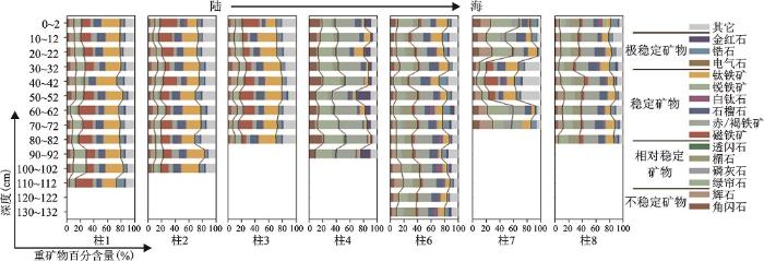
废黄河故道9个站位(柱1~柱9)中,有2个站位(柱5和柱9)由于沉积物颗粒较细,基本不含砂质成分,因此没有检测重矿物含量。其余站位的重矿物含量分布见图2。废黄河故道沉积物中重矿物种类较多,可达15余种。重矿物相对百分含量较低,在0.02%~0.89%之间变化,平均为0.19%。根据矿物的稳定性可将重矿物分为4类,研究结果显示:废黄河故道沉积物中以稳定矿物(平均47.22%)为主;相对稳定矿物(平均19.93%)和不稳定矿物(平均11.97%)含量次之;极稳定矿物(平均8.23%)含量最低。
对于不同站位,不稳定矿物含量在4.29%~29.83%之间变化。其中,柱 4 和柱 7含量较高,分别为15%和20%。而其它站位不稳定矿物平均含量只有10%。柱 4角闪石含量较高;柱 7辉石含量较高。不稳定矿物的时空变化趋势不明显。相对稳定矿物在8.25%~41.52%之间波动变化。其中,绿帘石和榍石构成主要的相对稳定矿物,且具有明显的空间变化趋势,即其含量由陆向海增加。但其随时间变化的趋势并不明显。稳定矿物含量在15.65%~61.60%之间变化,同样具有明显的空间变化规律。然而,稳定矿物内不同的矿物间,其空间变化规律相差很大。例如,磁铁矿和钛铁矿由陆向海表现为含量降低的趋势。赤/褐铁矿由陆向海其含量逐渐增加。稳定矿物同样没有显著的时间变化趋势。极稳定矿物含量在1.96%~21%之间变化。锆石构成极稳定矿物中最主要成分。极稳定矿物没有显示明显的时空变化规律。总体而言,废黄河故道沉积物中重矿物含量较低,无明显时间变化规律。
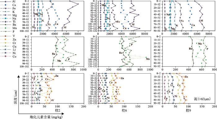
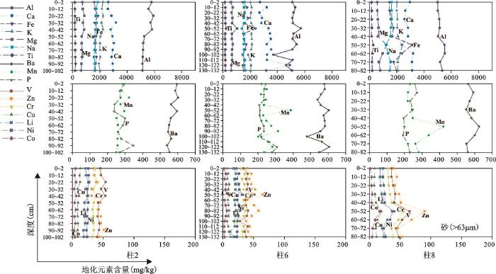
基于废黄河故道沉积物中Al元素含量随深度的变化趋势,以及其它大部分元素与Al元素之间呈显著的相关关系(表1),可将废黄河故道沉积物柱状样中不同粒径间地球化学元素含量的变化趋势可以归纳为3种:降低趋势(柱 2)、稳定趋势(柱 6)和增加趋势(泥质:柱 9;砂质:柱 8)(图3和图4)。对于泥质沉积物(图3),柱 2中Al的含量从表层80 120 mg/kg降低到底层52 670 mg/kg。与Al元素变化趋势相似,其它元素(Fe, K, Mg, Ba, Zn, Cu, Li, Ni, Co和Mn)含量也显示了随深度增加而降低的变化趋势。也有部分元素(Na,Ti,Ca,P,V,Cr)含量随深度增加而呈现升高的变化趋势。柱 6中Al元素含量随深度增加在6 000 mg/kg上下变化。其它元素(除了Na元素)均显示了与Al元素含量相似的稳定变化趋势,且均成正相关关系。Na含量同样随深度变化稳定,但与Al元素呈显著负相关关系。柱 9中Al元素含量从表层5 500 mg/kg增加到底层6 800 mg/kg。除了Na和P元素,其余元素含量均呈现与Al元素相似的变化趋势。Na元素含量随深度的增加而降低,而P元素随深度增加其含量一直在640 mg/kg上下波动。
图2 废黄河故道不同站位柱状样中重矿物含量分布
Fig.2 Spatial and temporal variations in the heavy mineral composition in the different sedimentcores within the abandoned Yellow River channel
表1 废黄河故道不同站位柱状沉积物中Al元素与其它化学元素含量的相关系数
Table 1 Correlation coefficients between the contents of Al and other chemical elements in the different cores from the abandoned Yellow River channel
| Ca | Fe | K | Mg | Na | Ti | Ba | Mn | P | V | Zn | Cr | Cu | Li | Ni | Co | |
|---|---|---|---|---|---|---|---|---|---|---|---|---|---|---|---|---|
| 泥质沉积物 | ||||||||||||||||
| 柱 2 | -0.32 | 0.71* | 0.82* | 0.81* | -0.68* | -0.65* | 0.88* | 0.36 | -0.48 | -0.17 | 0.85* | -0.32 | 0.83* | 0.82* | 0.83* | 0.85* |
| 柱 6 | 0.81* | 0.80* | 0.81* | 0.86* | -0.79* | 0.28 | 0.78* | 0.23 | 0.20 | 0.86* | 0.83* | 0.82* | 0.85* | 0.88* | 0.85* | 0.53 |
| 柱 9 | 0.94* | 0.98* | 0.96* | 0.91* | -0.98* | 0.75* | 0.94* | 0.77* | -0.10 | 0.99* | 0.92* | 0.98* | 0.96* | 0.98* | 0.96* | 0.87* |
| 砂质沉积物 | ||||||||||||||||
| 柱 2 | -0.34 | 0.29 | 0.95* | 0.89* | 0.78* | -0.76* | 0.89* | 0.90* | -0.45 | 0.87* | -0.85* | 0.80* | 0.77* | 0.87* | 0.63* | 0.44 |
| 柱 6 | -0.22 | 0.60* | 0.84* | 0.48 | 0.04 | 0.54* | 0.73* | 0.44 | -0.03 | 0.84* | 0.66* | 0.91* | 0.46 | 0.57* | 0.50 | 0.52 |
| 柱 8 | 0.09 | 0.90* | 0.86* | 0.92* | -0.89* | 0.89* | 0.54 | 0.89* | -0.64 | 0.92* | 0.85* | 0.90* | 0.83* | 0.88* | 0.91* | 0.82* |
图3 废黄河故道各站位泥质沉积物(<63 μm)中地球化学元素含量垂向变化趋势
Fig.3 Downcore variations in geochemical element contents in the mud fractions (<63 μm)
in the cores from the abandoned Yellow River channel
砂质沉积物显示了与泥质沉积物相似的变化规律(图4)。然而,砂质沉积物中地球化学元素的时空变化幅度均小于泥质沉积物,表明砂质沉积物中地球化学元素含量更趋于稳定。此外,除了Na和Ba元素,砂质沉积物其余元素的含量均显著低于泥质沉积物中相应元素的含量。Na在砂质沉积物中的浓度在9 918~18 966 mg/kg之间变化,远高于泥质沉积物中Na元素的含量(5 491~16 190 mg/kg)。
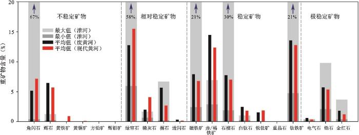
废黄河故道沉积物与现代黄河河道沉积物中重矿物平均含量对比结果见图5。结果显示,废黄河故道沉积物的不稳定矿物中,角闪石平均含量(5.16%)明显低于现代黄河河道沉积物中角闪石的平均含量(7.15%)。辉石平均含量(6.43%)略高于现代黄河河道沉积物中辉石的平均含量(5.70%)。其它矿物如:黄铁矿,黄铜矿,方铅矿和辉钼矿在现代黄河河道沉积物中能够被检测到,而这些矿物在废黄河故道沉积物中则没有被检测到。总体而言,废黄河故道沉积物中不稳定矿物总含量为11.61%,低于现代黄河河道沉积物中不稳定矿物的总含量(13.96%)。
图4 废黄河故道各站位砂质沉积物(>63 μm)中地球化学元素垂向变化趋势
Fig.4 Downcore variations in geochemical element contents in the sand fractions (>63 μm) in the cores from the abandoned Yellow River channel
相对稳定矿物中的主要矿物绿帘石在废黄河故道沉积物中的平均含量为12.77%,显著低于现代黄河河道沉积物中绿帘石的平均含量(15.48%)。磷灰石的平均含量也显著低于现代黄河河道沉积物中的平均含量。而其它相对稳定矿物,如榍石和透闪石在废黄河故道沉积物中的平均含量(5.64%和0.34%)则略低于现代黄河河道沉积物中的平均含量(2.69%和0.18%)。废黄河故道沉积物中相对稳定矿物的总含量(20.75%)低于现代黄河河道沉积物中相对稳定矿物的总含量(22.41%)。
对于稳定矿物而言,锐钛矿在废黄河故道沉积物中的平均含量为 1.55%,略低于现代黄河河道沉积物中锐钛矿的平均含量(1.85%)。重晶石在废黄河故道沉积物中没有被检测到,但在现代黄河河道沉积物中却被检测到。除锐钛矿和重晶石以外的其它稳定矿物,其平均含量均明显高于现代黄河河道沉积物中的平均含量。因此,废黄河故道稳定矿物总含量(47.76%)也显著高于现代黄河河道沉积物中稳定矿物的总含量(42.56%)。
对于极稳定矿物而言,废黄河故道沉积物中3种极稳定矿物的含量明显高于现代黄河河道沉积物。因此,在废黄河沉积物中极稳定矿物的总含量(8.18%)也显著高于现代黄河河道中的含量(6.93%)。
总体而言,废黄河故道沉积物中不稳定矿物和相对稳定矿物含量略低于现代黄河河道沉积物中的含量,然而稳定矿物和极稳定矿物含量则显著高于现代黄河河道沉积物中的含量;由此表明,废黄河沉积物中重矿物种类和含量明显区别于现代黄河河道沉积物。
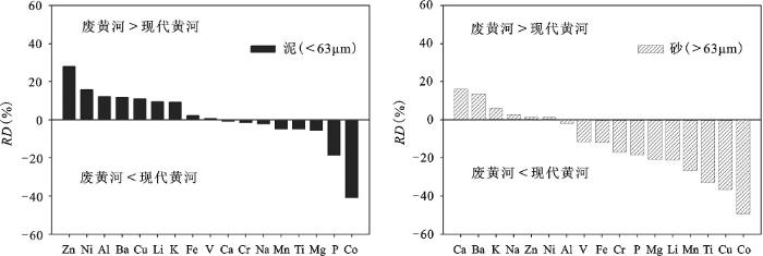
图6为废黄河故道与现代黄河河道沉积物不同粒级地球化学元素的相对含量偏差(RD)分布情况。泥质沉积物,Zn,Ni,Al,Ba,Cu,Li和K在废黄河故道沉积物中的浓度明显高于现代黄河河道沉积物中的相应含量。RD值均超过10%。Zn的RD值甚至超过20%。表明这些元素在废黄河泥质沉积物中较现代黄河泥质沉积物中富集。P和Co元素在废黄河故道沉积物中的浓度明显低于现代黄河河道沉积物中的相应浓度,其RD值也均超过20%。表明这2种元素在现代黄河河道泥质沉积物中较富集。砂质沉积物,只有Ca,Ba,K这3种元素明显富集于废黄河故道砂质沉积物中,而其余大部分元素(V,Fe,Cr,P,Mg,Li,Mn,Ti,Cu,Co)则更多富集在现代黄河河道的砂质沉积物中。由此表明:第一,废黄河故道沉积物中地球化学元素含量明显区别于现代黄河河道沉积物中对应元素的含量。第二,泥质沉积物,元素更多富集于废黄河故道沉积物中;砂质沉积物,元素更多富集于现代黄河河道沉积物中。
图5 废黄河、现代黄河和淮河沉积物中重矿物含量对比
Fig.5 Comparison of heavy mineral percentages for the sediments of the abandoned Yellow River, modern Yellow River and the Huaihe River
图6 废黄河河道与现代黄河河道沉积物不同粒径中地球化学元素的相对含量偏差(RD)
Fig.6 Comparison of relative deviation (RD) contents of geochemical elements between the abandoned Yellow River and modern Yellow River
基于沉积物中重矿物和不同粒级中地球化学元素分析,结果表明废黄河故道沉积物与现代黄河河道沉积物性质存在明显差异性。一般认为控制沉积物性质的因素主要包括:源岩(流域岩石组成)、构造及其气候影响的化学风化与物理风化、水动力作用、沉积盆地地形、沉积环境、沉积介质的物理化学性质、成岩及变质作用等[28]。由于废黄河和现代黄河沉积是同一条河流在不同区域的沉积记录。因此,以现代黄河作为背景参考值,那么造成废黄河沉积与现代黄河沉积的差异性可以归纳为2点:一是风化作用和流域物源随时间变化的影响,二是废黄河沉积过程中其它河流物质补给的影响。
化学蚀变指数(CIA)是评估化学风化强弱的有效指标[29~31]。化学风化越强,CIA值越高;化学风化越弱,CIA值则越低。经计算,废黄河泥质沉积物的CIA值在53~74之间变化,平均值为60;砂质沉积物的CIA值在38~57之间变化,平均值为45。与现代黄河沉积相对比,其泥质沉积相差不大(现代黄河CIA:52~67;平均值:57),而砂质沉积的CIA值却明显小于现代黄河沉积(现代黄河CIA:43~66;平均值:52)。表明化学风化作用是导致废黄河砂质沉积差异的因素之一。此外,现代黄河沉积中的K、Na、Ca、Al、P等元素是不稳定化学元素,可能现代过程还受到人类活动输入的影响,这也可能造成一定的差异。要注意的是,砂质沉积物中,稳定重矿物和极稳定重矿物的化学风化率很低,也不易受不稳定元素的影响,故仅凭上述第一个因素难以解释废黄河与现代黄河沉积的差异性。在废黄河沉积形成过程中,造成其沉积物性质与现代黄河沉积明显差异性的因素可能还有其它河流物质的补给。
分析探讨废黄河三角洲沉积记录中来自其它河流物质的补给影响,需要了解废黄河三角洲的形成过程。许多学者详细研究探讨了此过程[7, 8, 11]。研究表明,废黄河河口以及三角洲发育具有明显的阶段性,在其发育的前期和后期,由于来水来沙的变化,河口水动力因素的差异,河口泥沙堆积形式也不同。1194~1494年,黄河由颍、淝、涡、摊、泅等河分流入滩,流路分散,决口频繁,泥沙主要淤积在黄淮河下游冲积平原上,河口淤积甚少,河口延伸缓慢[11]。1494~1855年,河道基本归于一流而夺淮,经兰阳、归德、虞城、砀山 徐州、宿迁、桃源等地,至清河会濉入海,结束了几百年多槽分流的局面,因而泥沙大量下排、海口淤积加重,延伸加速[11]。由此说明,黄河南下夺淮过程中携带了多条河流物质,共同被输运、堆积于河口以及江苏海岸。这里以淮河为例,结合当前淮河沉积物的研究成果,来探讨废黄河沉积记录中其它河流物质的补给影响。
有研究报道淮河下游河道沉积物中重矿物的特征[32],认为不同区域,淮河河道沉积物中重矿物含量变化较大。因此,本研究采用重矿物含量的最大值和最小值来表征淮河下游河道沉积物中重矿物的含量变化,以此来探讨与废黄河故道沉积物中重矿物的关系(图5)。淮河河道沉积物中相对较高含量的不稳定矿物和相对稳定矿物,对废黄河故道沉积物中的重矿物没有太大影响。例如,角闪石和绿帘石在淮河河道沉积物中具有较高的含量,然而,这种高含量的矿物却没有体现在废黄河故道沉积物中,相反,这2种矿物在现代黄河河道沉积物中的含量更高于废黄河故道沉积物中的含量。导致这种现象的原因可能有2种:第一,淮河沉积物对废黄河沉积物确实没有影响;第二,淮河沉积物对废黄河沉积物有影响,但是由于矿物稳定性差,经过长期的风化作用,转化为其他矿物。淮河沉积物中具有较高含量的稳定矿物(磁铁矿、石榴石、锐钛矿)和极稳定矿物(锆石和金红石),在废黄河故道沉积物中这些矿物同样含量较高,且高于现代黄河河道沉积物。表明黄河南下夺淮过程中,淮河河道沉积物确实影响了废黄河故道沉积的性质。与淮河河道沉积物和现代黄河河道沉积物相比,赤/褐铁矿在废黄河河道沉积物中具有较高的含量。这很有可能是由于其它铁矿物转化形成的。因为磁铁矿处于氧化环境下时容易转化成赤铁矿。黄河北归之后,废黄河河道处于氧化环境下,为磁铁矿转化为赤铁矿创造了有利条件。
同时淮河下游河道沉积物中地球化学元素的研究成果[33, 34]显示,Ba、Al和Zn等元素在淮河沉积物中具有较高的浓度,而这些元素在废黄河沉积物中同样具有较高的浓度,均高于现代黄河沉积物中的相应元素含量。例如: Ba元素在淮河沉积物中被检测到的浓度分别为533 mg/kg和632 mg/kg,废黄河沉积物中Ba元素平均浓度分别为480 mg/kg(泥质沉积物)、571 mg/kg (砂质沉积物),而现代黄河沉积物中Ba元素浓度只有430 mg/kg (泥质沉积物)、500 mg/kg (砂质沉积物)。即,淮河沉积物中的Ba元素明显高于现代黄河沉积物中的浓度。与Ba元素类似,Al和Zn元素在淮河沉积物中同样具有较高的浓度,这些元素在废黄河沉积物中的浓度同样高于现代黄河沉积物。由此推断,淮河沉积物对废黄河沉积物的贡献确实改变了废黄河沉积物的性质,使其不同于现代黄河沉积物。
鉴于以上的分析和探讨,我们认为废黄河沉积记录可以反映来自于其它不同河流物质的信息。但是目前的研究还不是很充分,还需深入探讨历史时期黄河南下夺淮过程中,途径的小河流以及淮河物质在多大程度上影响废黄河沉积物。要解决这个问题,需要综合考察包括淮河流域在内的多个流域的沉积物性质以及废黄河三角洲大范围内的沉积物性质。同时,由于废黄河和现代黄河沉积物性质的差异性,在定量追踪黄河在邻近海岸与陆架堆积区的物源研究中,应建立废黄河和现代黄河各自不同的源区示踪标记,使物源分析结果更加准确。
1) 废黄河沉积物中重矿物平均含量为0.19%,种类较多,达15余种,其相对含量中以稳定矿物为主,且不同种类矿物时空变化差异较大。废黄河河道泥质和砂质沉积物中,地球化学元素随深度变化可分为降低、稳定和增加的不同变化格局。
2) 废黄河故道沉积物与现代黄河河道沉积物性质存在明显差异性:废黄河沉积物中稳定和极稳定矿物相对含量较高,而现代黄河沉积物中不稳定矿物和相对稳定矿物总含量较高。废黄河泥质沉积物中更多富集Zn,Ni,Al,Ba,Cu,Li,K等元素,而砂质沉积物中,V,Fe,Cr,P,Mg,Li,Mn,Ti,Cu,Co等元素更多富集于现代黄河沉积物中。
3) 废黄河和现代黄河沉积物间的差异性反映出包括淮河在内的其它不同河流物质对废黄河物质补给的影响。淮河沉积物中重矿物和地球化学元素的研究提供了一些证据,然而关于这些河流各自的定量贡献目前尚不能分析,有待进一步探讨。同时,在定量研究邻近海岸与陆架沉积物物源追踪中,应建立废黄河和现代黄河各自不同的源区示踪标记,使物源分析结果更加准确。
The authors have declared that no competing interests exist.
| [1] |
ed.). Continental margin sedimentation: from sediment transport to sequence stratigraphy (IAS Special Publication 37) [M]. |
| [2] |
The geology of stratigraphic sequences (2nd ed) [M].
|
| [3] |
中国东部陆架全新世沉积体系:过程-产物关系研究进展评述 [J].
渤、黄、东海是典型的物源供给丰富的宽广陆架环境,形成的全新世沉积 记录十分丰富。本区域潮汐作用、陆架环流作用和沉积物重力流导致的物质输运都很活活跃;陆架沉积动力过程与全新世沉积体系的空间分布、物质组成、堆积速 率、层序年代等特征相联系。全新世陆架与海岸沉积具有高分辨率、空间分布的不连续和沉积记录的片段性等特征。江苏海岸全新世中期海岸沉积、杭州湾全新世早 -中期沉积、浙闽沿岸全新世沉积和其他陆架泥质沉积可从物质来源(海面上升中的沉积改造相河流入海j通量)、输运一堆积过程、沉积层序形成的先后次序、陆 架沉积记录的未来状况等方面进行分析。数值模拟可用以深化本区的过程-产物关系研究。
|
| [4] |
|
| [5] |
Quantitative models of sediment generation and provenance: state of the art and future developments [J]. |
| [6] |
A unique Yellow River-derived distal sub-aqueous delta in the Yellow Sea. https://doi.org/10.1016/j.margeo.2007.02.008 URL [本文引用: 1] 摘要
Newly acquired high-resolution Chirp sonar profiles reveal a unique Yellow River-derived, alongshore distributed, bidirectional (landward and seaward) across-shelf transported, omega-shaped (“Ω”) distal subaqueous deltaic lobe deposited around the eastern tip of the Shandong Peninsula in the Yellow Sea. This clinoform deposit directly overlies the postglacial transgressive surface, featured by convex-up seafloor morphology, up to 40m thick locally. Radiocarbon-14 dates from the underlain pre-Holocene and transgressive sediments indicate this distal lobe has formed since the middle-Holocene highstand under a relatively stable sea level. This along-shelf distributed distal clinoform has been deposited mainly by the resuspended Yellow River sediments carried down by the coastal current, interacting with the local waves, tides and upwelling. Collectively, over the past 7000years, nearly 30% of the Yellow River-derived sediment has been re-suspended and transported out of the Bohai Sea into the Yellow Sea. Overall, the Yellow River-derived sediment could reach the 610280m water depth in the central South Yellow Sea, about 700km from the river mouth; in contrast, a very small fraction of the modern riverine sediment could escape the outer shelf or reach the Okinawa Trough.
|
| [7] |
废黄河三角洲的演变 [J].https://doi.org/10.11821/yj1991040004 URL Magsci [本文引用: 2] |
| [8] |
苏北黄河三角洲及滨海平原的成陆过程 [J].https://doi.org/10.11821/xb198402005 URL [本文引用: 1] 摘要
历史时期的黄河以善决善徙闻名于世。其尾闾入海路线大致可归结为三条。或北道由天津附近入渤海,历时二千四百余年;或中路趋山东利津入海,历时一千四百余年;或南线出云梯关入黄海,历七百余年。虽然黄河在历史时期中影响江苏海岸的时间并不算长,
|
| [9] |
Modeling the preservation potential of tidal flat sedimentary records, Jiangsu coast, eastern China [J].https://doi.org/10.1016/j.csr.2008.12.010 URL 摘要
A forward modeling approach is proposed to simulate the preservation potential of tidal flat deposits. The preservation potential is expressed as a function of net deposition rate and a factor that represents the vertical flux of suspended load, or seabed lowering during erosion periods associated with bedload transport. The model takes into account a number of geometric parameters of a tidal flat sediment system and sediment dynamic processes. The former includes high water level, total sediment supply, the annual rate of the supply, the ratio of mud to bilk sediment in the supply, the bed slope of the tidal flat profile, as well as the slope of the stratigraphic boundary; the latter includes spring-neap cycles of tidal water level changes, boundary layer processes, resuspension of fine-grained sediments, bedload transport due to tidal currents, and bed elevation changes in response to sediment movement. Using this model, numerical experiments are carried out for a tidal flat system on the Jiangsu coast, eastern China, with the input data being derived from literature and from a series of sediment cores collected along an onshore-offshore transect. The results show that the preservation potential is highest over the upper part of the inter-tidal zone and in the lower part of the sub-tidal zone, and lowest near mean sea level and at low water on springs. The preservation potential tends to decrease with the advancement of the shoreline. The bed slope, tidal current direction and resuspension intensity influence the spatial distributions of the preservation potential. An implication of these results is that the temporal resolution of the tidal flat record depends upon the location and depth within the deposit; this should be taken into account in the interpretation of sedimentary records. Further studies are required to improve the model, on the hydrodynamic processes associated with extremely shallow water depths, sediment dynamic modeling of bed slope and profile shape, and the combined action of tides and waves for sediment transport on tidal flats.
|
| [10] |
Subaqueous deltaic formation of the old yellow river (AD 1128~1855) on the western south yellow sea [J].https://doi.org/10.1016/j.margeo.2013.07.003 URL Magsci [本文引用: 1] 摘要
The Yellow River presently flows into the Bohai Sea, but during the period AD 1128-1855, the river (called the Old Yellow River, OYR) flowed into the western South Yellow Sea (SYS), where the dispersal of its sediment load was controlled by the interactions among alongshore currents, waves and tides, and shelf morphology. In this study, high-resolution shallow seismic profiles, vibrocores, boreholes, and water depth data, which were obtained during geological surveys in the western SYS in recent years, are used to examine the depositional pattern and stratigraphic record related to the OYR entering the sea. Our data reveal compound clinoform morphologies (double clinoforms) - a subaerial/subaqueous delta couplet - sourced by the OYR in the western SYS. The subaerial delta comprises the currently onshore delta plain and deltafront extending to similar to 17 m in water depth, while the subaqueous delta is composed of a wide, gently inclined topset and a relatively narrow, steeply sloping foreset, stretching seaward about 160-km away from the shoreline and showing a morphological asymmetry with a generally southward deflection relative to the OYR mouth. The topset is 25-100-km wide in a shore-normal direction at water depths of 10-25 m, but is generally less than 4-m thick. The foreset is much narrower and thicker than the topset, is generally 5-30-km wide at 10-45 m water depth and is mostly 4-16-m thick with a maximum thickness of 20 m; it shows seaward-dipping internal reflectors (generally 0.3-0.5 degrees). The rollover points (topset-foreset transition) of the subaqueous clinoform range mostly between 10 and 25 m water depth. Results of Pb-210 and Cs-132 geochronology indicate that maximum sediment accumulation rates (1.06 to 2.16 cm/yr) correspond to the foreset region, with much lower rates in the topset and surrounding shallow-sea regions (<0.64 cm/yr). Marine erosion due to abandonment of the delta after 1855 and artificial dike building around the abandoned delta coast since the 1930s have impacted the sediment accumulation in the delta front in the subaerial delta and subaqueous delta. Estimates of sediment budget suggest that about 34-52% of the total load primarily from the OYR (>97%) in AD 1128-1855 has accumulated on the subaerial delta, and that about 10-16% of the total load on the subaqueous delta. Our data also reveal that the subaqueous delta related to the OYR is underlain by a large-scale clinoform (broadly confined to similar to 2.5-9.8 cal kyr BP in age) as thick as 4-13 m with seaward-dipping lower angled (<0.3 degrees) internal reflectors in comparison to those in the overlying foreset deposits. Energetic marine hydrodynamics (waves, tides, and alongshore coastal-currents) and sufficient sediment supply from the OYR are interpreted to be responsible for the across-shelf subaqueous delta morphology. (C) 2013 Elsevier B.V. All rights reserved.
|
| [11] |
试论苏北废黄河三角洲的发育 [J].https://doi.org/10.11821/xb198602002 URL [本文引用: 4] 摘要
正废黄河三角洲是黄海的古三角洲,它形成于明、清黄河南流的时期(1194—1855年)。笔者根据近年来实地考察和前人的研究资料,重点讨论了三角洲的形成范围、地貌结构及其沉积特点,发育模式和形成机制以及它对上游河道发育的影响,这有助于现代黄河三角
|
| [12] |
苏北沿海暗沙成因的研究 [J]. |
| [13] |
黄河输沙及其对渤海、黄海沉积作用的影响 [J].
黄河的年输沙量约为11×10~8吨,占世界21条大河入海泥沙总量的17%。黄河约有90%的泥沙来自中游的黄土高原,其年输沙最的70%发生在7~9月。黄河的泥沙输送对渤海和黄海海岸带地貌及沉积作用有广泛和深远的影响。
|
| [14] |
The characteristics of the China coastline [J].https://doi.org/10.1016/0278-4343(87)90104-X URL 摘要
The coastal classification of Wang (1980, Geoscience Canada , 7, 109–113) is applied to the coast of China, dividing China into four major sectors. Relative impact of rivers, waves and tides on coastal processes in each of these sectors varies widely, ranging from river-dominated in the Bohai Sea sector, to wave-dominated in the southern Guangdong/Guanxi sector. This classification and discussion summarizes major studies of coastal processes in China.
|
| [15] |
废黄河口海岸侵蚀与对策 [J]. |
| [16] |
长江三角洲及苏北沿海地区7000年以来海岸线演变规律分析 [J].https://doi.org/10.1007/BF02029074 URL Magsci 摘要
贝壳堤是重要的海岸标志物,长江三角洲上海地区有9条贝壳砂堤,苏北北,中部沿海区各有4条贝坝砂堤或沙坝,根据贝壳砂堤分布特点和测年数据结合新石器时代以来文化遣址分布规律,探讨总结华东涡海古海岸线演变规律。
|
| [17] |
南宋以来江苏海岸带历史海岸线时空演变研究 [J].
历史海岸线变迁研究是海岸带研究的一个重要方面,对于海岸带的利用、开发与保护有重要的意义。以江苏海岸带为研究对象,结合数字海岸线分析系统分区段建立有效的海岸线分析断面,并计算各个区段的海岸线历史变化,对南宋至今约1000a来的历史海岸线变迁进行定量和定性分析,揭示海岸线时空变迁背后的驱动力。结果表明废黄河口地区变化剧烈,最大淤涨速率和侵蚀速率分别达250、600m/a,塑造其剧烈变化的动因是公元1128年的黄河夺淮与公元1855年的黄河北归;此外,近代废灶兴垦等人类活动也导致了辐射沙洲北部及南部变化明显。
|
| [18] |
江苏废黄河口外夏季悬浮泥沙运动 [J].
利用对江苏北部废黄河口水下斜 坡和平坦海床上同步声学多普勒测流仪(ADP)测流和悬浮体取样数据,分析了本区近海水动力条件和泥沙运移。三站的同步调查显示,本海区潮周期悬沙净通量 方向以南向为主,净通量在103~104kg/m之间。依据三站同步资料,初步估算穿过本区的泥沙通量接近长期侵蚀输沙的平均值。潮周期内悬浮泥沙含量呈 周期性变化,靠近岸边浅水区的悬浮泥沙含量变化尤其明显。流速数据和悬浮体含量数据对比显示,底层流速与悬浮体含量的关系密切。这说明悬浮体含量变化与海 底沉积物的再悬浮有关。悬沙含量峰值出现在急流后,ADP测流垂向断面数据显示急流时,流速梯度高,因而,急流时有较大的剪切速度,使沉积物受到侵蚀或再 悬浮,从而使悬沙含量在急流后达到峰值。
|
| [19] |
Coastal erosion as a major sediment supplier to continental shelves: Example from the abandoned Old Huanghe (Yellow River) delta [J].https://doi.org/10.1016/j.csr.2014.03.015 URL [本文引用: 1] 摘要
The Old Huanghe (Yellow River) delta in Jiangsu Province, China, has suffered intense erosion since the river mouth changed from the Yellow Sea to the Bohai Sea in 1855, and this erosion has since been the dominant sediment source to the Yellow Sea and East China Sea. To analyze the topographic and bathymetric changes to the Old Huanghe delta area and derive a regional sediment budget, we extracted shoreline positions and bathymetry from charts and maps published since 1875 and georectified these data into a common coordinate system, combining them with extensive single-beam bathymetric survey data acquired between 2002 and 2008 off Jiangsu Province. The results show continuous seabed erosion throughout the 20th century, consisting of the retreat of shoreface morphology in the nearshore zone (mostly <15-m depth) and deepening of the flat seabed offshore (15 to ~20 m). Off the abandoned river mouth of the Old Huanghe, historically persistent sandbanks disappeared and other recent sandbanks shrank. Sediment yielded by coastal erosion from depths of <20 m has amounted to >790 Mt annually on average for the last 100 years. Of this very large amount of sediment, ~25% is deposited on the offshore slope in the western Yellow Sea, another 20鈥25% is deposited along the south Jiangsu coast as far as the Changjiang (Yangtze) river delta, and the rest is transported southeastward along the mud belt that crosses the central Yellow Sea to south of Cheju Island in the East China Sea. This amount is an order of magnitude larger than the sediment supply from the modern Huanghe River to the Yellow Sea and also greatly exceeds the present sediment discharge of the Changjiang River.
|
| [20] |
苏北废黄河水下三角洲沉积范围研究述评 [J].https://doi.org/10.11821/dlxb201501003 URL Magsci [本文引用: 1] 摘要
详细梳理现有研究成果,目前对1128-1855年废黄河水下三角洲沉积范围的划分可总结为三类主要观点①外缘位于废黄河口外近岸、远岸斜坡带之间的宽缓平台(水深范围-15~-25m)之上;②外缘位于废黄河口外远岸斜坡带(水深范围-25~-45m)之外;③外缘可达-45m等深线之外,且废黄河三角洲由一个近岸/远岸复合楔形沉积体构成。综合分析废黄河水下三角洲海域海底地形地貌、浅部地层沉积特征与14C年代、浅层声学地层等资料数据表明,1128-1855年废黄河水下三角洲的延伸范围应该超过现今-20m等深线,但未越过远岸斜坡带;远岸斜坡带发育的厚层楔形体不大可能是废黄河三角洲前缘沉积层,其确切成因、物源与年代等问题尚有待于进一步深入研究。为准确圈定1128-1855年废黄河水下三角洲沉积范围,需要对完整覆盖本区的高质量浅层地震剖面进行解译分析,在其三大地形单元(近岸、远岸斜坡带及其之间宽缓平台)内补充钻孔分析,并参考1875年以来各期海图资料来进行综合判定。
|
| [21] |
试论南黄海中部泥的物源及成因 [J]. |
| [22] |
南黄海表层沉积物物质来源的逐步判别分析 [J].https://doi.org/10.3321/j.issn:0371-5736.2000.z1.051 URL 摘要
1998年6月,获取南黄海表层沉积物样品61个,黄河、长江 中、上游细粒泛滥平原沉积物样品24个.在对后者17个地球化学指标测试的基础上,利用逐步判别分析方法,筛选出7个指标(Ti、Cu、K2O、Zn、 Na2O、A12O3和CaO),做为识别黄河、长江物质组成的有效参数,并构造黄河、长江两个物源端元的判别函数Y1和Y2.利用判别函数,分别计算出 南黄海61个表层沉积物的函数值,进而对其物源属性进行识别.判别结果表明,南黄海表层沉积物按物源属性分为三大区:A-长江物质优势区;B-黄河物质优 势区;C-长江、黄河物质混合区.
|
| [23] |
南黄海沉积物的来源及分区:来自轻矿物的证据 [J].
利用南黄海222个沉积物样品的轻矿物鉴定资料,对南黄海的轻矿物百分含量分布进行了详细的划分,突出了极高值和低值含量的分布.划分出5个轻矿物组合分区Ⅰ-南黄海北部矿物区,物质主要来源于黄河;Ⅱ-南黄海中部矿物区,物质多来源于黄河,一部分来源于长江;Ⅲ-混合矿物区,物质来源受黄河、长江的双重影响;Ⅳ-长江口东部矿物区,物质主要来源于长江;Ⅴ-南黄海南部矿物区,物质来源可能受残留沉积影响,且受现代长江的影响较大.区分出5个轻矿物分区的优势矿物组合以及特征矿物.
|
| [24] |
南黄海粘土矿物分布特征及其指示意义 [J].
用X射线衍射仪技术分析了南黄海88个表层沉积物样品的黏土矿物含量及组合特征,编制了最新、最全面的黏土矿物分布图,阐述了海区内4种黏土矿物(伊利石、绿泥石、高岭石和蒙皂石)的分布特征.研究表明,南黄海黏土矿物主要为陆源成因,黄河是其主要物质供给者.最后讨论了南黄海的泥质沉积来源南黄海中部的泥质沉积,其北半部分以黄河物质为主,其中部和南部则是“多源”混合沉积而成的;南黄海东南部的泥质沉积,其北半部含较多的锦江和英山江的物质,其南半部则系多源沉积的产物.
|
| [25] |
~1997~中外标准~HBBASE~1997~1 . |
| [26] |
ICP~AES技术应用的研究进展 [J].
ICP-AES分析技术以其快 速、准确、灵敏等特点,广泛应用于环境、地矿、冶金、生物、食品、石油、医学检验等领域中的多元素分析,其分析技术和仪器已日益完善。本文根据ICP- AES分析技术热点领域的应用,重点总结了近年来ICP-AES在环境水体样品、地矿样品、冶金样品、生物样品及食品样品分析中的应用研究进展,并对其发 展历程、方法原理、优缺点及发展前景作了简要的论述与展望。
|
| [27] |
长江与黄河现代表层沉积物元素组成及其示踪作用 [J].https://doi.org/10.1088/0256-307X/16/9/027 URL [本文引用: 1] 摘要
长江与黄河现代表层沉积物中常量及微量元素组成特征明显不同。长江相对富K、Fe,Al等常 量元素及绝大多数微量元素,且元素含量变化大;而黄河相对富Ca,Na,Sr,Zr,Hf等少数元素,元素含量变化较 小;Cu,Zn,Sc,Ti,Fe,V,Ni,Cr,Mn,Li,Zr,Hf,Al等元素及La/Sc,Th/Co,La/Co,Ti/Zr,Zr/Y等 元素比值可较好地用来区分长江与黄河沉积物,以探索长江与黄河的
|
| [28] |
Heavy mineral assemblages of continental margins as indicators of plate-tectonic environments [J].https://doi.org/10.1111/j.1525-1314.1993.tb00198.x URL [本文引用: 1] 摘要
Heavy-mineral assemblages of continental margins as indicators of plate-tectonic environments NECHAEV V. P. Journal of Sedimentary Petrology 63, 1110-1117, 1993
|
| [29] |
Early proterozoic climates and plate motions inferred from major element chemistry of lutites [J].https://doi.org/10.1038/299715a0 URL [本文引用: 1] 摘要
The early Proterozoic Huronian Supergroup of the north shore of Lake Huron (Fig. 1) is a thick (up to 12,000 m) succession of sedimentary and volcanic rocks deposited between about 2,500 and 2,100 Myr ago. Here we present a palaeoclimatic interpretation of the Huronian based on approximately 200 major elements analyses of lutites. Most of these are new analyses from the Gowganda and Serpent Formations (Fig. 2). The remainder are from published sources cited in Fig. 4. The composition of lutites from the Huronian Supergroup records an early period of intense, probably tropical, weathering followed by climatic deterioration that culminated in widespread deposition of glaciogenic sediments of the Gowganda Formation. Climatic amelioration followed during deposition of the succeeding Huronian formations. The Huronian succession can be interpreted using a uniformitarian approach in that present day seafloor spreading rates and latitude-related climatic variations are compatible with available geochronological and palaeomagnetic data.
|
| [30] |
A review of the Chemical Index of Alternation (CIA) and its application to the study of Neoproterozoic glacial deposits and climate transitions [J].https://doi.org/10.1146/annurev-earth-040809-152447 URL 摘要
ABSTRACT The Neoproterozoic is a time of transition between the ancient microbial world and the Phanerozoic, marked by a resumption of extreme carbon isotope fluctuations and glaciation after a billion-year absence. The carbon cycle disruptions are probably accompanied by changes in the stock of oxidants and connect to glaciations via changes in the atmospheric greenhouse gas content. Two of the glaciations reach low latitudes and may have been Snowball events with near-global ice cover. This review deals primarily with the Cryogenian portion of the Neoproterozoic, during which these glaciations occurred. The initiation and deglaciation of Snowball states are discussed in light of a suite of general circulation model simulations designed to facilitate intercomparison between different models. Snow cover and the nature of the frozen surface emerge as key factors governing initiation and deglaciation. The most comprehensive model discussed confirms the possibility of initiating a Snowball event with a plausible reduction of CO2. Deglaciation requires a combination of elevated CO2 and tropical dust accumulation, aided by some cloud warming. The cause of Neoproterozoic biogeochemical turbulence, and its precise connection with Snowball glaciations, remains obscure.
|
| [31] |
Multiple climate cooling prior to Sturtian glaciations: evidence from chemical index of alteration of sediments in South China [J].https://doi.org/10.1038/srep06868 URL [本文引用: 1] 摘要
Investigation of climatic conditions prior to the Sturtian glaciations is critical to understanding the trigger mechanism for the series of Neoproterozoic global glaciations. In this study, we report high-resolution chemical index of alteration (CIA) records in the sediments of South China prior to the Sturtian glaciation (820~720 Ma). Our results showed there occurred multiple climate cooling before the Sturtian glaciations in South China: (1) a series of episodic and possibly global climate cooling periods from ca. 750 Ma to 725 Ma, which also caused some diachronous regional glaciations; (2) a permanent climate cooling period between ca. 800 Ma and 770 Ma, probably contemporaneous to the global ``Bitter Springs stage'' 未C negative excursion; (3) a climate cooling period between ca. 815 Ma and 810 Ma. The three stages of climate cooling are also supported by their correspondence to previously reported extremely low 未O records of igneous/metamorphic minerals from South China. These climate cooling periods also coincide with the magmatism and rifting events in South China. We argue that tectonic movements were the primary control on the climate cooling before the Neoproterozoic global glaciations.
|
| [32] |
苏北兴化2孔晚中新世以来重矿物物源示踪研究[D] . |
| [33] |
淮河沉积物中21种无机元素环境标准样品的研制 [J].
正环境标准样品作为环境监测分 析的测量标准、量值传递的载体,是有效开展环境监测量值溯源的重要工具~([1])。水系沉积物中无机元素的检测是环境监测的主要项目之一~ ([2-3]),淮河流域水环境污染从20世纪80年代发生至今,形势非常严峻~([4])。淮河治污一直是各级环境监测部门较为关注的问题,但由于缺少 适用的环境基体标准样品,使得沉积物等
|
| [34] |
淮河中下游河道沉积物重金属元素分布特征研究[D] . |

/
| 〈 |
|
〉 |
