赵红艳 , 杨倩楠
, 杨倩楠
ZHAO Hong-yan, YANG Qian-nan
中图分类号: P531
文献标识码: A
文章编号: 1000-0690(2015)08-1014-07
收稿日期: 2014-01-20
修回日期: 2014-06-5
网络出版日期: 2015-08-20
版权声明: 2015 《地理科学》编辑部 本文是开放获取期刊文献,在以下情况下可以自由使用:学术研究、学术交流、科研教学等,但不允许用于商业目的.
基金资助:
作者简介:
作者简介:赵红艳(1969-),女,吉林榆树人,博士,副教授,主要从事自然地理与湿地生态研究。E-mail:hyzhao@nenu.edu.cn
展开
摘要
选择长白山地区2种不同类型的泥炭沼泽,进行了典型剖面的大气铅沉降研究。植物残体和泥炭性质表明老白山泥炭地已经发育到贫营养阶段,而大桥泥炭地还处于富营养状态。两地泥炭记录的总铅含量和沉降速率与中国其他地区在同一个数量级上。老白山泥炭记录的大气铅在总铅中占主导地位,大气铅与富集因子呈明显的正相关(r=0.874,n=16,p<0.01),且在16世纪中叶、18世纪初和20世纪出现峰值。大桥泥炭记录的铅可能存在再迁移和再沉降现象,但是相对较弱,因此,它也可以被用来重建当时的大气沉降。
关键词:
Abstract
Two peat profiles respectively form Laobaishan mire (44°06′N, 128°03′E) and Daqiao mire (43°17′N, 128°22′E) from Changbai Mountains in northeast China, were investigated to reconstruct atmospheric deposition since 2120 B.P., and decide whether Pb inventories in minerotrophic mires are mobile. The plant macrofossil types and characteristics of peat samples indicate Laobaishan mire has developed into ombrotrophic bog, and Daqiao mire is still in minerotrophic status. The largest concentration, accumulation rates of Pb in Laobaishan and Daqiao are 22.23-38.46 ug/g and 8.8-16.33 mg/(m2·y) respectively, and are in the same order of magnitude as the other places in the world. A positive correlation between lithogenic Pb and ash content (r=0.799,n=16,p<0.01) in Laobaishan profile indicate lithogenic Pb mainly from rock weathering underlying peat deposits. Atmospheric Pb is dominant in total Pb deposition that suggests cumulative Pb is most from atmospheric deposition. High enrichment factors of Pb in Laobaishan profile occurred in the middle of 16th century, the early of 18th century and 20th century. They are in good agreement with little ice age during the middle of sixteen centuries, volcano eruption happened in Changbai Mountains in 1702 and human activities in the 20th century. Pb content and accumulation rate recorded in Daqiao mires are the most value in the downmost layer. This corresponds with atmospheric soil dust flux very well. Moreover, the Pb enrichment factor is the greatest at the subsurface.
Keywords:
重金属铅及其化合物对人体各组织均有毒性。为了理解当前人类活动造成的铅污染程度,评价其长期环境行为,掌握历史记录的有关铅的信息很有必要。重金属铅的记录体包括极地冰雪、土壤、海洋或湖泊沉积物、各种生物介质(珊瑚、树轮和干标本)以及泥炭沼泽,这些载体提供了非常有价值的全球环境污染的年表[1]。关于以泥炭沼泽为载体的重金属铅的浓度、沉降速率及其与大气沉降的关系,最有代表性的是20世纪90年代Shotyk及其团队在瑞士Jura山脉开展的一系列工作[2~4],取得的研究结论包括,贫营养泥炭地仅受大气降水补给、酸性强,剖面内的铅被有效地固定,据此,可根据泥炭记录的大气铅的剖面变化,重现大气沉降的完整历史[5]。富营养泥炭地中铅沉降存在着再移动和再沉积的现象,使得铅浓度剖面不能完整地反映当时大气沉降[6,7]。但Shotyk认为,只要水-沉积物相互作用对泥炭中铅富集影响很小,富营养泥炭地有潜力提供准确的大气沉降的历史记录[8]。此后,类似的工作在欧洲大陆内部,包括西班牙、德国、法国、瑞典、比利时和北美等地区迅速开展[9~11],通过铅的富集因子、206Pb/207Pb比值和同一剖面时隔20 a的210Pb年代序列没有发生变化等研究结果,揭示贫营养泥炭记录的铅在剖面上基本不再移动,并以此重建当时的大气沉降。中国学者在铅的累积、迁移和转化等现代行为过程方面研究较多[12,13],对各种载体记录的历史时期铅沉降研究还远远不够[14],有关泥炭记录的剖面铅沉降的研究仅限于大小兴安岭和青藏高原地区,且主要针对贫营养泥炭的记录[15~17],对长白山地区,尤其是富营养泥炭记录的铅沉降研究很少。本文的研究目的有以下两个方面:其一,作为东北泥炭地集中分布区之一的敦化泥炭记录的剖面铅分布是否能够准确反映大气沉降。其二,富集的铅是人为造成的还是自然原因。
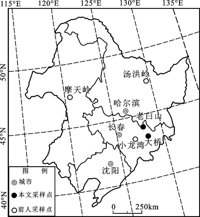
研究区位于吉林省境内张广才岭-威虎岭以东、哈尔巴岭-长白山以西的敦化盆地及其周围,属于狭义的长白山地。地理位置在40°40′N~44°30′N,125°20′E~131°20′E,距离长白山天池约200 km(图1)。该区受东亚季风控制,夏季温暖湿润,冬季漫长寒冷,年均温-2℃,与同纬度其他地区相比,夏季和冬季的气温都偏低,年降水量620~690 mm。该地是长白山区泥炭分布最集中的地区之一。老白山泥炭地(44°06′N,128°03′E,海拔1 610~1 696 m)发育在敦化盆地西北方向张广才岭顶部第三纪夷平面上,因山顶气候冷湿,地表排水不畅,形成大约10 hm2的泥炭沼泽。该泥炭地灌木层以偃松(Pinus pumila)为优势种,伴生有牛皮杜鹃(Rhododendron aureum)和越桔(Vaccinium vitisidaea)。草本层以狭叶棉花莎草(Eriophorum angustifolium)为单优势种,伴生有沼苔草(Carex limosa)、小白花地榆(Sanguisorba parviflora)和圆叶茅膏菜(Drosera rotundifolia)等沼泽植物。苔藓地被层以泥炭藓属植物为优势,并形成藓丘[18]。大桥泥炭地(43°17′N~43°20′N, 128°22′E~128°24′E,海拔350~400 m)发育在敦化盆地南部的山前集水地带,泥炭地总面积257.25 hm2,主体部分已经被开垦为农用地,地表植被为杂类草[19]。
2个泥炭地均采用人工剖面法取样。老白山剖面(10 cm×10 cm×54 cm,2003年8月取样)表层16 cm是活藓层,样品自活藓层向下一直到基底被完整无缺地移出,用塑料袋装好,转移到塑料器皿中,送到实验室。大桥剖面(20 cm×10 cm×140 cm,2000年6月取回)位于耕地边缘,是在自然冲沟旁边、去掉表层之后、在过渡层之上采集的样品,剖面特征见文献[20]。2个泥炭剖面都是用不锈钢刀分割成2.5 cm的切片。
本次用于测量Pb元素的样品含间隔2.5 cm的16个老白山样品和间隔5 cm的28个大桥样品。样品被自然风干,粉碎成80目。之后,用HNO3-HF-HClO3在200℃电热盘上进行完全消解氧化,然后转移到25 mL的试管中定容。元素Pb是在ZEEMAN AAS仪器上进行分析,同步测试使用土壤标准参考样GSS-3(国家标准物质GBW-07403),已知标样的Pb浓度为26±3 ug/g,实际测得的浓度是25.7±1.7 ug/g,满足质量控制要求。Zr是用PLASMA SPEC(Ⅰ)ICP-AES测定,标准差为1.10 ug/mL。样品的测量由东北师范大学分析测试中心完成。泥炭腐殖化度采用碱提取液吸光度法测定[21]。大桥剖面泥炭的pH、Al、Ti、Sr、Ca、Mg和有机质剖面变化见文献[20]。
本文使用Zr元素来计算Pb的富集因子,这是因为Zr元素是一种保守金属,没有明显的人为来源。Pb元素的富集因子计算公式为:
EF=([Pb]/[Zr])泥炭/([Pb]/[Zr])地壳 (1)
地壳中Pb、Zr的浓度分别为14.8 ug/g和203 ug/g[22]。
计算铅沉降速率时,本文参考Ferrat使用的方法[17],具体做法是:
铅沉降速率[mg/(m2·y)]=铅的浓度(ug/g)×样品厚度速率(cm/y)×容重(g/cm3)×10。
样品采用常规14C法定年。烘干的粉末状的样品经过处理,在密闭的真空系统中燃烧生成二氧化碳,被提纯后,通过氨水吸收,然后与SrCl2溶液反应,产生的SrCO3经过滤、冲洗、烘干,用镁法合成SrC2,水解成乙炔。乙炔经过一系列步骤纯化后,在CrO3-Al2O3-SiO2催化剂的作用下合成苯。在LKS公司Quantulus-1220型和国产FJ-2101型液闪仪上测量1 000 min左右。样品的年代校正采用华盛顿大学提供的年代校正软件(版本为4.1.2和4.3)。样品的测量在东北师范大学完成。
老白山泥炭剖面基底沉积物14C年龄为380±70 a B.P.,校正后的年龄为464 a B.P.。大桥泥炭地基底140 cm沉积物的14C年龄为2195±70 a B.P.,校正后的年龄为2 120 a B.P.,60 cm的泥炭年龄是1 410±70 a B.P.,校正后的年龄为1 290 a B.P.,年龄深度模型的建立采用线性内插法。这种方法也是泥炭古环境重建常用的一种方法[23]。
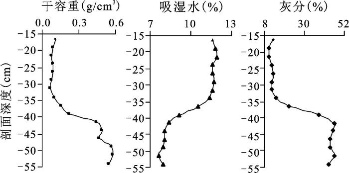
老白山剖面36.5 cm以上是泥炭藓泥炭,39 cm以下是草本泥炭为主的沉积物,中间是泥炭藓—草本混合层。老白山藓类泥炭的干容重变化在0.07~0.11 g/cm3,吸湿水含量为11%~12%,灰分含量为10%~15%;草本泥炭-沉积物的干容重变化在0.45~0.56 g/cm3,吸湿水含量为8.4%~7.7%,灰分含量为43.6%~46.5%;泥炭藓-草本泥炭的干容重变化在0.15~0.25 g/cm3,吸湿水含量为9.2%~11%,灰分含量为21.3%~27.7%(图2)。从地形地貌、泥炭残体类型、灰分含量、吸湿水、容重等性质揭示老白山上部36.5 cm已经发育成典型的贫营养泥炭沼泽,泥炭地养分只能依靠大气降水补给。
图2 老白山泥炭剖面干容重、吸湿水和灰分
Fig.2 Bulk density, moisture and ash content versus depth in Laobaishan peatland
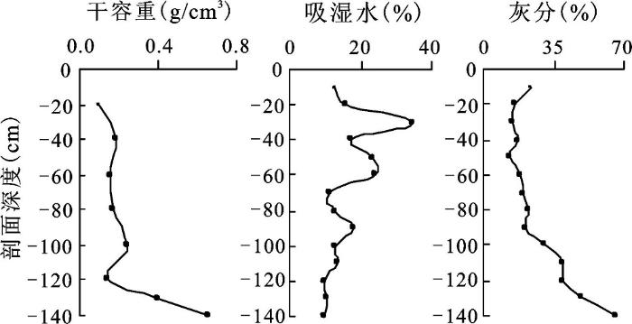
大桥泥炭剖面以苔草为主,褐色草本泥炭干容重变化在0.1~0.24 g/cm3,黑褐色草本泥炭容重为0.4~0.65 g/cm3。褐色泥炭灰分含量为13.5%~40%,黑褐色泥炭灰分含量是49.5%~65.5%。褐色泥炭吸湿水的含量变化在10%~34.75%,黑褐色泥炭在9.5%~10.25%(图3)。泥炭残体类型和泥炭性质表明,大桥泥炭地还处于富营养的发育阶段。
图3 大桥泥炭剖面干容重、吸湿水和灰分
Fig.3 Bulk density, moisture and ash content versus depth in Daqiao peatland
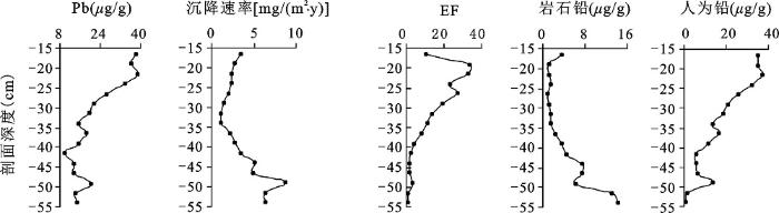
老白山剖面泥炭总铅含量在9.87~38.46 ug/g,平均值为21.87 ug/g。从剖面上看其含量随深度增加而减少,其中29 cm以上的铅浓度超过了下部的含量,并在剖面21.5 cm、36.5 cm和49 cm处出现峰值(图4)。
图4 老白山剖面泥炭记录的铅沉降
Fig. 4 Vertical distribution of concentration, accumulation rates and EF of total Pb, lithogenic Pb, atmospheric Pb in the Laobaishan peatland
相对于Zr元素,铅的富集因子表明,除剖面底部49~54 cm基本无富集外(相当于背景值),其余时间均有不同程度的富集,尤其到18世纪中期以后富集程度越来越大。
老百山剖面铅沉降速率为1.1~8.8 mg/(m2·y),在49 cm有明显一峰值,之后逐渐减小,直到29 cm后逐渐增加,但没有超过44 cm以下的沉降速率。
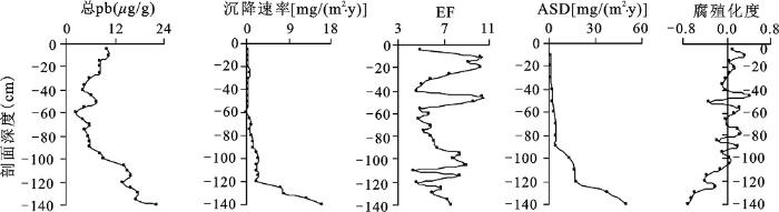
大桥泥炭剖面总铅含量变化在2.55~22.23 ug/g之间,平均值为9.42 ug/g,整体上比老白山低一点。剖面底部105~140 cm绝大多数铅含量在15~20 ug/g之间,向上逐渐减少,至表层0~10 cm略有增加(见图5)。
图5 大桥剖面泥炭记录的铅沉降与大气土壤灰尘输入速率和腐殖化度距平值
Fig. 5 Concentration, accumulation rates, EF of Pb, ASD and humification in Daqiao peatland
大桥剖面铅的富集因子在4.4~10.4,平均值为6.9,在底部135~140 cm、95~105 cm、45~50 cm和10~20 cm富集因子值较高。大桥铅的沉降速率变化范围较大[0.18~16.33 mg/(m2·y)],呈现出随着深度减小而变少的趋势。铅沉降速率的变化趋势与铅浓度非常近似(r=0.800,n=28,p<0.01)。
老白山剖面、大桥剖面与中国其他地区泥炭记录的铅含量和铅沉降速率基本在一个数量级上(表1)。整体上,从大兴安岭向老白山、大桥沿着西北-东南方向,总铅含量和沉降速率递减。而且,这几个地方泥炭记录的铅浓度都低于龙岗山脉小龙湾湖相沉积物中的结果[14],与欧洲瑞士Jura山脉泥炭沼泽中的铅含量相近[10,24],最大含量比德国、西班牙和比利时泥炭记录的值低一个数量级左右,铅的最大沉降速率也较比利时低一个数量级。
表1 研究区铅沉降与世界各地泥炭记录对比
Table 1 Comparison of concentration, accumulation rates of Pb in Dunhua and other areas
| 位置 | 平均含量(ug/g) | 含量范围(ug/g) | 沉降速率[mg/(m2·y)] | 累积时间 | 养分状况 | 出处 |
|---|---|---|---|---|---|---|
| 老白山剖面 | 21.87 | 9.87~38.46 | 1.1~8.8 | 1440~2002年 | 贫营养 | 本研究 |
| 大桥剖面 | 9.42 | 2.55~22.23 | 0.18~16.33 | 2120 B.P.以来 | 富营养 | 本研究 |
| 小龙湾 | 20~160 | 1875~2000年 | 湖相沉积 | Panizzo[14] | ||
| 汤洪岭 | 10.63 | 2~22.4 | 0.39~6.29 | 5200B.P.以来 | 贫营养 | 汤顺林[15] |
| 摩天岭MP1 | 14~110 | <68.9 | 1873~2008年 | 贫营养 | Bao[16] | |
| 摩天岭MP2 | 29~262 | <138.9 | 1838~2008年 | 贫营养 | Bao[16] | |
| 青藏高原 | 2.96~21.58 | 0.06~3.52 | 9500B.P.以来 | 贫营养 | Ferrat [17] | |
| 瑞士Jura 山脉 | 2.3~85.5 | 2110B.P.以来 | 贫营养 | Shotyk [24] | ||
| 瑞士Jura 山脉 | 15.4~29.6 | 自2700B.P. | 富营养 | Shotyk[25] | ||
| 德国 | 3300~1300 B.C. | 贫营养 | Roux[10] | |||
| 西班牙 | <3~118 | 自3000B.P. | 贫营养 | Gallego[9] | ||
| 比利时 | <660(孔1) <930(孔2) | <55(孔1) <140(孔2) | 550B.P.以来 | 贫营养 | Allan[11] |
老白山基底部49~54 cm总铅的沉降速率最大,但铅的富集因子显示底部既没有被消耗,也没有被富集,它意味着这部分铅主要来自于当地岩石或土壤的风化。为此,本文参照Shotyk提出的方法[25],使用Zr作为参考元素,估算通过气溶胶的大气沉降带来的岩石铅。
[Pb]岩石=[M]样品*([Pb]/[M])岩石 (2)
式中([Pb]/[M])岩石来自于地壳的平均组成[22],[M]为Zr元素的浓度。
岩石铅含量在剖面底部49~54 cm最大,超过10 ug/g,其余深度均小于这个数值,最低值相当于该值的1/10左右,且呈现从底部向上逐渐较少、直到表层又稍高一点的变化规律。
相关分析表明,岩石铅含量与铅沉降速率的变化趋势十分相似(r=0.804,n=16,p<0.01)。岩石铅和灰分的相关性也强(r=0.799,n=16,p<0.01),这在一定程度上指示了岩石铅主要来源于地壳岩石矿物的分解。
岩石Pb组成确定,外来的Pb很容易计算出:
[Pb]外来=[Pb]总-[Pb]岩石 (3)
外来铅剖面变化很大,背景值在0.8~1.2 ug/g,从底部向上逐渐增加,达到了背景值的5~37倍。老白山外来铅含量的变化趋势与总铅十分相似(r=0.956,n=16,p<0.01),说明外来铅在总铅中占主导位置。外来铅与富集因子变化趋势近似(r=0.874,n=16,p<0.01),表明铅的富集主要来源于风化之外的物质。总铅、外来铅都和有机质含量呈正相关(r分别为0.749和0.856,n=16,p<0.01),暗示外来的铅可能是被有机物、特别是泥炭藓强烈吸附,发生迁移的可能性很小。
贫营养泥炭养分只来自大气沉降,导致沉降在泥炭层内的外来铅相当于大气铅。老白山剖面大气铅的浓度从 1550~1582年间有所提高,然后一直到 1680年都呈下降的状态,之后,大气铅含量逐渐增高, 1712年左右达到一个峰值,短暂的下滑后,浓度越来越大,20世纪初期,已达到背景值的35倍左右,后期稍有下降。据此,可利用贫营养泥炭沼泽中的外来铅指示历史时期的大气沉降。分析铅污染的来源,16世纪的大气铅稍高可能与小冰期期间气温降低、灰尘增加有关;18世纪初的高含量似乎对应着1702年的一次火山活动[26];20世纪之后的污染,显然不是降尘的原因,而是和人类活动密切相关,清政府在1881年解除了对长白山地区的禁封,20世纪30年代日本人在长白山地区采伐森林,以及新中国成立后的大力建设等这些人类活动都带来了铅的人为污染。
与老白山剖面相比,大桥剖面更倾向于富营养化。除了泥炭残体中苔草占绝对优势、泥炭理化性质呈现富营养特点外,大桥剖面泥炭pH在4.0~5.5之间,Al和Ti含量之间没有相关性,Sr与灰分含量不对应,大多数的Ca随着深度增加而增大,这些意味着剖面物质可能存在着沉积后的化学溶解或受地下水影响,但剖面泥炭的Ca/Mg却小于或等于当地雨水[20]。
总铅、铅沉降速率都是基底部为极大值,向上递减,到表层又增加。这样的剖面分布规律意味着可能发生了沉积后的再迁移。但富集因子却显示,最大值出现在亚表层,基底部的富集因子偏小,这一现象似乎表明,铅在剖面上的迁移相对较弱。
本文参考Ferrat使用的方法[27],略作修改,计算了大桥泥炭地大气土壤灰尘输入速率的历史变化,计算公式为,
ASD=Ti/0.4%×ρ×AR/100 (4)
式中,ASD表示大气土壤灰尘输入速率[g/(m2·y)],Ti是样品中元素Ti的含量(ug/g),Ti/0.4%相当于泥炭中土壤降尘的浓度,ρ是泥炭密度(g/cm3),AR是泥炭累积速率(cm/y)。
计算结果显示,大桥剖面大气土壤灰尘输入速率变化在0.93~50.12 g/(m2·y),平均为11.45 g/(m2·y),这个数值与鲍锟山计算的长白山区外源土壤尘埃的大气输入速率一致[28]。总体上,大桥剖面大气土壤灰尘输入速率随剖面向上递减(图5),其变化趋势与总铅、铅沉降速率的发展趋势一致,相关分析表明,大气灰尘输入速率与总铅浓度呈明显的正相关(r=0.908,n=14, p<0.01),与铅的沉降速率也呈明显的正相关(r=0.952,n=14,p<0.01),即剖面底部铅浓度高、沉降速率大与大气土壤灰尘输入速率显著相关。而大气灰尘输入速率与腐殖化度呈明显的负相关,即灰尘输入速率大的时期,腐殖化度低(r=-0.830,n=14,p<0.01),分解较弱。由此可以初步判断,大桥剖面铅的再沉积和再移动较弱,因此可以从铅沉积来重建大气土壤灰尘输入速率,这一点与Shotyk的结论一致。
大桥剖面铅浓度和铅沉降速率峰值均出现在2120 a B.P.,铅的富集因子揭示大约1898 a B.P.、1720~1809 a B.P.、1057~1175 a B.P.和235~470 a B.P.间铅富集程度较重,这些时段的铅富集都远在当地的工业革命之前,相对当地人为活动而言,更有可能是远方大气携带而来。腐殖化度的分析证明在约1765~1809 a B.P.、约1057 a B.P.和约1480~1715 年期间气候偏干。巧合的是,最近的铅富集时间235 a B.P.(相当于1715年)在老白山剖面也有所体现,而2120 a B.P.的铅浓度和铅流峰值在瑞士Jura山脉泥炭记录中也有所表现[5]。
大桥剖面总铅含量整体上小于老白山剖面,可能是大桥剖面年代相对老,当时的铅污染相对较轻;另一种可能与其海拔比老白山低、反应环境变化不够敏感有关;还有可能的原因是,东亚冬季风从西北方向带来了远方的灰尘,首先在老白山沉降,至大桥剖面时已减弱,而大兴安岭总铅和沉降速率都高于小兴安岭、老白山和大桥,似乎也符合这一规律。实际的结果也可能是上述几种可能的复合。
敦化地区贫营养泥炭和富营养泥炭记录的铅浓度、铅沉降速率与中国其他地区泥炭记录的结果在同一个数量级上,整体上贫营养泥炭地老白山剖面记录的铅浓度高于富营养泥炭地大桥剖面记录的含量。富集因子与外来的大气铅呈明显的正相关,表明铅的富集主要来源于大气沉降。大气铅在总铅中占主导地位,并与有机质呈明显的正相关,揭示其很可能被泥炭藓等有机物质吸附,而没有发生较大的移动。据大气铅富集因子在剖面的变化情况,推测本区在小冰期期间大气降尘量大,18世纪初期铅的峰值可能与当地的火山喷发有关,而20世纪后的铅污染是人类活动的结果。
大桥剖面富集因子最大值出现在亚表层,基底部的富集因子偏小,这一现象似乎表明,铅在剖面上的迁移相对较弱。而且,剖面上总铅浓度、铅沉降速率随着深度增加而增大,这一点与大气土壤输入速率呈明显的正相关。由此可以推断,大桥泥炭记录的铅在剖面上再移动或再沉积较弱,可以用其重建当时的大气沉降。
The authors have declared that no competing interests exist.
| [1] |
Archives of atmospheric Pb pollution [J].https://doi.org/10.1007/s001140050612 URL [本文引用: 1] 摘要
Environmental archives such as peat bogs, sediments, corals, trees, polar ice, plant material from herbarium collections, and human tissue material have greatly helped to assess both ancient and recent atmospheric lead deposition and its sources on a regional and global scale. In Europe detectable atmospheric lead pollution began as early as 6000years ago due to enhanced soil dust and agricultural activities, as studies of peat bogs reveal. Increased lead emissions during ancient Greek and Roman times have been recorded and identified in many long-term archives such as lake sediments in Sweden, ice cores in Greenland, and peat bogs in Spain, Switzerland, the United Kingdom, and the Netherlands. For the period since the Industrial Revolution, other archives such as corals, trees, and herbarium collections provide similar chronologies of atmospheric lead pollution, with periods of enhanced lead deposition occurring at the turn of the century and since 1950. The main sources have been industry, including coal burning, ferrous and nonferrous smelting, and open waste incineration until c.1950 and leaded gasoline use since 1950. The greatest lead emissions to the atmosphere all over Europe occurred between 1950 and 1980 due to traffic exhaust. A marked drop in atmospheric lead fluxes found in most archives since the 1980s has been attributed to the phasing out of leaded gasoline. The isotope ratios of lead in the various archives show qualitatively similar temporal changes, for example, the immediate response to the introduction and phasing out of leaded gasoline. Isotope studies largely confirm source assessments based on lead emission inventories and allow the contributions of various anthropogenic sources to be calculated.
|
| [2] |
Two thousand years of atmospheric arsenic, antimony, and lead deposition recorded in an ombrotrophic peat bog profile,Jura Mountains,Switzerland [J]. |
| [3] |
Summary of the workshop on peat bog archives of atmospheric metal deposition [J].https://doi.org/10.1023/A:1018336828640 URL 摘要
No Abstract
|
| [4] |
Sphagnum mosses as archives of recent and past atmospheric lead deposition in Switzerland [J].https://doi.org/10.1016/S1352-2310(99)00093-X URL [本文引用: 1] 摘要
Sphagnum mosses received from a herbarium and collected recently from a peat bog surface, were used to assess the isotopic character of past and recent atmospheric Pb deposition in Switzerland and to constrain possible Pb sources. Lead removed from the moss surface was isotopically similar to that measured in the corresponding solid plant, suggesting that neither preservative actions for the herbarium samples nor dust had affected the isotopic composition of the samples. The addition of HCl to aqueous extracts to remove surface particles from the plants released more Pb compared to H 2 O alone. The changes in isotope ratios between Sphagnum collected during the past c. 130聽yr were significantly greater than the small fluctuations between and among species collected at any one time. Three isotope ratio plots and emission inventories indicated that the most likely source of atmospheric Pb was coal-burning at the turn of the century, fly ash from waste incineration until approximately 1950, and gasoline combustion after that. The pollution record derived from the Sphagnum plants is in good agreement with other archives from Switzerland (peat, sediment, ice) and with other herbarium records in Europe.
|
| [5] |
History of atmospheric Lead deposition since 12,370 14C yr BP from a peat bog, Jura Mountains, Switzerland [J].https://doi.org/10.1126/science.281.5383.1635 URL PMID: 9733502 [本文引用: 2] 摘要
A continuous record of atmospheric lead since 12,370 carbon-14 years before the present ( 14 C yr BP) is preserved in a Swiss peat bog. Enhanced fluxes caused by climate changes reached their maxima 10,590 14 C yr BP (Younger Dryas) and 8230 14 C yr BP. Soil erosion caused by forest clearing and agricultural tillage increased lead deposition after 5320 14 C yr BP. Increasing lead/scandium and decreasing lead-206/lead-207 beginning 3000 14 C yr BP indicate the beginning of lead pollution from mining and smelting, and anthropogenic sources have dominated lead emissions ever since. The greatest lead flux (15.7 milligrams per square meter per year in A.D. 1979) was 1570 times the natural, background value (0.01 milligram per square meter per year from 8030 to 5320 14 C yr BP).
|
| [6] |
Mobility and diagenesis of Pb and 210Pb in peat [J].https://doi.org/10.1016/0016-7037(90)90288-V URL [本文引用: 1] 摘要
ABSTRACT Peatlands long have been considered to preserve the record of atmospheric deposition of anthropogenic contaminants such as Pb. In the past two decades, Â05¹°Pb has been widely used to data recent strata of peat and to calculate accumulation rates. The assumption that Pb and Â05¹°Pb are immobile and not subject to diagenesis in peat has been questioned but not rigorously tested. The authors attempted to determine if Pb is mobile in peatlands and if Pb profiles are altered by diagenic processes by constructing a mass balance for Pb about a small peatland, by comparing inventories, concentrations, and accumulation rates of Pb and Â05¹°Pb in peatlands across northeastern North America, and by examining the relationship between concentrations of Pb in bog waters and peat in numerous sites. The results clearly demonstrate that Pb and Â05¹°Pb are mobilized by the organic-rich waters of peatlands. Profiles of Pb and Â05¹°Pb at depths below the water table do not preserve the record of atmospheric deposition, and inventories of Pb and Â05¹°Pb are depleted in peatland hollows. Concentrations of Pb in bog waters are regulated by the concentration of Pb in the peat and the concentration of dissolved organic carbon. The mass balance for one bog indicated that over the specific three-year period of study more than 30% of inputs of Pb were not retained within the peat. As a result of this mobility, dates based on Â05¹°Pb can be biased and inaccurate by as much as 30 years. Dates based on Â05¹°Pb should be verified by other techniques, especially when the inventory of Â05¹°Pb is less than that expected from local rates of deposition.
|
| [7] |
Distributions, inventories and isotopic composition of lead in 210Pb-dated peat cores from contrasting biogeochemical environments: Implications for lead mobility [J].https://doi.org/10.1016/S0048-9697(98)00302-7 URL [本文引用: 1] 摘要
The use of concentration profiles of lead and other contaminant metals in 210 Pb-dated ombrotrophic peat cores for reconstruction of historical trends in atmospheric deposition has become relatively well established. However, uncertainty remains over the validity of the assumption of post-depositional immobility of lead in peats. In particular, a number of studies have suggested that in saturated peat systems, lead is subject to diagenetic remobilisation and redistribution, with the result that 210 Pb and lead profiles do not provide a historical record of deposition. Results are presented here for lead concentrations, inventories and stable isotope ratios and for 210 Pb activities in two peat cores from locations close to the Glasgow industrial area in west-central Scotland. Contrasting biogeochemical conditions prevailed at the two sampling sites, with one being unsaturated and ombrotrophic while the other was saturated and minerotrophic. The results for the ombrotrophic peat core were compatible with information from other peat and lake sediment core studies, data for archived herbage samples and with known historical trends both in industrial activity and in the use of lead as an additive to petrol, giving a high degree of confidence in the 210 Pb chronology and implied record of deposition. This provides strong support for the suggestion that lead is immobile in such systems. In contrast, the lead concentration profile and stable isotope data for the minerotrophic peat provided apparent temporal variations that were inconsistent with other studies and known historical trends, confirming that the saturated peat core did not provide a record of atmospheric deposition. This observation is consistent with the suggestion that lead is subject to diagenetic remobilisation and redistribution in saturated peats.
|
| [8] |
The chronology of anthropogenic, atmospheric Pb deposition recorder by peat cores in three minerogenic peat deposits from Switzerland [J].https://doi.org/10.1016/S0048-9697(02)00030-X URL PMID: 12108442 [本文引用: 1] 摘要
Peat cores were collected from three minerogenic peatlands in: La Tourbi猫re des Genevez (), in Canton Jura; Gola di Lago (GDL), in Canton Ticino; and Mauntschas (MAU), in Canton Grisons. Chemical analyses of the and the peats document the increasingly minerogenic character with depth. In particular, the Sr concentration profile in the peats reflects the growing importance of sediment dissolution with increasing distance below the peat surface. Despite this circumstance, Pb concentrations are greatest in the surface layers, and decrease with depth. Thus, dissolution of the basal sediments at these sites appears to be an unimportant source of Pb, compared with atmospheric deposition. Twenty-one new radiocarbon age dates for the three cores provide a chronology of Pb enrichment, and these are consistent with the record of atmospheric Pb deposition recorded by the ombrotrophic peat bog 'Etang de la Gru猫re' (EGR). Sediment samples from and EGR were reacted at pH 5 with to dissolve the carbonate fraction, filtered, and the residues analyzed using XRF. These analyses show that much of the Ca, Mg, Sr and Mn is lost when the carbonate fraction is dissolved, but this process does not measurably affect Pb. This finding suggests that carbonate dissolution dominates the weathering of the sediments underlying these peat deposits, but this fraction does not contain significant concentrations of Pb. Minerogenic peat deposits such as those described here, therefore, can serve as reliable archives of atmospheric Pb deposition, provided that dissolution in the underlying sediments does not contribute measurably to the Pb inventory of the peat profile.
|
| [9] |
Multivariate study of trace element distribution in the geological record of Roñanzas Peat Bog (Asturias, N. Spain). Paleoenvironmental evolution and human activities over the last 8000 cal yr BP [J]. |
| [10] |
Recent atmospheric Pb deposition at a rural site in southern Germany assessed using a peat core and snowpack, and comparison with other archives [J].https://doi.org/10.1016/j.atmosenv.2005.07.026 URL Magsci [本文引用: 1] 摘要
In a peat bog from Black Forest, Southern Germany, the rate of atmospheric Pb accumulation was quantified using a peat core dated by 210 Pb and 14 C. The most recent Pb accumulation rate (2.5mgm 612 y 611 ) is similar to that obtained from a snowpack on the bog surface, which was sampled during the winter 2002 (1 to 4mgm 612 y 611 ). The Pb accumulation rates recorded by the peat during the last 25yr are also in agreement with published values of direct atmospheric fluxes in Black Forest. These values are 50 to 200 times greater than the “natural” average background rate of atmospheric Pb accumulation (20μgm 612 y 611 ) obtained using peat samples from the same bog dating from 3300 to 1300cal. yr B.C. The isotopic composition of Pb was measured in both the modern and ancient peat samples as well as in the snow samples, and clearly shows that recent inputs are dominated by anthropogenic Pb. The chronology and isotopic composition of atmospheric Pb accumulation recorded by the peat from the Black Forest is similar to the chronologies reported earlier using peat cores from various peat bogs as well as herbarium samples of Sphagnum and point to a common Pb source to the region for the past 150 years. In contrast, Pb contamination occurring before 1850 in southwestern Germany, differs from the record published for Switzerland mainly due to the mining activity in Black Forest. Taken together, the results show that peat cores from ombrotrophic bogs can yield accurate records of atmospheric Pb deposition, provided that the cores are carefully collected, handled, prepared, and analysed using appropriate methods.
|
| [11] |
High-resolution reconstruction of atmospheric deposition of trace metals and metalloids since AD 1400 recorded by ombrotrophic peat cores in Hautes-Fagnes, Belgium [J].https://doi.org/10.1016/j.envpol.2013.03.018 URL PMID: 23619507 Magsci [本文引用: 1] 摘要
The objective of our study was to determine the trace metal accumulation rates in the Misten bog, Hautes-Fagnes, Belgium, and assess these in relation to established histories of atmospheric emissions from anthropogenic sources. To address these aims we analyzed trace metals and metalloids (Pb, Cu, Ni, As, Sb, Cr, Co, V, Cd and Zn), as well as Pb isotopes, using XRF, Q-ICP-MS and MC-ICP-MS, respectively in two 40-cm peat sections, spanning the last 600 yr. The temporal increase of metal fluxes from the inception of the Industrial Revolution to the present varies by a factor of 5-50, with peak values found between AD 1930 and 1990. A cluster analysis combined with Pb isotopic composition allows the identification of the main sources of Pb and by inference of the other metals, which indicates that coal consumption and metallurgical activities were the predominant sources of pollution during the last 600 years. (c) 2013 Elsevier Ltd. All rights reserved.
|
| [12] |
偏远地区铅和汞的现代过程与历史记录研究综述 [J].https://doi.org/10.11821/xb201003010 URL Magsci [本文引用: 1] 摘要
人类活动释放的重金属(尤其是铅和汞)通过大气等介质的长距离传输,导致了全球环境的污染和损害,因而一直是环境科学研究的热点。为了认识重金属的污染程度、全球传输以及生物地球化学循环过程,急需在偏远的背景地区开展深入研究。本文概述了目前通过冰芯和湖泊沉积恢复重金属污染历史的研究成果,以及与背景地区大气重金属现代过程相关的研究进展,分析了存在的科学问题,探讨了青藏高原在开展该方面的研究、特别是综合集成研究上的独厚区域优势。而高原野外台站的建立(如纳木错多圈层综合观测研究站)也为此类研究的实施提供了可靠的后勤保障。
|
| [13] |
土壤铅污染研究进展 [J].https://doi.org/10.3969/j.issn.1004-1184.2011.01.025 URL [本文引用: 1] 摘要
随着工业化和城市化进程的加 速,土壤铅污染问题日趋严峻。本文简要回顾了近几十年来公路两侧土壤铅污染、城市土壤铅污染以及污灌区土壤铅污染的现状调查,并介绍了土壤中铅的化学形态 提取方法的发展过程。此外,还简要介绍了各种土壤对铅的吸附特性及影响吸附的因素。指出铅的各种化学形态在包气带垂向上的迁移转化机理研究将是今后铅的环 境地球化学行为研究的一个主要方向。
|
| [14] |
Recent palaeolimnological change recorded in Lake Xiaolongwan, northeast China: Climatic versus anthropogenic forcing [J].https://doi.org/10.1016/j.quaint.2012.07.033 URL [本文引用: 2] 摘要
Not Available
|
| [15] |
小兴安岭雨养型泥炭记录的大气铅沉降及与气候变化的响应研究 [J].https://doi.org/10.3969/j.issn.1673-9787.2010.03.023 URL [本文引用: 1] 摘要
采用原子吸收光谱仪,对小兴安岭汤洪岭雨养型泥炭中的铅进行了测定,结合前人的定年工作,获 得了小兴安岭地区近5000a来大气铅沉降及与气候变化的响应关系.研究结果表明,小兴安岭雨养型泥炭剖面中大气铅的沉降通量与区域气候变化有着良好的响 应关系.5200~2800aBP的铅沉降通量较大,这与全新世大暖期后的气候温暖湿润有利于大气铅的沉降密切相关,该时期大气铅沉降清晰地显示了2次强 降温事件.2800—350aBP的铅沉降通量较低,且波动起伏较大,与中国大暖期结束,气候转变为冷湿,不利于大气铅的沉降密切相关.距今350a以来 的大气铅沉降通量较大,与近代工业革命和该区域金属冶炼等关系密切.
|
| [16] |
Recent atmospheric lead deposition recorded in an ombrotrophic peat bog of Great Hinggan Mountains, Northeast China, from 210Pb and 137Cs dating [J].https://doi.org/10.1016/j.jenvrad.2010.05.004 URL PMID: 20621757 摘要
Radioactive markers are useful in dating lead deposition patterns from industrialization in peat archive. Peat cores were collected in an ombrotrophic peat bog in the Great Hinggan Mountains in Northeast China in September 2008 and dated using (210)Pb and (137)Cs radiometric techniques. The in both cores were examined systematically for dry bulk density, water and ash content. Lead also was measured using atomic emission spectroscopy with inductively coupled plasma (-). Both patterned peat profiles were preserved well without evident anthropogenic disturbance. Unsupported (210)Pb and (137)Cs decreased with the depth in both of the two sample cores. The (210)Pb chronologies were established using the constant rate of supply model () and are in good agreement with the (137)Cs time marker. Recent atmospheric (210)Pb flux in Great Hinggan Mountains peat bog was estimated to be 337 Bq m(-2)y(-1), which is consistent with published data for the region. Lead deposition rate in this region was also derived from these two peat cores and ranged from 24.6 to 55.8 mg m(-2)y(-1) with a range of Pb concentration of 14-262 microg g(-1). The Pb deposition patterns were consistent with increasing industrialization over the last 135-170 y, with a peak of production and coal burning in the last 50 y in Northeast China. This work presents a first estimation of atmospheric Pb deposition rate in peatlands in China and suggests an increasing trend of environmental pollution due to anthropogenic contaminants in the atmosphere. More attention should be paid to current local pollution problems, and society should take actions to seek a balance between economic and environmental protection.
|
| [17] |
Lead atmospheric deposition rates and isotopic trends in Asian dust during the last 9.5 kyr recorded in an ombrotrophic peat bog on the eastern Qinghai-Tibetan Plateau [J].https://doi.org/10.1016/j.gca.2010.10.031 URL [本文引用: 2] 摘要
A full understanding of the atmospheric Pb cycle in Asia during the Holocene is key to palaeoclimate studies of past atmospheric circulation patterns, as well as to assess the impact of increasing industrial activities in this region. However, long-term records of atmospheric Pb isotopic trends in Asia are still sparse. Consequently, we study changes in the concentrations, fluxes and isotopic signature of deposited Pb contained in a C-dated peat core from the eastern Qinghai-Tibetan Plateau, dating back to 9.5 kyr BP, and present the first peat record of the changing isotopic composition of atmospheric Pb in dust in Asia during this time. Lead concentrations and fluxes vary between 2.96-21.58 渭g gand 0.06-3.52 mg my, respectively, with an average Pb baseline of 6.80 卤 4.18 渭g g. These values agree with other Pb studies of lake and peat archives in China but are one order of magnitude larger than early and mid-Holocene values measured in Europe. Lead isotopic variability throughout the core is small, varying between Pb/Pb = 1.190-1.197, Pb/Pb = 18.648-18.786, Pb/Pb = 15.666-15.694 and Pb/Pb = 38.890-39.090. The application of Bayesian trans-dimensional changepoint modelling to the Pb dataset enabled the identification of eight significant changes in the isotopic composition of the deposited Pb. Such changes mark different phases of atmospheric Pb deposition, and hence variations in atmospheric circulation patterns and environmental conditions. Temporal variations in the potential natural and/or anthropogenic Pb sources are assessed based on the Pb, Pb, Pb and Pb isotopic composition and the 1/[Pb] ratio of the peat samples. Our results suggest that Pb deposition throughout the Holocene was governed by local deposition and long-range input from natural dust sources in northwestern (Taklamakan desert and Qaidam basin) and northern China (Badain Jaran and Tengger deserts). Input from the northern sources seems to have been particularly important between 3.1-2.7 kyr BP and 1.7-0.9 kyr BP, suggesting a possible strengthening of the East Asian winter monsoon, in agreement with previous reconstructions in Asia. Based on the Pb/Sc and isotopic composition profiles we do not note any evidence for anthropogenic Pb derived from the thriving mining or smelting activities in northern and eastern China in the last few millennia, suggesting that atmospheric deposition to this region of the eastern Tibetan Plateau was dominated by natural Pb fluxes. These can serve as a true Asian "background" value against which anthropogenic impacts can be quantified. Our results confirm that the combination of radiogenic isotopes (Pb) and trace elements in peat bogs enables observational reconstructions of changes in past regional atmospheric circulation. Such records will enable more refined interpretations of marine and terrestrial palaeorecords in Asia and the Pacific and consequently provide further constraints for changes in ocean and atmospheric circulation and for the testing of palaeoclimate models of circulation patterns.
|
| [18] |
黄泥河自然保护区老白山南坡植被垂直带谱及其特点 [J].https://doi.org/10.3969/j.issn.1008-2786.2003.01.012 URL [本文引用: 1] 摘要
老白山南坡植被垂直分异现象明显,可划分为5个植被垂直带:蒙古 栎阔叶林带、红松阔叶混交林带、鱼鳞云杉暗针叶林带、岳桦林带和偃松林带.由于山体小、下部受人为干扰以及上部被多条沟谷切割,故植被垂直带较窄.山体上 部因受沟谷切割,加之分布冰缘地貌石河以及部分植物种具有较强的适应性,所以造成垂直带谱的破碎化.山顶冷湿,地势平坦、发育有沼泽.老白山比长白山白头 山纬度高2°,海拔低995 m,植被垂直带谱比其多一个偃松带;老白山比大兴安岭英吉里山纬度低7°,海拔高236m,植被垂直带谱比其多一个岳桦林带,说明老白山植被垂直带谱具有 从温带向寒带过渡的特点.
|
| [19] |
吉林省敦化地区晚全新世泥炭沼泽孢粉组合特征及古植被 [J].
对大桥泥炭地的孢粉进行了分析和年龄测定.根据孢粉组合、地层特征和14c年龄将剖面划分为4个孢粉带,分别为2195±70~2045±70yrb.p.松为主的松-云冷杉-榛-栎-苔草组合带、2045±70~1745±70yrb.p.苔草为主的松-桦-榛埠桃-苔草组合带、1745±70~705±70yrb.p.松-榛-鹅耳枥-苔草-毛茛组合带和705±70yrb.p.~1950yra.d.松-云冷杉-桦-苔草组合带.周围植被由温带山地针叶林(类似现今海拔1100m以上)、温带针阔混交林下部(类似现今海拔400~600m)和温带针阔混交林中部(类似现今海拔600~800m)过渡到温带针阔混交林上部(类似现今海拔800~1100m).相应地,泥炭沼泽经历了孕育期、蓬勃发展期、继续扩张期和消亡期.
|
| [20] |
长白山地区全新世泥炭剖面地球化学特征及其古地理意义 [J].https://doi.org/10.7605/gdlxb.2004.03.010 Magsci [本文引用: 3] 摘要
<p>长白山地区是中国泥炭分布集中地区之一。本文选择长白山地区典型的泥炭剖面——大桥剖面,探讨其沉积物常量元素和微量元素的垂直分布规律及其对全新世气候变化的指示作用,并与该区另一代表剖面——金川泥炭剖面进行对比。结果表明,泥炭中常量元素含量最大值出现在195 cm,向上、向下都减少,铁含量与灰分、容重在剖面上的变化规律基本一致,说明它主要来源于灰分;由于泥炭和砂土的基本性质,如容重、灰分、pH值有很大的区别,泥炭层微量元素大于下部砂土的含量,亚表层微量元素含量最高,这与灰分、纤维含量正好相反,与pH值剖面变化一致;沉积物容重、灰分、pH值、Ca/ Mg以及元素的富集因子、泥炭中总碳含量在剖面上的变化,显示很强的一致性,据此反映该区经历了早11880~7600aBP)、中(7 600~480aBP)、晚(2480~0aBP)全新世三个环境阶段,其结论与前人通过孢粉、同位素手段分析得到的金川泥炭剖面环境变迁规律相同,从而说明它们可以作为研究环境变迁的敏感指标。</p>
|
| [21] |
Chambers F M,Beilman D W,Yu Z.Methods for determining peat humification and for quantifying peat bulk density, organic matter and carbon content for palaeostudies of climate and peatland carbon dynamics [OL].Mires and Peat,2011,7 (Article07):1-10[ |
| [22] |
The composition of the continental crust [J].https://doi.org/10.1029/95JB00191 URL [本文引用: 2] 摘要
A new calculation of the crustal composition is based on the proportions of upper crust (UC) to felsic lower crust (FLC) to mafic lower crust (MLC) of about 1:0.6:0.4. These proportions are derived from a 3000 km long refraction seismic profile through western Europe (EGT) comprising 60% old shield and 40% younger fold belt area with about 40 km average Moho depth. A granodioritic bulk composition of the UC in major elements and thirty-two minor and trace elements was calculated from the Canadian Shield data (Shaw et al., 1967, 1976). The computed abundance of thirty-three additional trace elements in the UC is based on the following proportions of major rock units derived from mapping: 14% sedimentary rocks, 25% granites, 20% granodiorites, 5% tonalites, 6% gabbros, and 30% gneisses and mica schists. The composition of FLC and MLC in major and thirty-six minor and trace elements is calculated from data on felsic granulite terrains and mafic xenoliths, respectively, compiled by Rudnick and Presper (1990). More than thirty additional trace element abundances in FLC and MLC were computed or estimated from literature data. The bulk continental crust has a tonalitic and not a dioritic composition with distinctly higher concentrations of incompatible elements including the heat producing isotopes in our calculation. A dioritic bulk crust was suggested by Taylor and McLennan (1985). The amount of tonalite in the crust requires partial melting of mafic rocks with about 100 km thickness (compared with about 7 km in the present MLC) and water supply from dehydrated slabs and mafic intrusions. At the relatively low temperatures of old crustal segments MLC was partly converted into eclogite which could be recycled into the upper mantle under favourable tectonic conditions. The chemical fractionation of UC against FLC + MLC was caused by granitoidal partial melts and by mantle degassing which has controlled weathering and accumulation of volatile compounds close to the Earth's surface.
|
| [23] |
Piotrowska N,Blaauw M,Mauquoy D,et al.Constructing deposition chronologies for peatd eposits using radiocarbon dating [OL]. Mires and Peat, 2011,7(Article 10):1-14[ |
| [24] |
Geochemistry of the peat bog at Etang de la Gruère, Jura Mountains, Switzerland, and its record of atmospheric Pb and lithogenic trace metals (Sc, Ti, Y, Zr, and REE) since 12,370 14C yr B.P. [J]. |
| [25] |
A new approach for quantifying cumulative, anthropogenic, atmospheric lead deposition using peat cores from bogs: Pb in eight Swiss peat bogs profiles [J].https://doi.org/10.1016/S0048-9697(99)00523-9 URL PMID: 10813459 [本文引用: 1] 摘要
Abstract Peat cores taken from eight Swiss peatlands were used to calculate inventories of anthropogenic Pb using either Sc or Zr to quantify Pb derived from rock weathering. The shapes of the Pb/Sc and Pb/Zr profiles suggest that Pb was supplied exclusively by atmospheric deposition at all sites. At one of the sites (Etang de la Gru猫re), anthropogenic Pb was calculated using both Sc and Zr as the conservative reference element. Lithogenic Pb determined using Sc was twice that obtained using Zr, possibly because Zr resides only in zircons which are dense compared to pyroxene and amphibole which are the main Sc-bearing phases in the earth's crust. However, the inventory of 'natural' Pb (supplied almost entirely by soil dust) is dwarfed by the anthropogenic inventory such that anthropogenic Pb calculated using Sc and Zr agree to within 5%. The total amount of anthropogenic Pb accumulated in the bogs was calculated by simply adding the mass of anthropogenic Pb for each peat slice over the length of each core. Cumulative, anthropogenic Pb calculated in this way ranged from 1.0 to 9.7 g/m2 and showed pronounced regional differences: the site south of the Alps (Gola di Lago in Canton Ticino) with direct exposure to the heavily industrialized region of northern Italy received nearly 10 times more anthropogenic Pb as the sites in more remote alpine regions (Sch枚pfenwaldmoor in Canton Berne, and Mauntschas in Canton Grisons). The approach used here to calculate cumulative, anthropogenic, atmospheric Pb (CAAPb) is simple and robust, independent of the chronology of Pb deposition, and makes no assumptions about the immobility of Pb within the peat profile. Given the worldwide distribution of peat bogs, it should be possible to undertake continental and global inventories of atmospheric metal deposition, for both the natural and anthropogenic components of most trace metals of environmental interest.
|
| [26] |
火山干扰下的长白山植被分布规律 [J].
距今约800 a前,长白山天池火山发生大规模普林尼式喷发,喷出的巨量火山浮石及火山灰毁灭性地破坏了长白山植被。由于受喷发倾角和强劲高空西北风影响,使各坡向火山灰和浮石的沉积厚度不同,东坡最厚,南坡和西坡次之,北坡最少。火山灰与浮石形成疏松的成土母质,在流水持续侵蚀下,对破坏后的植被演替产生了长期影响。利用野外调查和现有资料,论证了长白山植被分布独特性规律是长白山火山喷发及喷发物水蚀过程对生态系统作用的结果,确认火山喷发虽历经800多a,目前各坡向植被仍然处在演替的不同进程之中,呈现差异性分布规律。
|
| [27] |
The inorganic geochemistry of a peat deposit on the eastern Qinghai-Tibetan Plateau and insights into changing atmospheric circulation in central Asia during the Holocene [J].https://doi.org/10.1016/j.gca.2012.05.028 URL [本文引用: 1] 摘要
Peat records enable the reconstruction of changes in the global biogeochemical mineral dust cycle and the detection of variations in atmospheric circulation patterns during the Holocene. They can therefore provide a key tool for understanding the relationship between the geochemical dust cycle and past climate change. Here, we present the first detailed study of the inorganic geochemistry of a peat core collected at an altitude of 3500 m from the Hongyuan peatland, on the eastern Qinghai-Tibetan Plateau, and test its potential as an archive of atmospheric dust deposition. We find that the low accumulation rates of the peat and the presence of the extensive dust sources of northern China in the vicinity of the study site lead to approximately five times higher concentrations of mineral matter compared to temperate ombrotrophic peats. A detailed geochemical assessment of the core and surface samples from local and non-local dust sources, as well as of the hydrology and hydrochemistry of the surrounding waters, suggests that external and internal post-depositional processes have not affected the record of lithogenic elements, including the rare earth elements (REE), Sc, Y and Th. Changes in Ti-normalized major element profiles, La/Yb, Y/Tb and the Eu anomaly identify seven major shifts among the dominant dust sources and therefore potential changes in atmospheric circulation patterns. Bivariate plots using the REE-based tracers La/Yb, Y/Tb, La/Th, Y/Er, Sc/La, Th/Sc and Th/危REE suggest that the Taklamakan desert and the Chinese loess plateau in northern China were the dominant non-local dust sources to the peat. Local dust input dominated throughout the early Holocene until 4.9 kyr BP. Increased dust input from the non-local sources thereafter suggests an enhanced influence of winds associated with the East Asian winter monsoon and the Westerly jet throughout most of the late Holocene. Sharp increases in non-local dust fluxes between 3.1-2.7 and between 1.3-0.9 kyr BP suggest a particular strengthening of these wind systems during these times, in agreement with the organic characteristics of the core. Our results show that the Hongyuan peat is a reliable archive to study dust deposition in central Asia and allows the identification of changes in atmospheric circulation patterns and in the larger climatic arrangements of the monsoon system in this region during the Holocene.
|
| [28] |
东北山地泥炭沼泽沉积及其记录的近200年环境变化[D] . |

/
| 〈 |
|
〉 |