陈利顶 , 贾福岩
, 贾福岩
CHEN Li-ding, JIA Fu-yan
中图分类号: X144
文献标识码: A
文章编号: 1000-0690(2015)09-1176-07
收稿日期: 2014-08-3
修回日期: 2014-10-12
网络出版日期: 2015-09-25
版权声明: 2015 《地理科学》编辑部 本文是开放获取期刊文献,在以下情况下可以自由使用:学术研究、学术交流、科研教学等,但不允许用于商业目的.
基金资助:
作者简介:
作者简介:陈利顶(1965-),男,河南辉县人,研究员,主要从事景观生态学、土地利用变化的环境效应和生态保护方面研究。E-mail: liding@rcees.ac.cn
展开
摘要
以位于陕北黄土丘陵区的羊圈沟流域为重点研究区,针对不同坡面类型(坡长、坡形、坡度)和植被组合进行野外土壤采样,利用137Cs元素示踪方法评估坡面的土壤侵蚀效应。研究发现:① 坡面形态对土壤侵蚀具有重要影响。自坡顶至坡脚,“直-凹”组合的坡型一般具有相对较低的土壤侵蚀模数,整体上起到“汇”的作用;但“凹-直/凸”组合的坡型具有相对较高的土壤侵蚀模数,在土壤侵蚀方面起到“源”的作用;其他坡型,如直坡、凸坡、“直-凸”和复杂性坡型的土壤侵蚀模数介于两者之间。② 坡面不同植被空间配置对土壤侵蚀的影响具有明显差异。研究发现,坡面植被组合(自坡顶至坡脚)为荒草地-果园、有林地-其他植被类型组合和荒草地-其他植被类型的坡面具有相对较低的土壤侵蚀模数,起到了一定“汇”的功能,但人为干扰较为强烈的景观坡面(无水土保持措施)具有相对较高的土壤侵蚀模数,整体上表现为土壤侵蚀的“源”区。
关键词:
Abstract
Land use/land cover and slope configuration are important factors affecting soil erosion in the gully and hilly area of the Loess Plateau. However, most work conducted in China against soil erosion in the loess plateau mainly focused on vegetation restoration, and few of them is concerned with the influences of slope configuration and vegetation combination along the slope transacts. The combination of the slope forms and vegetation patterns in the hill-slopes may give rise to different results to the soil erosion process, to be a source or a sink. It is, to great extent, determined by the slope configuration, the position of vegetation on the hill slope, as well as their combination. In this study, the effects of slope configuration and vegetation pattern on soil erosion in the loess hill-slope were explored by using 137Cs isotope method and extensively field sampling in Yangquangou catchment of the Northern Shaanxi Province. In total, 118 sampling sites in 25 slope profiles are selected, and these slopes are classified into 6 types according to the configuration and 8 groups based on the vegetation patterns. The results show that: 1) Slope configuration will have significant impacts on soil erosion. In general, the slope configuration with straight form in the upper hill-slope and concave form in the lower hill-slope may have the lowest soil erosion modus, which will become a sink in term of soil erosion as a whole. However, the slope configuration with concave form in the upper hill-slope and straight/convex form in the lower hill-slope has the highest soil erosion modus. This slope may function as a source in term of soil erosion. The soil erosion effects of the other slope configurations fall in between the above two slope configurations. 2) Much difference exists on soil erosion regarding to different vegetation patterns on the loess hill-slope. It was found that the loess hill-slope with wild grassland or woodland in the upper hill-slope and orchard or other vegetation types in the lower hill-slope may have the lowest erosion modus, which plays as a sink in terms of soil erosion from the whole slope. However, the slope with strong human disturbance, for example the sloping farmland, will have the highest soil erosion modus, which plays as the source of soil erosion as a whole. 3) For controlling soil erosion, planting mature forests and grasses in the upper and middle position of loess hill-slope may remarkably reduce the overall soil erosion and sediment yields in the entire watershed. The results are valuable for land-use pattern optimization in the loess hill-slope by identifying the potential risky area of soil erosion in both slope configurations and vegetation patterns. And also, it is helpful for sustainable land use planning and ecosystem management at catchment in the loess plateau.
Keywords:
随着黄土高原地区大面积生态退耕,水土流失在较大程度上得到了控制,但由此带来的生态系统服务效应,既有正面的,也有负面的。植被恢复的水土流失效应到底如何?特别是坡面上不同植被的空间配置对水土流失过程的影响,目前还缺乏科学的共识。现有的研究多是基于径流观测实验,或者降雨模拟实验研究[1]。在降雨模拟实验方面,更多的是针对单一类型,从植被格局配置方面开展的模拟实验研究相对较少,如卫伟等基于微型径流小区的降雨模拟实验,定量研究了自然坡面上不同植株微观格局的水土流失效应,认为坡面植被配置上,沙棘位于下坡位时的水土保持效果最好[2]。字淑慧等选用非洲狗尾草、高羊茅和红三叶3种牧草,在云南昆明王家箐流域的坡耕地上进行了混播草带防治水土流失效应的研究[3]。流域尺度土地利用变化的水土流失效应研究,更多的是基于模型的定量评价。如赵文武等基于土地利用数据和双累积曲线方法,研究了陕北杏河集水区1985和1995年土地利用格局变化的水土流失效应[4]; Yang等利用泥沙输移分布模型模拟了岷江上游黑水流域和镇江关流域的侵蚀量、产沙量的空间分布特征,并利用景观空间负荷对比指数分析了土地利用/覆被类型随空间要素配置、贡献权重和组成比例对土壤侵蚀的影响[5]。
基于“源-汇”动态平衡研究生态学过程,国内外学者也开展了大量研究。相对而言,国外学者更多的是从动植物迁移过程出发,探讨景观格局与生物保护的关系[6~9];国内学者从水土流失和环境污染角度,探讨土地利用变化与水土流失、养分流失之间的关系[5,10~13]。李海防等[14]利用“源-汇”景观格局指数,研究了甘肃定西关川河流域退耕还林(草)过程中土地利用变化的土壤侵蚀效应。吴运军应用改进的简单土地利用结构特征指标,分析了乌苏里江流域近50 a来土地利用结构变化对水土流失的影响[15]。胡文帙等从格局-过程-尺度和“源-汇”景观角度,应用稳定同位素和放射性核素示踪方法,研究了土地利用演变及其土壤侵蚀特征[16];高光耀等分析了植被斑块、坡面覆被格局对水土流失的影响,认为植被类型、层次结构和形态特征是植被斑块尺度上影响径流泥沙的关键因素,其主要原因是改变了径流泥沙运移和汇集的路径[17]。但基于定量方法研究流域尺度坡型和植被空间配置对水土流失效应的影响工作相对较少。汪亚峰等基于137Cs元素示踪方法,研究了黄土丘陵沟壑区羊圈沟小流域土壤侵蚀强度的演变特征[18]。水土流失过程受到了多种因素影响,不仅与土地利用方式或植被类型有关,也与土壤性质、坡面形态、坡度等因素密切相关[1,19,20]。本文基于137Cs元素示踪方法,定量分析了坡面尺度植被空间配置、坡型组合的土壤侵蚀的“源”“汇”效应。
研究地区羊圈沟小流域位于延安市宝塔区李渠镇辖区,为延河左岸二级支沟,地理坐标为36°42′N,109°31′E,流域面积2.0 km2(图1)。该区属于半干旱半湿润大陆性季风气候,多年平均降水量535 mm,降水多集中在7~9月,年际变率大;年平均气温9.4℃,7月平均气温22.9℃,1月平均气温-6.5℃,≥0℃的活动积温为3 100~3 878℃,≥10℃活动积温为2 500~3 400℃,平均无霜期140~165 d,农作物为一年一熟制。
图1 研究区地理位置与土壤采样布分布
Fig.1 The location of the study area and soil sampling sites
该区属黄土丘陵沟壑区第二副区,土壤主要为黄绵土,在区划上植被属于森林草原过渡带。由于人为干扰,自然植被破坏殆尽,多为人工种植而形成的次生植被。主要树种有刺槐(Robinia pseudoacacia)、柳树(Salix spp.)和杨树(Poplar spp.)等。阳坡和半阳坡主要分布着艾蒿(Wormwood)+长芒草群丛(Long awn)、白羊草(Bothriochloa ischaemum)+艾蒿群丛、白羊草+达乌里胡枝子群丛(Leguminosae)、长芒草+达乌里胡枝子+翻白草群丛,阴坡和半阴坡主要分布着铁杆蒿+茭蒿群丛(Artemisia L.)。土地利用类型有灌木林地、乔木林地、果园、荒草地、梯田耕地、坝地农田、水域和居民用地等。果园树种为杏树、苹果和核桃。主要农作物有谷子(Setaria italica)、玉米(Zea may)、大豆(Glycine max)、糜子(Panicum miliaceum)、土豆(Solanum tuberosum)。
本文利用137Cs元素示踪方法研究了坡面及其植被空间配置的土壤侵蚀效应。依据土地利用类型和土壤断面布设采样点,兼顾不同坡形;同时在不同坡面的3个坡位上都尽量保证有采样点。土壤采样用荷兰Eijkelkamp公司生产的直径6 cm半圆凿型土钻。本研究选取的背景参考点均匀分布于流域坡顶和梁峁坡部位,土地利用类型为荒草地和林地,通过计算所有点监测值的平均值作为背景值。全流域采样点118个,采样深度30 cm,其中分层样105个(其中包括20个参考点),分0~5、5~10、10~20、20~30 cm共4层,全样(即直接采集0~30 cm深度的土壤)13个均为坡面典型格局的样点。每个样点由沿等高线方向的采样点的土样混合组成;样品带回实验室风干,磨碎过2 mm筛,并称重。土壤137Cs测定在中国科学院生态环境研究中心城市与区域生态国家重点实验室的放射性仪器室进行,利用ORTEC公司生产的8192道低本底γ能谱仪在661.62 keV处测定137Cs全能峰净面积,测量时间>28 800 s,测量相对误差<15%(置信度95%),比活度由标准源相对比较法得到。
考虑到该区域50 a来土地利用以耕种为主,只是在20世纪80年代初种植林草水保措施,而且当时这些林草地所占面积不大,直到2000年流域内才实施大规模退耕还林。因此,选用农耕地侵蚀模型计算土壤侵蚀量[18,21]。
式中,
基于地形图和野外坡面采样点位置,表1首先分析坡面的形态特征(自坡顶至坡脚),并根据不同坡位植被类型分布特征,分析了坡面植被类型空间组合特征,同时结合地形图和野外观测结果,对坡面坡度进行了定性分析。
表1 羊圈沟流域典型剖面基本特征
Table 1 Basic characteristics of typical hill-slope in Yangjuangou catchment
| 要素景观剖面 | 剖面基本信息(坡顶至坡脚) | |||
|---|---|---|---|---|
| 坡面土壤采样点 | 坡面形态特征(自坡顶至坡脚) | 植被类型特征 | 坡度 | |
| 剖面1 | 点2-1-3 | 凹-直-凸 | Gw-Gw-Gw | 陡-中-缓 |
| 剖面2 | 点6-5-4 | 凸-凸-凸 | Ws-Ws-Gw | 中-中-中 |
| 剖面3 | 点9-8-7 | 直-凹-直 | Ws-Ws-Gw | 陡-陡-中 |
| 剖面4 | 点11-12-14-13 | 直-凸-直-直 | Ws-Ws-Gw-Ws | 陡-中-中-中 |
| 剖面5 | 点20-21 | 凸-凸 | Gw-Gw | 缓-中 |
| 剖面6 | 点23-24-22 | 凸-直-凸 | Gw-Ww-Ww | 缓-中-中 |
| 剖面7 | 点25-26-27 | 凸-凹-凸 | Gw-Ww-Ww | 中-中-缓 |
| 剖面8 | 点29-30-32-33 | 直-凹-凸-直 | Gw-Gw-Od-Od | 缓-陡-缓-中 |
| 剖面9 | 点36-37-38-39 | 凸-直-凹-凸 | Ww-Ww-Gw-Ww | 中-陡-陡-陡 |
| 剖面10 | 点19-18-17-16 | 凸-直-直-凸 | Ww-Ws-Ww-Gw | 缓-中-中-中 |
| 剖面11 | 点19-44-43 | 凸-凹-直 | Ww-Ww-Gw | 缓-陡-陡 |
| 剖面12 | 点47-46-45 | 凸-凹-直 | Gw-Gw-Ww | 缓-中-中 |
| 剖面13 | 点55-56 | 直-直 | Ww-Ww | 中-陡 |
| 剖面14 | 点53-52 | 凸-凸 | Gw-Ww | 中-中 |
| 剖面15 | 点51-50-49 | 凸-凸 | Ww-Ww-Ws | 缓-缓-中 |
| 剖面16 | 点64-63-62 | 直-直-凸 | Gw-Ww-Ww | 陡-中-中 |
| 剖面17 | 点69-68-67 | 直-凹-凸 | Ww-Ww-Gw | 陡-中-中 |
| 剖面18 | 点70-71-72 | 直-凸-凸 | Ww-Ww-Gw | 中-陡-缓 |
| 剖面19 | 点75-74 | 直-直 | Gw-Ww | 中-中 |
| 剖面20 | 点73-76-77 | 凸-直-凸 | Gw-Gw-Ws | 缓-中-陡 |
| 剖面21 | 点81-82 | 直-直 | Ws-Ws | 中-中 |
| 剖面22 | 点83-86 | 直-直 | Gw-Ws | 陡-陡 |
| 剖面23 | 点90-91-92 | 直-直-凸 | Ww-Gw-Gw | 陡-陡-缓 |
| 剖面24 | 点95-94-93 | 凸-凸 | Ww-Ww-Ww | 缓-缓-缓 |
| 剖面25 | 点96-97 | 凸-凸 | Ww-Od | 中-缓 |
基于土壤采样的137Cs元素测定结果,根据上述剖面特征,进一步分析不同剖面20 cm表层土壤的年土壤流失厚度和土壤侵蚀模数(表2),由此可以进一步揭示剖面形态及其植被空间组合在土壤侵蚀方面的“源”“汇”效应。
表2 羊圈沟流域典型剖面20 cm表层土壤侵蚀基本特征
Table 2 Soil erosion features of typical hill-slope in Yangjuangou catchment
| 要素景观剖面 | 年流失厚度(mm) | 侵蚀模数[t/(km2·a)] | ||||||
|---|---|---|---|---|---|---|---|---|
| 点1 | 点2 | 点3 | 点4 | 点1 | 点2 | 点3 | 点4 | |
| 剖面1 | 5.20 | 3.80 | 6.50 | 5895.0 | 4299.0 | 7338.0 | ||
| 剖面2 | 10.80 | 10.40 | 3.20 | 12181.0 | 11715.0 | 3579.0 | ||
| 剖面3 | 8.50 | 9.40 | 2.50 | 9544.0 | 10622.0 | 2830.0 | ||
| 剖面4 | 7.00 | 7.90 | 4.00 | 12.60 | 7918.0 | 8911.0 | 4523.0 | 14168.0 |
| 剖面5 | 5.90 | 6.40 | 6622.0 | 7144.0 | ||||
| 剖面6 | 7.50 | 7.80 | 5.20 | 8394.0 | 8722.0 | 5846.0 | ||
| 剖面7 | 5.90 | 0.80 | 4.00 | 6662.0 | 904.0 | 4526.0 | ||
| 剖面8 | 3.50 | 5.40 | 2.20 | 4.50 | 3888.0 | 6038.0 | 2429.0 | 5100.0 |
| 剖面9 | 3.50 | 2.20 | 4.70 | 1.50 | 3960.0 | 2439.0 | 5343.0 | 1681.0 |
| 剖面10 | 4.30 | 5.10 | 5.70 | 3.60 | 4799.0 | 5703.0 | 6382.0 | 4097.0 |
| 剖面11 | 4.30 | 1.20 | 1.30 | 4799.0 | 1375.0 | 1424.0 | ||
| 剖面12 | 3.80 | 3.80 | 1.20 | 4274.0 | 4268.0 | 1401.0 | ||
| 剖面13 | 5.00 | 3.80 | 5649.0 | 4261.0 | ||||
| 剖面14 | 7.10 | 2.80 | 7983.0 | 3184.0 | ||||
| 剖面15 | 0.60 | 2.30 | 0.30 | 713.0 | 2583.0 | 283.0 | ||
| 剖面16 | 2.30 | 3.60 | 1.10 | 2546.0 | 4047.0 | 1293.0 | ||
| 剖面17 | 3.40 | 10.70 | -0.60 | 3850.0 | 12071.0 | -696.0 | ||
| 剖面18 | 2.40 | 3.10 | 4.80 | 2679.0 | 3541.0 | 5424.0 | ||
| 剖面19 | 2.00 | 4.00 | 2246.0 | 4454.0 | ||||
| 剖面20 | 4.40 | 2.80 | 4.70 | 4926.0 | 3098.0 | 5305.0 | ||
| 剖面21 | 6.90 | 4.50 | 7714.0 | 5023.0 | ||||
| 剖面22 | 3.30 | 9.20 | 3731.0 | 10331.0 | ||||
| 剖面23 | 9.80 | 8.80 | 3.90 | 11016.0 | 9906.0 | 4367.0 | ||
| 剖面24 | 6.90 | 6.70 | 6.50 | 7813.0 | 7564.0 | 7259.0 | ||
| 剖面25 | 3.80 | 7.50 | 4314.0 | 8436.0 | ||||
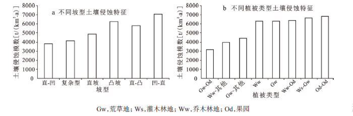
图2 黄土丘陵区不同坡面类型和植被空间配置的土壤侵蚀特征
Fig. 2 Comparison on soil erosion among different slope configurations and vegetation patterns in Yangjuangou catchment
基于表1和表2,从坡面形态和坡面植被组合分析土壤侵蚀的“源”“汇”效应。研究发现,① 坡面形态特征对土壤侵蚀具有重要影响。自坡顶至坡脚,“直-凹”组合的坡型具有相对较低的土壤侵蚀模数,在土壤侵蚀方面,起到一定的截留作用,具有相对较强的“汇”的功能;但“凹-直”组合的坡型具有相对较高的土壤侵蚀模数,从坡面尺度看,是土壤侵蚀的重要“源”;其他坡型,如直坡、凸坡、“直-凸”和复杂性坡型的土壤侵蚀模数往往介于两者之间,由此可以看出,不同形态的坡面在土壤侵蚀方面的“源”“汇”作用具有差异(图2a)。② 坡面植被空间配置对土壤侵蚀的影响具有明显差异。自坡顶至坡脚,坡面植被组合为荒草地-果园、有林地-其他植被类型组合和荒草地-其他植被类型的坡面具有相对较低的土壤侵蚀模数。而人工干扰较为明显的坡面植被组合类型具有相对较高的土壤侵蚀模数;人工干扰对土壤侵蚀的影响取决于干扰的目的和性质;基于水土保持的人为干扰,如坡改梯工程、植物篱工程,可以起到降低土壤侵蚀的作用;但一般意义的耕作可以促进土壤侵蚀过程(图2b)。
在土壤侵蚀的定量模拟研究中,多是基于径流小区的模拟结果;基于野外大面积采样分析,定量探讨坡面形态对土壤侵蚀过程的影响,目前开展的工作相对较少。阎百兴和汤洁、方华军等基于137Cs元素示踪分析结果,定量比较了黑土地区不同坡位对土壤侵蚀的影响,发现坡面的不同部位对土壤侵蚀的影响有明显差异[22,23];刘宝元等领导的团队,通过在中国东北黑土地区设置径流观测,定量研究不同坡长、坡度和地表覆盖类型对土壤侵蚀过程的影响[24]。基于137Cs元素示踪分析方法的结果显示,在黄土高原地区直-凹坡型(自坡顶至坡脚)的坡面具有较低的土壤侵蚀模数,而凹–直坡型具有相对较高的土壤侵蚀模数。这是因为,对于直-凹坡型,直坡具有较强的汇水作用,但是其位于坡的上部位;下坡位的凹型坡具有较强的截留能力,可以有效地截留来自于上坡位的土壤侵蚀,使得整个坡面起到了“汇”的作用。反观凹-直坡型,由于坡面上部为凹型,坡面下部为直型坡,凹型坡土壤侵蚀的截留功能未能达到有效发挥,由此使得该类坡型在整体上表现出较强“源”的作用;直-凹组合的坡面在整体上表现出相对较强“汇”的作用,具有较好的水土保持功能。
坡面植被类型空间配置不同在水土保持方面具有的效果也不同。土地利用的空间镶嵌特征变化能够改变坡面的水文结构和侵蚀系统,引起土地利用(如地块边界)对土壤流失拦截能力的降低或提高,进而影响到最终流域产沙量的增加或减少[25,26]。Bedford和Small研究新墨西哥中部地区坡面-冲积扇断面土壤生态水文属性的空间格局,发现植被空间格局决定了土壤属性的空间格局[27]。Ludwig等研究干旱半干旱区植被镶嵌斑块和径流-侵蚀的相互影响,表明坡面水沙的局部再分布归因于现有的植被镶嵌格局[28]。Puigdefabregas的研究也得到相似的结果[29]。Bautista等认为在干旱半干旱区,植被空间格局对生态水文过程具有重要作用,指出斑块密度和径流间存在负相关关系,比较植被格局和径流产沙、土壤属性的关系,前者的关系表现的更加显著[30],坡面(自坡顶至坡脚)为林地-坡耕地-草地结构的坡面具有较好的养分和水土保持功能[31]。
研究发现,坡面(自坡顶至坡脚)植被组合为荒草地-果园、有林地-其他植被类型和荒草地-其他植被类型的坡面具有相对较低的土壤侵蚀模数。这就说明,坡顶或上部受到的干扰越小,相对产生的土壤侵蚀就会较小;反之,如果坡面上部受到了人为干扰,地表土壤和植被会受到较多的破坏和松动,由此会产生较多的土壤侵蚀。从植被特征和土壤侵蚀“源”和“汇”角度出发,可以认为,若具有相对较强“源”功能的植被类型分布在坡面的中下部时,常常会导致严重的土壤侵蚀。当具有较强“汇”功能的植被类型分布在坡面下部时,常常会起到水土保持的作用,截留来自上部的土壤侵蚀,起到“汇”的作用。
坡面植被空间配置的水土保持效应一直是黄土高原地区植被恢复与水土保持关注的重要课题。虽然开展了许多研究工作,但更多的是基于径流小区观测或降雨模拟实验结果,由此所获得的认识与实际情况常常存在较大差异。本文基于137Cs元素示踪方法,通过野外大面积采样分析,研究了坡面形态、坡面植被空间组合在土壤侵蚀方面的“源”“汇”效应。研究发现,坡顶至坡脚表现为“直-凹”组合的坡型,与“凹-直/凸”组合的坡型相比,在土壤侵蚀方面表现出较强的“汇”功能,而“凹-直/凸”组合的坡型更容易产生土壤侵蚀;在坡面植被组合(自坡顶至坡脚)方面,当具有较强截留作用的植被类型位于坡面上部时,而坡面下部分布为具有较强土壤侵蚀的植被类型时,往往具有较差的水土保持作用,整体上这样的坡面表现为土壤侵蚀“源”。研究结果对于客观认识坡面形态、坡面植被空间配置在土壤侵蚀方面的作用,为在土壤侵蚀模型中如何刻画坡面形态、植被空间配置的影响提供了重要参考依据。
The authors have declared that no competing interests exist.
| [1] |
坡面土壤侵蚀过程研究进展 [J].https://doi.org/10.3969/j.issn.1000-0690.2003.02.017 URL [本文引用: 2] 摘要
基于土壤侵蚀发生方式 ,重点评述了坡面雨滴溅蚀、薄层水流侵蚀、细沟侵蚀和浅沟侵蚀的研究进展 ,指出了各自研究中存在的问题 ,并提出坡面侵蚀过程中亟待加强的研究领域
|
| [2] |
黄土丘陵区坡面水蚀对降雨和下垫面微观格局的响应 [J]. |
| [3] |
混播草带防治坡耕地水土流失效应的研究 [J].
为有效防治坡耕地水土流失,提高坡耕地持续利用,于2001~2002年选用非洲狗尾草、高羊茅和红三叶3种优良牧草,在云南昆明王家箐流域的坡耕地上进行了混播草带防治水土流失效应的研究。试验设混播非洲狗尾草与红三叶(A)、混播高羊茅与红三叶(B)、单播高羊茅(C)和无草带种植(D)4个处理,坡度在13.2°~14°之间;每个处理坡耕地上部等高种植9 m×2 m玉米,基部种植0.5 m宽的草带,底部设径流收集池。结果表明:选择适宜草种进行混播,所形成的草带水土保持效果优于单播草带;在雨季(5~10月)4个处理的水土流失量为D>C>B>A,与对照D相比,处理A、B、C的径流量分别减少了79.19%、64.02%和51.53%,侵蚀量分别减少了92.04%、84.49%和78.70%;混播豆科和禾本科牧草,有利于增加草带的总盖度和草层高度,促进根系生长,增强草带的水土保持效果。
|
| [4] |
黄土丘陵沟壑区集水区土地利用格局变化的水土流失效应 [J].https://doi.org/10.3321/j.issn:1000-0933.2004.07.008 URL Magsci [本文引用: 1] 摘要
以陕北杏河集水区 1 985和 1 995年两期土地利用数据为基础 ,结合水文、DEM数据 ,定性分析了土地利用格局变化条件下的水土流失效应 ,其中采用双累积曲线法来界定土地利用格局基本没有变化的时间段 ,用 C值在坡度、距河流距离上的分布来表征土地利用格局 ,用不同时期降雨量 /径流量、降雨侵蚀力 /输沙率相对增加的比例来表征水土流失效应。研究结果表明 :(1 ) 1 981~ 2 0 0 0年 ,土地利用格局变化剧烈的年份为 1 990~ 1 991年 ,可以用 1 985、1 995年两期数据分别代表 2 0世纪 80年代和90年代的土地利用 ;(2 )从 2 0世纪 80年代到 90年代 ,杏河集水区的 C值有明显的增加趋势 ,在较陡坡度和距河流距离较近处 ,C值增加的幅度相对较大 ;(3)土地利用格局变化明显改变了降雨量 -径流量、降雨侵蚀力 -输沙率的关系 ,出现了从 2 0世纪80年代到 90年代 ,虽然降雨量 /降雨侵蚀力在整体上呈现明显下降的趋势 ,但是水土流失量 ,却表现出同比增加的现象 ,而且这种增加在不同月份也有差异。用本文中的方法来表征土地利用格局和水土流失效应 ,其结果具有较好的比配性,可以用来定性分析土地利用格局与水土流失的关系。但是,由于水土流失效应的表征方法没有考虑降雨的空间变异特征,该方法尚不适于雨量站点比较密集、降雨空间变异较大的区域。此外,在进一步的研究中,还需要注间遥感数据解译的准确性、C值精度、土地条件的变化等问题。
|
| [5] |
Assessing effects of landscape pattern on sediment yield using sediment delivery distributed model and a landscape indicator [J].https://doi.org/10.1016/j.ecolind.2011.08.023 URL [本文引用: 2] 摘要
The rationale behind this research concerns the need to better understand relationships between landscape pattern and soil loss processes. Landscape indicators are commonly used to delineate these relationships. However, most indicators were not developed on the basis of soil loss progresses, and therefore their specific relationships with soil loss are difficult to construct. We improved the Location-weighted landscape Contrast Index which was developed based on sediment source鈥搒ink theory. This indicator encompasses three factors of landscape pattern: contribution of land cover types to soil erosion; composition and configuration of land covers. To analyze correlations between the landscape indicator and soil loss processes, variables expressing soil loss status should be first quantified. Therefore we applied the sediment delivery distributed model which incorporates revised universal soil loss equation (RUSLE) and sediment delivery ratio. The methods were applied in the Heishui and Zhenjiangguan subwatershed in the Upper Min River. Modeling results showed that 90% of the study area experienced soil erosion larger than 10t/(hayr). While its sediment yield rate was smaller than most tributaries in the Upper Yangtze River. Results of Pearson correlation analysis indicated that the rainfall factor in RUSLE was the dominant control and explained 93% of variance in sediment yield rate. We suggested preserving and increasing percentage cover of forests to adapt to climate change for soil conservation. Besides precipitation, landscape pattern was a principle factor correlated with sediment yield rate. The landscape indicator was significantly correlated to sediment delivery ratio, and explained 98% variation in sediment yield rate not considering precipitation by dropping the rainfall factor. The landscape indicator indicated that the landscape pattern was generally favorable for soil conservation in the two subwatersheds. This advantage was mainly ascribed to superior sediment sink鈥搒ource compositions. In the Heishui subwatershed, however, sediment source contributed more to soil erosion processes than sink. Spatial configuration of sediment source and sink related to flow length were the most unfavorable factor, mainly due to the crops located in river vallyes. We gave suggestion to further optimize the landscape pattern: reducing percentage cover of grasslands with high soil erosion rate; decreasing soil erosion rate of sediment source in the Heishui subwatershed; increasing lengths of flow path from crops to river channels.
|
| [6] |
Analyzing wildfire exposure and source-sink relationships on a fire prone forest landscape [J]. |
| [7] |
Remnant grassland habitats as source communities for plant diversification in agricultural landscapes [J].https://doi.org/10.1016/j.biocon.2007.09.016 URL 摘要
Lately there has been a shift in Sweden from grazing species-rich semi-natural grasslands towards grazing ex-arable fields in the modern agricultural landscape. These fields normally contain a fraction of the plant species richness compared to semi-natural grasslands. However, small remnant habitats have been suggested as important for plant species diversity and conservation as they may function as refugia for grassland specialists in fragmented and highly modified agricultural landscapes. In this study, we examined whether plant communities on small remnant habitats, i.e. midfield islets, can function as sources for grassland species to disperse out into surrounding grazed ex-fields (former arable fields). We examined species richness and grassland specialists (species favoured by grazing) and their ability to colonize fields after 5 and 11 years of grazing. The fields that had been grazed for a shorter time were fairly species-poor with few grassland specialists. A longer period of grazing had a positive effect on total and small-scale species diversity in both islets and fields. Species composition became more similar with time, and the number of grassland specialists in both habitats increased. We found that grassland specialists dispersed step-wise into the fields, and the number of grassland specialists decreased with distance from the source. Our study suggests that remnant habitats, such as midfield islets, do function as a source community for grassland specialists and enhance diversification of grassland species when grazing is introduced. For long-term conservation of plant species, incorporating small refugia into larger grazing complexes may thus enhance species richness.
|
| [8] |
Landscape pattern and productivity effects on source-sink dynamics of deer populations [J]. |
| [9] |
Analysis of landscape sources and sinks: the effect of spatial pattern on avian demography [J].https://doi.org/10.1016/S0006-3207(00)00209-3 URL [本文引用: 1] 摘要
To develop theoretical insights into the relationship between spatial pattern and demography, we coupled a spatially structured demographic model with neutral landscape models to investigate how landscape structure affected population persistence and the source–sink potential of landscapes for a generalized, territorial migratory songbird. Four species-types, with different sensitivities to habitat area and edge effects, were simulated on replicated landscapes across a range of habitat abundance (1–90%) and fragmentation or spatial contagion (random, fractal with minimal contagion, and fractal with maximum contagion). For each species-type in each landscape, the expected number of female offspring produced per female (fecundity, b ) was modeled as an explicit function of habitat area and spatial structure (patch edge-to-area ratio). Fecundity estimates ( b ) were combined with survivorship in a life-table analysis to estimate the net lifetime reproductive output ( R 0 ) for the population of each landscape. Landscapes for which R 0 <1 were identified as population sinks, and as potential population sources when R 0 >1. As expected, reproductive output ( R 0 ) was generally highest on fractal landscapes with maximum clumping (minimum fragmentation) and lowest on random landscapes (maximum fragmentation), especially for species with high edge sensitivity. For species with low edge sensitivity, population persistence was unlikely when the landscape had <40% habitat (i.e. R 0 <1.0 in these landscapes and were population sinks). Thus, thresholds in population persistence could be identified for different species in these landscapes, but the level of habitat required for persistence ranged widely from 5 to 90% depending upon the species’ response to habitat fragmentation (edge sensitivity) and the specific landscape pattern. Our results caution against the adoption of general rules or ‘cookbook prescriptions’ in conservation regarding the amount of habitat required for population persistence (e.g. the ‘20% rule’). Landscape configuration (the ‘details of how habitat is arranged’) can mitigate the effects of habitat loss and enhance population persistence in fragmented landscapes.
|
| [10] |
基于“源-汇”生态过程的长江上游农业非点源污染研究 [J].
景观空间格局是农业非点源污染的主要影响因素之一,关于二者的相互关系缺乏定量研究。针对长江上游的农业非点源污染问题,应用基于“源-汇”生态过程理论提出的景观空间负荷对比指数,选取9个典型的行政单元,探讨了长江上游流域景观空间格局和非点源污染之间的定量关系。结果表明,景观空间负荷对比指数对非点源污染负荷有显著的响应关系,说明景观空间负荷对比指数可作为非点源污染空间风险评价的有用方法之一。在此基础上,进一步分析了长江上游典型行政单元景观空间负荷对比指数时空演变规律。探讨了指数演变时空差异原因,认为该指数主要受到区域景观的坡度、与污染出口相对距离、高程、土地利用类型比重和农业与农村经济政策的影响。最后提出了长江上游非点源污染空间风险控制与管理的对策。
|
| [11] |
基于“源”“汇”景观格局指数的海河流域总氮流失评价 [J].URL 摘要
土地利用类型及其格局能够影响非点源污染时空特征,而景观格局分析方法是评价非点源污染的重要技术手段,但是传统的景观格局指数较少考虑景观之间的位置关系,导致生态意义不明确."源""汇"景观格局理论中的"源景观"和"汇景观"指的是促进和阻碍非点源污染发生的景观类型.通过收集海河流域2009年夏季26个子流域的总氮浓度数据,并结合1∶25万DEM和1∶10万土地利用图,构建了融合景观类型、面积、空间位置等信息在内的源汇景观格局指数,发现源汇景观格局指数与总氮浓度有很好的相关性,在燕山山区、太行山区和下游平原区的相关系数分别为0.86、0.67和0.65.结果表明,源汇景观格局指数能够很大程度上反映总氮...
|
| [12] |
137Cs示踪技术在黑土区农业非点源污染负荷研究中的应用 [J].Magsci 摘要
利用<sup>137</sup>Cs核素示踪和定位监测相结合,研究松嫩平原黑土区3个旱作坡面土壤的流失厚度和流失速率,坡面土壤流失厚度1.20~5.25 mm/a,侵蚀强度1 355.0~7 558.2 t/(km<sup>2</sup>·a);近40 a来,松嫩平原黑土区年均入河(湖)农业非点源污染负荷分别为TN 1.43 t/(km<sup>2</sup>·a)、NH<sub>3</sub><sup>-</sup>N 15.01 kg/(km<sup>2</sup>·a)、NO<sub>3</sub><sup>-</sup>N 8.51 kg/(km<sup>2</sup>·a)TP 0.42 t/(km<sup>2</sup>·a)、PO<sub>4</sub><sup>3-</sup>-P 1.85 kg/(km<sup>2</sup>·a);土壤流失氮以有机氮为主;水溶态无机氮占总氮的0.51%,水溶性磷酸盐磷占总磷的0.12%。黑土区农业非点源污染物的输出和水土流失密切相关,深入研究其输移机理及防治措施具有重要的环境意义。
|
| [13] |
A method to analyze “source-sink” structure of non-point source pollution based on remote sensing technology [J]. |
| [14] |
基于“源”“汇”景观指数的定西关川河流域土壤水蚀研究 [J].https://doi.org/10.5846/stxb201212191821 Magsci [本文引用: 1] 摘要
基于"源-汇"理论,利用"源""汇"景观指数分析方法,计算甘肃定西关川河流域1995年、2000年、2005年和2010年的"源""汇"景观指数(LWLI,Location-weighted landscape index),对比分析"源""汇"景观空间格局变化与土壤水蚀的关系。结果表明:(1)关川河流域从1995年到2010年的LWLI<sub>elevation</sub>、LWLI<sub>distance</sub>和LWLI<sub>slope</sub>指数呈降低的趋势。在高海拔和距流域出水口较远的区域,"源"景观的贡献逐渐小于"汇"景观的贡献。林地主要分布在坡度较小的地区,而草地主要分布在坡度较大地区。(2)"源""汇"景观综合指数LWLI从1995年到2005年持续下降,但2010年的LWLI值比2005年又有所提高,说明由于地区人口的扩大和自然资源的限制,某些地区农地扩张的压力依然很大。(3)20年间流域大气降水没有发生显著变化,但河川径流量、径流系数和土壤侵蚀模数逐年减少。LWLI与土壤侵蚀模数(<em>P</em><0.05)具有显著正相关关系。LWLI能够较好地反映流域土壤水蚀规律,可作为流域水土流失评价的有效方法。对深入探讨黄土高原"退耕还林还草"工程与流域水文过程的关系,有效控制水土流失,优化黄土高原的治理,具有重要的理论和实践意义。
|
| [15] |
基于土地利用结构的乌苏里江水土流失效应分析 [J].
探讨基于乌苏里江流域土地利用结构变化对乌苏里江界河的水土流失的影响,无疑对于乌苏里江界河的国土防护具有极其重要的意义。本文以地形图、MSS和TM影像数据提取乌苏里江流域1954年、1976年和2000年土地利用结构信息。应用一个改进型的土地利用结构的特征指标,分析了乌苏里江流域近50年来土地利用结构变化对于乌苏里江的水土流失的影响。近50年来,由于以沼泽地为代表的水土保持权重值高的地类面积日益缩小、破碎化程度呈增高趋势,而旱地等低权重值地类面积迅速扩张、连通性增强,改进型土地利用结构特征指标呈下降趋势,3个时期的指标值分别是18.21937、9.72415、2.57338,表明近50年来乌苏里江流域的土地利用结构变化朝不利于乌苏里江界河的水土保持发展,乌苏里江界河承受日益增大的水土流失危险性。
|
| [16] |
喀斯特峰丛洼地土地利用演变及其土壤侵蚀效应 [J]. |
| [17] |
干旱半干旱区坡面覆被格局的水土流失效应研究进展 [J].https://doi.org/10.5846/stxb201111051675 URL [本文引用: 1] 摘要
植被恢复与建设是控制水土流失 的重要措施。在干旱半干旱地区,植被在空间上的分布呈现离散特征,在坡面上形成的裸地-植被镶嵌和植被条带分布等覆被格局对水土流失过程具有重要影响。覆 被格局与水土流失关系研究是景观生态学格局与过程研究的重要内容。从植被斑块、坡面覆被格局对水土流失的影响与耦合覆被格局与水土流失的手段和方法三个方 面对国内外相关研究进行总结分析。从中发现,植被类型、层次结构和形态特征是植被斑块尺度上影响径流泥沙的关键因素;不同覆被类型的产流产沙特征与覆被格 局的准确描述是研究覆被格局水土流失效应的重要基础;坡面覆被格局对水土流失的影响关键在于其改变了径流泥沙运移和汇集的连续性,应重点关注径流泥沙源汇 区的连通性和空间分布在水土流失中的作用;以坡面的精确覆被制图为基础,建立基于水土流失过程的覆被格局指数和耦合格局信息的径流与侵蚀模型是定量研究覆 被格局影响的有效手段。今后应加强以下研究:以动态系统的观点研究覆被格局的变化对水土流失的影响,系统理解覆被格局与水土流失之间的相互联系与反馈机 制,探讨两者间动态关系随尺度变化的规律性并发展尺度上推方法;构建过程意义明确且简单实用的格局指数,将覆被格局与水土流失过程有机联系起来;发展覆被 格局的动态信息与产流产沙过程相结合的水文模型,加强对格局与径流泥沙反馈系统的耦合,建立真正意义上的覆被格局-水土流失过程耦合模型。
|
| [18] |
黄土丘陵小流域土地利用变化的土壤侵蚀效应:基于137Cs示踪的定量评价 [J].
基于<SUP>137</SUP>Cs示踪技术,结合土地利用变化数据,对黄土丘陵沟壑区羊圈沟小流域土壤侵蚀强度的演变过程进行了研究.结果表明:从20世纪80年代以来,该流域土地利用强度逐渐减弱;1980—2006年间,研究区坡耕地面积急剧下降,从94.9 hm<SUP>2</SUP>下降到0.2 hm<SUP>2</SUP>,乔木林地面积由0增加到51.1 hm<SUP>2</SUP>,灌木林地面积由0增加到19.2 hm<SUP>2</SUP>,果园林地面积由0增加到18.0 hm<SUP>2</SUP>,荒草地面积趋于稳定,由76.9 hm<SUP>2</SUP>增加到80.1 hm<SUP>2</SUP>.研究期间,不同土地利用类型的土壤侵蚀强度依次为:坡耕地>灌木林地>果园林地>荒草地>乔木林地;1980、1984、1996和2006年流域土壤侵蚀强度分别为6408.9、5362.4、4903.9和3641.4 t·km<SUP>-2</SUP>·a<SUP>-1</SUP>,侵蚀程度由强度变为中度.土壤侵蚀强度降低的主要原因是该区的水保措施和植被恢复措施.
|
| [19] |
东北典型丘陵漫岗区沟谷侵蚀动态及空间分析 [J].
以黑龙江省克山县为例,分析1954年和2000年侵蚀沟密度变化,探讨研究区土壤侵蚀的时空动态变化,并以侵蚀沟密度变化值为依据进行不同分区侵蚀因素的耦合分析。结果表明:过去46年间,克山县东南部侵蚀沟密度趋于减少,西北部侵蚀沟密度增大。1954~2000年侵蚀沟密度变化值在侵蚀减弱区与高程和坡度呈负相关,在侵蚀增强区呈正相关。随着坡长增加,侵蚀沟密度变化量呈增加趋势。侵蚀沟变化与坡长相关性最大,<i>R</i><sup>2</sup>达0.9743,其次为高程,<i>R</i><sup>2</sup>为0.6893,与坡度的相关性最小,<i>R</i><sup>2</sup>为0.3437。结果表明,高程和坡度不是东北丘陵漫岗地区土壤流失的主要影响因子,坡长是该区侵蚀的一个重要影响因子。土地利用结构变化与土壤侵蚀强度变化密切相关,耕地面积大幅度增加与草地面积明显减少加速侵蚀沟发育。
|
| [20] |
基于137Cs示踪法的丹江口小流域农用地土壤侵蚀研究 [J].
运用<sup>137</sup>Cs示踪技术,采用相关土壤侵蚀定量估算模型,探讨丹江口市小流域不同土地利用方式和土壤类型的土壤侵蚀状况。结果表明:研究区<sup>137</sup>Cs本底值为2153.46Bq/m<sup>2</sup>;耕作土剖面中<sup>137</sup>Cs呈均一分布,非耕作土剖面中<sup>137</sup>Cs呈指数递减分布;不同土地利用方式下农用地土壤侵蚀速率从大到小依次为沟谷旱地>坡耕地>菜田>水田>草地;不同土壤类型结合不同地貌形态呈现不同的侵蚀速率,依次为低山丘陵区的石灰土>粘质的黄棕壤土>紫色土和砂质潮土;坡耕地的土壤侵蚀呈现垂直分异特征。
|
| [21] |
137Cs法测算黄土高原土壤侵蚀速率的初步研究 [J]. |
| [22] |
黑土侵蚀速率及其对土壤质量的影响 [J].
<p>利用<sup>137</sup>Cs示踪法,研究了东北黑土耕作土壤的流失厚度和速率,探讨了水土流失对土壤机械组成、有机质、土壤水分、容重及其N、P含量的影响。结果表明:研究区侵蚀坡面<sup>137</sup>Cs的分布深度在0~25cm,<sup>137</sup>Cs的活度在1246.05±85.90~1499.45±101.73Bq/m<sup>2</sup>,侵蚀厚度可达0.316~0.433mm/a,侵蚀强度3033.6~3940.3t/km<sup>2</sup>·a,已属于中度侵蚀水平。水土流失造成土壤质地粗化,从坡顶向坡底,耕层土壤有机质增加、容重变化不大,含水量增加,土壤养分的“贫化”现象明显。</p>
|
| [23] |
137Cs示踪技术研究坡耕地黑土侵蚀和沉积特征 [J].
准确地测定研究区137Cs背景值,建立137Cs流失量与土壤再分布速率之间的定量模型是137Cs示踪技术的关键。通过野外选择参照样地和利用热核爆炸源137Cs背景值模型来确定研究区137Cs的背景值,在此基础上用体现耕作迁移的质量平衡模型估算黑土坡耕地不同地貌部位的土壤再分布速率,并对主要参数进行敏感性分析。结果表明(1)研究区实测的137Cs背景值为2376.81±108.46Bq/m2,模型预测值为2318.4Bq/m2,模型预测远离西北核试验基地的地区较为准确。(2)研究区中坡位(坡肩和坡背)137Cs含量最低,侵蚀最为强烈,平均侵蚀速率为33.56t/(hm2·a)和21.67t/(hm2·a);坡麓和坡足则明显表现沉积,平均沉积速率为-4.93t/(hm2·a)和-24.61t/(hm2·a)。(3)模型预测的侵蚀速率与耕层质量深度(d)、张驰深度(H)正相关,而与137Cs年沉降易被迁移的比例(γ)和颗粒校正因子(P)反相关。并且,模型对参数d、p的敏感性分别高于参数H和γ。
|
| [24] |
东北黑土区农地水土流失现状与综合治理对策 [J].
东北黑土区是我国重要的粮食产区和商品粮基地,对稳定粮食市场、保障国家粮食安全具有重要作用,但长期的重开垦轻保护导致了严重的水土流失,已经影响到了粮食生产的地位。以东北松嫩黑土区面积约2080万hm<sup>2</sup>的区域为研究对象,根据950个野外调查点资料,推算研究区农地面积为1727.40万hm<sup>2</sup>。通过径流小区和<sup>137</sup>Cs监测资料,估算该地区农地水土流失强度。东北黑土区农地土壤流失量与坡度的关系为A=0.7379θ。利用美国SRTM 90 m×90m地面高程资料,得出研究区总体地形平缓,坡度1°以下面积占72.25%,1°~5°面积占27.05%,5°以上面积仅占0.70%;但由于坡面较长,观测与计算结果表明,水土流失面积已达到1339.45万hm<sup>2</sup>,占研究区总土地面积的64.40%,占研究区农地面积的77.54%。东北黑土区水土流失已经十分严重,开展针对该地区水土流失特点的水土保持措施建设已刻不容缓。同时,为全面了解东北地区水土流失状况,需要进一步加强对整个东北地区水土流失监测与土壤侵蚀规律的研究。
|
| [25] |
Particle size characteristics of suspended sediment in hillslope runoff and stream flow [J].https://doi.org/10.1002/(SICI)1096-9837(199708)22:8<705::AID-ESP739>3.0.CO;2-6 URL [本文引用: 1] 摘要
Not Available
|
| [26] |
Spatial evaluation of a physically-based distributed erosion model (LISEM) [J]. |
| [27] |
Spatial patterns of ecohydrologic properties on a hillslope-alluvial fan transect,central New Mexico [J].https://doi.org/10.1016/j.catena.2007.08.005 URL Magsci [本文引用: 1] 摘要
<h2 class="secHeading" id="section_abstract">Abstract</h2><p id="">Spatial patterns of soil properties are linked to patchy vegetation in arid and semi-arid landscapes. The patterns of soil properties are generally assumed to be linked to the ecohydrological functioning of patchy dryland vegetation ecosystems. We studied the effects of vegetation canopy, its spatial pattern, and landforms on soil properties affecting overland flow and infiltration in shrublands at the Sevilleta National Wildlife Refuge/LTER in central New Mexico, USA. We studied the patterns of microtopography and saturated conductivity (Ksat), and generally found it to be affected by vegetation canopy and pattern, as well as landform type. On gently sloping alluvial fans, both microtopography and Ksat are high under vegetation canopy and decay with distance from plant center. On steeper hillslope landforms, only microtopography was significantly higher under vegetation canopy, while there was no significant difference in Ksat between vegetation and interspaces. Using geostatistics, we found that the spatial pattern of soil properties was determined by the spatial pattern of vegetation. Most importantly, the effects of vegetation were present in the unvegetated interspaces 2–4 times the extent of vegetation canopy, on the order of 2–3 m. Our results have implications for the understanding the ecohydrologic function of semi-arid ecosystems as well as the parameterization of hydrologic models.</p>
|
| [28] |
Plant Spatial Pattern Predicts Hillslope Runoff and Erosion in a Semiarid Mediterranean Landscape [J].https://doi.org/10.1007/s10021-007-9074-3 URL Magsci [本文引用: 1] 摘要
<a name="Abs1"></a>The importance of the spatial pattern of vegetation for hydrological behavior in semiarid environments is widely acknowledged. However, there is little empirical work testing the hypothetical covariation between vegetation spatial structure and hillslope water and sediment fluxes. We evaluated the relationships between vegetation structural attributes (spatial pattern, functional diversity), soil surface properties (crust, stone, plant, and ground cover, and particle size distribution) and hillslope hydrologic functioning in a semiarid Mediterranean landscape; in particular, we tested whether decreasing patch density or coarsening plant spatial pattern would increase runoff and sediment yield at the hillslope scale. Runoff and sediment yield were measured over a 45-month period on nine 8 × 2-m plots that varied in vegetation type and spatial pattern. We grouped vegetation into functional types and derived plant spatial pattern attributes from field plot maps processed through a GIS system. We found that there was an inverse relationship between patch density and runoff, and that both runoff and sediment yields increased as the spatial pattern of vegetation coarsened. Vegetation pattern attributes and plant functional diversity were better related to runoff and sediment yield than soil surface properties. However, a significant relationship was found between physical crust cover and plant spatial pattern. Our results present empirical evidence for the direct relationship between the hydrologic functioning of semiarid lands and both the spatial pattern and the functional diversity of perennial vegetation, and suggest that plant spatial pattern, physical crust cover, and functional diversity may be linked through feedback mechanisms.
|
| [29] |
Vegetation patches and runoff-erosion as interacting ecohydrological processes in semiarid landscapes [J].https://doi.org/10.1890/03-0569 URL [本文引用: 1] 摘要
Ecological and hydrological processes can interact strongly in landscapes, yet these processes are often studied separately. One particularly important interaction between these processes in patchy semiarid lands is how vegetation patches serve to obstruct runoff and then how this retained water increases patch growth that, in turn, provides feedbacks to the system. Such ecohydrological interactions have been mostly demonstrated for semiarid landscapes with distinctly banded vegetation patterns. In this paper, we use data from our studies and from the literature to evaluate how strongly four ecohydrological interactions apply across other patchy semiarid vegetations, and how these interactions are affected by disturbances. We specifically address four questions concerning ecohydrological interactions: (1) if vegetation patches obstruct runoff flows during rainfall events, how much more soil water is stored in these patches compared to open interpatch areas; (2) if inputs of water are higher in patches, ho...
|
| [30] |
The role of vegetation patterns in structuring runoff and sediment fluxes in drylands [J].https://doi.org/10.1002/esp.1181 URL [本文引用: 1] 摘要
Abstract The dynamics of vegetation-driven spatial heterogeneity (VDSH) and its function in structuring runoff and sediment fluxes have received increased attention from both geomorphological and ecological perspectives, particularly in arid regions with sparse vegetation cover. This paper reviews the recent findings in this area obtained from field evidence and numerical simulation experiments, and outlines their implications for soil erosion assessment. VDSH is often observed at two scales, individual plant clumps and stands of clumps. At the patch scale, the local outcomes of vegetated patches on soil erodibility and hydraulic soil properties are well established. They involve greater water storage capacity as well as increased organic carbon and nutrient inputs. These effects operate together with an enhanced capacity for the interception of water and windborne resources, and an increased biological activity that accelerates breakdown of plant litter and nutrient turnover rates. This suite of relationships, which often involve positive feedback mechanisms, creates vegetated patches that are increasingly different from nearby bare ground areas. By this way a mosaic builds up with bare ground and vegetated patches coupled together, respectively, as sources and sinks of water, sediments and nutrients. At the stand scale within-storm temporal variability of rainfall intensity controls reinfiltration of overland flow and its decay with slope length. At moderate rainfall intensity, this factor interacts with the spatial structure of VDSH and the mechanism of overland flow generation. Reinfiltration is greater in small-grained VDSH and topsoil saturation excess overland flow. Available information shows that VDSH structures of sources and sinks of water and sediments evolve dynamically with hillslope fluxes and tune their spatial configurations to them. Rainfall simulation experiments in large plots show that coarsening VDSH leads to significantly greater erosion rates even under heavy rainfall intensity because of the flow concentration and its velocity increase. Copyright 漏 2005 John Wiley & Sons, Ltd.
|
| [31] |
黄土丘陵区土地利用结构对土壤养分分布的影响 [J].
<p>选择了对油气生成具有意义的各种现代生物进行热压模拟实验,测定了不同生物体中正构烷烃碳同位素值,并研究了不同生物体中单个正构烷烃的同位素分布特征,该实验结果为判别沉积有机质中正构烷烃的生物来源提供了重要线索。</p>
|

/
| 〈 |
|
〉 |
