陈秋晓 , 侯焱
, 侯焱
Chen Qiuxiao, Hou Yan
中图分类号: TU986
文献标识码: A
文章编号: 1000-0690(2016)03-0375-09
收稿日期: 2014-08-18
修回日期: 2014-12-10
网络出版日期: 2016-03-20
版权声明: 2016 《地理科学》编辑部 本文是开放获取期刊文献,在以下情况下可以自由使用:学术研究、学术交流、科研教学等,但不允许用于商业目的.
基金资助:
作者简介:
陈秋晓(1972-),男,浙江上虞人,副教授,主要从事城市规划方法与技术研究。E-mail: chen_qiuxiao@zju.edu.cn
展开
摘要
以绍兴古城及周边地区为研究区域,利用居住建筑的空间分布来测算评价区域内常住人口空间分布;继而利用GIS工具来测量公园绿地服务范围,并统计出市民可享用公园绿地的选择机会的空间分布情况,从而在精细尺度上基于空间公平视角实现对公园绿地的可达性测量。研究表明,公园绿地服务范围内部存在着不公平现象,进而提出了相应的公园绿地布局优化策略。
关键词:
Abstract
As a kind of urban public facilities, parks are the main places for citizens’ amusement and relaxation. Only when citizens can conveniently access to parks, they can function well. Park accessibility is considered as the main factor that will influence citizens’ use of them. That is the reason why scholars have paid attention to studies on the accessibility to parks for recent decades. In the previous studies on the evaluation of accessibility to parks, the relevant measures mainly focused on the ratio of parks’ service area to the total area, while spatial distribution variation in citizens selection opportunities for parks use was somehow overlooked, which, to some extent, embodied relevant studies’ limitations in representation of spatial equity on parks’ spatial distribution. From the perspective of opportunities equity, reasonable park spatial distribution lies in: citizens possess the same selection chance for parks use when they pay the same cost to visit them. On the other hand, the relevant studies always ignored population distribution, or simply assumed that population was evenly distributed, which will finally influenced the evaluation results of accessibility to greens. Taking the ancient city and its neighbor region in Shaoxing City as the study area, residential building information were utilized to estimate the distribution of permanent resident population, then GIS network analysis tools were used to measure the service area of parks, the distribution of selection opportunities residents possessed for parks use was revealed, and park accessibility was obtained in the fine spatial scale from the perspective of spatial equity. The analysis results revealed that opportunities inequity exists in the service area of parks, which can be more accurately measured by incorporating the attraction index. Some relevant optimization strategies for park distribution were proposed such as improvement on spatial quality of parks, increase of community parks inside the ancient city, parks construction synchronized with urban development, reduction of spatial inequity by utilizing the price mechanism in parks’ densely distributed area. However in this study, attraction index was quite objective, and the capacity of park was neglected as well. Unique demands of specifically group such as the elder, kids or the disabled for parks were unfortunately not considered, which will somehow deviate the origin that public resources should be leant to the disadvantaged group. The further study should be conducted in the near future.
Keywords:
公园绿地作为城市公共服务的空间载体之一,是城市居民主要的休闲游憩场所。它不仅具有较强的环境和生态效应,也具有重要的社会和心理价值[1~7],公园绿地的可达性被认为是影响公园使用的最主要因素[8]。基于以上原因,公园绿地的可达性研究多年来备受学术界的关注。
对地理学家、区位分析研究者、规划研究和决策人员而言,可达性一般特指隐性的空间可达性[9~11],表征了服务消费的可能性,它是规划师和决策者用于评价现有服务系统以及谋求改进服务的重要依据。迄今为止已发展了多种针对公园绿地评价的可达性测量方法,包括统计指标法、旅行距离、最小距离法和引力模型法4类[7]。最小距离法计算简便,被较多地应用到相关的实证研究中[12~15]。但它的局限也是明显的,采用欧式直线距离与现实中居民的行进路线存在较大差异,且没有考虑绿地特征(如大小、类型及质量)对可达性的影响。引力模型法计算较为复杂,考虑了绿地特征对可达性的影,但仍采用欧式直线距离来表征居住区到绿地的距离[14]。旅行距离或费用法计算复杂,采用网络距离来表征居住区到最邻近绿地的距离,与居民的实际行进距离较为接近,但它没有考虑绿地特征对可达性的影响。在计算机硬件日新月异、GIS功能日趋完善的今天,旅行距离法在城市公园可达性评价中正显示出巨大的潜力[16]。
国外已有不少结合人口分布计算公园绿地可达性的相关研究报道[17~19],但是这些研究通常忽略人口分布或假定人口在统计单元上均匀分布,这在一定程度上影响了评价结果的可靠性。由于存在可塑性面积单元问题,人口聚居区尺度越大,所产生的聚集误差越大,可达性精度越低[7],而使用聚集程度较低的人口数据可以较好地解决这一问题[13,20]。在国内,尹海伟首先在房屋尺度(最小聚居尺度)上开展可达性评价[14],人口数据精度有所提高,但是还存在以下不足:① 由于缺少建筑物层数等信息,房屋数量情况与人口空间分布没有直接的对应关系;② 研究采用了最小距离法,由于国内城市的路网密度较小,并且需要经由特定的出入口才能进入公园,市民到公园绿地的实际出行距离可能远大于最小距离。
随着以人为本的理念日益深入人心,公共资源分配的公平性问题广受重视。社会大多数成员享有基本公共服务的机会应该均等是基本公共服务均等化的主要内涵之一[21~23]。作为城乡公共服务载体之一的公园绿地,在为市民提供服务时应保证机会公平性:市民在付出同等水平的成本后,彼此之间对公园绿地选择机会的数量应当大体一致。当前研究大多仅可评价市民所在的社区、街道是否处于公园绿地的服务范围内,而忽略了市民间选择机会数量上的差异,因此在评价公园绿地空间分布公平性方面具有一定的局限性。
为提高可达性评价的精度,本文将采用最小聚居单元(居住建筑)来测算人口数据,并利用GIS网络分析技术,基于机会公平视角对绍兴城市公园绿地的可达性进行较精细的评价。
绍兴市位于浙江省北部,杭州湾南岸。作为国务院首批历史文化名城与获联合国人居环境奖的城市,其优越的自然条件,众多的名胜古迹,良好的生态环境,成为“山、水、城、林”融为一体,各类绿地有机结合,风格独特的国家级园林城市。2012年底,城市绿地率达35.67%,绿化覆盖率达41.06%。
本文评价区域(图1)为绍兴主城中心二环路围合区域,面积约45.36 km2。其中,护城河所围合的区域称为绍兴古城。区域内历史文化遗存众多,是先越文化最发达的地区之一,陆游、秋瑾、鲁迅等先贤遗迹遍布域内。
1.2.1 公园绿地数量及空间分布
评价对象为评价区内已建设完成的公园绿地。考虑到面积过小的公园绿地公共服务能力弱、生态环境效应底下,因此本文对公园绿地中面积最小的街旁绿地设立一定的选择门槛,设施缺乏以及最小宽度小于12 m的街旁绿地在以下研究中不予考虑。
经统计,评价区内共有待评价的公园绿地41块,其中全市性公园绿地1块、区域性公园绿地2块、居住区级公园绿地4块、专类公园绿地3块,街旁绿地16块(由31块相互独立的绿地构成)。另外,通过实地踏勘,获得各公园绿地的出入口。
1.2.2 公园绿地服务半径
依据《绍兴市绿地系统规划(2012~2020)》,全市性公园绿地服务半径为2 000 m,区域性公园绿地服务半径为1 000 m,居住区级公园绿地服务半径为800 m。专类公园的服务半径在地方规定中并未进行明确,为了统一口径,本文按专类公园规模确定其服务半径(表1)。考虑到街旁绿地在城市绿地系统中承担的公共服务职能与居住区级公园绿地相近,因此服务半径按800 m计算。由于服务半径大的公园绿地面积较大,设施配备较为齐全,其吸引力也相对较大,因而根据服务半径对吸引力指数进行设定(表1),吸引力指数越大越能吸引市民前往游憩。
1.2.3 道路、居住建筑、地块数据
根据CAD地形图提取道路中心线,将其导入ArcGIS平台中,对各交叉口进行必要的打断操作,构建城市道路网络数据。通过ArcGIS工具箱中的Feature to Polygon工具,创建包含层数信息的居住建筑多边形要素。根据地形图,勾绘出居住建筑所在地块,并绘制出入口,完成居住地块多边形要素与出入口点要素的创建。
1.2.4 人口空间分布
评价区内的常住人口数可按居住建筑总面积除以人均居住面积进行测算,为此,需获取相应的居住建筑总面积、人均居住面积等数据。绍兴古城历史悠久,居住建筑不仅包括常见的单元式住宅,同时也包含数量众多的低层传统民居。传统民居不同于单元式住宅,户间面积差异大,空间组织形式多样,通过对区内7个不同老旧房街区的户数、建筑面积样本数据进行统计,估算出传统民居的户均面积为60.22 m2。根据相关统计数据 [24,25],单元式住宅(包含商品住房与保障性住房两大类)户均居住面积为116.42 m2。2012年,区内户均人口指标为2.72人[26],结合居住建筑的层数、基底面积等信息,据此测算出区内人口规模为424 701人。根据相关统计数据[27],评价区实际常住人口为408 840人,误差为3.73%,可认为误差在合理范围内。
针对传统可达性评价方法在评价单元以及评价指标等方面的局限性,本文利用居住建筑的空间分布来估算评价区域内常住人口空间分布,这可为提高后续的评价精度提供数据支撑。采用旅行成本或费用法,利用网络距离来表征居民到邻近公园绿地的出行距离,避免最小邻近法、吸引力指数法等采用欧式直线距离来度量公园绿地可达性可能带来的精度不高的局限。在开展可达性评价时,从关注公园绿地的服务范围转向关注可达性范围内可享受公园绿地服务的市民数量,以及这些市民可选择使用的绿地数量。与此同时,引入公园绿地的吸引力指数(按服务半径的大小设定吸引力指数,见表 1)来修正评价结果,从而更好地衡量市民在享用公园绿地上的机会公平性。
表 1 公园绿地服务半径和吸引力指数
Table 1 Service radius and attraction index of parks
| 公园类型 | 服务半径 | 吸引力指数 | |
|---|---|---|---|
| 综合性公园绿地 | 全市性公园绿地 | 2000 m | 3 |
| 区域性公园绿地 | 1000 m | 2 | |
| 社区公园绿地 | 居住区级公园绿地 | 800 m | 1 |
| 专类公园绿地 | S>10 hm2 | 2000 m | 3 |
| 5 hm2≤S≤10 hm2 | 1000 m | 2 | |
| S<5 hm2 | 800 m | 1 | |
| 街旁绿地 | 800 m | 1 | |
1) “理性人”行为假设。本文假设评价区内市民为“理性人”,也即市民在以公园绿地为目的地进行游憩活动时,总会选择出行成本最小的公园绿地。
2) 出行方式和出行成本假设。本文假设市民在选择公园绿地作为目的地出行时,采取步行的出行方式,并且出行成本仅考虑出行距离,而不考虑出行时间或其它阻力因素。
3) 过程假设。本文假设市民由自身居住建筑出发,经过小区或所在地块出入口,沿城市道路到达公园绿地出入口,继而进入公园绿地进行游憩活动。因此,离开居住建筑意味着市民开始付出出行成本,而到达公园绿地出入口意味着市民开始享受公园绿地公共服务。
评价流程大体如下:①计算居住建筑到所在地块各个出入口的距离DXij(i为建筑物的编号,j为该地块出入口编号)。②利用ArcGIS网络分析功能计算出地块各出入口到各个公园绿地出入口的最短路径DYmn(m为地块出入口编号,n为公园绿地出入口编号)。③对每一个特定的居住建筑,计算出经由地块不同出入口抵达特定公园绿地各出入口的距离,取所有距离中的最小值作为此居住建筑到特定公园绿地的最小出行成本Dk(k为公园绿地的编号),将Dk值写入建筑特征属性表。④ 通过属性查询,查询出Dk值小于或等于公园绿地服务半径Rk的居住建筑来确定该公园绿地的服务范围。用同样的方法处理其它公园绿地,叠加所有的服务范围,得到基于网络分析法的公园绿地服务范围空间分布。⑤ 统计市民对公园绿地选择机会的数量。根据各居住建筑到公园绿地的最小出行成本,以公园绿地的服务范围为限,统计出各居住建筑所容纳的人口可供选择的公园绿地数量;以公园绿地的吸引力指数为权数,进一步统计出加权后的公园绿地选择机会数量,它实际上反映了市民可享受到的公园绿地服务水平的高低。
由于需要计算每栋建筑物到公园绿地的最短距离,计算量大,操作繁琐,为此利用ArcGIS所提供的Python站点包——Arcpy[28],以实现数据的批量自动化处理。
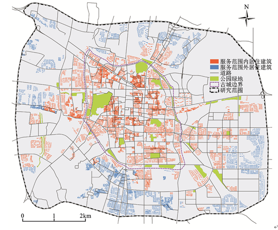
1) 古城内公园绿地服务覆盖度较好。相比于古城外围区域,绍兴古城内公园绿地总体特征为数量多、规模大:古城内不仅拥有绍兴主城区内已建成的3个综合性公园(府山公园、蕺山公园、塔山公园),而且还集中了像东大池公园、儿童公园、沈园等其他不同类型的公园。保存较好的古城空间肌理、较小的空间尺度以及较高的道路网络密度为公园绿地可达性创造了良好条件。评价结果显示,绍兴古城内公园绿地具有较好的服务覆盖度,实现了公园绿地服务范围对古城区域的全覆盖(图2)。
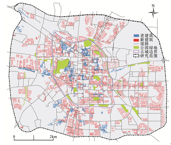
图 2 评价区域居住建筑空间分布
Fig. 2 Spatial distribution of residential architectures in the study area
2) 公园绿地服务覆盖度由内向外呈逐渐减弱的态势。绍兴古城外围土地使用功能主要为居住用地、公共管理与公共服务设施用地、商业服务设施用地、工业用地等,包含了当前正在建设中的迪荡新城与工业园区。其主要开发建设模式为政府主导下的增量规划建设,这与古城内注重空间保护的存量更新发展模式截然不同。相比之下古城外围具有建设开发强度高、速度快,用地混合度低,道路网间距大等空间特点。开发主体在短期经济利益驱动下,古城外围在建设过程中存在着公园绿地建设开发滞后于城市空间扩张的现象,部分外围已建成的住区在可达性范围内并没有一定规模、品质的公园绿地供市民开展游憩休闲活动。分析结果表明,在古城外围出现了公园绿地服务覆盖的真空区。随着城市空间向外扩张,公园绿地服务覆盖度呈现出自古城内部向外逐渐降低直至最外围空间为零覆盖的特征(图3)。
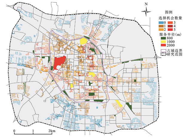
分析结果显示,市民所具有的对公园绿地的选择机会为0~5个(表2)。从人口与机会数量的关系上看,随着选择机会数量的增多,对应的人口数量呈现递减的态势,二者关系呈现出金字塔形状:选择机会为0个的人数最多,占评价区总人口的36.15%,意味着区内36.5%的市民在一定可达性范围内没有可供选择的公园绿地,这些人群处于公共资源使用者所构成的人群金字塔的最底层;选择机会为5个的人数最少,仅占人口总量的0.04%,构成了金字塔的塔尖。
表 2 公园绿地选择机会数量与对应的人口规模
Table 2 The quantity of selection opportunities and the corresponding population size
| 选择机会数量(个) | 市民数量(人) | 占总人口百分比(%) |
|---|---|---|
| 0 | 153513 | 36.15 |
| 1 | 102136 | 24.05 |
| 2 | 96096 | 22.63 |
| 3 | 57276 | 13.49 |
| 4 | 15494 | 3.65 |
| 5 | 186 | 0.04 |
从选择机会的空间分布来看(图4),评价区域内公园绿地选择机会空间分布不公平现象较为严重。在公园绿地服务范围全覆盖的古城内,市民在一定可达性范围内可供选择的公园绿地数量大多为1~4个,少部分甚至达到了5个。而古城外围在一定可达性范围内可供市民选择的公园绿地大多为1~3个,部分达到了4个,在评价区域最外围沿二环路的部分区域(评价区域边缘)选择机会为0个。综上,评价区域内的公园绿地选择机会不公平现象严重,主要表现为古城内市民在以公园绿地为目的的出行时,在一定可达性水平内拥有较多的选择,而古城外围市民在一定可达性水平内选择余地较少甚至没有选择。
图 4 公园绿地选择机会空间分布
Fig. 4 Spatial distribution of selection opportunity for using parks
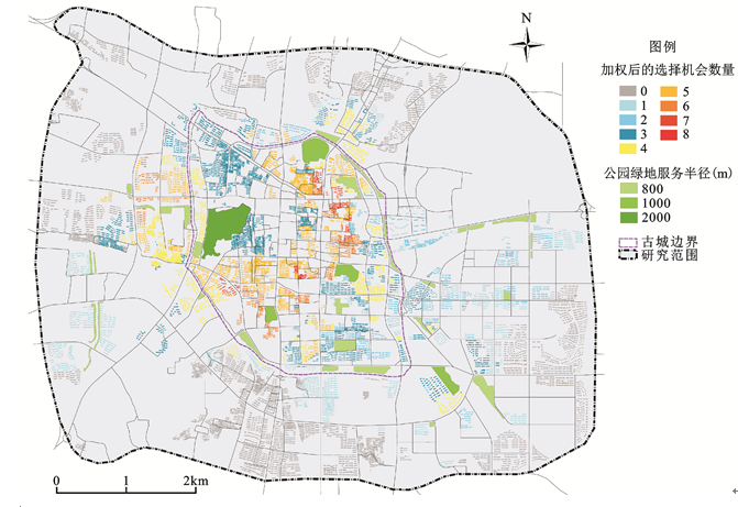
加权汇总后的机会数量可视为市民能享受到的公园服务等级。加权后的机会数量与对应人口规模见表3。分析结果显示, 评价区域内公园绿地选择机会空间分布不公平现象同样较为严重(图5)。与未加权前相比,市民所具有的对公园绿地的选择机会数量最高增加到8个。从人口与机会数量的关系上看:加权后选择机会为0个的人数没有变化;加权后选择机会为7、8的人数最少,两者仅占人口总量的1.2%。
从选择机会的空间分布来看(图5),在公园绿地服务范围全覆盖的古城内,经加权汇总,市民在一定可达性范围内对公园绿地的选择机会大多为1~6,少部分为7~8。而古城外围市民的选择机会大多为1~4,少部分为5~6,在评价区域最外围沿二环路的部分区域(评价区域边缘)选择机会也同样为0个。对照表2和表3,加权后,机会数量的总数增加,对应的人口构成的级差变小,可以更好地表达市民所享有的公园绿地服务功能的空间差异。
图 5 考虑公园绿地吸引力后市民选择机会空间分布
Fig. 5 Spatial distribution of selection opportunities citizens possessed in consideration of the variation of parks attraction
1) 提升现有公园绿地空间品质。提升现有公园绿地的环境品质,特别是要整治提升现状规模过小、不能为市民游憩活动提供支撑的绿地。在用地相对充裕、有建设条件的地段,宜拓展现有公园绿地的面积,增加公共卫生间、健身设施和休闲设施等配套设施,提高其设施供给水平,力求营造出与自然接近的休闲游憩氛围的同时,增强其服务能力。
2) 古城内部宜增设社区公园绿地。当前绍兴古城内几乎集中了已建成的全部综合性公园与专类公园,而居民日常使用频率较高的社区公园数量较少。在当前古城内可用于建设的土地面积较为有限的情景下,公园绿地的建设宜以增加小型社区公园绿地为重点。在古城内旧民居改造过程中,也应预留部分用地作为小型公园绿地,以形成沿河、沿巷的绿化节点。
3) 保障古城外围公园绿地建设与城市开发同步。针对古城外围社区公园绿地建设滞后于城市开发的现状,在今后城市开发建设过程中,社区公园绿地的建设与住区开发应保持同步。在这一过程中,需要公共部门设立奖励与惩罚机制来引导私人部门对公园绿地进行投资以及规避开发主体在城市开发过程中的不道德行为。
4) 削减选择机会空间分布不公平现象。为了保证研究区域内公园绿地选择机会的公平性,需要削减机会密集区公园绿地的公共属性。可对选择机会密集区的部分公园绿地设立价格机制,并使这部分公园绿地向高品质空间转化,以迎合部分市民对公园绿地的高端诉求。从机会公平的角度审视,机会密集区公园绿地公共属性的减弱可以保证更大空间范围内的选择机会公平性。另外,在新建公园绿地时,应从机会公平的角度审视公园绿地的选址,避免将新建公园绿地布局在现状公园绿地选择机会密集区。
表 3 加权后的机会数量与对应的人口规模
Table 3 The weighted quantities of selection opportunities and the corresponding population size
| 加权后的机会数量 | 市民数量(人) | 占人口百分比(%) |
|---|---|---|
| 0 | 153513 | 36.15 |
| 1 | 58379 | 13.75 |
| 2 | 31475 | 7.41 |
| 3 | 72285 | 17.02 |
| 4 | 35479 | 8.35 |
| 5 | 49785 | 11.72 |
| 6 | 18701 | 4.40 |
| 7 | 4610 | 1.09 |
| 8 | 474 | 0.11 |
本文在传统公园绿地可达性评价研究的基础上,结合居住建筑尺度上的人口分布数据,引入了机会公平视角,以绍兴为例,对绍兴古城及周边地区的公园绿地的可达性做了较精细的评价。实证研究表明:① 绍兴古城内公园绿地具有较好的服务覆盖度,实现了公园绿地服务范围对古城区域的全覆盖。但古城外围出现了公园绿地服务覆盖的真空区。随着城市空间向外扩张,公园绿地服务覆盖度呈现出自古城内部向外逐渐降低直至最外围空间为零覆盖的特征。② 研究区域内公园绿地选择机会不公平现象严重,主要表现为古城内外的机会分布不均衡:古城内市民在以公园绿地为目的地出行时,在一定可达性水平内拥有较多的选择,而古城外围市民的选择余地较少甚至没有选择。③ 根据公园绿地的吸引力指数对机会数量进行加权,加权处理后机会数量的总数增加,对应的人口构成的级差变小,可以更好地衡量市民在享用公园绿地上的机会公平性差异。
根据分析结论进一步提出了优化公园绿地布局的策略:通过增加健身、休闲设施等配套设施、拓展公园绿地面积,提升公园绿地的环境品质和服务能力;古城内的公园绿地建设以增加小型社区公园绿地为重点;政府设立奖励与惩罚机制确保社区公园绿地的建设与住区开发同步;设立价格机制,促成机会密集区的公园绿地向高品质空间转化;力避将新建公园绿地布局在现状公园绿地选择机会密集区。
需要指出的是,论文还存在以下不足:吸引力指数的确定还带有较大的主观性;市民在使用公园绿地时存在着竞争性,也即公园绿地的容量是有限的,未对不同社会属性人口的多样性诉求进行差异化分析。以上几方面有待后续研究。
The authors have declared that no competing interests exist.
| [1] |
The role of urban parks for the sustainable city [J].https://doi.org/10.1016/j.landurbplan.2003.08.003 Magsci [本文引用: 1] 摘要
<h2 class="secHeading" id="section_abstract">Abstract</h2><p id="">International efforts to preserve the natural environment are mainly concerned with large, bio-diverse and relatively untouched ecosystems or with individual animal or vegetal species, either endangered or threatened with extinction. Much less attention is being paid to that type of nature close to where people live and work, to small-scale green areas in cities and to their benefits to people. Increasing empirical evidence, however, indicates that the presence of natural areas contributes to the quality of life in many ways. Besides many environmental and ecological services, urban nature provides important social and psychological benefits to human societies, which enrich human life with meanings and emotions. The main concern of this paper is to address the importance of urban nature for citizens’ well being and for the sustainability of the city they inhabit. Some results of a survey conducted among visitors of an urban park in Amsterdam (The Netherlands) are presented and discussed. The issues investigated concern people’s motives for urban nature, the emotional dimension involved in the experience of nature and its importance for people’s general well being. Results confirm that the experience of nature in urban environment is source of positive feelings and beneficial services, which fulfill important immaterial and non-consumptive human needs. Implications for the sustainability of the city will be analyzed and discussed.</p>
|
| [2] |
The significance of parks to physical activity and public health: A conceptual model [J].https://doi.org/10.1016/j.amepre.2004.10.024 URL PMID: 15694524 摘要
Park-based physical activity is a promising means to satisfy current physical activity requirements. However, there is little research concerning what park environmental and policy characteristics might enhance physical activity levels. This study proposes a conceptual model to guide and suggest hypotheses. This framework describes the relationships between park benefits, park use, and physical activity, and the antecedents/correlates of park use. In this classification scheme, the discussion focuses on park environmental characteristics that could be related to physical activity, including park features, condition, access, aesthetics, safety, and policies. Data for these categories should be collected within specific geographic areas in or around the park, including activity areas, supporting areas, the overall park, and the surrounding neighborhood. Future research should focus on how to operationalize specific measures and methodologies for collecting data, as well as measuring associations between individual physical activity levels and specific park characteristics. Collaboration among many disciplines is needed.
|
| [3] |
Using Participatory GIS to measure physical activity and urban park benefits [J].https://doi.org/10.1016/j.landurbplan.2013.09.006 URL 摘要
Previous urban park research has used self-reported surveys and physical activity logs to examine associations between physical activity and park features, size, and distance to participants' homes. In this study, we used participatory geographic information systems (GIS) methods to explore potential correlates of physical activity and other health benefits in urban parks. Using an internet-based public participation geographic information system (PPGIS) system, study participants identified the spatial locations where they engaged in various types of physical activity and where they received other park benefits-environmental, social, and psychological health benefits. Using an urban park typology, we found that different urban park types provide different opportunities for physical activity with linear parks providing the greatest overall physical benefit while other park types provided important non-physical community benefits. Distance to park was not a significant predictor of physical activity but park size was correlated with physical activity and other park benefits. We discuss the strengths and limitations of using PPGIS methods for understanding the benefits of urban park systems.
|
| [4] |
Nature, race, and parks: Past research and future directions for geographic research [J].https://doi.org/10.1177/0309132509103156 URL 摘要
Geographic research on parks has been wide-ranging but has seldom examined how and why people use parks, leaving these questions to leisure science, which privileges sociodemographic variables over urban socio-spatial explanations (eg, historical, political-economic, and location factors). This article examines recent geographic perspectives on park use, drawing upon environmental justice, cult...
|
| [5] |
McKenzie T L, Sehgal A et al. Contribution of public parks to physical activity [J]. |
| [6] |
Accessibility to green spaces: GIS based indicators for sustainable planning in a dense urban context [J]. |
| [7] |
城市公园可达性研究 ——方法与关键问题 [J].
城市公园是城市居民主要的休闲游憩场所,对促进其身心健康,建设和谐可持续社会具有重要意义。伴随快速城市化,城市居民对城市公园的需求与日俱增,不仅仅关注城市公园的数量,更关心能否方便快捷地进入公园进行游憩活动。这对城市公园的评价和合理规划提出了新要求。基于GIS的可达性研究从公园与市民相互关系角度出发,能够较好地评价城市公园的空间分布,是评价城市公园空间分布合理性和服务公平性的主要手段。多种可达性计算方法的出现为城市公园可达性研究中方法的选择提供了充分的余地,但不同的方法基于不同的理论,对数据要求不同,反映可达性的不同方面,对各种可达性计算方法的理解是选择适宜可达性计算方法进行城市公园可达性研究的前提。将城市公园可达性研究中常用的可达性计算方法分为4类6种,分别评述了其原理和优缺点,为城市公园可达性研究中方法的选择提供参考。同时分析了城市公园可达性研究中的关键问题,探讨了未来城市公园可达性研究的重点。
Accessibility analysis of urban parks: methods and key issues .
城市公园是城市居民主要的休闲游憩场所,对促进其身心健康,建设和谐可持续社会具有重要意义。伴随快速城市化,城市居民对城市公园的需求与日俱增,不仅仅关注城市公园的数量,更关心能否方便快捷地进入公园进行游憩活动。这对城市公园的评价和合理规划提出了新要求。基于GIS的可达性研究从公园与市民相互关系角度出发,能够较好地评价城市公园的空间分布,是评价城市公园空间分布合理性和服务公平性的主要手段。多种可达性计算方法的出现为城市公园可达性研究中方法的选择提供了充分的余地,但不同的方法基于不同的理论,对数据要求不同,反映可达性的不同方面,对各种可达性计算方法的理解是选择适宜可达性计算方法进行城市公园可达性研究的前提。将城市公园可达性研究中常用的可达性计算方法分为4类6种,分别评述了其原理和优缺点,为城市公园可达性研究中方法的选择提供参考。同时分析了城市公园可达性研究中的关键问题,探讨了未来城市公园可达性研究的重点。
|
| [8] |
The physical and non-physical factors that influence perceived access to urban parks [J].https://doi.org/10.1016/j.landurbplan.2014.09.007 URL [本文引用: 1] 摘要
Access to urban parks and green space is purported to contribute to community well-being and inclusive neighbourhoods. While accessibility has been developed as a multidimensional construct in the literature, few studies have empirically investigated the mix of both physical and non-physical factors that influence self-reported access to urban parks. To fill this knowledge gap, we conducted community level surveys in Brisbane, Australia, to empirically test a multivariate model of park accessibility. We collected primary data in two suburbs with contrasting social economic status (SES) but comparable park infrastructure. Multiple regression models containing both physical and non-physical variables were developed and tested. Our findings concur with existing studies indicating lower perceived park accessibility in the lower SES neighbourhood. The most important factors influencing perceived accessibility to urban parks were physical and locational features such as proximity to the park, a pleasant walking experience, and a sufficient number of parks in the neighbourhood. Less important, but statistically significant social variables included cultural groups using the parks, shared activities, safety, and leisure time available. These findings provide empirical support for the multidimensional nature of the accessibility construct. We discuss the implications of our findings for park planning in metropolitan areas.
|
| [9] |
A framework for the study of access to medical care [J].URL PMID: 4436074 [本文引用: 1] 摘要
Health Serv Res. 1974 Fall;9(3):208-20.
|
| [10] |
|
| [11] |
An integrated approach to measuring potential spatial access to health care services [J].https://doi.org/10.1016/0038-0121(92)90004-O URL PMID: 10123094 [本文引用: 1] 摘要
By Abdullah A. Khan; An integrated approach to measuring potential spatial access to health care services
|
| [12] |
Optimizing access to public services [J]. |
| [13] |
Smoyer-Tomic K E, Hodgson M J. Measuring neighbourhood spatial accessibility to urban amenities: does aggregation error matter? [J] |
| [14] |
城市绿地可达性与公平性评价 [J].
城市绿地是城市重要的绿色基础设施,是实现城市可持续发展的重要空间保障,具有重要的生态、社会文化功能。20世纪80年代以来,我国一直以城市人均(公共、公园)绿地面积、绿地率、绿化覆盖率等面积比率指标作为核心指标来指导城市绿地建设,缺乏具体引导城市绿地空间分布的指标,较少关注城市绿地服务功能的公平性问题。借助于GIS技术,构建了城市绿地社会功能评价的简明框架,尝试将表征城市绿地空间分布的可达性和公平性指标引入城市绿地的功能评价中,以体现城市建设“以人为本”、“社会公平”的理念,并以上海和青岛为实证,对新构建的系列指标进行了分析与检验。研究结果表明:(1)可达性和公平性系列指标导入城市绿地的功能评价中是可行的,能够有效的表征和测度城市绿地空间布局的合理性程度;(2)可达性和公平性指标使用时需要界定研究区范围、研究尺度,特别是数据精度,以利于研究区的纵向比较和城市间的横向比较。研究结果将丰富我国城市绿地评价的核心指标体系,亦可为城市规划者和建设者合理规划与布局城市绿地提供重要的依据和参考。
Accessibility and equity assessment on urban green space .
城市绿地是城市重要的绿色基础设施,是实现城市可持续发展的重要空间保障,具有重要的生态、社会文化功能。20世纪80年代以来,我国一直以城市人均(公共、公园)绿地面积、绿地率、绿化覆盖率等面积比率指标作为核心指标来指导城市绿地建设,缺乏具体引导城市绿地空间分布的指标,较少关注城市绿地服务功能的公平性问题。借助于GIS技术,构建了城市绿地社会功能评价的简明框架,尝试将表征城市绿地空间分布的可达性和公平性指标引入城市绿地的功能评价中,以体现城市建设“以人为本”、“社会公平”的理念,并以上海和青岛为实证,对新构建的系列指标进行了分析与检验。研究结果表明:(1)可达性和公平性系列指标导入城市绿地的功能评价中是可行的,能够有效的表征和测度城市绿地空间布局的合理性程度;(2)可达性和公平性指标使用时需要界定研究区范围、研究尺度,特别是数据精度,以利于研究区的纵向比较和城市间的横向比较。研究结果将丰富我国城市绿地评价的核心指标体系,亦可为城市规划者和建设者合理规划与布局城市绿地提供重要的依据和参考。
|
| [15] |
上海公园空间可达性与公平性分析 [J].https://doi.org/10.3969/j.issn.1006-3862.2009.06.013 URL [本文引用: 1] 摘要
公园是城市绿色基础设施的重要 组成部分,是城市居民游憩活动的重要场所,具有重要的生态、娱乐、休憩和社会文化等功能。在遥感和地理信息系统技术的支持下,以上海市为例,运用最小邻近 距离分析方法对研究区公园的空间可达性进行了定量评价,并结合上海市第五次人口普查数据资料,采用需求指数,分析了研究区各街道居民对城市公园的需求情 况,在此基础上,采用定序变量相关分析和因子空间叠置分析两种方法定量测度了研究区公园布局的空间公平性程度。研究结果表明:(1)研究区可达性水平总体 上较高,超过半数的居住区出行不足1000m即可到达一个公园,超过70%的街道可达性水平较好;(2)在街道水平上研究区公园空间布局总体上比较公平、 较为合理,可达性水平与需求指数呈显著相关,很高或高需求的街道70%左右均具有很好或好的可达性。
Spatial accessibility and equity of parks in Shanghai .https://doi.org/10.3969/j.issn.1006-3862.2009.06.013 URL [本文引用: 1] 摘要
公园是城市绿色基础设施的重要 组成部分,是城市居民游憩活动的重要场所,具有重要的生态、娱乐、休憩和社会文化等功能。在遥感和地理信息系统技术的支持下,以上海市为例,运用最小邻近 距离分析方法对研究区公园的空间可达性进行了定量评价,并结合上海市第五次人口普查数据资料,采用需求指数,分析了研究区各街道居民对城市公园的需求情 况,在此基础上,采用定序变量相关分析和因子空间叠置分析两种方法定量测度了研究区公园布局的空间公平性程度。研究结果表明:(1)研究区可达性水平总体 上较高,超过半数的居住区出行不足1000m即可到达一个公园,超过70%的街道可达性水平较好;(2)在街道水平上研究区公园空间布局总体上比较公平、 较为合理,可达性水平与需求指数呈显著相关,很高或高需求的街道70%左右均具有很好或好的可达性。
|
| [16] |
城市公园绿地规划中的可达性指标评价方法 [J].
针对城市公园绿地规划和建设的特点,应用GIS提出一种易操作和可验证的绿地可达性指标定量评价模式。该模式综合考虑了绿地规模、人口分布和交通成本因素,比较客观准确地建立了阻力模型,有可以度量实测的指标结果。经过方法比较和案例验证,这种模式的评价结果更适合作为城市公园绿地规划的可达性指标。
Evaluation method for measurement of accessibility in urban public green space planning .
针对城市公园绿地规划和建设的特点,应用GIS提出一种易操作和可验证的绿地可达性指标定量评价模式。该模式综合考虑了绿地规模、人口分布和交通成本因素,比较客观准确地建立了阻力模型,有可以度量实测的指标结果。经过方法比较和案例验证,这种模式的评价结果更适合作为城市公园绿地规划的可达性指标。
|
| [17] |
Measuring potential access to primary health care services: The influence of alternative spatial representations of population [J]. |
| [18] |
Investigating the implications of using alternative GIS-based techniques to measure accessibility to green space [J].https://doi.org/10.1068/b37130 URL 摘要
A large body of research has examined relationships between accessibility to green space and a variety of health outcomes with many researchers finding benefits in terms of levels of physical activity and relationships with levels of obesity, mental health, and other health conditions. Such studies often use spatial analytical techniques to examine relationships between distance to such spaces and health data collated at an individual survey respondent鈥檚 home address or, more commonly, derived from area-based census measures summarised at a centroid. Generally, such measures are becoming more sophisticated and have moved on from the use of straightforward Euclidean-based measures to those based on network distance. However, few studies tend to use a combination of approaches or seek to establish the implications of incorporating alternative measures of accessibility on potential relationships. Using a database of green spaces (and associated attributes) and a detailed network dataset for the city of Cardiff, Wales, we examine the sensitivity of findings to the ways in which different metrics are calculated. This is illustrated by examining the variations in association between such metrics and a census-based deprivation index widely used in health studies to measure socioeconomic conditions. Our findings demonstrate that not only will the distances to green spaces vary according to the methodologies adopted but that any study that aims to investigate relationships with attributes of the nearest green space should acknowledge that matches may vary widely according to the techniques used. We conclude by warning against the use of inappropriate methodologies in examining access to green space which may directly influence directions (and levels) of association and hence may limit their relevance in wider geographical contexts. Keywords: green space, accessibility, GIS, spatial data, representation, network distances
|
| [19] |
Measuring spatial accessibility in the context of spatial disparity between demand and supply of urban park service [J].https://doi.org/10.1016/j.landurbplan.2013.07.001 URL [本文引用: 1] 摘要
Urban parks are amenities that promote urban residents鈥 quality of life, and therefore, one of the primary issues in urban planning is to ensure accessibility to urban parks for appropriate service provision. In many cities, however, accessibility varies by locality. Some localities may suffer from inaccessibility because few suitable parks are located near densely populated areas. The magnitude of inaccessibility in this context is represented by the spatial disparity between demand for and supply of urban park services. In addition, if limited accessibility is prevalent across the city, the region-wide lack of park services due to overall inaccessibility would be a major concern. This paper aims to develop a spatial disparity measure that indicates the inaccessibility of park services in order to identify where they are deficient in consideration of the underlying demand population and to determine the overall condition of service deficiency. This measure is expected to aid urban planners in understanding the overall inaccessibility and determining where to prioritize the provision of park services.
|
| [20] |
Measuring accessibility: an exploration of issues and alternatives [J]. |
| [21] |
城乡基本公共服务设施均等化研究评述及展望 [J].https://doi.org/10.3969/j.issn.1006-0022.2011.11.001 URL [本文引用: 1] 摘要
基本公共服务设施是基本公共服 务的载体,促进基本公共服务设施的均等化布局是从空间规划与建设角度推动城乡统筹发展的重要途径。通过对既有研究成果的综述可以看到,目前国内学者的研究 较多集中在公共服务设施均等化的内涵和实现路径方面,较少关注公共服务在空间层面的落实,且尚未将基本公共服务与基本公共服务设施进行系统的整合。今后应 进一步拓宽基本公共服务设施均等化研究的广度和深度,从公共服务设施配置布局、配置标准和规范等方面加强研究。
Equal urban rural public service facility development .https://doi.org/10.3969/j.issn.1006-0022.2011.11.001 URL [本文引用: 1] 摘要
基本公共服务设施是基本公共服 务的载体,促进基本公共服务设施的均等化布局是从空间规划与建设角度推动城乡统筹发展的重要途径。通过对既有研究成果的综述可以看到,目前国内学者的研究 较多集中在公共服务设施均等化的内涵和实现路径方面,较少关注公共服务在空间层面的落实,且尚未将基本公共服务与基本公共服务设施进行系统的整合。今后应 进一步拓宽基本公共服务设施均等化研究的广度和深度,从公共服务设施配置布局、配置标准和规范等方面加强研究。
|
| [22] |
促进我国基本公共服务均等化的战略思路和基本对策 [J].URL 摘要
一、 三步走的中长期战略思路。第一步(2007~2010年):在确定全国性基本公共服务的范围的基础上,建立基本公共服务国家标准及数据采集和监测体系;建 立基本公共服务国家标准和基本公共服务支出随着经济总量增加和财政能力提高的自然增长机制;继续加大对基本公共服务的投入力度,
Strategic idea and basic countermeasures to promote the equalization of basic public services in China .URL 摘要
一、 三步走的中长期战略思路。第一步(2007~2010年):在确定全国性基本公共服务的范围的基础上,建立基本公共服务国家标准及数据采集和监测体系;建 立基本公共服务国家标准和基本公共服务支出随着经济总量增加和财政能力提高的自然增长机制;继续加大对基本公共服务的投入力度,
|
| [23] |
基本公共服务均等化的公共财政政策研究 [J].
一、基本公共服务最低公平——均等化的基本模式 我们应怎样实现均等化?笔者总结各国做法,大体有人均财力的均等化、公共服务标准化和基本公共服务最低公平等三种模式。以下,笔者结合对各模式利弊分析来考量我国的均等化路径。
Public financial policy research on the equalization of basic public services .
一、基本公共服务最低公平——均等化的基本模式 我们应怎样实现均等化?笔者总结各国做法,大体有人均财力的均等化、公共服务标准化和基本公共服务最低公平等三种模式。以下,笔者结合对各模式利弊分析来考量我国的均等化路径。
|
| [24] |
绍兴市人民政府. 绍兴中心城市住房和基础设施建设“十二五”规划 [N/OL]. . |
| [25] |
绍兴搜房网数据监控中心. 绍兴市2012年终楼市白皮书(成交篇) [N/OL]. [Shaoxing soufun data monitoring center. 2012 Shaoxing City’s annual white paper on the housing market. .] |
| [26] |
绍兴市人民政府. 绍兴市人口区划数据 [N/OL]. |
| [27] |
绍兴市越城区人民政府. 绍兴市越城区2013年统计年鉴 [N/OL]. .2013 Statistical yearbook of Yuecheng District, Shaoxing City. .] |
| [28] |
易智瑞(中国)信息技术有限公司. ArcGIS 10.2产品白皮书 [N/OL].. |

/
| 〈 |
|
〉 |
