舒培仙 , 李保生, 牛东风
Shu Peixian, Li Baosheng, Niu Dongfeng
中图分类号: P532
文献标识码: A
文章编号: 1000-0690(2016)03-0448-10
通讯作者:
收稿日期: 2014-12-5
修回日期: 2015-03-16
网络出版日期: 2016-03-20
版权声明: 2016 《地理科学》编辑部 本文是开放获取期刊文献,在以下情况下可以自由使用:学术研究、学术交流、科研教学等,但不允许用于商业目的.
基金资助:
作者简介:
舒培仙(1990-),男,安徽宣城人,博士研究生,主要研究方向为地表过程与第四纪环境演变。E-mail: shupeixian@163.com
展开
摘要
分析滴哨沟湾剖面全新统DGS1段的粒度数据,认为流动沙丘砂、泥炭、砂质古土壤、古固定-半固定沙丘砂到湖沼相和次生黄土的颗粒总体上变细,分选变差。结合腹足类动物化石和湖沼相地层中石英砂粒表面电镜扫描,认为DGS1粒度结果实际上是全新世以来多次冬夏季风的交互演替过程的气候-地质记录。据此,将DGS1粒度信号记录的全新世气候分为4个阶段——全新世早期好转期、全新世鼎盛期、大暖期向寒冷期转变波动期和降温不稳定的沙漠化频繁变化时期。
关键词:
Abstract
The DGS1 segment in the Dishaogouwan section from the Salawusu River valley is a typical stratum to study the climate variations in the Holocene. Based on the dating ages and analysis of the grain-size features within the DGS1,we find that the particle gradually becomes finer but the sorting rate becomes poorer from mobile dune sands, peat, paleosols, semi-fixed sand dunes to the lacustrine facies and secondary loess; the grain-size parameter values of Mz(ϕ), σ1(ϕ), SK1 in the dune sands are lower than those in the lacustrine facies or secondary loess, and the KG value shows opposite trends; the Mz ranges from 2.26 to 3.36 (average 2.55) in the dune sands, 2.33 to 6.33 (average 4.28) in the lacustrine facies and 4.25 to 5.27 (average 4.58) in the secondary loess; the σ1(ϕ) ranges from 0.51 to 2.51 (average 0.97) in the dune sands, 0.81 to 3.25 (average 2.13) in the lacustrine facies and 1.10 to 2.46 (average 1.46) in the secondary loess; the SK1 ranges from 0.01 to 0.45 (average 0.29) in the dune sands, 0.09 to 0.53 (average 0.32) in the lacustrine facies and 0.22 to 0.38 (average 0.36) in the secondary loess; the KG ranges from 0.92 to 1.70 (average 1.42) in the dune sands, 0.65 to 1.80 (average 1.13) in the lacustrine facies and 1.22 to 1.51 (average 1.44) in the secondary loess. They display distinct variations that correspond to the sedimentary changes. The surface microstructure of the quartz grains in the lacustrine facies under the electron microscope scanning shows typical aeolian characteristics with good roundness, without precipitated silica, but with pits on the surface. Together with the freshwater gastropod fossils discovered in the stratigrapgical layers, we suggest that the grain-size cycles in the DGS1 segment actually reflect the climate variations in the alternation of East Asian winter and summer monsoons in the Holocene, and the climate of the Holocene can be divided into four stages: the warming period of the Early Holocene; Holocene heyday; the fluctuation period from the Megathermal to cold; and the cooling period of instability and desertification. The climate changes in the DGS1 during the Holocene correspond well to those found in the North Atlantic and some places in China, which probably results from the global climate changes in the Holocene.
Keywords:
全新世是与人类关系最密切的一个时期,新仙女木事件结束后,在全球气温回暖的大背景下,北大西洋共发生了9次冷事件[1,2],全新世气候的不稳定性在全球各地的地质记录中相继得到证实[3],而在东亚季风环境影响下的中国中纬地区,类似的气候波动事件在石笋[4]、湖泊[5]、泥炭[6]等沉积物中也有记录。然而,全新世期间东亚季风通过全球变化如何对中国沙漠施加影响的,这些气候事件与冰芯和海洋在时间上是否可以对比等相关问题还有待深入研究。显然,这一问题的探讨对于全新世全球变化与中国沙漠区域的东亚季风环境演变的理解具有重要意义。
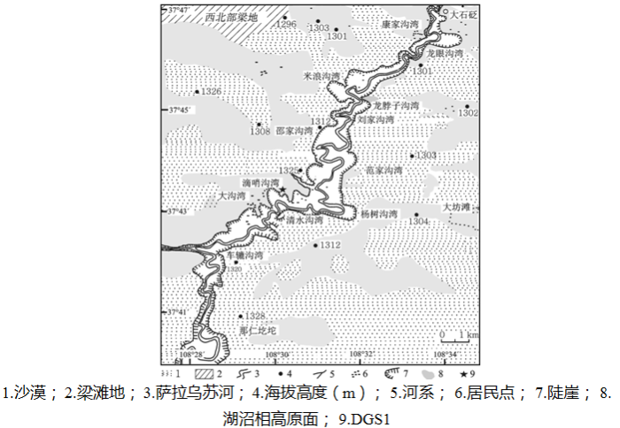
萨拉乌苏河流域位于内蒙古鄂尔多斯高原毛乌素沙漠东南部边缘(图1)。该流域是中国北方上更新统河湖沼相标准地层萨拉乌苏组的命名地[7]。流域上更新统–全新统多层序的风成沙丘砂、河湖沼相和古土壤沉积,忠实的记录了沙漠地区长期的风沙活动。最近10 a来萨拉乌苏流域环境变化的研究工作有了一些新进展[8~12],其中Niu et al.和Lü et al.对米浪沟湾MGS1层段的研究表明,全新世以来毛乌素沙漠曾经历了类似于D/O振荡式的东亚冬夏季风的波动[11,13],其中的风成沙丘砂活动事件在时间和气候性质上与北大西洋11 000 a B.P.以来的寒冷波动基本一致。然而这中变化的客观存在仍然需要更多的地质材料进行佐证。
本文选取了邻近米浪沟湾剖面的滴哨沟湾剖面全新统——DGS1层段(以下称DGS1),以粒度分析结果为依据,结合年代测试结果,试图讨论萨拉乌苏流域全新世气候波动与季风环境变化之间的关系,以此加深对该区域环境演变过程的理解。
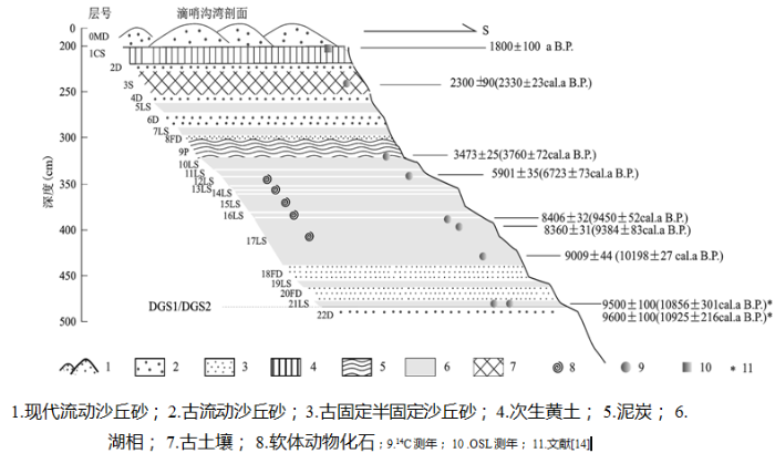
滴哨沟湾剖面位于萨拉乌苏河流域滴哨沟湾村的河流左岸,地理坐标为37°43′26.3″N,108°31′2.3″E,剖面顶部海拔高度1 309 m(图1)。该剖面地层出露厚度为62.70 m(图2),时代包括全新统、上更新统和中更新统上部[15]。DGS1的堆积深度为0~4.84 m,包括12层湖沼相(LS)、3层古流动沙丘砂(D)、1层现代流动沙丘砂(0MD)、3层古固定-半固定沙丘砂(FD)、1层砂质古土壤(S)、1层泥炭(P)和1层次生砂质黄土(CS)。
DGS1总共有7个样品的年代测试结果,其中6个常规14C年代(表1)[16]和1个OSL年代(见图2)。14C年代由中国科学院寒区旱区环境与工程研究所14C实验室测定。OSL年代由中国地质矿产部水文地质工程地质研究所光释光实验室完成。对14C年代采用Calib7.0程序中Intcal 13数据集[16]进行校正(表1)。由于这6个常规14C年代测试结果在第4个年代出现倒置,其余均符合地层层序律原则,将此点删除,并以剩下测定年代为控制点运用沉积速率线性内插方法建立该剖面的时间标尺(图2)。同时滴哨沟湾剖面DGS1底部已有大量的绝对年代值[15~17]。如图2所示,我们使用苏志珠等[16]该层段底部(21LS)14C年代测定结果作为全新世开始。剖面1CS顶部OSL年代为1 800±100 a B.P.,最新的光释光年代结果[18]与14C年代结果也吻合较好。
表1 滴哨沟湾DGS1层段14C年龄测定结果
Table 1 14C dating ages and calendar ages of some horizons in the DGS1
| 地层 | 深度(cm) | 年代 (a B. P.) | 测试材料 | 14C校正年代 (a B. P.) |
|---|---|---|---|---|
| 3S | 238 | 2300±90 | 有机质 | 2330±23 |
| 9P | 320 | 3473±25 | 有机质 | 3760±72 |
| 12LS | 342 | 5901±35 | 有机质 | 6723±73 |
| 16LS | 388 | 8406±32 | 有机质 | 9450±52 |
| 17LS | 398 | 8360±31 | 有机质 | 9384±83 |
| 17LS | 432 | 9009±44 | 有机质 | 10198±27 |
按照1~2 cm间隔对采集的234个样品进行了粒度分析。分析仪器为Mastercizer 2000 M型激光粒度分析仪,分析范围0.02~2 000 µm,误差<2%。粒度单位采用ϕ值表示,转换公式为克伦宾[19]制定的f=-log2d(d为粒径mm)。平均粒径(Mz)、标准偏差(σ1)、偏度(SK1)和峰度(KG)等粒度参数的计算采用Folk and Ward [16]所制定公式。
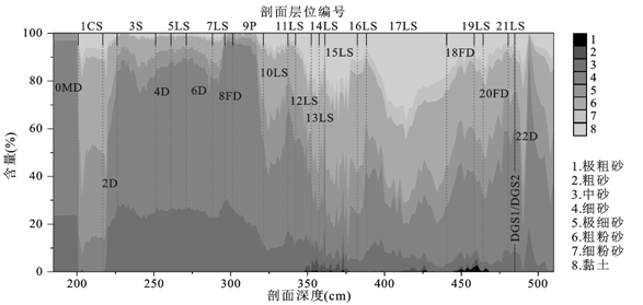
根据粒度分析结果,绘制颗粒各粒级累积百分含量垂向变化图(图3),可以直观地显示出不同粒级含量在不同地层层位和深度的分配关系与变化,亦可以显示出各层岩性特征。
DGS1层段的底部21LS及上出现的湖沼相层,是该层段厚度最大的沉积相。由图3可知,整个湖沼相层平均含量最高组分是细砂,平均值为33.07%,最高含量超过60%;其次是粗粉砂,平均含量23.54%;其余组分由高到低依次为极细砂、黏土、中砂和细粉砂,平均值依次为14.26%,12.89%,11.01%和4.42%。不含极粗砂。
图3 DGS1层段粒度累计百分比含量垂向变化
Fig.3 The changes of grain-size cumulative percentage in the DGS1
21LS上覆20FD及剖面中18FD及8FD,从沉积相来看属于古固定–半固定沙丘砂,其细砂、粗粉砂、极细砂、中砂平均含量依次降低但均超过10%,分别为41.56%,21.52%,13.97%,10.01%;黏土和细粉砂平均含量分别为8.32%和4.11%。
泥炭层细砂含量最高,平均值为68.86%;其次是中砂,范围为12.93%~26.46%,平均值为20.93%;极细砂、粗粉砂平均含量为4.64%和4.38%;其它含量均低于1%。
流动沙丘砂包括0MD、6D、4D和2D这4个层位,从图3中可以看出细砂含量占优势,其平均含量达到58.92%,最高含量为73.91%;其次是中砂含量,平均值为24.45%;粗粉砂、极细砂的平均含量均不足10%;几乎不含黏土和细粉砂(不足1%)。这说明了流动沙丘砂主要以细砂和中砂为主,相较于前述的古固定-半固定沙丘砂,表现出粗颗粒组分(中砂)含量的增加,细颗粒组分(黏土和细粉砂)含量的减少。
剖面2.5~2.25 m深度范围是砂质古土壤层(3S),粒级组分由高到低依次是细砂、中砂、粗粉砂和极细砂,分别为56.67%,25.34%,8.27%和8.07%。黏土和细粉砂含量相对增加,平均值近1%。可以看出,该层古土壤的发育程度较低。
现代流动沙丘砂之下的次生黄土(1CS)的粗粉砂含量最高,平均含量为39.69%,最高超过50%;其次为极细砂,平均含量为35.29%;细砂、黏土、细粉砂的含量依次降低,平均值依次为13.02%,7.21%,4.46%;中砂、粗砂和极粗砂平均含量均不足1%。
表2是各沉积相的粒度参数平均值及范围。平均粒径以流动沙丘砂、泥炭和砂质古土壤较粗,古固定-半固定沙丘砂次之,湖沼相和次生黄土最细;由泥炭到流动沙丘砂和砂质古土壤再到次生黄土和湖沼相,分选性由较好变差;偏度值(SK1)均为正偏且在泥炭和流动沙丘砂中最低,由古固定-半固定沙丘砂、湖沼相、砂质古土壤和次生黄土中逐渐升高;峰度值(KG)在流动砂丘砂、次生黄土和砂质古土壤均值较湖沼相、古固定–半固定沙丘砂和泥炭大,说明沉积物堆积后期混入了其他的颗粒。
表2 DGS1层段各沉积相粒度参数特征分布
Table 2 Grain size characteristic parameters in the DGS1 segment of each sedimentary facies
| 沉积相(样品数) | 特征参数 | Mz(ϕ) | σ1(ϕ) | SK1 | KG |
|---|---|---|---|---|---|
| 流动沙丘砂(37) | 平均值 | 2.55 | 0.97 | 0.29 | 1.43 |
| 范围 | 2.21~3.36 | 0.51~1.68 | 0.01~0.45 | 0.94~1.70 | |
| 固定半固定沙丘砂(22) | 平均值 | 3.89 | 1.76 | 0.32 | 1.03 |
| 范围 | 2.27~5.12 | 0.53~2.51 | 0.02~0.51 | 0. 92~1.24 | |
| 古土壤(25) | 平均值 | 2.58 | 1.00 | 0.34 | 1.42 |
| 范围 | 2.4~2.87 | 0.81~1.25 | 0.23~0.43 | 1.28~1.61 | |
| 次生黄土(19) | 平均值 | 4.58 | 1.46 | 0.36 | 1.44 |
| 范围 | 4.25~5.27 | 1.15~2.10 | 0.22~0.38 | 1.22~1.51 | |
| 湖沼相(111) | 平均值 | 4.28 | 2.13 | 0.32 | 1.13 |
| 范围 | 2.33~6.38 | 0.81~3.25 | 0.09~0.53 | 0.65~1.80 | |
| 泥炭(20) | 平均值 | 2.54 | 0.71 | 0.14 | 1.07 |
| 范围 | 2.33~3.47 | 0.53~1.69 | 0.03~0.51 | 0.94~1.74 | |
| 全剖面(234) | 平均值 | 3.67 | 1.62 | 0.31 | 1.22 |
| 范围 | 2.21~6.38 | 0.52~3.25 | 0.01~0.53 | 0.65~1.80 |
从垂直方向上看,湖沼相、次生黄土与沙丘砂等的Mz(ϕ)、σ1(ϕ)、SK1、KG构成一峰谷交替的曲线,由沙丘砂至上覆的湖沼相,Mz(ϕ)、σ1(ϕ)、SK1值相应增大,KG相应减小(图4)。DGSI层段粒度特征参数剖面垂向上变化呈现出与沉积旋回相对应的粒度旋回。
图4 DGS1粒度特征参数变化及其所反映的全新世气候波动
Fig.4 The changes of grain-size parameters Mz, σ1, SK1 and KG in the DGS1
萨拉乌苏河流域地处毛乌素沙漠南缘,是东亚季风变化的敏感区,现代该地区冬春季节盛行偏北和西北风向的冬季风,风沙流的蚀积活动加剧;在暖湿的夏秋季节,来自东南的东亚夏季风盛行,降雨和流水作用增强,地表过程以沙丘固定成壤和河湖沉积为主要营力。当然现代毛乌素沙漠南缘,沉积相的变化还会受植被覆盖和区域水热组合状况的影响。但是,近年来一些研究者采用不同气候代用指标探讨了该地区沉积序列及其形成的古气候因素,认为千年尺度的风成砂与古土壤/湖沼相变主要是东亚冬夏古季风冷暖波动的结果[9~13,20~24]。
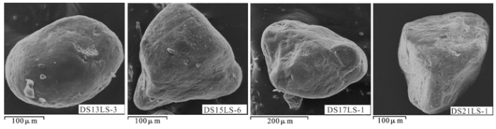
全新世早期,太阳辐射量增加,东亚夏季风增强[25,26],降水增多,地势低洼之处开始汇水成湖,剖面中21LS湖沼相层的出现正是这一过程的体现,但其厚度不大且与固定半固定沙丘砂相互交替,说明此时的湖泊面积较小,当冬季风增强之时,湖泊面积缩小并发育固定半固定沙丘砂。在东亚夏季风强盛时期,特别是全新世大暖期,毛乌素沙漠水热条件好,此时中国东部沙区地表景观上表现为高地普遍发育砂质古土壤,地势低洼之处形成湖泊[27,28],鹿化煜等[29]最新研究表明,大暖期时期毛乌素沙漠几乎全部固定。那么DGS1中所见厚度1.5 m的湖沼相沉积就不足为奇。但是干旱–半干旱地区的表层物质堆积松散,在强风天气条件下,地表粉尘物质容易被风吹扬进入大气环流,在近源或远源地区沉积下来,位于粉尘源区的湖泊作为粉尘“收集器”,将会接纳区域性的较粗的颗粒物质。因此,在干旱-半干旱地区,风成输入组分成为封闭湖泊沉积物的主要来源之一[30]。研究区大风天气频繁,湖泊沉积物的粒度组成中必然有一部分来自风成输入组分。选取DGS1湖沼相沉积层(13LS、15LS、17LS和21LS)中石英颗粒表面进行电镜扫描,发现其磨圆度较好,颗粒表面无硅质沉淀并显现出麻坑(图5),显示出其典型风成特征。这就说明了DGS1中粗颗粒物质的风成成因。当然湖泊流水作用,会带入大量的细颗粒物质,使平均粒径有不同程度的细化,故湖沼相的Mz(ϕ)和σ1(ϕ)值均较大,显示了颗粒变细和分选变差。
图5 DGS1湖沼相沉积中粗颗粒石英砂粒电镜扫描
Fig.5 The surface microstructure of quartz grains from the lacustrine facies in the DGS1
剖面深度3.1 m之上地层不同类型沙丘砂的出现是砂源供给、风力大小和植被覆盖的综合结果[31]。研究地点所处的毛乌素沙漠至少在中更新世就以形成[32,33],而萨拉乌苏流域的地层中保存着非常发育的末次冰期的沙丘砂[34],因而研究地点的沙丘砂补给充足。一般来说,该地区沙丘可以通过两种主要方式形成。一种情况是,干旱的气候导致地表植被覆盖度降低,先前固定或半固定的沙丘活化,沙丘表层砂在风力作用下开始搬运移动,导致沙丘移动或者新沙丘形成。另一种情况是,河流或湖泊等水动力搬运携带外来砂粒,当气候变干,湖泊/河流面积缩小,砂质沉积物在湖滨与河边等地貌部位近源堆积,形成沙丘。早全新世的古固定–半固定沙丘砂的出现应该就是第二种情况下的砂质沉积物。而在全新世大暖期后期,伴随着冬季风增强和夏季风的减弱,该地降水逐渐减少,滴哨沟湾古湖逐渐萎缩,研究地点成为湖滨沼泽地带,强劲的风力所携带的粗砂物质在跃移过程中被沼泽水草阻挡捕获,并受潜育环境影响,剖面厚层湖沼相结束之后出现的泥炭层(9P)可能是这种过渡环境的产物,从而在粒度特征上表现出较粗的平均粒径。在冬季风仍占优势,夏季风也可以影响的形势下,湖泊干涸,风力作用之下砂质物质开始堆积,不多的降水量维持着沙丘表层植被,形成固定–半固定沙丘,这种类型的沙丘粒度组成中粉砂和黏土含量较高,平均粒级偏粗。而当冬季风对该地区起绝对作用,这种环境持续发展,地表植被盖度将大大降低,导致砂质物质大量富集于地表,形成充足砂源,在强劲风力作用下,搬运携带粗粒的碎屑形成地表风沙流,并强迫更多细粒形成尘暴流失,同时抑制黏粒的滋生,使得颗粒粗化,遇到阻碍堆积形成流动沙丘,这一过程就是前述沙丘形成的第一种模式。DGS1中流动沙丘砂粒度平均粒径变粗,Mz(ϕ)值在曲线上表现为低谷与这种环境有密切的关系。当西伯利亚–蒙古高压进一步减弱到冬季风力小于起沙风力(5 m/s)的时期,降尘的发生频率有可能大为增加,次生黄土1CS就是这种气候的直接后果。
据此我们可以认为,DGS1各沉积相的粒度特征旋回实际上是全新世以来多次冬夏季风的交互演替过程的气候-地质记录。
第四纪以来万年至千年尺度的东亚冬夏季风是两个对立统一的主体气候系统,二者存在显著的互为消长的关系[8],其最为直观的后果即是气候地层学记录。滴哨沟湾剖面的沉积序列应该也真实的记录了这一气候变化。
粒度在黄土等风成沉积物研究中被广泛用作东亚冬季风的指标[35]。近年来的许多研究也表明,湖泊沼泽沉积物粒度组成受风场动力影响较大,能够很好的记录区域强沙尘/粉尘事件[30,36]。对风成砂和湖沼相沉积物,粒度均可以作为有效的东亚季风气候代用指标[37]。
这一认识出发,DGS1全新世气候可以分为以下4个阶段:
第1阶段,全新世早期气候好转,21LS-18FD(11 020~10 290 a B.P.),平均粒径Mz(ϕ)逐渐变细,粒度组分中含沙量逐渐降低,黏土含量增高。气候比末次冰期明显好转,冬季风减弱,夏季风增强,沙漠主要以古固定–半固定沙丘为主,温度升高,降水增加,局部地区形成了暂时性湖泊和沼泽,湖沼相发育。但暖湿程度不如后面的鼎盛期。同时该层段常见有较多淡水螺壳,主要为平卷螺和塔螺贝壳[16],另外在地层中也发育冻融卷曲或融冻褶皱现象[16],表明此阶段温度仍然较低,气候相对干凉;该阶段沉积物碳酸盐含量极低,无机碳酸盐碳氧同位素组成相对偏轻[38],表明此阶段主要以河流淡水为主,气候逐渐升高,但降雨量不明显。此阶段据祁连山敦德冰芯记录,冰后期升温开始于10.75 ka B.P.以前,气候发生多次震荡[39]。其中,18FD(10 290~10 580 a B.P.)/20FD(10 670~10 930 a B.P.)所代表的冷事件可与Bond等[2]发现的北大西洋冷事件中的10.3 ka B.P.对比。
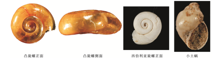
第2阶段,全新世鼎盛期,17LS-12LS(10 290~6 590 a B.P.),平均粒径达到最高点,粒度组分里的黏土含量也达到最高值。在地层上灰白色湖沼相堆积并发育大量淡水腹足类化石为主要特色。软件动物一般迁徒能力很弱,生态环境的阻隔使其适应能力较差,对生活环境的变化较为敏感,如水温、盐度、酦碱度、底质等的要求比较严格,其适应能力有一定范围。经鉴定该层段软体动物主要为凸旋螺(图6)。目前其最南分布于中国广东、云南,国外分布于东南亚一带,最北分布于陕西。这一物种的出现反映了较温暖、湿润的生物气候环境。说明DGS1层段湖沼相沉积的形成时具有比较温暖、湿润的气候环境。同时该层段淡水腹足类化石属种,有许多幼体标本,它们常以绿色水生植物、藻类为食,其在春季产卵孵化后经历过迅速繁殖,但绝大多数可能在春夏之交时受到流水堆积或者更可能是受到季节性的沙尘暴气候的影响而夭折。据此我们认为该时期东亚夏季风强盛,但是区域性的风沙活动依然存在。而对DGS1有机质、碳酸盐和碳酸盐碳氧同位素等进行研究表明[38],该层段有机质、碳酸盐含量快速上升,碳酸盐碳氧同位素组成也明显偏重,表明该段时期滴哨沟湾古湖泊扩张到最大,温度和降雨量同时增加,但是高温导致了蒸发作用的加强,蒸发降雨比值增大,有效湿度不高,植被状况中等,这就证明该时期风沙活动存在的可能性。此鼎盛期在中国多处地点均有记录,如方修琦等[39]根据中国全新世气温集成序列资料认为全新世鼎盛期出现在8~6.4 ka B.P.。
图6 DGS1湖沼相沉积中的淡水类腹足类动物化石
Fig.6 The fossils of the freshwater gastropods from the lacustrine facies in the DGS1
第3阶段,大暖期向寒冷期转变的波动期,11LS-10LS(6 590~3 760 a B.P.)。整个层段平均含砂量比大暖期期间降低,颗粒变粗。有资料显示全新世高温期的晚期气候更不稳定,表现为快速降温变干过程[40]。该层段腹足类化石中西伯利亚旋螺Gyraulus sibiricus (Dunker)、小土蜗Galba pervia (Martens)组合的出现,亦反映了较寒冷、干旱的生物气候环境。这是因为这些种类一般具有耐寒冷的能力,能适应大陆性气候环境,从目前巳知种的地理分布看,主要生活在华北区、蒙新区、青藏区(即古北界区域内),它们系典型的古北界种类。同时该阶段有机质含量较高,碳酸盐含量则快速下降,碳酸盐碳氧同位素组成进一步偏重,表明了温度和降雨量均有所下降。
第4阶段,降温不稳定的沙漠化频繁变化时期,9P-0MD(3 760~0 a B.P.),此阶段粒度颗粒最粗,分选最好。以沙丘砂堆积为特点的干冷多风气候期为主体,且具有不稳定性,期间发育的2D、4D、6D是气候急剧变冷的结果。这与方修琦等[39]认为晚全新世4 ka B.P.以来气候为相对较冷的结果相一致。另外,其中0MD(0~1 800 a B.P.)可与北大西洋冷事件0.4~1.4 ka B.P.对比,6D(2 820~3 140 a B.P.)可与北大西洋冷事件2.8 ka B.P.对比,9P(3 380~3 760 a B.P.)可与北大西洋冷事件4.2 ka B.P.对比;次生黄土1CS(1 800~1 980 a B.P.)所代表的的气候回暖期与GISP2[41]和方修琦等[3]的气温集成序列显示的小冰期之前的1 ka B.P.前后有一次短暂的温暖期相一致。
本文以滴哨沟湾剖面全新统DGS1段为研究对象,依据测年结果,通过粒度分析,结合腹足类动物化石和石英砂粒表层结构电镜扫描。我们得出如下结论:
1) DGS1的粒级配制中,除次生黄土外,其余沉积相均以细砂含量最高。从粒度参数来看,流动沙丘砂、泥炭、砂质古土壤、古固定–半固定沙丘砂到湖沼相和次生黄土颗粒逐渐变细,分选逐渐变差,在剖面垂直方向上形成与沉积旋回相对应的粒度旋回。
2) 湖沼相沉积的石英颗粒表面电镜扫描,发现其磨圆度较好,表面无硅质沉淀并显现出麻坑,显示出其典型风成特征,说明DGS1中湖相沉积时毛乌素沙漠仍存在风沙活动。
3) 通过比较剖面有机碳同位素和动物化石记录的气候变化,认为DGS1粒度记录了全新世以来多次冬夏季风交互演替的过程。其全新世气候可分为4个阶段:即全新世早期气候好转期、全新世鼎盛期、大暖期向寒冷期转变的波动期和降温不稳定的沙漠化频繁变化时期。
The authors have declared that no competing interests exist.
| [40] |
全新世高温期气候不稳定性记录 [J].
对黄土高原黄土剖面中的黑垆土进行了植物孢粉、植物硅酸体、碳同 位素和化学分析测试,结果表明,黑垆土良好地记录了全新世高温期气候不稳定性,在大致9~6kaB.P.期间,曾发生数次强度不等的快速变化.这为当今及 未来气候变化趋势预测提供了参照,同时表明,气候系统很复杂,过去关于气候演化过程的认识将面临新的挑战,气候系统内部某因子的变动都可能牵动整个系统从 而发生不规则的快速变化事件.
Zhao Jingbo et al. Climatic in Stability Records of Megathermal Period in Holocene .
对黄土高原黄土剖面中的黑垆土进行了植物孢粉、植物硅酸体、碳同 位素和化学分析测试,结果表明,黑垆土良好地记录了全新世高温期气候不稳定性,在大致9~6kaB.P.期间,曾发生数次强度不等的快速变化.这为当今及 未来气候变化趋势预测提供了参照,同时表明,气候系统很复杂,过去关于气候演化过程的认识将面临新的挑战,气候系统内部某因子的变动都可能牵动整个系统从 而发生不规则的快速变化事件.
|
| [1] |
Elliot M et al. The North Atlantic's 1-2 Kyr Climate Rhythm: Relation to Heinrich Events, Dansgaard/Oeschger Cycles and the Little Ice Age [M] |
| [2] |
Risebrobakken B et al.Sea surface temperatures and ice rafting in the Holocene North Atlantic: climate influences on northern Europe and Greenland [J].https://doi.org/10.1016/j.quascirev.2004.08.003 URL [本文引用: 2] 摘要
The oceanographic conditions in the high-latitude North Atlantic ocean during the Holocene were reconstructed through analyses of sea surface temperature (SST; alkenone unsaturation ratios) and ice rafting (mineralogy and grain size) from two sediment sequences, one recovered from the Reykjanes Ridge at 59掳N and the other from the Norwegian Sea at 68掳N. Comparison of our records to published ice core and terrestrial proxy-climate data sets suggests that atmospheric temperature changes over Northern Europe and Greenland were coupled to SST variability and ice rafting. The records outline four major climatic phases: (i) an early-Holocene Thermal Maximum that lasted until approximately 6.7 kyr BP, (ii) a distinctly cooler phase associated with increased ice rafting between 6.5 and 3.7 kyr BP, (iii) a transition to generally warmer, but relatively unstable climate conditions between 3.7 and 2 kyr BP and (iv) a second distinct SST decline that took place between 2 and 0.5 kyr BP. In contrast to the dominant control of Northern Hemisphere summer insolation on early-Holocene climate development (via strong seasonality), the trigger for the onset of relatively unstable climatic conditions in the North Atlantic at 3.7 kyr BP is not straightforward. However, it is possible that this change was triggered by late-Holocene winter insolation increase at high northern latitude and/or by inter-hemispheric changes in orbital forcing. The late-Holocene Neoglaciation trend, which is characteristic of numerous terrestrial archives in northern Europe, may not only be attributed to a gradual decrease in orbitally forced summer temperature, but also to increase snow precipitation at high northern latitudes during generally milder winters.
|
| [3] |
Cheseby M et al.A Pervasive millennial scale cycle in North Atlantic Holocene and Glacial climates [J]. |
| [4] |
Cheng H et al.A high-resolution,absolute-dated Holocene and deglacial Asian monsoon record from Dongge Cave,China [J]. |
| [5] |
Zhao Y et al.Holocene environmental change inferred from a high-resolution pollen record,Lake Zhuyeze,arid China [J]. |
| [6] |
Wu Z K et al. Peat record reflecting Holocene climatic change in the Zoigê Plateau and AMS radiocarbon dating . |
| [7] |
对中国第四系中统划分方案的回顾与讨论 [J].https://doi.org/10.3321/j.issn:1001-7410.2000.02.001 URL [本文引用: 1] 摘要
Quaternary was divided into Pleistocene and Holocene according to standard in China. The former was divided into three stages. Most geologists treaded them as three series. Quaternary is four-division. We present following advice. (l) Quaternary is generally divided into two series-Pleistocene and Holocene in the world. Quaternary researchers of China are used to divide Pleistocene into Lower-Pleistocene, Middle-Pleistocene, Upper-Pleistocene. Considering of the status quo of Quaternary research, national economic construction and study on global changes, we suggest that it is more suitable to consider rather 'Lower-Pleistocene', 'Middle-Pleistocene', 'Upper-Pleistocene' as series than stages. However, the division of series and the stages is global tendency, and the division of Quaternary still needs to be discussed further. (2) According to chronostratigraphy, the boundary between Lower-Pleistocene and Middle-Pleistocene is located at B/M boundary (0.78MaB.P.); on the basis of petrostra- tigraphy and biostratigraphy of Nihewan Formation and Wucheng Formation, the Q2/Q1 boundary is dated at l.00-l.20MaB. P. (3) According to chronostratigraphy, the boundary between Middle-Pleistocene and Upper-Pleistocene is located at 0.128MaB.P., which stands for the beginning of last interglacial, according to petfostratigraphy and biostratigraphy of paleosol S1 at Loess Plateau, Salawusu Formation and Xiaodukou Formation, the Q3 / Q2 boundary may be alternative in 0.128MaB.P. or 0.14MaB.P. or 0.20MaB.P. (4) The boundary between Upper-Pleistocene and Holocene is mainly about 0.010-0.011MaB. P., which represents the end of glacial and the beginning of thermomer.
Discussion on Plans of Dividing Quaternary to Series in China .https://doi.org/10.3321/j.issn:1001-7410.2000.02.001 URL [本文引用: 1] 摘要
Quaternary was divided into Pleistocene and Holocene according to standard in China. The former was divided into three stages. Most geologists treaded them as three series. Quaternary is four-division. We present following advice. (l) Quaternary is generally divided into two series-Pleistocene and Holocene in the world. Quaternary researchers of China are used to divide Pleistocene into Lower-Pleistocene, Middle-Pleistocene, Upper-Pleistocene. Considering of the status quo of Quaternary research, national economic construction and study on global changes, we suggest that it is more suitable to consider rather 'Lower-Pleistocene', 'Middle-Pleistocene', 'Upper-Pleistocene' as series than stages. However, the division of series and the stages is global tendency, and the division of Quaternary still needs to be discussed further. (2) According to chronostratigraphy, the boundary between Lower-Pleistocene and Middle-Pleistocene is located at B/M boundary (0.78MaB.P.); on the basis of petrostra- tigraphy and biostratigraphy of Nihewan Formation and Wucheng Formation, the Q2/Q1 boundary is dated at l.00-l.20MaB. P. (3) According to chronostratigraphy, the boundary between Middle-Pleistocene and Upper-Pleistocene is located at 0.128MaB.P., which stands for the beginning of last interglacial, according to petfostratigraphy and biostratigraphy of paleosol S1 at Loess Plateau, Salawusu Formation and Xiaodukou Formation, the Q3 / Q2 boundary may be alternative in 0.128MaB.P. or 0.14MaB.P. or 0.20MaB.P. (4) The boundary between Upper-Pleistocene and Holocene is mainly about 0.010-0.011MaB. P., which represents the end of glacial and the beginning of thermomer.
|
| [8] |
Jin H L et al. Paleo-monsoon activities of Mu Us Desert,China since 150 ka B.P.—A study of the stratigraphic sequences of the Milanggouwan Section, Salawusu River area [J]. |
| [9] |
Zheng Y et al.Climate variability in the Salawusu River valley of the Ordos Plateau (Inner Mongolia,China)during Marine Isotope Stage 3 [J]. |
| [10] |
Chen M H et al.Kiloyear-scale climate events and evolution during the Last Interglacial,Mu Us Desert,China [J]. |
| [11] |
Wen X H et al.Millennial-centennial scales climate changes of Holocene indicated by magnetic susceptibility of high-resolution section in Salawusu River valley,China [J].https://doi.org/10.1007/s11769-010-0243-5 Magsci [本文引用: 1] 摘要
<p>The upmost segment (Holocene series) of the Milanggouwan stratigraphic section (MGS1) in the Salawusu River valley shows 11 sedimentary cycles of dune sands and fluvio-lacustrine facies, or dune sands and paleosols. The analysis of the magnetic susceptibility of this segment suggests that there are 11 magnetic susceptibility cycles with the value alternating from low to high, in which the layers of the dune sands correspond to the lower value of the magnetic susceptibility and the layers of fluvio-lacustrine facies and paleosols correspond to the higher peaks. The study reveals that the low and high magnetic susceptibility values indicate the climate dominated by cold-arid winter monsoon and warm-humid summer monsoon of East Asia, respectively, and the study area has experienced at least 22 times of millennial-centennial scales climate alternation from the cold-arid to the warm-humid during the Holocene. In terms of the time and the climate nature, the variations basically correspond to those of the North Atlantic and some records of cold-warm changes in China as well. They might be caused by the alternation of winter and summer monsoons in the Mu Us Desert induced by global climate fluctuations in the Holocene.</p>
|
| [12] |
萨拉乌苏河流域MGS2层段粒度与CaCO3记录的千年尺度气候变化 [J].
<p>测定、分析毛乌素沙漠东南缘萨拉乌苏河流域米浪沟湾剖面MGS2 层段的粒度与CaCO<sub>3</sub>,发现该层段不同沉积相粒度<em>Mz</em> 和<em>σ</em>呈现峰谷变化,CaCO<sub>3</sub>含量在沙丘砂及其上覆的河流相和湖沼相中依次变化于0~2.94%(平均值0.39%)、0.14%~2.68%(1.43%)和0.39%~15.57%(8.82%),并与<em>Mz</em> 呈显著相关,构成与沉积旋回波动韵律相同的5.5 个峰谷交替的粒度与CaCO<sub>3</sub>旋回。研究表明,毛乌素沙漠冬季风盛行时期沙丘砂强烈堆积,CaCO<sub>3</sub>发生迁移;夏季风盛行时期河流相和湖沼相发育,粉砂和粘土含量增加,CaCO<sub>3</sub>相对聚集。这些旋回代表东亚冬夏季风千年尺度交替变化的气候旋回。</p>
Wang Jianglong et al. Millennium-scale Climate Variations from the Record of Grain-size and CaCO3 During the Pleniglacial in the Salawusu River Valley, China .
<p>测定、分析毛乌素沙漠东南缘萨拉乌苏河流域米浪沟湾剖面MGS2 层段的粒度与CaCO<sub>3</sub>,发现该层段不同沉积相粒度<em>Mz</em> 和<em>σ</em>呈现峰谷变化,CaCO<sub>3</sub>含量在沙丘砂及其上覆的河流相和湖沼相中依次变化于0~2.94%(平均值0.39%)、0.14%~2.68%(1.43%)和0.39%~15.57%(8.82%),并与<em>Mz</em> 呈显著相关,构成与沉积旋回波动韵律相同的5.5 个峰谷交替的粒度与CaCO<sub>3</sub>旋回。研究表明,毛乌素沙漠冬季风盛行时期沙丘砂强烈堆积,CaCO<sub>3</sub>发生迁移;夏季风盛行时期河流相和湖沼相发育,粉砂和粘土含量增加,CaCO<sub>3</sub>相对聚集。这些旋回代表东亚冬夏季风千年尺度交替变化的气候旋回。</p>
|
| [15] |
Wang F N et al.Cold events of Holocene indicated by primary elements distribution of the high-resolution sand dunes in the Salawusu River Valley [J].https://doi.org/10.1007/s11442-008-0026-4 Magsci [本文引用: 2] 摘要
<a name="Abs1"></a>The components of the primary elements in the dune sands for the MGS1 subsection of the Milanggouwan section in the Salawusu River valley, compared with those of modern dune sands, show that they were caused by East Asian winter monsoon in the Mu Us desert during Holocene. The examined ages for the 11 layers of dune sands, based on the average sedimentary rate, are: 0 to 960, 1350–2240, 2470 to 3530, 4000 to 4180, 4290 to 4350, 4380 to 4760, 5040 to 5920, 6570 to 8270, 9020 to 9700, 9880 to 10160 and 10580 to 11080 a BP, respectively. The climatic events indicated by these dune sands are consistent with those records in the Huguangyan volcanic lake, Zoige peat bog, Hulu cave and Dunde ice core, particularly with the climatic fluctuations of the North Atlantic since 11 000 a BP. Among them, patterns from B0 to B8 correspond to the peak values of 0MD, 2D, 4D, 6D+8D+10D, 12D, 14D, 16D, 18D and 20D respectively. It might be caused by the North Atlantic ice age induced by the heat circulation, which strengthened the polar high pressure and Siberian-Mongolian high pressure and further led to the dominance of the winter monsoon over China’s desert area.
|
| [14] |
萨拉乌苏组地层年代学研究 [J].URL 摘要
我国北方地区晚更新世河湖泊标准地层-萨拉乌苏组地层的年代学研究,有助于正确理解萨拉乌苏组与马兰黄土以及与冰期气候对比等关系,笔者近年来根据野外层位对比和地层沉积相的划分,采用同位素年代测定,并结合黄土-古土壤序列研究的最新成果,初步建立了可以与黄土,深海沉积记录和冰期气候波动对比的萨拉乌苏组地层序列。认为河湖沉积的萨拉乌苏组形成约140-70kaBP的末次间冰期,大致与深海氧同位素等5阶段对应,与
A Geochronological Study of the Salawusu Strata in Norrth China .URL 摘要
我国北方地区晚更新世河湖泊标准地层-萨拉乌苏组地层的年代学研究,有助于正确理解萨拉乌苏组与马兰黄土以及与冰期气候对比等关系,笔者近年来根据野外层位对比和地层沉积相的划分,采用同位素年代测定,并结合黄土-古土壤序列研究的最新成果,初步建立了可以与黄土,深海沉积记录和冰期气候波动对比的萨拉乌苏组地层序列。认为河湖沉积的萨拉乌苏组形成约140-70kaBP的末次间冰期,大致与深海氧同位素等5阶段对应,与
|
| [15] |
由萨拉乌苏河地层看晚更新世以来毛乌素沙漠的变迁 [J].The Case Study of the Vicissitude of Mu Us Sandy Land Since the Late Pleistocene According to the Salawusu River Strata . |
| [16] |
Bayliss A et al.IntCal13 and Marine13 Radiocarbon Age Calibration Curves 0-50 000 Years cal B.P .[J].
The IntCal09 and Marine09 radiocarbon calibration curves have been revised utilizing newly available and updated data sets from C-14 measurements on tree rings, plant macrofossils, speleothems, corals, and foraminifera. The calibration curves were derived from the data using the random walk model (RWM) used to generate IntCal09 and Marine09, which has been revised to account for additional uncertainties and error structures. The new curves were ratified at the 21st International Radiocarbon conference in July 2012 and are available as Supplemental Material at www.radiocarbon.org. The database can be accessed at http://intcal.qub.ac.uk/intcal13/.
|
| [17] |
萨拉乌苏河流域地层沉积时代及其反映的气候变化 [J].
萨拉乌苏河流域位于我国北方沙漠/黄土过渡带和生态脆弱带,它对全球变化反映非常敏感,是研究全球变化的理想区域。本文根据地质测年、气候地层对比,以及地层中气候代用指标的分析,将萨拉乌苏河流域地层和气候变化划分为全新统的风成相与湖相沉积(0~11.5kaBP),早、中期气候较暖湿,晚期气候较干旱;上更新统城川组的风成相沉积(11.5~80kaBP),气候干旱寒冷;上更新统萨拉乌苏组的湖相沉积(80~140kaBP),气候温暖较湿润;中更新统上部的河流相与风成相互层(140~190kaBP),气候冷干与温凉半干旱波动;中更新统上部的冲洪积沉积(190~220kaBP),气候较暖湿等阶段。指出自中更新世晚期以来气候发生频繁波动,无论是暖湿还是冷干阶段,气候都波动频繁,气候变化不稳定性明显。
Su Zhizhu et al. Sedimentary Age of Strata in the Salawusu River Basin and Climatic Changing .
萨拉乌苏河流域位于我国北方沙漠/黄土过渡带和生态脆弱带,它对全球变化反映非常敏感,是研究全球变化的理想区域。本文根据地质测年、气候地层对比,以及地层中气候代用指标的分析,将萨拉乌苏河流域地层和气候变化划分为全新统的风成相与湖相沉积(0~11.5kaBP),早、中期气候较暖湿,晚期气候较干旱;上更新统城川组的风成相沉积(11.5~80kaBP),气候干旱寒冷;上更新统萨拉乌苏组的湖相沉积(80~140kaBP),气候温暖较湿润;中更新统上部的河流相与风成相互层(140~190kaBP),气候冷干与温凉半干旱波动;中更新统上部的冲洪积沉积(190~220kaBP),气候较暖湿等阶段。指出自中更新世晚期以来气候发生频繁波动,无论是暖湿还是冷干阶段,气候都波动频繁,气候变化不稳定性明显。
|
| [18] |
Z P Lai.Chronology of Holocene sediments from the archaeological Salawusu site in the Mu Us Desert in China and its palaeoenvironmental implications [J].https://doi.org/10.1016/j.jseaes.2011.11.002 URL [本文引用: 1] 摘要
The archaeological Salawusu site is located at the southeast margin of the Mu Us Desert, and in the northern marginal area of the East Asian Monsoon. Therefore, its environment is sensitive to the changes of the East Asian Monsoon. At the palaeolithic Salawusu site, most of the previous studies are concerned with the age of the palaeoanthropic fossils (ages ranging from 30 to 120 ka) and the climate change in the last glaciation period, while studies on the chronology and climate change since the Late Glacial are very limited. In the current study, eight luminescence samples were collected from Dishaogouwan (DSG) section and dated using quartz optically stimulated luminescence (OSL). Radiocarbon samples were also collected, and the past environmental changes since the Late Glacial have been reconstructed based on stratigraphical and chronological data. The results show that: (1) the AMS age of modern weed living under water is about 1550 35 a, which is the current reservoir effect age, and after reservoir effect subtraction the radiocarbon age of the shells is in agreement with the OSL age, while the radiocarbon age of the bulk sample is younger; (2) aeolian sand mobilization occurred in the studied region before similar to 12 ka; (3) within the Holocene, the wettest climate occurred during the onset of the Holocene when an extensive palaolake existed in the study area, marked by the development of lacustrine sediments at around similar to 12 ka; (4) after similar to 12 ka, the climate showed a trend of increasing aridity, which led to a continuous shrinkage of the palaolake, and its ultimate desiccation between 1.8 and 1.0 ka evidenced by the shift from lacustrine sediments to peat, and finally to palaeosol; (5) the dating results also show an enormous incision of about 60 m in about 1.75 ka by the Salawusu River. (C) 2011 Elsevier Ltd. All rights reserved. The archaeological Salawusu site is located at the southeast margin of the Mu Us Desert, and in the northern marginal area of the East Asian Monsoon. Therefore, its environment is sensitive to the changes of the East Asian Monsoon. At the palaeolithic Salawusu site, most of the previous studies are concerned with the age of the palaeoanthropic fossils (ages ranging from 30 to 120 ka) and the climate change in the last glaciation period, while studies on the chronology and climate change since the Late Glacial are very limited. In the current study, eight luminescence samples were collected from Dishaogouwan (DSG) section and dated using quartz optically stimulated luminescence (OSL). Radiocarbon samples were also collected, and the past environmental changes since the Late Glacial have been reconstructed based on stratigraphical and chronological data. The results show that: (1) the AMS age of modern weed living under water is about 1550 35 a, which is the current reservoir effect age, and after reservoir effect subtraction the radiocarbon age of the shells is in agreement with the OSL age, while the radiocarbon age of the bulk sample is younger; (2) aeolian sand mobilization occurred in the studied region before similar to 12 ka; (3) within the Holocene, the wettest climate occurred during the onset of the Holocene when an extensive palaolake existed in the study area, marked by the development of lacustrine sediments at around similar to 12 ka; (4) after similar to 12 ka, the climate showed a trend of increasing aridity, which led to a continuous shrinkage of the palaolake, and its ultimate desiccation between 1.8 and 1.0 ka evidenced by the shift from lacustrine sediments to peat, and finally to palaeosol; (5) the dating results also show an enormous incision of about 60 m in about 1.75 ka by the Salawusu River. (C) 2011 Elsevier Ltd. All rights reserved.
|
| [19] |
Brazos Reviver bar:A study in the significance of grain size parameters [J]. |
| [20] |
E Aberdeen.The Sediments of Barataria Bay [J]. |
| [21] |
萨拉乌苏河流域MGS5层段CaCO3记录的末次间冰期东亚季风与沙漠环境演化 [J].David Dian Zhang et al. The Last Interglacial East Asian monsoon and Desert environment evolution by Trace CaCO3 record of the MGS5 Segment in the Salawusu River Valley, China . |
| [22] |
萨拉乌苏河流域MGS1层段微量元素记录的全新世ka尺度的气候变化 [J].Magsci 摘要
微量化学元素分析结果表明全新世期间毛乌素沙漠多次受到东亚冬、夏季风的交替控制。上覆于沙丘砂沉积的河湖相和/或古土壤所表现出的高值微量元素,与暖湿气候背景下本区地处的鄂尔多斯高原与黄土高原之间特殊的低洼地貌位置有关。微量元素含量在谷峰上的先后交替即可近似视为风成砂堆积时的干冷气候与此后河湖相或古土壤堆积时相对暖湿的气候交替的一个沉积-气候旋回,这种旋回在MGS1层段可达11个。为了探讨此过程及其成因,论文将首先介绍MGS1层段的地层序列及其年代框架,为查明其岩性特征对各个层序做粒度分析,其后叙述MGS1微量元素分布及其特征,发现大部分元素在今、古流动沙丘分布上多处低谷,上覆的河湖相或古土壤都表现为峰态。进而我们对不同沉积相的微量元素含量特征与其反映的气候环境做一分析,最后将指示寒冷事件的沙丘砂与北大西洋深海沉积记录的寒冷事件对比,发现两者有较好的耦合性。这说明米浪沟湾剖面MGS1层段的微量元素分布规律及其揭示出来的kyr尺度气候变化是由于全球突发性气候变化导致的东亚冬、夏季风相互演化造成的。
Wen Xiaohao et al. The Holocene ka- Scale Climate Variation Indicated by Trace Elements of the MGS1 Segment in the Salawusu River Valley, China .Magsci 摘要
微量化学元素分析结果表明全新世期间毛乌素沙漠多次受到东亚冬、夏季风的交替控制。上覆于沙丘砂沉积的河湖相和/或古土壤所表现出的高值微量元素,与暖湿气候背景下本区地处的鄂尔多斯高原与黄土高原之间特殊的低洼地貌位置有关。微量元素含量在谷峰上的先后交替即可近似视为风成砂堆积时的干冷气候与此后河湖相或古土壤堆积时相对暖湿的气候交替的一个沉积-气候旋回,这种旋回在MGS1层段可达11个。为了探讨此过程及其成因,论文将首先介绍MGS1层段的地层序列及其年代框架,为查明其岩性特征对各个层序做粒度分析,其后叙述MGS1微量元素分布及其特征,发现大部分元素在今、古流动沙丘分布上多处低谷,上覆的河湖相或古土壤都表现为峰态。进而我们对不同沉积相的微量元素含量特征与其反映的气候环境做一分析,最后将指示寒冷事件的沙丘砂与北大西洋深海沉积记录的寒冷事件对比,发现两者有较好的耦合性。这说明米浪沟湾剖面MGS1层段的微量元素分布规律及其揭示出来的kyr尺度气候变化是由于全球突发性气候变化导致的东亚冬、夏季风相互演化造成的。
|
| [23] |
Synchronism of Holocene East Asian monsoon variations and North Atlantic drift-ice tracers [J].https://doi.org/10.1016/j.yqres.2006.01.007 URL 摘要
China; Monsoon climate; Eolian sediments; Paleosols; North Atlantic drift ice
|
| [24] |
晚冰期以来毛乌素沙漠环境特征的湖沼相沉积记录 [J].https://doi.org/10.1088/0256-307X/16/9/027 URL [本文引用: 1] 摘要
毛乌素沙漠南缘靖边海则滩湖沼 相沉积剖面,真实地记录了晚冰期以来东亚季风气候和沙漠演化历史。在地层沉积相划分和测年基础上,据地球化学元素和孢粉等气候指标分析表明,该区古气候变 迁序列为:12kaBP前干燥寒冷;12~10kaBP气候转暖湿;10~8.5kaBP以温湿为主,在10~9.5kaBP出现 YoungerDryas冷干事件;8.5~3.0kaBP温暖湿润;3.0kaBP后气候趋于半干旱与现代气候较接近。这种气候演化规律是受地球轨道因 素影响,通过东亚冬夏季风的强弱变化来实现的
Li Xiaoqiang et al. The Lake-Swamp Sediment Records on the Environmental Characteristics of Mu Us Desert since the Late Glacial Epoch .https://doi.org/10.1088/0256-307X/16/9/027 URL [本文引用: 1] 摘要
毛乌素沙漠南缘靖边海则滩湖沼 相沉积剖面,真实地记录了晚冰期以来东亚季风气候和沙漠演化历史。在地层沉积相划分和测年基础上,据地球化学元素和孢粉等气候指标分析表明,该区古气候变 迁序列为:12kaBP前干燥寒冷;12~10kaBP气候转暖湿;10~8.5kaBP以温湿为主,在10~9.5kaBP出现 YoungerDryas冷干事件;8.5~3.0kaBP温暖湿润;3.0kaBP后气候趋于半干旱与现代气候较接近。这种气候演化规律是受地球轨道因 素影响,通过东亚冬夏季风的强弱变化来实现的
|
| [25] |
The Holocene Asian monsoon: Links to solar changes and North Atlantic climate [J].URL PMID: 328303595889520224284972922232222158792168558233884069261937 [本文引用: 1] |
| [26] |
The history and variability of the East Asian paleomonsoon climate [J].https://doi.org/10.1016/S0277-3791(99)00060-8 URL [本文引用: 1] 摘要
Changes in the East Asian paleomonsoon reflect interactions between the global atmosphere, ocean, land and ice systems, and are also an expression of their combined effect within the boundary conditions imposed by the East Asian continent and solar radiation. The history of the East Asian monsoon is an alternation between dominance by the dry-cold winter and warm-humid summer monsoons. High-resolution eolian sequences preserved in the Chinese Loess Plateau reveal that the East Asian monsoon may have commenced at least 7.2 Ma ago. They also provide evidence indicating that the pulsed uplift of the Tibetan Plateau at about 3.4 and 7.2 Ma may have played an important role in inducing climate change. The palaeoclimatic records of the last glacial cycle show high-frequency variability on time scales of 1000-year or even shorter, and instability of the East Asian paleomonsoon system. The high-frequency variability could be due to a non-linear response to orbital forcing, or a result of the coupling processes between different components of the global system. Cold air activity in northern high latitudes, the trans-equatorial air streams from the Southern Hemisphere and, possibly, ENSO may have played an important role in East Asian monsoon variability. The synchroneity of all the palaeoclimatic events along the polar-equator-polar (PEP) transect is still an open question. Correlation of limited palaeoclimatic records for the last 30 kyr obtained from East Asia and Australia suggests that the trans-equatorial air streams driven by the monsoon and trade winds may have had an influence on opposite hemispheres.
|
| [27] |
J M. Sun,B Li.Holocene environmental changes in central Inner Mongolia revealed by luminescence dating of sediments from the Sala Us River valley [J].https://doi.org/10.1177/0959683611425543 URL PMID: 2494196 [本文引用: 1] 摘要
Luminescence dating of the fluvial and lacustrine sediments from the Sala Us River valley at the south edge of the Mu Us Desert, central Inner Mongolia, is reported. The study region lies in the northwestern marginal zone of the east Asian summer monsoon and is sensitive to climate change. The dating results combined with environmental proxies indicate that the Holocene Climate Optimum period, took place from 8.5 to 5 ka ago and was marked by lake development. After ~5 ka ago, the region became arid, as inferred from lake regression and fluvial activity. Deposition of fluvial sediments lasted from ~5 ka to ~2 ka ago. At about 2 ka ago, incision of the Sala Us River was initiated into the underlying sediments, with a down-cutting rate of ~309恪4 cm/yr. Since 2 ka ago, human activities also played an important role in causing environmental change in the region.
|
| [28] |
东北平原西部沙地古土壤与全新世环境变迁 [J].
<p>东北平原西部全新世以来广泛地发育了2—3层古土壤,主要有四次发育时期,即11000—7000、5500—4500、3500—2800和1400—1000aB.P.。古土壤与风成沙形成互层。它们的孢粉组合特征和物理化学性质的变化反映古环境的变迁。作者认为,该区全新世以来的环境变迁出现四个由干旱到半干旱、半湿润的旋回。半干旱、半湿润时期的自然景观为蒿类草原或稀树(榆树)蔼类草原,发育了沙质淡黑钙土。</p>
Paleosols of Sandy Lands and Environmental Changes in the Western Plain of Northeast China during the Holocene .
<p>东北平原西部全新世以来广泛地发育了2—3层古土壤,主要有四次发育时期,即11000—7000、5500—4500、3500—2800和1400—1000aB.P.。古土壤与风成沙形成互层。它们的孢粉组合特征和物理化学性质的变化反映古环境的变迁。作者认为,该区全新世以来的环境变迁出现四个由干旱到半干旱、半湿润的旋回。半干旱、半湿润时期的自然景观为蒿类草原或稀树(榆树)蔼类草原,发育了沙质淡黑钙土。</p>
|
| [29] |
Xu Z W et al.Chinese deserts and sand fields in Last Glacial Maximum and Holocene Optimum .https://doi.org/10.1007/s11434-013-5919-7 URL [本文引用: 1] |
| [30] |
Jin Y X et al.Holocene record of eolian activity from Genggahai Lake,northeastern Qinghai- Tibetan Plateau,China [J]. |
| [31] |
Geomorphology of Desert Dunes [M]. |
| [32] |
|
| [33] |
580 000-year environmental reconstruction from aeolian deposits at the Mu Us Desert margin, China [J]. |
| [34] |
我国北方上更新统城川组的建立 [J].
在传统认为属河湖相沉积的萨拉乌苏组,经研究在其上部划分出一套以风成砂沉积为主的城川组。城川组风成砂与马兰黄土是同期风力分异出来的产物;城川组的沉积相、沉积环境和古生物与其下的萨拉乌苏组是不同的。萨拉乌苏河流域的城川组,马兰黄土形成于晚更新世晚期,萨拉乌苏组为晚更新世早期;前者相当于玉木冰期,推测年代距今70000a。
Wu Zheng et al. The Establishment Upper Pleistocene Chengchuan Formation in Northern China .
在传统认为属河湖相沉积的萨拉乌苏组,经研究在其上部划分出一套以风成砂沉积为主的城川组。城川组风成砂与马兰黄土是同期风力分异出来的产物;城川组的沉积相、沉积环境和古生物与其下的萨拉乌苏组是不同的。萨拉乌苏河流域的城川组,马兰黄土形成于晚更新世晚期,萨拉乌苏组为晚更新世早期;前者相当于玉木冰期,推测年代距今70000a。
|
| [35] |
An Z S et al.Grain-Size Of Quartz as an Indicator Of Winter Monsoon Strength on the Loess Plateau Of Central China during the Last 130 000-Yr [J]. |
| [36] |
岱海地区近400年来的“尘暴”事件——来自岱海沉积物粒度的证据 [J].
根据高分辨率的岱海沉积物粒度分布的中值粒径和粗颗粒含量,结合区域降水、历史记载资料,重建了内蒙古岱海地区近400年来发生的尘暴事件.结果表明,尘暴事件是受冬、夏季风的相对强弱制约的.大量尘暴事件频发于小冰期干冷的气候条件下,表现为中值粒径大,粗颗粒含量高.在转暖的现代气候下,尘暴事件很少,中值粒径也随之降低.但是近十几年尘暴事件又呈上升趋势,部分可能与人类活动造成的土地荒漠化有关.
Shen Ji et al.Dust-storm Events in Daihai Lake Area, Inner Mongol ia During the Past 400 Years: Evidence from Grain-size Analysis of Lake Sediments .
根据高分辨率的岱海沉积物粒度分布的中值粒径和粗颗粒含量,结合区域降水、历史记载资料,重建了内蒙古岱海地区近400年来发生的尘暴事件.结果表明,尘暴事件是受冬、夏季风的相对强弱制约的.大量尘暴事件频发于小冰期干冷的气候条件下,表现为中值粒径大,粗颗粒含量高.在转暖的现代气候下,尘暴事件很少,中值粒径也随之降低.但是近十几年尘暴事件又呈上升趋势,部分可能与人类活动造成的土地荒漠化有关.
|
| [37] |
新疆伊犁河谷晚全新世风沙沉积粒度旋回与气候变化 [J].
对新疆伊犁河谷可克达拉剖面(TKP)晚全新世沉积粒度参数及其气候意义分析结果表明总体为植被较好、输沙势较弱的沉积环境。可以划分为5个气候变化阶段3.71~3.06kaB.P.风力由强到弱,气候暖由干到凉湿;3.06~2.78kaB.P.风力很强、气候暖干;2.78~2.10kaB.P.风力较弱,气候湿润;2.10~0.5kaB.P.前期风力振荡频繁,气候较湿润;后期风力减弱、气候冷湿、成壤作用较强;0.50kaB.P.以来,以相对冷湿为主,最近100a来风力加强、气候趋于暖干。各阶段起止与全球气候变化基本一致,但受西风环流传递北高纬大西洋区域气候变化的影响,各气候期水热组合呈现典型西风带模式特征。
Chen Xiuling et al. Late Holocene Climate Changes Revealed by Grain-size Cycles in Takemukul Desert in Yili of Xinjiang .
对新疆伊犁河谷可克达拉剖面(TKP)晚全新世沉积粒度参数及其气候意义分析结果表明总体为植被较好、输沙势较弱的沉积环境。可以划分为5个气候变化阶段3.71~3.06kaB.P.风力由强到弱,气候暖由干到凉湿;3.06~2.78kaB.P.风力很强、气候暖干;2.78~2.10kaB.P.风力较弱,气候湿润;2.10~0.5kaB.P.前期风力振荡频繁,气候较湿润;后期风力减弱、气候冷湿、成壤作用较强;0.50kaB.P.以来,以相对冷湿为主,最近100a来风力加强、气候趋于暖干。各阶段起止与全球气候变化基本一致,但受西风环流传递北高纬大西洋区域气候变化的影响,各气候期水热组合呈现典型西风带模式特征。
|
| [38] |
内蒙古萨拉乌苏河流域滴哨沟湾全新世早-中期湖沼相沉积的地球化学古气候响应 [J].Li Baosheng et al. Geochemical Responses to Palaeoclimate: Evidence from the Early-mid Holocene Lake Deposits at Dishaogouwan Section in the Salawusu Catchment of Inner Monggolia . |
| [39] |
中国全新世气温序列的集成重建 [J].
从文献中搜集整理1 397条古气温记录,建立全新世古气温记录数据集,该数据集多数时间段每百年的记录在10个以上。利用经剔除奇异值后的1 140条有效记录,采用单样本区域订正-多样本平均集成法,定量重建中国全新世百年分辨率气温集成序列。集成重建序列表明:全新世中国气温可以明显划分为三个阶段,早全新世(11.5~8.9 ka B.P.)为波动升温期;中全新世(8.9~4.0 ka B.P.)暖期的气温高出现代1℃上下,8~6.4ka B.P.的暖期鼎盛期高出现代1.5℃左右;晚全新世(4.0 ka B.P.以来)为变冷期。
|
| [41] |
White J W C et al.Comparison of oxygenisotope records from the GISP2 and GRIP Greenland icecores [J]. |
| [39] |
Synthetically Reconstructed Holocene Temperature Change in China .
从文献中搜集整理1 397条古气温记录,建立全新世古气温记录数据集,该数据集多数时间段每百年的记录在10个以上。利用经剔除奇异值后的1 140条有效记录,采用单样本区域订正-多样本平均集成法,定量重建中国全新世百年分辨率气温集成序列。集成重建序列表明:全新世中国气温可以明显划分为三个阶段,早全新世(11.5~8.9 ka B.P.)为波动升温期;中全新世(8.9~4.0 ka B.P.)暖期的气温高出现代1℃上下,8~6.4ka B.P.的暖期鼎盛期高出现代1.5℃左右;晚全新世(4.0 ka B.P.以来)为变冷期。
|

/
| 〈 |
|
〉 |
