韩光中
Han Guangzhong
中图分类号: S151.3
文献标识码: A
文章编号: 1000-0690(2016)08-1277-08
收稿日期: 2015-11-3
修回日期: 2016-01-14
网络出版日期: 2016-08-20
版权声明: 2016 《地理科学》编辑部 本文是开放获取期刊文献,在以下情况下可以自由使用:学术研究、学术交流、科研教学等,但不允许用于商业目的.
基金资助:
作者简介:
作者简介:韩光中(1981-),男,山东费县人,博士,副教授,主要从事土壤发生与土壤退化研究。E-mail: hanguangzhong@163.com
展开
摘要
对南方丘陵区3种不同母质水稻土时间序列黏粒矿物的X-射线衍射(XRD)进行分析发现:① 紫色砂页岩(PS)母质起源土壤的黏粒矿物以高岭石类似矿物为主;第四纪红黏土(RC)母质起源土壤的黏粒矿物以高岭石类似矿物、伊利石类似矿物与三羟铝石为主;红砂岩(RS)母质起源土壤的黏粒矿物以1.4 nm过渡矿物、高岭石类似矿物与三羟铝石为主。② 这3种母质土壤种稻后黏粒矿物的变化大体可分为2种情况。RC与RS母质的起源土壤种稻后,土壤黏粒矿物的变化相对较小,伊利石类似矿物相对含量有所增加,这可能主要与钾肥的持续施用有关。PS母质的起源土壤种稻后,土壤黏粒矿物变化相对较大,表现为高岭石类似矿物相对含量降低,低结晶度的伊利石或次生绿泥石与三羟铝石相对含量上升。PS母质发育的土壤种稻后脱钾明显且主要集中在原生矿物部分。这种原生矿物的脱钾作用对土壤黏粒含量和黏粒矿物的类型都有较大影响。③ 起源土壤的黏粒矿物通常会被水稻土所继承,并在水稻土发育过程中相对稳定,可以用其来指示起源土壤(或母质)的物源组分。
关键词:
Abstract
Paddy soils (Hydragric Anthrosols) greatly differ from their parent soils and homologous Orthic Anthrosols in physical and chemical properties, owing to their special soil formation processes. This prevented discriminating their provenance by conventional means. Paddy terraces in the hilly regions of South China are an example of successively expanding cultivated lands in a sustainable system. Because of their depth, fertility and ease of irrigation, soils at the bottom of slopes were generally the first to be converted to paddy; as population pressure increased, lands upslope were progressively brought into paddy cultivation. Thus, these hillside terraces, with increasing cultivation age from the top to the bottom of the slopes, form soil chronosequences. Considering the constraints, three paddy soil chronosequences derived from the main parent materials of the region in the hilly regions of South China, namely, purple sandy shale (PS), Quaternary red clays (RC) and red sandstone (RS), were selected to explore the clay mineral assemblages and their provenance implications. The XRD pattern suggested that kaolinite-like clays were major constituents of the PS soils. Similarly, illite-like, kaolinite-like and bayeritewere major constituents in the RC soils, and 1.4 nm intergradient minerals, kaolinite-like and bayerite were major constituents in the RS soils. For RC and RS soils, there was little change in the clay minerals. Long-term paddy cultivation can promote formation of illite-like minerals. In PS soils, the depotassication was strong, accompanied by marked transformation of clay minerals. Kaolinite-like minerals gradually decreased with paddy cultivation age; by contrast, derivative clay minerals such as secondary chlorite and halloysite gradually increased. Strong depotassication mainly occurred in the non-clay fractions. The results also indicated the clay minerals of paddy soils mainly followed the feature of their original soils and that their evolutions could be roughly distinguished based on their constituents. For soils with a low content of K-bearing minerals, there was little change in clay mineralogy. For soils that were abundant in K-bearing minerals, depotassication was strong and the change in clay minerals was comparatively remarkable. This result suggests that the evolution of clay minerals is primarily affected or determined by their original soils derived from different parent materials. In addition, the crystallinity of illite-like minerals would be worse under the long-term paddy cultivation and periods of artificial submergence with highly activity in hydrolysis might cause the change of the ordering degree of lattice of clay minerals. However, the projections of main clay minerals for paddy soils from same parent material centralized in a lesser range and the clay mineral assemblages can reflect their parent material sources in paddy soils.
Keywords:
水稻土(水耕人为土)是中国最重要的土壤资源之一,其发生与演变过程对土壤管理有重要意义,因而受到广泛关注[1~5]。水稻土可起源于不同类型的土壤,虽受起源土壤(或起源母质)的影响,却又有独特的成土过程。成土过程中人为因素一定程度上超越了自然成土因素的影响,极大改变了土壤原有的发生过程,并呈现一定的规律性。不同水分状况、不同起源的种稻土壤培育过程各异,但在人为耕作、灌溉、施肥的影响下,最终都可以发育成剖面结构大体相似的水稻土[6]。水稻土的这种“异源同土”现象使得用常规手段准确判别其物源相对困难,这妨碍了很多发生研究的开展。已有研究表明自然土壤中的黏粒矿物能较准确的指示物源并能反映物源区的气候条件,在物源示踪中发挥了重要作用[7~9]。而水稻土的黏粒矿物能否用来指示其物源目前还不得而知。本文主要通过分析南方丘陵区3种不同母质水稻土时间序列黏粒矿物的X-射线衍射(XRD)结果来阐明其黏粒矿物的物源示踪作用。
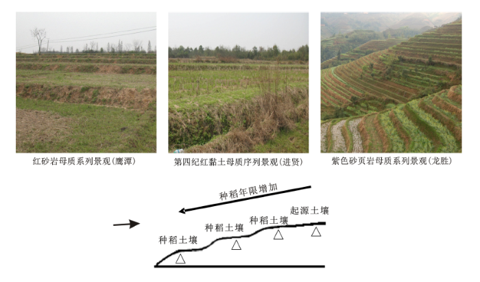
紫色砂页岩(PS)、第四纪红黏土(RC)和红砂岩(RS)母质是中国南方较为常见的成土母质。因此,选择这3种母质发育的水稻土时间序列为研究对象,该时间序列主要表现为梯级稻田,广泛分布于南方丘陵山区,多依地势修筑,是一种典型的地表水型水稻土。依据植稻难易和地方文献记载,与村寨临近的坡底土壤由于水分条件较好、土层较厚、距离村寨近而一般最先被开垦为稻田(此处土壤的种稻历史约等于建寨历史),之后逐步向上开垦,形成了由坡底向坡顶种稻年限逐渐变短的水耕人为土序列。共选择了3个研究区(图1):广西龙胜各族自治县(龙脊梯田)(25°50′ N、110°10′ E,年均气温18.2℃,年降水量1 557 mm,PS母质)、江西省鹰潭市(28°15′ N、116°55′ E,年均气温17.6℃,年降水量1 795 mm,RS母质)和进贤县(28°15′N、116°20′E,年均气温17.3℃,年降水量为1 549 mm,RC母质)。
图1 研究区样点分布与采样设计
Fig.1 Study area and sampling design for three paddy soil chronosequences
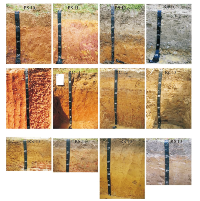
时间序列的建立和相关描述见文献[10]。土壤种稻年限是基于地形部位结合已调查的土壤种稻年限与当地村寨历史综合判定[10,11],之后又基于Harden[12]提出的剖面发育指数和Carré和Jacobson[13]提出的属性距离进行验证[11]。每个时间序列选择4个土壤剖面按发生层采集土样(采样设计见图1,剖面描述见表1,剖面照片见图2)。所有土壤样本均在水稻(Oryza sativa)收割后采集,土壤剖面选在稻田的中心部位,坡底剖面避开容易积水的洼地。3个研究区的年均温度和降水量相差不大,且人为水耕改变了成土因素,会大大减小气候对土壤发生的影响[6],因此本研究可认为气候对3个研究区水稻土发生的影响作用基本一致,不再单独讨论。
图2 不同母质水稻土时间序列的土壤剖面照片
Fig.2 Chronosequence photos of soil profiles of paddy soils in parent material
土壤样品在室内自然风干后,挑出枯枝落叶、根系及大于2 mm非土壤物质,过10 目尼龙筛。称取过筛土样10~20 g,通过沉降法分离土壤的砂粒、粉粒和黏粒。具体是用30 %的H2O2去除有机质后,加入10 mL 0.5 mol/L的NaOH分散剂振荡24 h分散样品。然后将样品通过300 目筛分离出砂粒(>50 μm),烘干称重。粉粒与黏粒承接于1 000 mL的高脚烧杯,根据斯笃克斯定律用沉降虹吸分离法分离出粉粒(2~50 μm)与黏粒(<2 μm),然后用蒸馏水洗净、离心浓缩,在 40℃烘箱中烘干后称重、磨细。
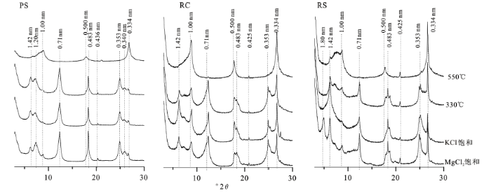
用 DCB 溶液去除黏粒的Fed,然后分别用1 mol/LMgCl2(加甘油)和1 mol/LKCl饱和,最后制片进行 XRD分析,具体方法参见《土壤调查实验室分析方法》[14],并根据各特征衍射峰的强度对黏粒矿物组成进行半定量估计。测试仪器为:德国BRUKER公司D8 ADVANCE 型仪器进行X-射线衍射分析(XRD);测试条件为:CuKa (λ = 0.15406 nm) 辐射,测试电压40 kV,测试电流40 mA,扫描方式为步进扫描,扫描速度为10˚/min,步长0.02˚。
MgCl2(甘油)饱和片的衍射曲线上(图3),1.0 nm、0.5 nm、0.33 nm处(个别峰和其它峰重叠)均出现衍射峰,KCl饱和处理与加温处理后峰仍存在,说明样品中存在伊利石(PS、RC和RS 序列)。MgCl2饱和片的衍射曲线上0.7 nm、0.35 nm处均出现较强衍射峰,KCl饱和处理与加温300℃峰形没有明显变化,加温到550℃时衍射峰消失,说明样品存在高岭石(PS、RC和RS 序列)。尽管如此,0.7 nm和1.0 nm处的衍射峰峰形较宽,这表示也有其它矿物存在。为了避免出现争议,本研究用高岭石类似矿物和伊利石类似矿物分别表示0.7 nm和1.0 nm衍射峰指示的矿物。在MgCl2饱和片的衍射曲线上,1.42 nm处出现较强衍射峰,KCl饱和片加温到300℃,1.42 nm峰向1.0 nm方向收缩移动,加温到550℃时1.42 nm峰收缩成不对称的1.0 nm峰,说明样品并不含绿泥石与蛭石,该峰主要指示1.4 nm过渡矿物(PS、RC和RS 序列)。MgCl2饱和片衍射曲线上0.48 nm处出现较强衍射峰,但加温300℃峰形没有变化说明样品并不含三水铝石,应为三羟铝石(PS、RC和RS 序列)。KCl饱和片加温到550℃时存在0.43 nm与0.33 nm处均出现衍射峰,说明样品含有石英矿物(PS,RC和RS 序列)。MgCl2饱和片的衍射曲线上1.8 nm处出现较强衍射峰,KCl饱和处理后收缩到1.0 nm处,说明该峰主要指示蒙脱石(RS 序列)。对于PS序列来说,部分土壤样本在1.2 nm处存在一个额外的衍射峰(KCl饱和处理加温到550℃时衍射峰消失),这表明样品可能有低结晶度的伊利石存在。另外该衍射峰在KCl饱和处理与加温300℃时峰形向低角度倾斜,这表明样品可能也有一定量的次生绿泥石存在。同样,部分土壤样本在0.34 nm处也存在一个额外的衍射峰(KCl饱和处理加温到550℃时衍射峰消失)。考虑到0.7 nm处的宽峰,这表明可能有埃洛石或低结晶度的高岭石存在。
图3 3种母质水稻土黏土矿物的鉴定
Fig.3 Identification of clay minerals in paddy soil chronosequences
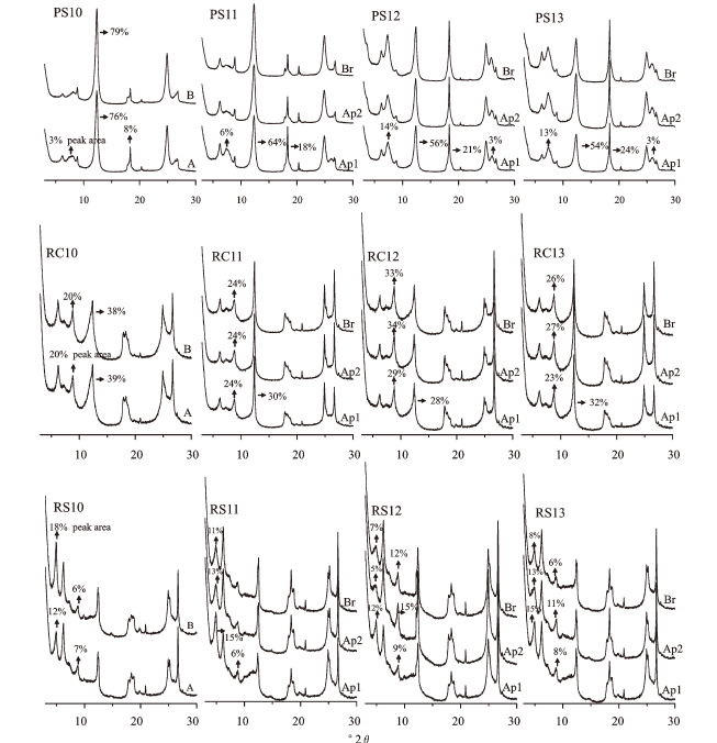
图4 不同母质水稻土典型时间序列黏粒矿物的XRD分析图谱
Fig.4 The XRD characteristic of clay minerals in paddy soil chronosequences
从图4可以看出同母质土壤(包括起源土壤和种稻土壤)之间的黏粒矿物衍射图谱很相似,不同母质土壤之间的衍射图谱差异较明显。PS母质起源土壤的黏粒矿物以高岭石类似矿物为主(0.7 nm),相对含量超过了75%,种稻后黏粒矿物有较规律的变化。基本上随着种稻年限的增加高岭石类似矿物的相对含量降低,低结晶度的伊利石或次生绿泥石(1.2 nm)与三羟铝石相对含量增加。RC母质起源土壤以高岭石类似矿物、三羟铝石、伊利石类似矿物为主,RS母质起源土壤以1.4 nm过渡矿物、高岭石类似矿物与三羟铝石为主。这2种母质的种稻土壤与起源土壤相比伊利石类似矿物相对含量略有增加。但总体上种稻后黏粒矿物的变化没有PS母质明显。另外,种稻土壤剖面内部各发生层间的黏粒矿物非常相似,基本没有明显差异。相比而言,一些种稻土壤剖面各发生层之间的形态特征已有非常明显的分异(图2)。这表明在水稻土剖面形态发育过程中黏粒矿物相对稳定,这使得利用黏粒矿物来指示水稻土的物源存在可能。
主要根据3种母质土壤的黏粒矿物组分数据,选择相对含量最大的3种矿物为端元做出矿物组分的三角端元图。在本研究中,高岭石类似矿物、三羟铝石、伊利石类似矿物的平均含量最高,分别为38.7%、15.7 %和12.6 %。下面以这3种矿物为端元,作出矿物组分的三角端元图(1.4 nm过渡矿物的平均含量为11.8%,与伊利石类似矿物接近,也做出了高岭石类似矿物、三羟铝石与1.4 nm过渡矿物的三角端元图)。从图5上可以看出不同母质土壤(包括自然土壤与水稻土)黏粒矿物的投影位置有明显的差异。虽然因所选矿物的不同,3种母质土壤黏粒矿物的投影位置有所差异,但同一母质土壤黏粒矿物的投影都集中分布在一个较小的范围内,通过黏粒矿物组分的三角端元图可以清楚的区分3种不同母质起源的水稻土。
图5 不同母质土壤黏粒矿物组分端元图
Fig.5 The triangular map with the three representative clay minerals for paddy soil chronosequences
伊利石结晶度经常用其(001)衍射峰半峰宽来表征(Kübler指数),本文也用1.0 nm衍射峰的半峰宽来表征伊利石类似矿物的结晶度(由于PS系列样本伊利石类似矿物含量极低,就不再计算其结晶度)。伊利石的结晶度通常与伊利石形成的气候环境条件直接相关[15],因此,其结晶度经常被用来反映沉积物的风化强度与指示气候环境变化[16]。在RC与RS起源土壤中伊利石类似矿物的结晶度一般小于0.40°,而在种稻土壤中一般都大于0. 40°,种稻后其结晶度变差。这可能主要因为周期性的淹水代表着较强的水解作用,这会引起黏粒矿物晶格有序度和晶体颗粒大小的变化等。
水稻土的发育过程不仅受自然成土因素影响,还受人为活动(耕作、施肥等)的强烈影响,其黏粒矿物的演化有自己独特的特点。本研究中这3种母质土壤黏粒矿物的变化大体可分为2种情况。RC与RS母质的起源土壤种稻后,土壤黏粒矿物的变化相对较小,甚至出现“逆风化”现象(伊利石类似矿物相对含量有一定增加)(图4)。这可能主要与K肥的持续施用有关。已有研究表明耕作措施下长期不施K肥可降低土壤表层的伊利石含量,而长期施K肥可提高土壤的伊利石含量[17~19]。这样看来,土壤黏粒矿物发挥了重要的缓冲作用:当土壤K素不足时,黏粒矿物会释放一部分K素来供应植物生长;当土壤K素充足时,黏粒矿物则会储存一部分K素。但XRD衍射结果同时显示RC与RS系列土壤的伊利石类似矿物并没有随种稻年限的增加而一直增加,这说明土壤黏粒矿物对K素的缓冲作用可能是有限的。需要特别指出的是这两种母质种稻土壤的黏粒含量较其起源土壤有明显的降低(表1),这种黏粒损失会引起土壤矿质养分的损失。这也可能是为什么RC和RS系列种稻土壤的伊利石类似矿物相对含量增加,但某些种稻土壤剖面(RC13、RS12和RS13)的全K含量较起源土壤却是降低的(表1)。PS母质的起源土壤种稻后,土壤黏粒矿物变化相对较大,表现为高岭石类似矿物相对含量降低,低结晶度的伊利石或次生绿泥石与三羟铝石相对含量增加。一般而言,种稻土壤的机械淋溶、还原淋溶、络合淋溶、铁解淋溶等过程都会造成一部分黏粒损失[6]。尽管如此,PS母质种稻土壤的黏粒含量较起源土壤却有一定的增加(表1)。物质输入或黏粒自生(转化和螯生等)通常会补偿土壤黏粒的损失。当土壤新补充的黏粒含量大于损失的,则表现为上升,反之,则表现为下降。就丘陵区的水稻土而言,最主要的外部成土因素为淹水稻作,且淹水时土壤均处于较强的淋溶过程,可认为外部的成土因素类似。因此PS母质种稻土壤黏粒的增加可能主要是黏粒自生(转化和螯生等)引起的。低结晶度的伊利石或次生绿泥石与三羟铝石等黏粒矿物的增加,使得高岭石类似矿物的相对含量降低,并使得土壤黏粒含量增加。但这并不意味着黏粒损失在PS土壤序列中是受到抑制的,而只是新成的黏粒总量大于损失的。PS母质发育的土壤全K含量相对较高,种稻后全K含量有明显的降低,脱K现象明显。但从其黏粒矿物的变化来看,在种稻土壤的脱K过程中,黏粒矿物并没有明显的脱K。这说明PS母质种稻土壤的脱K作用主要集中在非黏粒部分(原生矿物)。水稻土发育过程中这种原生矿物的脱K作用对土壤黏粒含量和黏粒矿物的类型都有较大影响,今后需加强这方面的研究。
表1 剖面样点的基本信息
Table 1 Descriptions of the studied soil profiles
| 剖面编号 | 位置 | 利用方式 | 种稻年限 | 坡度 | 海拔 | 黏粒 | 全钾 | 土壤类型 |
|---|---|---|---|---|---|---|---|---|
| (a) | (°) | (m) | (%) | (g/kg) | ||||
| PS10 | 坡顶 | 荒地 | 0 | 23 | 1 104 | 13.41±0.30 | 32.04±1.12 | 酸性紫色湿润雏形土 |
| PS11 | 坡顶 | 双季稻 | 约30 | 23 | 1 099 | 15.27±1.59 | 31.24±1.17 | 水耕淡色潮湿雏形土 |
| PS12 | 坡中 | 双季稻 | 100~300 | 36 | 935 | 19.82±4.00 | 21.55±1.71 | 普通铁聚水耕人为土 |
| PS13 | 坡底 | 双季稻 | 约300 | 28 | 807 | 15.75±3.02 | 22.54±0.33 | 普通铁聚水耕人为土 |
| RC10 | 坡顶 | 荒地 | 0 | <6 | 52 | 40.20±2.17 | 13.71±1.17 | 普通黏化湿润富铁土 |
| RC11 | 坡顶 | 油菜(Brassica campestris)-水稻 | 约100 | <6 | 45 | 32.94±8.66 | 14.17±2.98 | 普通铁聚水耕人为土 |
| RC12 | 坡中 | 油菜-水稻 | 100~300 | <6 | 34 | 30.24±3.32 | 15.12±0.5 | 普通铁聚水耕人为土 |
| RC13 | 坡底 | 油菜-水稻 | 约300 | <6 | 32 | 25.85±2.34 | 12.68±0.68 | 普通铁聚水耕人为土 |
| RS10 | 坡顶 | 荒地 | 0 | <6 | 63 | 18.24±6.03 | 9.71±4.52 | 普通酸性湿润雏形土 |
| RS11 | 坡顶 | 油菜-水稻 | 约30 | <6 | 48 | 9.68±3.91 | 13.07±6.28 | 水耕淡色潮湿雏形土 |
| RS12 | 坡中 | 油菜-水稻 | 60~200 | <6 | 38 | 12.42±5.92 | 6.01±1.25 | 普通铁聚水耕人为土 |
| RS13 | 坡底 | 油菜-水稻 | 约200 | <6 | 36 | 8.06±3.91 | 9.00±5.45 | 普通铁聚水耕人为土 |
本研究结果同时表明起源土壤的黏粒矿物通常会被水稻土所继承,它们的主要组分在水稻土发育过程中相对稳定,可以用黏粒矿物来指示起源土壤(或母质)的物源。由于黏粒矿物有一定的向下移动性,利用黏粒矿物的三角端元图判断剖面内的母质均一性时一定要特别小心,也可尝试结合移动性差的粉粒矿物来综合判定。
1) RC与RS母质的起源土壤种稻后,土壤黏粒矿物的变化相对较小,伊利石类似矿物相对含量有所增加,这可能主要与K肥的持续施用有关。
2) PS母质的起源土壤种稻后,土壤黏粒矿物变化相对较大,表现为高岭石类似矿物相对含量降低,低结晶度的伊利石或次生绿泥石与三羟铝石相对含量增加。PS母质发育的土壤种稻后脱K现象明显,脱K作用主要集中在原生矿物部分。这种原生矿物的脱K作用对土壤黏粒含量和黏粒矿物的类型有较大影响。
3) 起源土壤的黏粒矿物通常会被水稻土所继承,它们的主要组分在水稻土发育过程中相对稳定,可以用黏粒矿物来指示起源土壤(或母质)的物源。
The authors have declared that no competing interests exist.
| [1] |
Loss of K-bearing clay minerals in flood-irrigated, rice-growing soils in Jiangxi Province, China [J]. |
| [2] |
Pedogenic evolution of paddy soils in different soil landscapes [J].https://doi.org/10.1016/S0016-7061(03)00072-7 URL 摘要
Paddy soils are Hydragric Anthrosols and are an important soil resource for food production. They are widely distributed in China and Asia. Soils that can be used for paddy cultivation vary considerably but basically are grouped into three kinds of landscape, i.e., well-drained sloping uplands, alluvial plains with groundwater fluctuation, and poorly drained polder areas with a near-surface water table. Typical soil chronosequences were studied to clarify the pedogenic changes after wetland rice cultivation, especially in relation to management practices. All of them are in important rice production regions of China. The study focussed on redox condition and iron oxides dynamics. On alluvial plains, the soil conditions range from continuously reducing controlled by high groundwater to alternating reduction and oxidation because of artificial submergence and groundwater fluctuations. Artificially induced leaching losses, previously prevented by a high groundwater table, are partly compensated during paddy cultivation by the rejuvenation process of alluvial deposition. Soils on an older delta, which no longer receives river-sediments, are more strongly developed and showed a decrease of DCB-extractable iron in surface horizon of young paddy soils and more profoundly throughout the profile in old paddy soils. In the polder area, the apparent lowering of groundwater table by deposition of sediment has changed the soil hydrology and increased redox potential. With the better soil aeration, crystalline iron oxides and their ratio to total iron increase with cultivation age. On well-drained terraces, the change of soil moisture regime is overwhelming. Previously well-aerated upland soils are periodically reduced, which accelerates leaching and loss of iron oxides from surface horizons, and probably clay decrease by lateral movement and ferrolysis processes superimposed on the difference of parent soils. An iron-enriched subsurface horizon has formed rapidly and it is a diagnostic feature of this type of paddy soil.
|
| [3] |
|
| [4] |
Chronosequential changes of selected pedogenic properties in paddy soils as compared with non-paddy soils [J].https://doi.org/10.1016/j.geoderma.2009.03.016 URL 摘要
A series of paddy and non-paddy soil profiles that are developed in chronosequences from approximately 50 to 1000 years of exposure time on fairly uniform marine deposits under nearly identical landscape and climate conditions were sampled from Cixi, Zhejiang Province, China, where rice has been traditionally grown under water submergence. Master horizons were identified and sampled. Selected p...
|
| [5] |
Soil characteristic response times and pedogenic thresholds during the 1000-year evolution of a paddy soil chronosequence [J].https://doi.org/10.2136/sssaj2011.0006 Magsci [本文引用: 1] 摘要
A paddy soil chronosequence consisting of five profiles derived from calcareous marine sediments with cultivation history from 0 to 1000 yr was studied to assess the dynamic changes in soil properties and major elemental mass balance during soil evolution and to understand the response rates of soil properties at different time scales. The threshold concept was applied to increase our understanding of paddy soil genesis processes. Results showed that 50 yr of paddy cultivation induced measurable accumulation of soil organic C (SOC) in the surface horizon and marked reduction of magnetic susceptibility (MS), soft isothermal remanent magnetization (IRMs), and Ca, Mg, and Na elemental concentrations. Complete removal of CaCO(3) from profiles, measurable profile differentiation of free Fe oxide (Fe(d)) and total Fe, clay illuviation, reduction of hard isothermal remanent magnetization (IRM(s)), and net losses of elemental P and Mn occurred during the 300- to 700-yr time period. Soil clay mineral composition and Si, Al, and K elemental concentrations showed little change in 1000 yr. Th e rapid changes in SOC, MS, IRMs, Ca, Na, and Mg within 50 yr primarily resulted from anthropogenic activities, which are extrinsic thresholds. Th e noticeable changes in horizon differentiation of Fed, clay illuviation, and the decrease in IRM(h) during the 300- to 700-yr time period indicate threshold values for carbonate, which is an intrinsic threshold. In conclusion, our data demonstrate that different soil components and properties have different transformation processes and associated rates influenced by anthropogenic activities and the soil carbonate status of the original soil.
|
| [6] |
|
| [7] |
Erosional response of South China to arc rifting and monsoonal strengthening: a record from the South China Sea [J].https://doi.org/10.1016/S0025-3227(01)00301-2 URL [本文引用: 1] 摘要
Ocean Drilling Program sampling of the distal passive margin of South China at Sites 1147 and 1148 has yielded clay-rich hemipelagic sediments dating to 32 Ma (Oligocene), just prior to the onset of seafloor spreading in the South China Sea. The location of the drill sites offshore the Pearl River suggests that this river, or its predecessor, may have been the source of the sediment in the basin, which accounts for only ~1.8% of the total Neogene sediment in the Asian marginal seas. A mean erosion depth of ~1 km over the current Pearl River drainage basin is sufficient to account for the sediment volume on the margin. Two-dimensional backstripping of across-margin seismic profiles shows that sedimentation rates peaked during the middle Miocene (11-16 Ma) and the Pleistocene (since 1.8 Ma). Nd isotopic analysis of clays yielded values of -7.7 to -11.0, consistent with the South China Block being the major source of sediment. More positive values during and shortly after rifting compared to later sedimentation reflect preferential erosion at that time of more juvenile continental arc rocks exposed along the margin. As the drainage basin developed and erosion shifted from within the rift to the continental interior values became more negative. A rapid change in the clay mineralogy from smectite-dominated to illite-dominated at ~15.5 Ma, synchronous with middle Miocene rapid sedimentation, mostly reflects a change to a wetter, more erosive climate. Evidence that the elevation of the Tibetan Plateau and erosion in the western Himalaya both peaked close to this time supports the suggestion that the Asian monsoon became much more intense at that time, much earlier than the 8.5 Ma age commonly accepted.
|
| [8] |
evolution over the past 2 million years [J].https://doi.org/10.1016/S0025-3227(03)00213-5 URL 摘要
Clay mineral assemblages at ODP Site 1146 in the northern South China Sea are used to investigate sediment source and transport processes and to evaluate the evolution of the East Asian monsoon over the past 2 Myr. Clay minerals consist mainly of illite (22–43%) and smectite (12–48%), with associated chlorite (10–30%), kaolinite (2–18%), and random mixed-layer clays (5–22%). Hydrodynamic and mineralogical studies indicate that illite and chlorite sources include Taiwan and the Yangtze River, that smectite and mixed-layer clays originate predominantly from Luzon and Indonesia, and that kaolinite is primarily derived from the Pearl River. Mineral assemblages indicate strong glacial–interglacial cyclicity, with high illite, chlorite, and kaolinite content during glacials and high smectite and mixed-layer clay content during interglacials. During interglacials, summer enhanced monsoon (southwesterly) currents transport more smectite and mixed-layer clays to Site 1146 whereas during glacials, enhanced winter monsoon (northerly) currents transport more illite and chlorite from Taiwan and the Yangtze River. The ratio (smectite+mixed layers)/(illite+chlorite) was adopted as a proxy for East Asian monsoon variability. Higher ratios indicate strengthened summer-monsoon winds and weakened winter-monsoon winds during interglacials. In contrast, lower ratios indicate a strongly intensified winter monsoon and weakened summer monsoon during glacials. Spectral analysis indicates the mineral ratio was dominantly forced by monsoon variability prior to the development of large-scale glaciation at 1.2 Myr and by both monsoon variability and the effects of changing sea level in the interval 1.2 Myr to present.
|
| [9] |
Detrital fine-grained sediment contribution from Taiwan to the northern South China Sea and its relation to regional ocean circulation [J].https://doi.org/10.1016/j.margeo.2008.08.003 URL [本文引用: 1] 摘要
Results of clay mineralogy in 140 samples collected in major rivers and lakes in southwestern Taiwan and on the seafloor off Taiwan in the northeastern South China Sea (SCS), combined with clay mineral records of the Pearl River drainage basin, rivers in Luzon, and the South China shelf and slope, are used to semiquantitatively evaluate the detrital fine-grained sediment contribution of Taiwan to the northern SCS. The clay mineral assemblage of the Taiwan-sourced sediments consists dominantly of illite (average 56%) and chlorite (41%), with very scarce kaolinite and smectite. Their respective distribution from the rivers and lakes to the seafloor off Taiwan does not show obvious basin-wide differences. Linear correlations of illite chemistry index with illite crystallinity and of illite crystallinity with kaolinite (%) present two end-members of provenances, the Pearl River and Taiwan, for the South China shelf and slope. Assuming that kaolinite in the northern SCS is provided completely from the Pearl River, the contribution of Taiwan in clay minerals is evaluated as 29% to the South China shelf and 23% to the South China slope, respectively. Accordingly, the contribution of the Pearl River to the South China shelf and slope is 52% and 31%, respectively. The Luzon Arc accounts for the rest of clay mineral components for the northern SCS mainly by providing smectite. The Bashi Strait-crossed branches of the southward deep North Pacific Deep Water and the northward surface Kuroshio Current in the western Pacific may transport Taiwan-sourced suspended sediments westwards to the northern SCS.
|
| [10] |
Changes in magnetic properties and their pedogenetic implications for paddy soil chronosequences from different parent materials in South China [J].https://doi.org/10.1111/ejss.12050 URL Magsci [本文引用: 2] 摘要
It remains unknown whether there is a consistent relationship between magnetism dynamics and pedogenesis for paddy soils. In this study, three paddy soil chronosequences, derived from purple sandy shale (PS), Quaternary red clay (RC) and red sandstone (RS) in the hilly regions of south China, were studied to identify changes in magnetism during soil development and to understand their implications for pedogenesis. The results show that magnetic susceptibility (MS) and soft isothermal remanent magnetization (IRMs) simultaneously decreased to extremely small values in the anthrostagnic epipedons during the initial stages of cultivation. In contrast, this decrease was limited in the hydragric horizons of the young paddy soils and even increased in some. These changes suggest thatMS andIRM(s) can be enhanced by the oxidation of Fe2+ in acid paddy soils (betweenpH 5 and 6) or be depressed by anaerobic transformations of ferrimagnetic minerals. The main influence on magnetic properties was time duration and especially reducing degree of artificial submergence, while parent materials played a supportive role. Magnetic enrichments generally occurred in the clay fraction. Ferrimagnetic clay minerals were more easily altered than minerals in the silt and sand fractions. The study also shows that there was no fixed pattern in the relationship between magnetism and paddy pedogenesis and magnetic properties should be used with care when applying them to environments in which redox processes occur.
|
| [11] |
我国南方丘陵地区不同母质水耕人为土演变特征研究[D] .Pedogenesis of Hydragric Anthrosols chronosequences from different parent materials in South China. Nanjing: Institute of Soil Science, |
| [12] |
A quantitative index of soil development from field descriptions: Examples from a soil chronosequence in central California [J].https://doi.org/10.1016/0016-7061(82)90037-4 URL [本文引用: 1] 摘要
A soil development index has been developed in order to quantitatively measure the degree of soil profile development. This index, which combines eight soil field properties with soil thickness, is designed from field descriptions of the Merced River chronosequence in central California. These eight properties are: clay films, texture plus wet consistence, rubification (color hue and chroma), structure, dry consistence, moist consistence, color value, and pH. Other properties described in the field can be added when more soils are studied. Most of the properties change systematically within the 3 m.y. age span of the Merced River chronosequence. The absence of properties on occasion does not significantly affect the index. Individual quantified field properties, as well as the integrated index, are examined and compared as functions of soil depth and age.
|
| [13] |
Numerical classification of soil profile data using distance metrics [J].https://doi.org/10.1016/j.geoderma.2008.11.008 URL [本文引用: 1] 摘要
Quantitative grouping of soil layer descriptions into profile classes has not advanced much since the 1960s. Here we tackle the problem from pedological, utilitarian and joint points of view using an application, OSACA, that we have developed for the purpose. The program calculates the taxonomic distances between observed profiles based on layer (horizon) characteristics. Characteristics can be...
|
| [14] |
|
| [15] |
The Paleoclimatic interpretation of clay minerals insediment: A review [J].https://doi.org/10.1016/0012-8252(84)90055-2 URL [本文引用: 1] 摘要
The limitations imposed on the paleoclimatic interpretation of clay minerals in sediments are discussed on the basis of examples. The distinction between authigenic and detrital clay minerals is shown to be problematic, particularly with regard to smectite. The relationship between climatic parameters and clay-mineral formation is complicated by the intervention of extra-climatic factors such as topography, geomorphology, lithology and time. Post-depositional diagenetic changes may not be recognized. Differentiation during transport, due to size sorting or differential flocculation may overlap climate-induced differentiation. The association of clay-mineral assemblages with specific source areas presents difficulties due to dispersal pathways that are affected by type of transport agency, i.e., water, ice or wind. Transport agencies are not constant with time. By an interdisciplinary approach, with the paleoclimatic information derived from clay minerals being correlated with that obtained from the analysis of microfossils and oxygen isotope data, many of these limitations can be overcome.
|
| [16] |
浅谈利用黏土矿物重建古气候 [J].https://doi.org/10.3321/j.issn:0479-8023.2005.02.019 URL [本文引用: 1] 摘要
利用黏土矿物重建古气候近年来得到了广泛的应用,其分析测试方法较多.其中,X射线衍射分析主要用来确定黏土矿物组合及其含量以及某些黏土矿物的结晶度;化学分析、电镜分析主要用于黏土矿物的来源、成因、演变过程的研究;放射性同位素的研究使气候指标和年代学建立起时间和空间上的联系;而氢氧同位素分析亦能对古气候重建提供重要佐证.本文旨在综述各种研究方法所能提供和揭示蕴藏于黏土矿物中的古气候信息,以期全面综合地利用黏土矿物为手段来重建古气候.
An approach to paleoclimate-reconstruction by clay minerals. https://doi.org/10.3321/j.issn:0479-8023.2005.02.019 URL [本文引用: 1] 摘要
利用黏土矿物重建古气候近年来得到了广泛的应用,其分析测试方法较多.其中,X射线衍射分析主要用来确定黏土矿物组合及其含量以及某些黏土矿物的结晶度;化学分析、电镜分析主要用于黏土矿物的来源、成因、演变过程的研究;放射性同位素的研究使气候指标和年代学建立起时间和空间上的联系;而氢氧同位素分析亦能对古气候重建提供重要佐证.本文旨在综述各种研究方法所能提供和揭示蕴藏于黏土矿物中的古气候信息,以期全面综合地利用黏土矿物为手段来重建古气候.
|
| [17] |
Effect of potassium removal by crops on transformation of illitic clay minerals [J]. |
| [18] |
Dynamic role of "illite-like" clay minerals in temperate soils: facts and hypotheses [J].https://doi.org/10.1007/s10533-006-9054-2 Magsci 摘要
<a name="Abs1"></a>Analysis of new data and reinterpretation of published information for clay minerals found in temperate climate soil profiles indicates that there is often a gradient of “illite-like” clay minerals with depth. We used the term “illite-like” because these observations are based on X-Ray Diffractogram patterns and not on layer charge measurements which allow to define properly illite. It appears that “illite-like” layers are concentrated in the upper, organic - rich portion of the soil profile both under grassland and forest vegetation. “Illite-like” layer quantity seems directly related to soil potassium status. Indeed, intensive agriculture practises without potassium fertilization reduce “illite-like” content in surface soils, whereas several years of potassic fertilization without plant growth can increase “illite-like” content. The potassic soil clay mineral, illite, is particularly important in that it can be the major source of readily available potassium for plants. Spatial and temporal dynamics of clay minerals should be related to the potassium cycle. We propose that the frequently observed general trend of increasing exchangeable potassium in the top soil can be correlated with an increase in “illite-like” in the clays and that the decrease of potassium caused by intensive agricultural practices leads to “illite-like” layer destabilization. This vision of “illite-like” layer as a potassium reservoir refueled by plants and emptied by intensive cropping renews the concept of potassium availability and indicates a need to be discussed as well in natural ecosystems as in cultivated ecosystems.
|
| [19] |
Long-term fertilization influences on clay mineral composition and ammonium adsorption in a rice paddy soil [J].https://doi.org/10.2136/sssaj2007.0040 URL [本文引用: 1] 摘要
Increasing NH4+ adsorption can be an effective alternative in building an available N pool in soils to optimize crop recovery and minimize losses into the environment. We hypothesized that long-term fertilization may change NH4+ adsorption due to changes in the chemical and mineralogical properties of a rice (Oryza sativa L.) paddy soil. The objectives of this study were (i) to determine clay minerals in two soil clay size fractions using classical x-ray diffraction methods and a numerical diagram-decomposition method, (ii) to measure NH4+ adsorption isotherms before and after H2O2 oxidation of organic matter, and (iii) to investigate whether NH4+ adsorption is correlated with changes in soil chemical and mineral properties. The 23-yr long-term fertilization treatments caused little change in soil organic C (SOC) but a large variation in soil mineral composition. The whole-clay fraction (<5 mu m) corresponded more to the fertilization treatment than did the fine-clay fraction (<1 mu m) in terms of illite peak area percentage. The total vermiculite-chlorite peak area percentage was significantly correlated with the total illite peak area percentage (R = -0.9, P < 0.0001). Different fertilization treatments gave significantly different results in NH4+ adsorption. The SOC oxidation test showed positive effects of SOC on NH4+ adsorption at lower NH4+ concentration (<= 200 mg L-1) and negative effects at higher NH4+ concentration (300 mg L-1). The NH4+ adsorption by soil clay minerals after SOC oxidization accounted for 60 to 158% of that by unoxidized soils, suggesting a more important role of soil minerals than SOC on NH4+ adsorption. The NH4+ adsorption potential was significantly correlated to the amount of poorly crystallized illite present (P = 0.012). The availability of adsorbed NH4+ for plant growth needs further study.
|

/
| 〈 |
|
〉 |
