欧阳杰 , 彭华, 罗晓莹
Ouyang Jie, Peng Hua, Luo Xiaoying
中图分类号: Q948.2
文献标识码: A
文章编号: 1000-0690(2017)10-1585-08
通讯作者:
收稿日期: 2016-11-29
修回日期: 2017-02-13
网络出版日期: 2017-10-20
版权声明: 2017 《地理科学》编辑部 本文是开放获取期刊文献,在以下情况下可以自由使用:学术研究、学术交流、科研教学等,但不允许用于商业目的.
基金资助:
作者简介:
作者简介:欧阳杰(1969-),男,安徽蚌埠人,博士,副教授,主要从事旅游景区开发与管理、丹霞地貌、会展旅游等方面研究。E-mail:910432328@qq.com
展开
摘要
以广东丹霞山狮子岩—阳元山景区为研究地,以国家珍稀濒危保护植物丹霞梧桐(Firmiana danxiaensis)的空间分布为研究内容,通过实地考察获取其空间分布的数据(经纬度、海拔、坡度和坡向等),利用ArcGIS10.0在精度为1 m的DEM地形数据上进行空间分析,总结丹霞梧桐空间分布的微地貌环境特征。研究发现:① 研究区丹霞梧桐主要分布在海拔180 m等高线穿过坡度60º附近的土壤比较贫瘠的垂直节理或水平层理比较发育的崖壁上,并与圆叶小石积(Osteomeles subrotunda)、忽地笑(Lycoris aurea)、卷柏(Selaginella tamariscina)等植物伴生,属于比较耐旱的崖壁植物;② 丹霞梧桐的空间分布不受坡向因素的严格制约,坡度和海拔是影响丹霞梧桐分布的2个重要因素。根据以上分布规律,可以推测180 m等高线穿过坡度60º地带的丹霞山其他崖壁地带,亦可能会有丹霞梧桐的分布,并建议在目前已经发现丹霞梧桐分布比较集中的狮子岩东南坡,设立国家珍稀濒危保护植物丹霞梧桐重点保护带。
关键词:
Abstract
The core areas Shiziyan-Yangyuanshan of Danxiashan of Guangdong Province are selected to study the spatial distribution of Firmiana danxiaensis which are the national rare and endangered plants. The micro-landforms environmental features of spatial distribution of Firmiana danxiaensis are summarized through the data (longitude, altitude, slope and aspect) which obtained by the investigation on-the-spot, and the space analysis on the DEM terrain data with 1 m resolution by using ArcGIS10.0. From the spatial distribution and slope morphology of Danxia, the Firmiana danxiaensis in the study areas are mainly distributed at the Danxia cliffs with vertical joints or horizontal beddings and the altitude of 180 m or so and the 60ºslope with relative barren soil where always can be found some plants such as Osteomeles subrotunda, Lycoris aurea, Selaginella (revive grass), etc. They all belong to drought to lerant plants. The spatial distribution of Firmiana danxiaensis is not restricted by the factor of the aspect, but the slope and the altitude are the two important influencing factors. According to the above distribution rules, the Firmiana danxiaensis presumably distribute at the cliffs of the Danxiashan outside of the study areas with the altitude of 180 m and the slope 60º. We actively recomned that it is necessary to establish the important protected belt for the Firmiana danxiaensis of the national rare and endangered plants in the southeast of Shiziyan of Danxiashan as early as possible. Our study is useful for comparing with the other five China Danxia World Natural Heritage sites (Taining of Fujian Province, Chishui of Guizhou Province, Longhushan-Guifeng of Jiangxi Province, Langshan of Hunan Province, Jianglangshan of Zhejiang Province). We can analyze and summarize the spatial distributions and environmental characteristics of micro landforms related to the national rare and endangered plants, and establish China Danxia World Natural Heritage key protection belts in the future.
Keywords:
自徐祥浩等[1]于1987年首次发现新种丹霞梧桐(Firmiana danxiaensis)以来,关于丹霞梧桐的研究主要集中在梧桐科植物在全球和中国的宏观分布[2,3],丹霞梧桐群落的地理区系成分分析[4],以及丹霞梧桐遗传多样性等领域[5,6]。但是,关于丹霞梧桐的数量及其空间分布微地貌环境特征、广东丹霞山丹霞梧桐重点保护带界定与划分的研究还不多。研究区广东丹霞山是丹霞地貌的命名地,目前,在丹霞地貌研究领域内,关于丹霞地貌空间分布、丹霞山顶与山谷的生态效应等方面的研究成果比较多[7~14],丹霞地貌(尤其是微地貌)与植被的关系研究较少。
广东丹霞山(介于113°36′15″E~113°46′40″E和24°51′49″N~25°03′36″N之间)由于地处南岭山脉中段南麓这一特殊的地理位置,使其成为南北植被的天然分界线。丹霞山既是许多热带种类自然分布的北界,也是很多暖温带种类分布的南界。从中国植物分区的大空间来看,丹霞山位于“中国-日本森林植物亚区”中“华南地区”的北部[15]。丹霞山植被类型丰富多样,是重要的植物种源基地和物种基因库[16]。加之其独特的丹霞地貌形态[17~19],致使区内保存了大量孑遗种、珍稀濒危物种。这些珍稀濒危植物,是全人类的共同财富,它们在揭示物种起源、系统进化、遗传育种、生殖生态,以及了解古地质、古气候等方面均具有重要意义[20,21] 。所以,当务之急是要查明国家珍稀濒危保护植物丹霞梧桐的数量,总结丹霞梧桐空间分布的微地貌环境特征,并在丹霞山丹霞梧桐分布比较密集的地方设立丹霞梧桐重点保护地带。
丹霞梧桐在“中国物种红色目录”(CSRL,2004)第一卷评估中被列为极危(CR)等级[22],是国家Ⅱ级重点保护野生植物,属于落叶小乔木,每年6月左右开紫花,雄花花药15枚,雌花子房近球形,种子圆球形,淡黄褐色,其花朵艳丽,树形优美,是优美的观赏植物。丹霞梧桐树皮黑褐色,嫩枝圆柱形,青绿色,无毛。树叶近圆形,薄革质,顶端浑圆,基部心形。每年10月左右树叶变黄后脱落,是进行野外调查与识别,找出其空间分布地带的最佳时机。
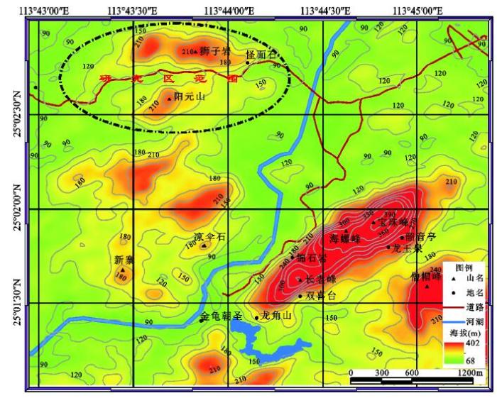
选取丹霞山狮子岩—阳元山景区(图1)为研究区,在实地考察获取丹霞梧桐的数目、丹霞梧桐空间分布范围及海拔高程等数据的基础上,与丹霞山1 m分辨率的DEM数据叠加,利用ArcGIS10.0空间分析模块,归纳总结丹霞梧桐在研究区范围内分布的坡度、坡向等微地貌环境特征,根据这些微地貌环境参数,对研究区范围外丹霞山其他地方可能会有丹霞梧桐分布的地带进行推测。
图1 研究区狮子岩-阳元山在丹霞山的位置与范围示意图
Fig.1 The position and the scope of the study area of the Shiziyan-Yangyuanshan on the Danxiashan Mountain
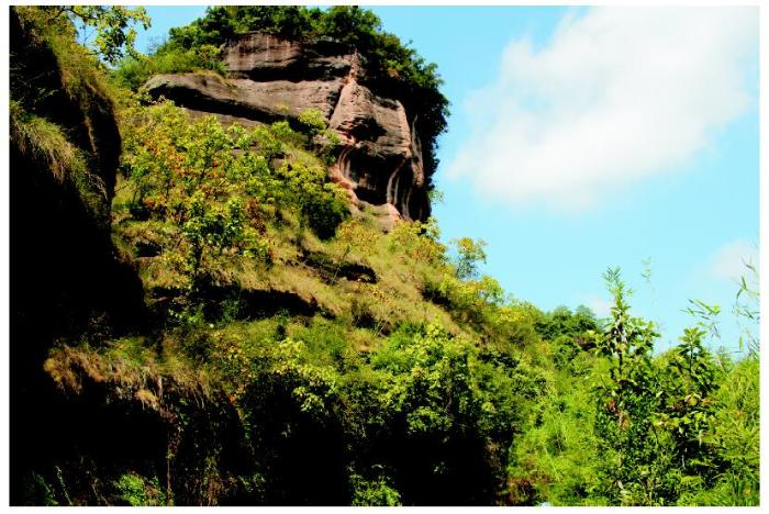
为明确研究区丹霞梧桐的数量及空间分布,笔者及研究团队先后于2016年1月(表1)、6月、10月2~24日多次赴丹霞山实地考察、拍照(2 650多幅)、GPS定位(180多处)等。已获得狮子岩-阳元山景区丹霞梧桐的数量(约157株),部分照片如图2所示。其数量统计如下:狮子岩南坡-东南坡一带126株:其中,阳元山票站附近10株;怪面石附近60株;阳元石入口附近20株;入口西侧崖壁一带23株;通泰桥路口3株;玄机台对面崖壁10株。 阳元山一带31株:其中,玄机台下部崖壁20株;西坡放鹤池附近崖壁10株;九九天梯南侧1株。
图2 狮子岩东南坡崖壁上丹霞梧桐树叶变黄最佳观测期照片(拍摄于2016年10月23日广东省中国丹霞山世界地质公园)
Fig.2 The yellow leaves of the Firmiana danxiaensis of the southeast cliff of the Shiziyan during the best observation period
通过对丹霞山植被群落的初步调查(表1)发现,在丹霞山顶和山麓地带丹霞梧桐极少分布,反而在丹霞崖壁上,丹霞梧桐成群散布较多。这可能是因为在景区的山顶和山麓地带,受到较多的人类活动影响,加之其他植物难于在丹霞崖壁上生存,故研究区的丹霞崖壁为丹霞梧桐的生存和发育提供了相对有利的空间。
表1 丹霞山丹霞坡面植被情况
Table 1 The plants surveyed at the Danxia slope on the Danxiashan Mountain
| 编号 | 经度(E) | 纬度(N) | 坡面形态、坡向 | 海拔(m) | 植被群落 |
|---|---|---|---|---|---|
| DXS-160601 | 113.755º | 25.035º | 山坡、西北坡 | 390 | 低矮灌丛、植物密集,主要有乌冈栎(Quercus phillyraeoides)、金竹(Phyllostachys sulphurea)、圆叶小石积、仙草(Mesona chinensis)等。土壤颜色较黑,颗粒细腻,较干燥,含较多植物残体,上覆杂草。 |
| DXS-160602 | 113.748º | 25.033º | 宝珠峰山顶 | 395 | 山顶矮林,主要有山黄皮(Clausena excavata)、白桂木(Artocarpus hypargyreus)、网脉山龙眼(Helicia reticulata)等,灌丛明显稀少。土壤颜色较黑、松散,上覆杂草、较干燥。 |
| DXS-160603 | 113.747º | 25.032º | 山坡、东南坡 | 384.4 | 金竹林,土壤可能含有密花树(Myrsine seguinii)、山黄皮等树种的花粉。土壤颜色较黑、上覆杂草、松软。 |
| DXS-160604 | 113.746º | 25.031º | 山脊、北向 | 363.8 | 亚热带常绿阔叶林,平均高20 m,灌丛一般以木荷(Schima superba)、樟(Cinnamomum camphora)为主。土色浅黑,质地松软。 |
| DXS-160605 | 113.743º | 25.03º | 山坡、东坡 | 381.1 | 亚热带针阔混交林,以马尾松(Pinus massoniana)、樟、木荷、黄杞(Engelhardtia roxburghiana)四大类为主,高20~35 m。 |
| DXS-160606 | 113.74º | 25.028º | 山顶、东向 | 351.3 | 山顶灌丛,以乌饭树(Vaccinium bracteatum)、乌冈栎、映山红(Rhododendron simsii)、飞龙掌血(Toddalia asiatica)、石楠(Photinia serrulata)等为主。 |
| DXS-160607 | 113.738º | 25.027º | 山坡、西坡 | 360 | 亚热带常绿阔叶林,以杜英(Elaeocarpus decipiens)、樟、黄杞、秀丽锥(Castanopsis jucunda)为主。 |
| DXS-160608 | 113.736º | 25.024º | 山坡、东南坡 | 309 | 毛竹(Phyllostachys heterocycla)林地。 |
| DXS-160609 | 113.742º | 25.05º | 山麓崩岩 | 174 | 崩岩表层苔藓。 |
| DXS-160610 | 113.743º | 25.05º | 山麓岩壁 | 168 | 岩壁表面苔藓。 |
| DXS-160611 | 113.747º | 25.023º | 山坳平地 | 113.8 | 草本植物密集,以芦苇(Phragmites australis)、朝天罐(Osbeckia opipara)、莎草(Cyperus glomeratus)、鳞毛蕨属(Dryopteris)、禾本科(Gramineae)植物为主。沼泽地,2条溪流汇合处,土壤含水量大。 |
| DXS-1606012 | 113.747º | 25.021º | 山麓谷地 | 125 | 孝顺竹(Bambusa multiplex)林地。沼泽地,沟谷长约1 km,面积较大。 |
| DXS-1606013 | 113.743º | 25.02º | 山麓 | 140 | 乔木稀少,以灌木、草本为主,有毛鳞省藤(Calamus thysanolepis)、粤柳(Salix mesnyi)等。沼泽地,土层发育较厚。 |
| DXS-1606014 | 113.744º | 25.02º | 山坡、东北向 | 153 | 亚热带针阔混交林,以灌木、芒萁(Dicranopteris pedata)、马尾松、木荷、两广杨桐(Adinandra glischroloma)、山茶(Camellia japonica)等为主。 |
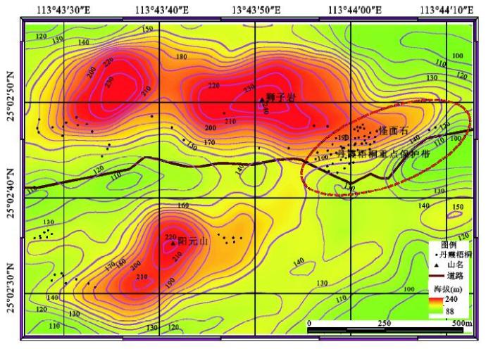
为了准确分析丹霞梧桐在研究区分布的海拔范围,本研究使用ArcGIS10.0的空间分析模块3D Spatial Tools工具中的Raster Surface-Contour List功能,在精度为1 m的DEM地形数据中提取特征等高线,通过等高线数据判读发现,狮子岩东南坡和南坡的丹霞梧桐基本沿着海拔180 m等高线分布,其中东南坡丹霞梧桐分布密集地带的海拔高度最低在110 m左右,研究区丹霞梧桐分布的海拔高度一般不超过220 m等高线(图3)。
图3 研究区丹霞梧桐分布海拔
Fig.3 The altitude to the distribution of the Firmiana danxiaensis in the study area
利用ArcGIS10.0的空间分析模块3D Spatial Tools工具中的Raster Surface-slope功能,在精度为1 m的DEM地形数据中计算研究区的坡度,结合实际观察发现,研究区坡度在60°以上的崖壁地带丹霞梧桐分布较多(图4)。实地观察还发现,海拔180 m等高线穿过坡度60°的崖壁有节理或层理发育的地带,丹霞梧桐分布往往比较集中。
图4 研究区丹霞梧桐分布坡度
Fig.4 The slope to the distribution of the Firmiana danxiaensis in the study area
通过ArcGIS10.0的空间分析模块3D Spatial Tools工具中的Raster Surface-aspect功能,在精度为1 m的DEM地形数据中计算研究区的坡向,发现在狮子岩东南-南坡一带岩壁,丹霞梧桐分布比较密集,在阳元山的北坡和西坡,也有丹霞梧桐小范围聚集散布(图5)。以上分析表明,研究区的坡向不是严格制约丹霞梧桐空间分布最重要的微地貌因素。根据以上对狮子岩-阳元山丹霞梧桐空间分布的海拔、坡度和坡向的地貌环境分析,可以推测在丹霞山本次研究区以外的长老峰景区、翔龙湖景区以及其他尚未开发的地带,在海拔180 m等高线穿过坡度大于60°崖壁的相似微地貌环境地带,也可能会有丹霞梧桐的分布,这为下一步全面重点考察丹霞山丹霞梧桐的数量及其空间分布奠定研究基础。
图5 研究区丹霞梧桐分布的坡向
Fig.5 The aspect to the distribution of the Firmiana danxiaensis in the study area
但是,等高线180 m穿过坡度大于60°的地带,只是丹霞梧桐比较适宜生长发育的丹霞微地貌环境特征,这并不意味着所有符合这2个条件的丹霞崖壁上都会布满丹霞梧桐。实际上,影响丹霞梧桐分布的其他非地貌因素还很多,也很复杂。比如,区域的气温、降水、湿度、光照、成土母质及其土壤属性等因素,都会对丹霞梧桐的分布造成不同程度的影响。甚至丹霞崖壁形成的时间对丹霞梧桐的分布都会有影响。如果丹霞崖壁形成的时间较晚,丹霞崖壁岩性均一且无节理或层理发育,加之外力雨水冲刷迅速,致使在这样的丹霞崖壁上很难保存下来丹霞梧桐或者其他植物的种子,导致这些丹霞崖壁上形成寸草不生的“裸岩”。这样的情况在丹霞山很多,典型的地方有锦石岩寺的赤壁丹崖和阳元山北坡的晒布岩等“裸岩”崖壁。
以上分别从丹霞坡面形态、海拔、坡度和坡向等方面,分析了丹霞梧桐空间分布的微地貌环境特点。反之,微地貌环境又会影响甚至制约植物的生长和发育,使其和环境相适应。最主要表现是,为了能够适应在比较贫瘠的崖壁上生存,丹霞梧桐的树干挺拔,根系特别发达,这样既能够固定本身的生长发育,接受阳光照射,同时,还能最大限度的吸收水分并存活下来。丹霞梧桐是比较耐旱的小乔木,主要沿着丹霞崖壁节理或层理处土壤稀薄贫瘠的地方分布。尤其值得注意的是,丹霞梧桐分布地带经常见到的圆叶小石积、忽地笑、卷柏等植物,也基本都具备耐旱、较低矮、根系发达等特征,这充分反映了在相似的微地貌环境的制约下,植物适应环境生存的趋同性。
1) 丹霞梧桐属于比较耐旱的崖壁植物,在研究区的空间分布是主要沿着阳元山-狮子岩景区崖壁的节理或层理处成群聚集,在山顶和山麓地带分布较少。在研究区狮子岩的东南、南坡崖壁海拔在180 m左右、坡度大于60°且有垂直节理和水平层理发育、土壤相对比较贫瘠的岩壁地带,丹霞梧桐集中分布,并与圆叶小石积、忽地笑、卷柏等植物伴生。
2) 基于本文总结的丹霞梧桐空间分布规律,可以推测在丹霞山坡度60°左右,180 m等高线穿过的有节理或层理发育、土壤比较贫瘠的崖壁地带,可能会有丹霞梧桐的分布,实际情况亟待进一步的深入调查和验证。积极建议在狮子岩东南坡丹霞梧桐密集分布地带,尽快建立丹霞山国家珍稀濒危物种丹霞梧桐重点保护地带(如图3~5所示),以宣传珍稀物种保护的重要性,增强民众的保护意识。
3) 当研究较大范围丹霞山(核心区168 km2)国家珍稀濒危保护植物(如丹霞梧桐)的空间分布规律时,在研究手段上,需要将实地考察与卫星遥感、信息识别与提取技术相结合。根据植被的季节变化特点(丹霞梧桐在每年6月份开紫花以及10月份叶子变黄这2个不同于其他植物的显著特征),辅助于无人机低空高分辨信息获取、识别与算法研究,既能准确快速的提取丹霞梧桐空间分布的范围,又能定量分析和计算丹霞梧桐的数量以及空间分布的微地貌环境参数等,使丹霞地貌的研究,向着定量、微观的纵深领域发展。
通过对广东丹霞山国家珍稀濒危保护植物丹霞梧桐分布的坡面形态、海拔、坡度、坡向等微地貌环境特征的研究,不仅可以推测本次研究区之外更大范围区域丹霞梧桐分布的可能地带,还可以和中国丹霞另外5处世界自然遗产地(福建泰宁、贵州赤水、江西龙虎山-龟峰、湖南崀山、浙江江郎山)的国家珍稀濒危保护植物的空间分布及其微地貌环境特点进行对比、分析和总结,为建立和划分中国丹霞世界自然遗产地国家珍稀濒危植物保护带奠定基础。
致谢:感谢广州图灵遥感技术中心提供丹霞山高精度DEM数据、丹霞山管委会协助和支持此项研究及配合野外调查工作!
The authors have declared that no competing interests exist.
| [1] |
中国梧桐科植物的新种和新变种 [J].
本文报道中国梧桐科3个新分类群:丹霞梧桐生长于广东丹霞山,生于石山山坡上,有时也栽种作观赏植物;元江苹婆生长于云南元江县;野生苹婆生长于广西西南部石灰岩山上常绿林中。
New species and variety of Sterculiaceae from China.
本文报道中国梧桐科3个新分类群:丹霞梧桐生长于广东丹霞山,生于石山山坡上,有时也栽种作观赏植物;元江苹婆生长于云南元江县;野生苹婆生长于广西西南部石灰岩山上常绿林中。
|
| [2] |
梧桐科植物的地理分布 [J].https://doi.org/10.3969/j.issn.1005-3395.2001.1.004 URL [本文引用: 1] 摘要
Sterculiaceous plants in the world are estimated to be 1 546 species in 60 genera, which distribute mainly in the tropics and subtropics with a few in temperate regions. Sterculiaceae is a large and multiform family, and the attribution of some genera has still no identical views. Based on J. Hutchinson's system and some references, an adjustment of the position of some genera in the family has been made, and 12 tribes in the family are classified. The distribution of Sterculiaceae plants in the world is included in 6 kingdoms with 23 regions,based on Takhtajan’s floristic regions.In this paper 99 species with 7 varieties in 25 genera of Stercul iaceae in China, including 85 wild species with 7 varieties in 18 genera and 14 cultivated species in 8 genera are considered. Main characters of the l2 tribes and the distribution of genera are described.The authers suggest that Stercnllaceae originated beforeCretaceus period,i.e.before the separation of Gondwana, because fossil plants had been found in Africa ,Europe ,Asia and America.According to the modern distribution pattern of Stercnliaceae,many genera till now distribute in Madagascar and tropical Africa which are endemic,and the mole primitive tribe ,Dembeyeae,mainly distributes here.It is suggested that Madagascar and tropical Africa might be the origin of Sterculiaceae from where expanded to Eurasia,Australia and America. A distribution map of Sterculiaceae in the world is given The genera with the number of species grown in 23 provinces and regions of China are tabulated.
Geographical distribution of Sterculiaceae. https://doi.org/10.3969/j.issn.1005-3395.2001.1.004 URL [本文引用: 1] 摘要
Sterculiaceous plants in the world are estimated to be 1 546 species in 60 genera, which distribute mainly in the tropics and subtropics with a few in temperate regions. Sterculiaceae is a large and multiform family, and the attribution of some genera has still no identical views. Based on J. Hutchinson's system and some references, an adjustment of the position of some genera in the family has been made, and 12 tribes in the family are classified. The distribution of Sterculiaceae plants in the world is included in 6 kingdoms with 23 regions,based on Takhtajan’s floristic regions.In this paper 99 species with 7 varieties in 25 genera of Stercul iaceae in China, including 85 wild species with 7 varieties in 18 genera and 14 cultivated species in 8 genera are considered. Main characters of the l2 tribes and the distribution of genera are described.The authers suggest that Stercnllaceae originated beforeCretaceus period,i.e.before the separation of Gondwana, because fossil plants had been found in Africa ,Europe ,Asia and America.According to the modern distribution pattern of Stercnliaceae,many genera till now distribute in Madagascar and tropical Africa which are endemic,and the mole primitive tribe ,Dembeyeae,mainly distributes here.It is suggested that Madagascar and tropical Africa might be the origin of Sterculiaceae from where expanded to Eurasia,Australia and America. A distribution map of Sterculiaceae in the world is given The genera with the number of species grown in 23 provinces and regions of China are tabulated.
|
| [3] |
梧桐科植物在中国的地理分布 [J].https://doi.org/10.3969/j.issn.1000-3142.2002.06.004 URL [本文引用: 1] 摘要
对中国梧桐科植物的地理分布进行研究 ,指出中国梧桐科植物的分布区 ,东起台湾的北部 (1 2 2°1 0′E) ,西至西藏的墨脱 (95°3 0′E ,2 9°2 0′N) ,北起河北的东陵和小五台山 (约 40°2 0′N) ,南达西沙群岛的永兴岛(约 1 6°1 0′N)。其分布范围主要在热带、亚热带 ,只有少数种类可分布到温带。主要根据《中国种子植物属的分布区类型》的划分原则 ,把中国梧桐科植物野生各属划分为 1 0个类型。且对中国梧桐科植物一些属的分布格局进行探讨。
The distribution of the sterculiaceous plants in China. https://doi.org/10.3969/j.issn.1000-3142.2002.06.004 URL [本文引用: 1] 摘要
对中国梧桐科植物的地理分布进行研究 ,指出中国梧桐科植物的分布区 ,东起台湾的北部 (1 2 2°1 0′E) ,西至西藏的墨脱 (95°3 0′E ,2 9°2 0′N) ,北起河北的东陵和小五台山 (约 40°2 0′N) ,南达西沙群岛的永兴岛(约 1 6°1 0′N)。其分布范围主要在热带、亚热带 ,只有少数种类可分布到温带。主要根据《中国种子植物属的分布区类型》的划分原则 ,把中国梧桐科植物野生各属划分为 1 0个类型。且对中国梧桐科植物一些属的分布格局进行探讨。
|
| [4] |
极小种群植物丹霞梧桐群落的地理区系成分分析 [J].Analysis on geographical elements of the community of plant species with extremely small populations Firmina danxiaensis. |
| [5] |
Development and characterization of microsatellite marks from the transcriptome of Firmiana danxiaensis (Malvaceae) [J].https://doi.org/10.3732/apps.1300047 URL PMID: 4103115 [本文引用: 1] 摘要
61Firmiana consists of 12-16 species, many of which are narrow endemics. Expressed sequence tag (EST)-simple sequence repeat (SSR) markers were developed and characterized for size polymorphism in four Firmiana species. 61A total of 102 EST-SSR primer pairs were designed based on the transcriptome sequences of F. danxiaensis; these were then characterized in four Firmiana species-F. danxiaensis, F. kwangsiensis, F. hainanensis, and F. simplex. In these four species, 17 primer pairs were successfully amplified, and 14 were polymorphic in at least one species. The number of alleles ranged from one to 13, and the observed and expected heterozygosities ranged from 0 to 1 and 0 to 0.925, respectively. The lowest level of polymorphism was observed in F. danxiaensis. 61These polymorphic EST-SSR markers are valuable for conservation genetics studies in the endangered Firmiana species.
|
| [6] |
Low genetic diversity and weak population differentiation in Firmiana danxiaensis, a tree species endemic to Danxia landform in northern Guangdong,China [J].https://doi.org/10.1016/j.bse.2014.02.029 URL [本文引用: 1] 摘要
Danxia landform, a unique type of petrographic geomorphology, sporadically occurs in southern China. There are about 400 rare or threatened plants and animals in this landform, but little information on genetic aspects of these species has been available. Of them, Firmiana danxiaensis is a dominant tree species endemic to Mount Danxia, a typical Danxia landform in northern Guangdong, China. In this study, we examined genetic diversity and population structure of F. danxiaensis , in comparison with two other narrowly distributed Firmiana species, Firmiana hainanensis and Firmiana kwangsiensis , which grow in non-Danxia-landform regions. Nine microsatellite markers were used to investigate genetic diversity and differentiation in a total of 256 individuals from nine populations of F. danxiaensis , three of F. hainanensis , and one of F. kwangsiensis . The results showed that F. danxiaensis had the lowest genetic diversity ( H E =0.364卤0.019) among the three species, but weak population structure similar to another Firmiana species ( F ST =0.042 and 0.020, respectively). This low genetic diversity observed in F. danxiaensis is possibly due to confined natural distribution range and strong selective pressure in soils of Danxia landform, which may also be true for other endemic species in Danxia landform. For the long term survival of these endemic species, habitat conservation and anthropogenic introduction to similar habitats such as the adjacent Danxia landform areas should be two major strategies.
|
| [7] |
中国丹霞地貌空间分布探讨 [J].Spatial distribution of Danxia landforms in China. |
| [8] |
浙江方岩丹霞地貌类型及其空间组合 [J].https://doi.org/10.3321/j.issn:0375-5444.2009.03.010 URL 摘要
浙江方岩突出的丹霞地貌类型有围谷、方山、峰丛、石柱和凹槽等,它们的空间组合沿着北西—南东方向有规律的排列:西北部五峰书院一带的凹槽和岩穴发育典型,中部鸡鸣峰、桃花峰等处分布有大量的新鲜崩积石,东南部石鼓寮的石鼓、石柱尤为突出,在峰丛与平原交汇的东、南和西三侧被围谷所环绕。这种组合体现了随着构造隆升,在以外力作用为主的不断"雕塑"下,丹霞地貌的发育一般经历了差异风化、重力崩塌、流水侵蚀搬运,完成地貌循环侵蚀的过程,期间孕育了绚丽多姿的丹霞地貌,它们主要发育于早白垩世晚期的方岩组(K1f)冲积扇—扇前辫状河相岩层中。其中,岩性的差异风化规律和辫状河相沉积的特点,可以通过对三个样点的实验数据分析加以证实。方岩丹霞地貌是在我国申报世界自然遗产丹霞地貌区中"青年期"类型的突出代表,符合申报世界自然遗产中具有突出、普遍的美学和科学价值的理由。
Types and spatial combination of Danxia landform of Fangyan in Zhejiang Province, China. https://doi.org/10.3321/j.issn:0375-5444.2009.03.010 URL 摘要
浙江方岩突出的丹霞地貌类型有围谷、方山、峰丛、石柱和凹槽等,它们的空间组合沿着北西—南东方向有规律的排列:西北部五峰书院一带的凹槽和岩穴发育典型,中部鸡鸣峰、桃花峰等处分布有大量的新鲜崩积石,东南部石鼓寮的石鼓、石柱尤为突出,在峰丛与平原交汇的东、南和西三侧被围谷所环绕。这种组合体现了随着构造隆升,在以外力作用为主的不断"雕塑"下,丹霞地貌的发育一般经历了差异风化、重力崩塌、流水侵蚀搬运,完成地貌循环侵蚀的过程,期间孕育了绚丽多姿的丹霞地貌,它们主要发育于早白垩世晚期的方岩组(K1f)冲积扇—扇前辫状河相岩层中。其中,岩性的差异风化规律和辫状河相沉积的特点,可以通过对三个样点的实验数据分析加以证实。方岩丹霞地貌是在我国申报世界自然遗产丹霞地貌区中"青年期"类型的突出代表,符合申报世界自然遗产中具有突出、普遍的美学和科学价值的理由。
|
| [9] |
湖南崀山丹霞地貌岩体抗酸脆弱性的实验研究 [J].https://doi.org/10.11867/j.issn.1001-8166.2011.09.0965 URL Magsci 摘要
<p>湖南崀山拥有独特的丹霞喀斯特现象,但具有溶蚀力的水对丹霞地貌区重要的物质基础砂岩和砾岩的侵蚀还没有进行过深入的实验研究。以此为切入点,通过实地采样获得41块砂岩、砾岩岩芯,选择其中18块岩芯平均分成3组,分别放入2%、5%、10% 3种不同浓度的H<sub>2</sub>SO<sub>4</sub>溶液中浸泡并连续12天定时观测、记录,最后把未破碎的3块砾岩岩芯进行单轴抗压实验,其抗压强度在9.6~13.7 MPa之间,仅为这些岩体干抗压强度的1/10左右。通过4处采样地的实验数据对比还发现,崀山砾岩抗酸侵蚀后的抗压强度是最低的,如果遭到同样外力的破坏,崀山丹霞岩体更容易破损倒塌。以上岩芯抗酸侵蚀的脆弱性和岩芯的物质组成、结构等有关。在宏观实验观测的基础上,初步微观半定量分析解释了丹霞地貌区砂岩和砾岩抗酸侵蚀脆弱性的一般特点,为今后更加合理地保护崀山丹霞地貌提供依据。</p>
Experimental research on vulnerability of Danxia rocks to resistance against acid erosion in Langshan, Hunan Province. https://doi.org/10.11867/j.issn.1001-8166.2011.09.0965 URL Magsci 摘要
<p>湖南崀山拥有独特的丹霞喀斯特现象,但具有溶蚀力的水对丹霞地貌区重要的物质基础砂岩和砾岩的侵蚀还没有进行过深入的实验研究。以此为切入点,通过实地采样获得41块砂岩、砾岩岩芯,选择其中18块岩芯平均分成3组,分别放入2%、5%、10% 3种不同浓度的H<sub>2</sub>SO<sub>4</sub>溶液中浸泡并连续12天定时观测、记录,最后把未破碎的3块砾岩岩芯进行单轴抗压实验,其抗压强度在9.6~13.7 MPa之间,仅为这些岩体干抗压强度的1/10左右。通过4处采样地的实验数据对比还发现,崀山砾岩抗酸侵蚀后的抗压强度是最低的,如果遭到同样外力的破坏,崀山丹霞岩体更容易破损倒塌。以上岩芯抗酸侵蚀的脆弱性和岩芯的物质组成、结构等有关。在宏观实验观测的基础上,初步微观半定量分析解释了丹霞地貌区砂岩和砾岩抗酸侵蚀脆弱性的一般特点,为今后更加合理地保护崀山丹霞地貌提供依据。</p>
|
| [10] |
丹霞山顺层洞穴风化特征的试验研究 [J].URL 摘要
This study focuses on the bedding caves developed in the 2nd Member of the Danxia Formation at Danxia Basin. Investigations of differential weathering of red bed rocks were conducted, especially the weathering features of soft interlaid rock layers and how this weathering effects the development of the bedding caves. Based on field investigations, three bedding caves were selected as study cases, followed by a collection of rock samples with different lithologies, as well as interlayer ground water samples, for laboratory test and analysis. The data reveals that primary factors for bedding cave formation at Mt. Danxiashan are the different lithological characters of rock layers in the cave wall and the rapid weathering and erosion of soft interlaid rock layers. Soft interlaid rocks between layers generally belong to silty mudstone with high content of clay minerals and argillaceous cements. Due to strong absorbability, high porosity and low compressive strength, these soft rocks are vulnerable to weathering and easily broken into smaller pieces. The overlying and underlying rock layers are more resistant sandstones or sandy conglomerates, cemented mainly by calcite and iron oxides, with low porosity and higher compressive strength. During the weathering process of rock layers in bedding caves, factors that are responsible for the disintegration of rocks include the expansion and contraction of clay minerals, dissolution of calcareous cements, and hydration of iron oxides. However, the dominant factors contributes rock decay vary in different lithotypes. For silty mudstones, the repeated expansion and contraction of clays is a significant cause of weathering. As for the weathering of sandstones and sandy conglomerates, the dissolution of calcareous cements plays a more important role. In addition, the infiltration of acid rainwater can also accelerate the weathering processes by ion displacement with minerals in red bed rocks.
Experimental study on the weathering features of bedding caves at Mt. Danxiashan. URL 摘要
This study focuses on the bedding caves developed in the 2nd Member of the Danxia Formation at Danxia Basin. Investigations of differential weathering of red bed rocks were conducted, especially the weathering features of soft interlaid rock layers and how this weathering effects the development of the bedding caves. Based on field investigations, three bedding caves were selected as study cases, followed by a collection of rock samples with different lithologies, as well as interlayer ground water samples, for laboratory test and analysis. The data reveals that primary factors for bedding cave formation at Mt. Danxiashan are the different lithological characters of rock layers in the cave wall and the rapid weathering and erosion of soft interlaid rock layers. Soft interlaid rocks between layers generally belong to silty mudstone with high content of clay minerals and argillaceous cements. Due to strong absorbability, high porosity and low compressive strength, these soft rocks are vulnerable to weathering and easily broken into smaller pieces. The overlying and underlying rock layers are more resistant sandstones or sandy conglomerates, cemented mainly by calcite and iron oxides, with low porosity and higher compressive strength. During the weathering process of rock layers in bedding caves, factors that are responsible for the disintegration of rocks include the expansion and contraction of clay minerals, dissolution of calcareous cements, and hydration of iron oxides. However, the dominant factors contributes rock decay vary in different lithotypes. For silty mudstones, the repeated expansion and contraction of clays is a significant cause of weathering. As for the weathering of sandstones and sandy conglomerates, the dissolution of calcareous cements plays a more important role. In addition, the infiltration of acid rainwater can also accelerate the weathering processes by ion displacement with minerals in red bed rocks.
|
| [11] |
丹霞地貌沟谷生态效应 [J].
以广东省丹霞山为研究实例,探讨丹霞地貌特殊的沟谷生态效应。结果表明,丹霞地貌的特殊沟谷生态效应体现在以下两个方面:第一是丹霞地貌演变过程中形成了众多石峰隆起和沟谷凹陷,特殊的地貌环境使得沟谷中的生态因子与其它非丹霞地貌开阔区域产生差异,小气候相对封闭,水湿条件极好,为喜高温高湿的热带物种提供了较好的生存环境;沟谷所处位置的地理环境,如四周崖壁的光滑程度会影响到太阳光反射到沟谷的光强,这些都会对沟谷中的温湿度产生影响。第二是丹霞地貌特殊的生态条件,为沟谷地带孕育出一批热带性较强的分类群提供了可能,与相近纬度的诸多植被相比,丹霞地貌植物区系热带性明显增强,热带分布区类型所占比重比同纬度区域要大10%以上,大多数沟谷中热带性物种分布现象比较明显,藤本分布较多,蕨类植物也较丰富,耐水湿的植物区系发育良好;这实际上造成了植物水平分布上的移位,使中亚热带区域中分布有南亚热带甚至热带区域的物种,出现了由于其特殊的沟谷地貌效应而形成的与其地貌条件保持协调和平衡的演替顶级群落类型,称为地貌顶级群落。
The ecological ravine effects of Danxia landform.
以广东省丹霞山为研究实例,探讨丹霞地貌特殊的沟谷生态效应。结果表明,丹霞地貌的特殊沟谷生态效应体现在以下两个方面:第一是丹霞地貌演变过程中形成了众多石峰隆起和沟谷凹陷,特殊的地貌环境使得沟谷中的生态因子与其它非丹霞地貌开阔区域产生差异,小气候相对封闭,水湿条件极好,为喜高温高湿的热带物种提供了较好的生存环境;沟谷所处位置的地理环境,如四周崖壁的光滑程度会影响到太阳光反射到沟谷的光强,这些都会对沟谷中的温湿度产生影响。第二是丹霞地貌特殊的生态条件,为沟谷地带孕育出一批热带性较强的分类群提供了可能,与相近纬度的诸多植被相比,丹霞地貌植物区系热带性明显增强,热带分布区类型所占比重比同纬度区域要大10%以上,大多数沟谷中热带性物种分布现象比较明显,藤本分布较多,蕨类植物也较丰富,耐水湿的植物区系发育良好;这实际上造成了植物水平分布上的移位,使中亚热带区域中分布有南亚热带甚至热带区域的物种,出现了由于其特殊的沟谷地貌效应而形成的与其地貌条件保持协调和平衡的演替顶级群落类型,称为地貌顶级群落。
|
| [12] |
丹霞地貌山顶生态效应 [J].
首次探讨了丹霞地貌山顶生态效应现象,揭示特殊的地貌、形态所产生的特殊生态现象。测定广东省丹霞山宝珠峰和海螺峰的山顶的生态因子特征、群落结构特征和物种生态型特征,并与山脚的群落与种群以及相近非丹霞地貌区作比较。结果表明,山顶的平均温度高于山脚沟谷,平均湿度小于山脚沟谷,群落物种数和物种多样性均小于山脚沟谷。相比山顶而言,山脚沟谷的植物有很强的热带性。这些特征都有别于一般非丹霞地貌山地。另外,在山顶和山脚调查的几个种群在叶面积、比叶面积、树皮、枝下高和冠幅等方面,均出现了生态型的差异。讨论了丹霞地貌山顶对生态型研究、岛屿理论研究和适应性进化研究的科学意义。
The ecological effect on the hilltop of Danxia landform.
首次探讨了丹霞地貌山顶生态效应现象,揭示特殊的地貌、形态所产生的特殊生态现象。测定广东省丹霞山宝珠峰和海螺峰的山顶的生态因子特征、群落结构特征和物种生态型特征,并与山脚的群落与种群以及相近非丹霞地貌区作比较。结果表明,山顶的平均温度高于山脚沟谷,平均湿度小于山脚沟谷,群落物种数和物种多样性均小于山脚沟谷。相比山顶而言,山脚沟谷的植物有很强的热带性。这些特征都有别于一般非丹霞地貌山地。另外,在山顶和山脚调查的几个种群在叶面积、比叶面积、树皮、枝下高和冠幅等方面,均出现了生态型的差异。讨论了丹霞地貌山顶对生态型研究、岛屿理论研究和适应性进化研究的科学意义。
|
| [13] |
丹霞山风景地貌的植物区系研究 [J].https://doi.org/10.3969/j.issn.1000-3142.1999.01.002 URL 摘要
描述了丹霞山植物区系的特征,对其科、属、种进行系统分析,并与邻近地区植物区系作了对比研究,探讨了丹 霞地貌对本区植物区系组成成分的影响.丹霞山植物区系体现了华夏植物区系的特征,其表征科有不少同时也是华夏区系的表征科.从属的地理分布区类型来看,以 泛热带分布属的比例最高,其次为热带亚洲分布属、东亚分布属及北温带分布属.丹霞山植物区系相对其纬度来说热带性较强,这与其特定的地貌特征有关.另外, 本区的苔藓植物较为丰富,据初步统计共有27科70属,其中石生性苔藓分布尤其广泛.
A preliminary study on the flora of the tourist landform of Danxiashan, Guangdong, China. https://doi.org/10.3969/j.issn.1000-3142.1999.01.002 URL 摘要
描述了丹霞山植物区系的特征,对其科、属、种进行系统分析,并与邻近地区植物区系作了对比研究,探讨了丹 霞地貌对本区植物区系组成成分的影响.丹霞山植物区系体现了华夏植物区系的特征,其表征科有不少同时也是华夏区系的表征科.从属的地理分布区类型来看,以 泛热带分布属的比例最高,其次为热带亚洲分布属、东亚分布属及北温带分布属.丹霞山植物区系相对其纬度来说热带性较强,这与其特定的地貌特征有关.另外, 本区的苔藓植物较为丰富,据初步统计共有27科70属,其中石生性苔藓分布尤其广泛.
|
| [14] |
丹霞地貌的国内外研究对比 [J].
The term "Danxia Landform" was first identified and coined in China. Danxia Landform research in China is focused on primary theoretical research, scientific discussions of macro spatial distribution and qualitative description of the classification. New studies have recently been concerning quantitative,visualization and experimental research for Danxia Landform. Other countries do not currently refer to Danxia Landform as a reference for this unique type of landform very frequently, but foreign scholars have abundant research in sandstones, conglomerates, and red beds in micro, experiments, and quantitative areas. For comparisons with national and international research, Danxia Landforms should be applied as a primary example of macro and micro, qualitative and quantitative, theoretical and practical descriptions and analysis. It is instructive to use the term "Danxia Landform" as an acceptable international term when comparing and contrasting with other like landforms around the world.
A contrast introduction to Danxia landforms from a world wide references for similar landforms.
The term "Danxia Landform" was first identified and coined in China. Danxia Landform research in China is focused on primary theoretical research, scientific discussions of macro spatial distribution and qualitative description of the classification. New studies have recently been concerning quantitative,visualization and experimental research for Danxia Landform. Other countries do not currently refer to Danxia Landform as a reference for this unique type of landform very frequently, but foreign scholars have abundant research in sandstones, conglomerates, and red beds in micro, experiments, and quantitative areas. For comparisons with national and international research, Danxia Landforms should be applied as a primary example of macro and micro, qualitative and quantitative, theoretical and practical descriptions and analysis. It is instructive to use the term "Danxia Landform" as an acceptable international term when comparing and contrasting with other like landforms around the world.
|
| [15] |
丹霞山植被及其保护 [J].
本文通过实地调查,阐述了丹霞山的植物区系和主要植被类型,并对植被资源的保护和利用提出了建议。
The vegetation and its conservation in the Danxia mountains.
本文通过实地调查,阐述了丹霞山的植物区系和主要植被类型,并对植被资源的保护和利用提出了建议。
|
| [16] |
红石公园, 绿色宝库 [J].Red-stone park, green treasure house. |
| [17] |
广东丹霞山丹霞地貌类型空间分布初探 [J].Spatial distribution of types of Danxia landforms in Danxiashan, Guangdong Province. |
| [18] |
广东丹霞山崩岩空间分布的初步研究 [J].URL 摘要
通过实地考察发现,丹霞山崩岩空间分布密集地至少有三个区域:翔 龙湖南岸、腾蛇坳和锦石岩。其中,翔龙湖南岸以玉带桥为界,玉带桥以东的崩岩主要以砂岩为主,玉带桥以西的崩岩,砾岩的比重有所上升,在这个区域崩岩和崖 壁比照最典型的地方是仙居岩,其中仙居岩寺上方有一大型危岩发育,应引起高度警惕。腾蛇坳的崩岩主要是以砾岩为主,成群分布,规模大,岩体棱角较明显,以 拦门石和笔管榕附近的崩岩最为突出。锦石岩的崩岩主要分布在中下层景观的别传寺和锦石岩寺庙门前的通天洞等处,为目前丹霞山发现山体崩岩规模最大之地。丹 霞山核心区其他崩岩密集的地方,还需要进一步实地考察,收集信息,采集标本。
Spatial distribution of fallen stones in Danxiashan, Guangdong Province. URL 摘要
通过实地考察发现,丹霞山崩岩空间分布密集地至少有三个区域:翔 龙湖南岸、腾蛇坳和锦石岩。其中,翔龙湖南岸以玉带桥为界,玉带桥以东的崩岩主要以砂岩为主,玉带桥以西的崩岩,砾岩的比重有所上升,在这个区域崩岩和崖 壁比照最典型的地方是仙居岩,其中仙居岩寺上方有一大型危岩发育,应引起高度警惕。腾蛇坳的崩岩主要是以砾岩为主,成群分布,规模大,岩体棱角较明显,以 拦门石和笔管榕附近的崩岩最为突出。锦石岩的崩岩主要分布在中下层景观的别传寺和锦石岩寺庙门前的通天洞等处,为目前丹霞山发现山体崩岩规模最大之地。丹 霞山核心区其他崩岩密集的地方,还需要进一步实地考察,收集信息,采集标本。
|
| [19] |
中国丹霞世界自然遗产地地貌类型的对比研究 [J].
2009年8月1日在巴西首都巴西利亚召开的第34届世界遗产大会上,中国"丹霞"顺利通过评审,被列入世界遗产名录.中国"丹霞"系列包括广东丹霞山、湖南莨山、福建泰宁、浙江江郎山、江西龙虎山-龟峰、贵州赤水六个中国丹霞地貌景观最美的地方.本文通过实地考察其中五处世界自然遗产地,对比分析各地的凹槽、岩穴、崩积石、丹霞崖壁、峰丛、造型石等丹霞地貌类型特点.这些世界自然遗产地的丹霞地貌类型多样、姿态万千,是当地旅游开发、设计的基石.
Contrast study types of Danxia landforms in the World Natural Heritage sites of China Danxia.
2009年8月1日在巴西首都巴西利亚召开的第34届世界遗产大会上,中国"丹霞"顺利通过评审,被列入世界遗产名录.中国"丹霞"系列包括广东丹霞山、湖南莨山、福建泰宁、浙江江郎山、江西龙虎山-龟峰、贵州赤水六个中国丹霞地貌景观最美的地方.本文通过实地考察其中五处世界自然遗产地,对比分析各地的凹槽、岩穴、崩积石、丹霞崖壁、峰丛、造型石等丹霞地貌类型特点.这些世界自然遗产地的丹霞地貌类型多样、姿态万千,是当地旅游开发、设计的基石.
|
| [20] |
广东丹霞山表土孢粉研究的意义和价值 [J].The importance and the value of studying pollen in the topsoil in Danxiashan, Guangdong Province. |
| [21] |
|
| [22] |
|

/
| 〈 |
|
〉 |

