经雅梦 , 殷杰, 叶明武
Jing Yameng, Yin Jie, Ye Mingwu
中图分类号: P954
文献标识码: A
文章编号: 1000-0690(2018)11-1924-09
通讯作者:
收稿日期: 2017-11-21
修回日期: 2018-01-20
网络出版日期: 2018-11-20
版权声明: 2018 《地理科学》编辑部 本文是开放获取期刊文献,在以下情况下可以自由使用:学术研究、学术交流、科研教学等,但不允许用于商业目的.
基金资助:
作者简介:
作者简介:经雅梦(1993-), 女, 安徽宿州人, 硕士研究生, 主要从事城市自然灾害应急管理研究。E-mail: Jingym6@126.com
展开
摘要
以上海市外环以内中心城区作为研究区域,采用洪涝情景模拟与GIS网络分析相结合的研究方法,评估了当前以及未来不同重现期河流洪涝情景下城市公共安全(110)应急响应能力。研究结果表明:在洪涝情景下,部分城市路网瘫痪、交通中断,应急车辆无法通行,公安应急服务空间可达性范围较正常情况明显变小,应急响应能力降低;由于高脆弱性区域(棚户区)主要位于黄浦江沿岸地区,江水漫溢导致淹没路段较多,因此部分棚户区的救援时间会出现延迟甚至失去应急救援服务。通过对河流洪涝情景下城市公共安全(110)应急响应能力的评估研究,可为城市洪涝灾害应急响应部门制定预防与应对措施提供理论和科学依据,具有重要的现实意义。
关键词:
Abstract
In recent decades, in the context of global warming and rapid urbanization, increasing flood and waterlogging have resulted in a great threat to urban socio-economic development and public safety, and have been one of the hotpots in the field of natural hazards research. In this paper, the city center (within outer ring) of Shanghai, China has been selected as the study area. A simplified 1D/2D hydrodynamic model (FloodMap) was used to derive fluvial flood inundation associated with urban road network. Furthermore, GIS-based network analysis (New Service Area and New Closest Facility) was applied to evaluate the emergency responses accessibility of critical public service sectors (Public Safety 110) under normal and multiple scenarios of fluvial flooding (current state, 2030s and 2050s). The results show that, 1) at normal (smooth traffic) condition, emergency response service could cover almost the total research area, which could reach the majority (80%) of the study area within 15 minutes at the condition of extremely congested roads. 2) During 1 in 100 year flood scenario, part of the road network (mainly at the bank of Huangpu River) loses its capacity. As the interruption of the surrounding road network, the number of public security agency which lost the emergency response capability has also increased significantly. Among these, the most serious condition is of 22 police stations who lost emergency rescue capability, while the service area of emergency department have obviously decreased. 3) During 1 in 1000 year flood scenario, the response areas were further reduced than normal and about 1/6 of the public security organization lose their emergency response ability. Under the condition of traffic congestion, 30% of the central city couldn’t get emergency rescue. To conclude: in the flood situation, fluvial flooding have a serious influence on urban road network, leading to travel delays and disruption of emergency vehicles, along with emergency service, whose geographic coverage is smaller than normal. As the high vulnerability areas (shanty towns) mainly located in the Huangpu River floodplain, emergency response for some parts of this zone will be delay and even unreachable. The study suggests that the assessment of urban police (110) emergency response under fluvial flooding scenarios are proved to be practical, and will provide theoretical and scientific basis for formulating prevention and response measures.
Keywords:
受气候变暖、快速城镇化、地面沉降等因素影响,全球平均海平面迅速上升,部分地区强热带气旋活动频率增加[1,2]。根据IPCC第四次报告显示,全球变暖导致的最直接的威胁是风暴洪水等极端灾害事件增多[3],除了造成严重的房屋倒塌与人员伤亡外,还带来了道路交通中断、公共设施服务范围减小和应急响应时间延迟等间接影响[4,5]。例如,9711号台风适逢天文大潮,导致黄浦江沿岸潮位达到历史最大值,洪水沿江漫溢数十千米,多处防汛墙溃决,受灾人口超过15万人,经济损失约6.35亿元[6]。城市对气候变化的响应十分敏感,由于上海市是国家政治经济文化发展中心,人类活动强度较大,从而导致中心城区河道数大幅度减少,河道蓄水量也较之前减少超过80%,不透水面积增大,加之相对落后的排水系统,致使城市自身调节能力与应对突发洪涝的能力大大降低[4,7]。因此,开展城市洪涝灾害应急管理与防治工作对当前国家科学前沿问题的探讨与国家需求的发展具有重要意义。
21世纪以来,城市洪涝灾害发生频率呈上升趋势,逐渐成为公众和政府部门关注的焦点[8]。国内外学者利用洪涝数值模型与GIS路网分析技术研究了洪涝条件下各个研究区域内急救服务的可达性,Coles[9]及殷杰[7]等学者认为洪涝灾害对高脆弱性设施(如护理院、养老院)的应急响应可达性影响随重现期加大而增大;Green等[10]的研究表明暴雨洪涝对城市应急响应可达性的影响较河流洪水更为显著。
城市洪涝灾害应急响应能力评估是一项以预防为主的重要非工程措施,是灾害管理的重要组成部分,科学的开展洪涝灾害应急管理可产生巨大的经济效益、社会效益和环境效益[11]。因此,快速高效的提升公共服务设施应急响应能力是降低洪涝灾害引起的直接与间接影响的最有力保障。目前,对城市洪涝灾害应急响应的研究主要集中在理论与规划层面[8,12],部分研究关注城市路网淹没带来的交通中断、服务响应受损与应急疏散路径选择 [13,14,15,16],但缺少将洪涝模拟结果与交通路网结合以评估城市公共服务设施(医疗、公安、消防等)的应急响应能力的案例。以上海市外环以内中心城区作为研究区,利用ArcGIS网络分析工具集,并结合黄浦江河流洪涝淹没模拟结果与研究区路网,由此开展正常及不同重现期淹没情景下城市公共安全应急响应能力评估研究,从而充实和丰富城市洪涝灾害风险评估与管理体系,为洪涝灾害的预防和应对提供科学依据。
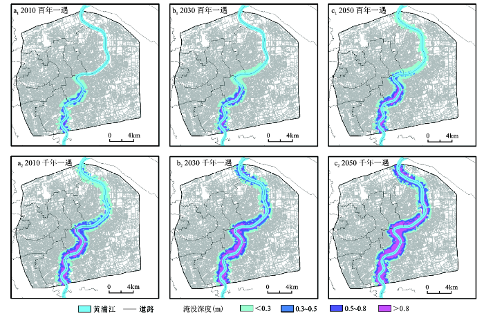
本研究所涉及的数据包括洪涝淹没模拟结果、路网交通数据、城市公共服务设施数据等。其中洪涝模拟结果采用前期研究中得到的黄浦江流域2010、2030、2050年百年一遇和千年一遇淹没范围和深度,并将中心城区淹没区裁出[17,18]。路网数据和城市公共服务设施数据均来自2013年上海市交通(高德)导航GIS数据集。根据研究需要,将中心城区路网数据裁出,其中包含约102 000个路段,属性列表中包含道路名称、功能、长度等基本信息,但缺少方向、道路等级、速度等研究所需信息,因此,需要对路网数据进一步处理。在ArcGIS 10.2软件中加载路网数据,参考谷歌地图的交通导向,添加道路方向属性列表,加入单双向设置;参考《中华人民共和国公路工程技术标准(JTG B01-2003)》[19]并结合上海市实际道路状况,把道路分为5个等级,最高限速分别设置为:高速公路120 km/h、快速路80 km/h、主干道60 km/h、次干道50 km/h、支路30 km/h。城市公共服务设施主要包括应急响应部门和公共服务机构,本研究选择公安110和城市中脆弱性较高的棚户区作为洪涝灾害应急响应服务的重点研究对象。通过对原始数据的筛选,保留256所具有应急出警能力的公安机构(派出所以上级别)和569处棚户区居民点作为研究对象。
本文采用洪涝数值模拟与GIS网络分析相结合的研究方法。首先,对不同重现期情景的洪涝模拟结果进行初步处理(图1),利用ArcGIS软件将洪涝淹没范围重分类,选取30 cm积水深度(大部分城市道路积水封路的标准)作为分类阈值[20],并把分类结果中积水深度高于阈值标准的洪涝淹没区域与上海市外环以内中心城区路网叠加,删除淹没路网即可得出不同重现期洪涝灾害的影响地区。其次,使用ArcGIS中Network Dataset工具对交通路网进行拓扑关系构建,利用Network Analyst工具集中服务域分析(New Service Area)功能,把每个110出警点和删除路段加载到服务域分析中作为设施点和线障碍,由此得出各公共安全服务设施点(110)的服务区域。考虑到110出警时可不受部分交通规则约束,因此本研究中未考虑红绿灯及转向等道路交通规则,由此计算出110急救在正常及不同重现期淹没情景下5、10、15 min(出警时间规定5~15 min)内所覆盖的服务范围。洪涝灾害应急响应能力评价的关键因素主要是基于路网分析的空间可达性及其服务范围[21,22],因此,本研究采用了GIS网路分析中最快路径算法(New Closest Facility,即两点之间时间最短),以积水深度小于30 cm的路网作为基础道路,模拟计算城市110急救点到各个棚户区所在位置的最短时间路径。参考《城市道路交通规划设计规范(GB50220-95)》[23],并结合城市中车辆在上下班高峰、晚间及日常等时间段行驶速度的差异,分别将道路行驶速度设置为最高限速S1、S2(S1的1/2)、S3(S1的1/4)3种类型以涵盖可能的城市道路交通状况,由此评估110急救的应急响应能力。
图1 上海市中心城区洪涝情景淹没模拟结果
Fig.1 Inundation extents and depths for flood scenarios in the city center of Shanghai City
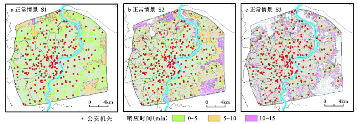
在正常条件(道路不受积水影响)下,由于中心城区内公安机关数量较多,几乎整个区域都可得到应急救援服务如图2和表1所示。在道路最高限速(交通畅通)S1情景下,110出警车辆在5 min内的服务面积占整个中心城区的89%,各公安机构服务区高度重叠,具有极高的应急响应能力。在正常交通情况(部分道路交通拥堵)S2下,5 min内110急救的应急响应服务范围减少到62%;15 min内可得到110急救服务的区域占整个中心城区面积的98%。在上下班交通高峰期(道路交通十分拥堵)S3条件下,车辆在15 min内无法到达的区域占中心城区总面积的20%。
图2 正常情况下城市110急救应急响应空间可达性与服务范围
Fig.2 Accessibility for police emergency service under normal conditions
表1 正常条件和洪涝情景下城市110急救应急服务范围
Table 1 Police emergency service areas under normal and flood scenarios
| 洪涝情景 | 5 min应急服务区(km2) | 10 min应急服务区(km2) | 15 min应急服务区(km2) | ||||||||
|---|---|---|---|---|---|---|---|---|---|---|---|
| 车速S1 | 车速S2 | 车速S3 | 车速S1 | 车速S2 | 车速S3 | 车速S1 | 车速S2 | 车速S3 | |||
| 正常情况 | 593 (89%) | 411 (62%) | 162 (24%) | 666 (100%) | 593 (89%) | 412 (62%) | 666 (100%) | 652 (98%) | 535 (80%) | ||
| 2010年百年一遇 | 580 (87%) | 403 (61%) | 160 (24%) | 649 (97%) | 580 (87%) | 404 (61%) | 653 (98%) | 635 (95%) | 523 (79%) | ||
| 2010年 千年一遇 | 546 (82%) | 375 (56%) | 143 (22%) | 604 (91%) | 546 (82%) | 376 (56%) | 607 (91%) | 597 (90%) | 492 (74%) | ||
| 2030年 百年一遇 | 574 (86%) | 399 (60%) | 156 (23%) | 643 (97%) | 574 (86%) | 399 (60%) | 648 (97%) | 628 (94%) | 517 (78%) | ||
| 2030年 千年一遇 | 530 (80%) | 363 (55%) | 140 (21%) | 582 (87%) | 531 (80%) | 364 (55%) | 583 (88%) | 576 (86%) | 477 (72%) | ||
| 2050年百年一遇 | 562 (84%) | 389 (58%) | 150 (23%) | 631 (95%) | 563 (85%) | 390 (58%) | 636 (95%) | 617 (93%) | 508 (76%) | ||
| 2050年千年一遇 | 519 (78%) | 354 (53%) | 135 (20%) | 569 (85%) | 520 (78%) | 355 (53%) | 570 (86%) | 563 (85%) | 468 (70%) | ||
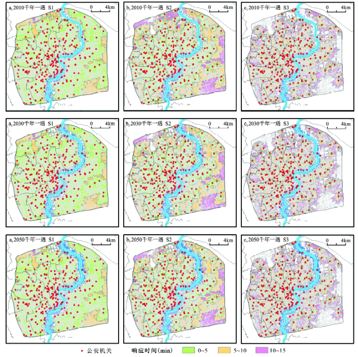
百年一遇洪涝情景下,道路积水深度超过30 cm,外滩以南徐汇、黄浦和浦东新区等沿黄浦江两岸区域部分道路无法通行,随着洪水淹没范围不断扩大,淹没区内失去服务功能的110急救点也不断增多,2010、2030和2050年分别有5、7和22个公安机构失去应急响应能力。在当前情况(2010年)下,因洪涝淹没导致的110急救服务范围比正常条件下减少低于20 km2 ,约占总面积的3%,影响相对较小。到2030和2050年,在理想交通状况(道路畅通)S1情景下,约3%~5%的区域在15 min应急响应时间内无法获得公安急救服务;与正常情况相比,5 min响应时间内所覆盖的区域面积分别减少约3%(约20 km2)~5%(约30 km2)。在交通十分拥堵(早晚交通高峰)S3条件下,5 min应急响应时间内覆盖23%的中心城区,比正常无洪涝条件下减少约1%(图3和表1)。
图3 百年一遇洪涝情景下城市110急救应急响应空间可达性与服务范围
Fig.3 Accessibility for police emergency service under 1 in 100 year flood scenarios
千年一遇洪涝情景下,黄浦江沿岸的徐汇、黄浦、卢湾等多个区域受洪水漫溢影响导致部分道路交通中断,车辆无法通行。位于淹没区内的公安机关数量较百年一遇情境下明显增多,更多110急救点失去应急服务功能,2010、2030和2050年分别有29、37和43个点失去应急救援能力。在当前条件(2010年)下,15 min之内无法获得应急救援服务区域约为40(S3)到60(S1)km2,占中心城区总面积的6%~9%。到2030年和2050年,在道路交通完全畅通(S1)状态下,5 min之内110急救车辆的应急响应范围可覆盖整个中心城区面积的78%到80%,约有8%到10%的区域在15 min之内无法获得公安机关紧急救援服务。在道路交通极为拥堵(S3)情况下,5 min之内110急救的快速响应服务范围从20%到21%,受淹没影响较小,较正常情况减少约3%到4%的面积(图4和表1)。
图4 千年一遇洪涝情景下城市110急救应急响应空间可达性与服务范围
Fig.4 Accessibility for police emergency service under 1 in 1000 year flood scenarios
棚户区是城市中洪灾脆弱性较高的区域,也是城市洪涝灾害影响最严重的地区之一,因此棚户区的应急救助问题显得尤为重要。本研究针对这一问题分别计算了在正常及洪涝淹没情景下,上海市中心城区范围内公安机关到各棚户区的最快路径(图5)。在正常无洪涝交通顺畅(S1)情况下,中心城区内公安出警车辆到各个棚户区所需平均时间约为1.41 min,最迟响应时间约为4.56 min。百年一遇道路通畅(S1)情景下,受洪水淹没影响,部分通行路段被迫中断,致使一些棚户区无法获得相应的救援服务。除此之外,部分应急救援点的快速响应时间也出现延迟,2010年共有20个棚户区失去了应急救助服务,45个救助点的应急响应时间出现延缓,平均延迟时间约为0.71 min,最长延时可达2.81 min。2030和2050年分别有65和98个棚户区未获得应急救援服务,到达12和30个棚户区的平均救援时间分别延时了0.31min和0.77 min。千年一遇洪涝情景道路畅通(S1)情况下中洪涝影响范围增大,失去紧急救援服务的棚户区数量显著增多。2010年,无法获得应急救助服务的棚户区居民点数量为167处(约为百年一遇情境下棚户区受灾数量的8倍),到达30个棚户区的响应时间平均延时了1.22 min,最高延误时间超过2.7 min。2030和2050年,分别有236和256个棚户区失去了应急救助服务,到达25和26个棚户简屋的平均响应时间分别延迟了0.58 min和0.71 min。虽然中心城区洪涝灾害影响范围不大,仅限于黄浦江沿岸区域,但由于上海市棚户区主要分布在杨浦区和黄埔区的黄浦江两岸,受灾情况较严重,因此,洪涝灾害对棚户区域的影响依然十分显著。
图5 正常条件和洪涝情景下城市公安机关到棚户区的最快路径
Fig.5 Closest facility analysis for the police service to shantytowns under normal conditions and flood scenarios
本研究利用黄浦江洪涝模拟结果与ArcGIS网络分析平台,评估上海市外环以内中心城区关键公共服务(公安110)在正常和不同洪涝淹没情景下的应急服务空间可达性,为城市尺度的洪涝灾害应急响应评估与灾害管理提供参考案例,研究结果表明:① 正常情况交通顺畅(S1)条件下,整个研究区几乎都可得到应急响应服务,在道路极为拥堵(S3)条件下,15 min内覆盖的服务区范围也可达研究区面积的80%。② 百年一遇情景下,受洪涝淹没影响,部分路网(主要分布在黄浦江沿岸)失去通行能力,因周边路网中断,失去应急响应能力的公安机关数量也显著增多,最多有22个派出所失去应急救援能力,部分应急部门的服务范围较正常情况明显减少。③ 千年一遇情景下,洪涝淹没情况更加严重,约六分之一的公安机关失去应急响应能力,服务范围较正常情况进一步减少,尤其是在道路交通拥堵(S3)条件下,约30%的中心城区无法获得应急救援。河流洪涝灾害是人类社会面临的重大挑战,受人类高强度活动影响,城市用地不断扩张且地面沉降现象严重,对防洪体系的构建与完善十分不利,由此给城市居民的人身安全带来巨大威胁[21]。为减轻和预防洪涝灾害给城市居民带来的影响,应考虑如下应对策略:首先,相关部门可考虑提高城市沿江沿河防汛墙的设防能力,合理规划沿江区域排水管网的空间分布,增加重要易涝街口雨水井数量和排水能力;其次,增加城市关键公共服务设施的应急救援车辆及其他救援设备(如直升机、可折叠气垫船等)并提升其涉水能力;最后,将位于严重淹没区内脆弱性较高的棚户区逐步通过城市更新予以改造。
前人的研究工作已经较为深入且全面的分析了不同洪涝淹没强度情景(河流洪水与暴雨内涝)下城市公共应急响应的服务可达性,并初步建立一套研究范式,可为政府制定洪涝应急响应规划提供理论和方法依据。但需要指出的是前期的工作仅仅开展了交通理想条件下(最大车速或平均车速)的城市洪涝应急响应研究,并未全面考虑可能的城市交通拥堵状况与人类出行行为等对灾害应急响应的影响。本文则对城市路网进行了重点分析,并充分考虑各种交通状况,对道路交通速度分级开展敏感性分析,能更加真实的反映洪涝淹没对城市应急响应时间及救援效率的影响。但本文仅是对河流洪涝给城市公共安全应急响应能力影响的初步探讨,未来研究工作可在以下方面进一步深化与扩展:① 城市洪涝对道路交通及应急服务设施通行能力的影响,除了考虑淹没深度还应考虑洪涝持续时间及流速等因素。② 构建基于GIS的城市综合交通路网模型,模拟更加精准的通行速度与响应时间,并将其纳入应急响应能力评估研究中。③ 该研究主要关注河流洪水对脆弱性较高区域的淹没影响,后续工作可进一步深入对淹没区受灾后应急疏散方案(避难点选址与最佳疏散路径选择)的规划研究。
The authors have declared that no competing interests exist.
| [1] |
海平面上升背景下黄浦江极端风暴洪水危险性分析 [J].https://doi.org/10.11821/dlyj201312004 URL [本文引用: 1] 摘要
黄浦江流域是典型的风暴洪水脆弱区.随着气候变化和海平面上升,未来该区域可能遭受更为严重的灾害影响.从海平面绝对上升、构造沉降和压实沉降三个方面预测了2030年和2050年该区域海平面相对上升值为170 mm和390 mm.在此基础上,结合最大天文潮位值和最大风暴增水值,估算了2030年和2050年极端风暴洪水位将分别达到7.17 m和7.39 m.基于高精度洪水数值模型开展了2030和2050年两种极端风暴洪水情景模拟,结果显示黄浦江两岸地区均可能被淹没,上游地区较中下游地区受淹将更为严重.进而提出未来研究中需重点关注不确定性分析、防汛墙溃堤淹没情景分析和风暴频率—强度变化等领域.
Hazard analysis of extreme storm flooding in the context of sea level rise: A case study of Huangpu River basin .https://doi.org/10.11821/dlyj201312004 URL [本文引用: 1] 摘要
黄浦江流域是典型的风暴洪水脆弱区.随着气候变化和海平面上升,未来该区域可能遭受更为严重的灾害影响.从海平面绝对上升、构造沉降和压实沉降三个方面预测了2030年和2050年该区域海平面相对上升值为170 mm和390 mm.在此基础上,结合最大天文潮位值和最大风暴增水值,估算了2030年和2050年极端风暴洪水位将分别达到7.17 m和7.39 m.基于高精度洪水数值模型开展了2030和2050年两种极端风暴洪水情景模拟,结果显示黄浦江两岸地区均可能被淹没,上游地区较中下游地区受淹将更为严重.进而提出未来研究中需重点关注不确定性分析、防汛墙溃堤淹没情景分析和风暴频率—强度变化等领域.
|
| [2] |
风暴洪水主要承灾体脆弱性分析——黄浦江案例 [J].
<p>脆弱性分析是自然灾害风险研究的热点问题之一。风暴洪水是上海黄浦江流域所面临的最主要自然灾害类型, 历史上对该区域造成极为严重的灾害损失。通过多次灾后调查, 结合前人研究成果, 构建该区域7 种主要承灾体经济损失脆弱性方程和人口脆弱性方程。基于前期黄浦江风暴洪水多情景危险性成果, 开展实证研究, 结果显示:经济损失和人口脆弱性分布自黄浦江上游地区向下游逐渐降低。最后, 提出未来脆弱性研究中有待进一步完善和发展的工作。</p>
Vulnerability analysis for storm induced flood: A case study of Huangpu River Basin .
<p>脆弱性分析是自然灾害风险研究的热点问题之一。风暴洪水是上海黄浦江流域所面临的最主要自然灾害类型, 历史上对该区域造成极为严重的灾害损失。通过多次灾后调查, 结合前人研究成果, 构建该区域7 种主要承灾体经济损失脆弱性方程和人口脆弱性方程。基于前期黄浦江风暴洪水多情景危险性成果, 开展实证研究, 结果显示:经济损失和人口脆弱性分布自黄浦江上游地区向下游逐渐降低。最后, 提出未来脆弱性研究中有待进一步完善和发展的工作。</p>
|
| [3] |
|
| [4] |
基于小尺度的城市暴雨内涝灾害情景模拟与风险评估 [J].https://doi.org/10.11821/xb201005005 URL [本文引用: 2] 摘要
自然灾害情景模拟与风险评估是灾害研究的核心内容和热点问题之一,但城市自然灾害风险评估至今却缺乏统一的程序与范式。本文选择了城市频发的暴雨内涝灾害为研究对象,结合上海市静安区实证研究,提出了一套基于小尺度的城市暴雨内涝灾害风险评估的思路与方法。基于灾害风险的基本理念,从致灾因子分析、脆弱性分析和暴露分析三方面入手,探讨不同情景下的小尺度城市暴雨内涝灾害情景模拟与风险表达方式;提出了小尺度城市暴雨内涝灾害风险评估宜采用情景模拟和综合分析方法,充分考虑城市的内部地形特征、降水、径流和排水等因素,创建一个基于GIS栅格的城市内涝模型,并基于多种重现期灾害情景,更客观地模拟内涝积水深度和淹没面积;采用多次实地调查获得的内涝损失数据,拟合出居民房屋和室内财产的灾损曲线;利用灾损曲线评估脆弱性、暴露要素和损失,建立超越概率-损失曲线,创建了基于GIS栅格城市暴雨内涝灾害的风险评估模型与范式,为制订城市暴雨内涝灾害风险管理和规划奠定了基础。这亦为进一步开展小尺度城市自然灾害情景模拟和风险评估研究提供了一种新探索。
Small-scale based scenario modeling and disaster risk assessment of urban rainstorm water-logging .https://doi.org/10.11821/xb201005005 URL [本文引用: 2] 摘要
自然灾害情景模拟与风险评估是灾害研究的核心内容和热点问题之一,但城市自然灾害风险评估至今却缺乏统一的程序与范式。本文选择了城市频发的暴雨内涝灾害为研究对象,结合上海市静安区实证研究,提出了一套基于小尺度的城市暴雨内涝灾害风险评估的思路与方法。基于灾害风险的基本理念,从致灾因子分析、脆弱性分析和暴露分析三方面入手,探讨不同情景下的小尺度城市暴雨内涝灾害情景模拟与风险表达方式;提出了小尺度城市暴雨内涝灾害风险评估宜采用情景模拟和综合分析方法,充分考虑城市的内部地形特征、降水、径流和排水等因素,创建一个基于GIS栅格的城市内涝模型,并基于多种重现期灾害情景,更客观地模拟内涝积水深度和淹没面积;采用多次实地调查获得的内涝损失数据,拟合出居民房屋和室内财产的灾损曲线;利用灾损曲线评估脆弱性、暴露要素和损失,建立超越概率-损失曲线,创建了基于GIS栅格城市暴雨内涝灾害的风险评估模型与范式,为制订城市暴雨内涝灾害风险管理和规划奠定了基础。这亦为进一步开展小尺度城市自然灾害情景模拟和风险评估研究提供了一种新探索。
|
| [5] |
洪涝灾害风险监测预警评估综述 [J].https://doi.org/10.11820/dlkxjz.2012.03.012 URL Magsci [本文引用: 1] 摘要
随着全球气候变暖,洪涝灾害愈加频繁,灾害风险监测预警评估作为防灾减灾的重要基础成为当前灾害学研究的核心内容之一。本文在总结国内外灾害研究和应用的基础上,阐述了洪涝灾害风险监测预警评估的概念、 内容、评估的基本思路和监测预警的技术方法。本文提出:①应结合中国实际,加强洪涝灾害的基础研究,深入机理层面探索洪涝灾害的孕育、发生机制,以及减少洪涝危险性和承灾体脆弱性分析的不确定性。②以研究技术手段的进步促进洪涝灾害风险监测预警评估的发展,改进传感器性能,提高监测精度;综合多源遥感和各种基础数据;进一步发展“3S”集成技术。
An overview of the risk assessment of flood disaster .https://doi.org/10.11820/dlkxjz.2012.03.012 URL Magsci [本文引用: 1] 摘要
随着全球气候变暖,洪涝灾害愈加频繁,灾害风险监测预警评估作为防灾减灾的重要基础成为当前灾害学研究的核心内容之一。本文在总结国内外灾害研究和应用的基础上,阐述了洪涝灾害风险监测预警评估的概念、 内容、评估的基本思路和监测预警的技术方法。本文提出:①应结合中国实际,加强洪涝灾害的基础研究,深入机理层面探索洪涝灾害的孕育、发生机制,以及减少洪涝危险性和承灾体脆弱性分析的不确定性。②以研究技术手段的进步促进洪涝灾害风险监测预警评估的发展,改进传感器性能,提高监测精度;综合多源遥感和各种基础数据;进一步发展“3S”集成技术。
|
| [6] |
|
| [7] |
基于高精度地形表面模型的城市雨洪情景模拟与应急响应能力评价 [J].https://doi.org/10.11821/dlyj201706011 URL [本文引用: 2] 摘要
在气候变化和城市化背景下,日益频发的暴雨洪涝对城市人员、财产及功能造成了严重的灾害影响,突出表现为城市路网被淹导致的交通与公共服务中断。因此,城市暴雨洪涝灾害的应急管理与风险防范已经成为当前自然灾害研究的热点问题之一。选取受暴雨洪涝灾害影响严重的上海市中心城区(南京东路CBD)为研究区,采用高精度暴雨洪涝数值模拟与GIS空间分析相结合的研究方法,评估了不同降水强度情景和积水深度条件下,城市路网的可通行性与城市关键公共服务部门(医疗和公安)的应急响应能力。研究表明,基于高精度地形表面模型的城市雨洪模拟与应急响应能力评估方法,具有较高的实用性和有效性,可为城市洪灾应对与精细化应急管理提供科学支撑。
Urban pluvial flood scenario modeling and emergency response assessment using high resolution Lidar-DSM .https://doi.org/10.11821/dlyj201706011 URL [本文引用: 2] 摘要
在气候变化和城市化背景下,日益频发的暴雨洪涝对城市人员、财产及功能造成了严重的灾害影响,突出表现为城市路网被淹导致的交通与公共服务中断。因此,城市暴雨洪涝灾害的应急管理与风险防范已经成为当前自然灾害研究的热点问题之一。选取受暴雨洪涝灾害影响严重的上海市中心城区(南京东路CBD)为研究区,采用高精度暴雨洪涝数值模拟与GIS空间分析相结合的研究方法,评估了不同降水强度情景和积水深度条件下,城市路网的可通行性与城市关键公共服务部门(医疗和公安)的应急响应能力。研究表明,基于高精度地形表面模型的城市雨洪模拟与应急响应能力评估方法,具有较高的实用性和有效性,可为城市洪灾应对与精细化应急管理提供科学支撑。
|
| [8] |
洪涝灾害应急响应调查及其若干问题探讨 [J].https://doi.org/10.3969/j.issn.1672-3031.2009.03.010 URL [本文引用: 2] 摘要
In the article, an investigation on development and practice of emergency response to flood disaster in recent years are conducted on the bases of collected typical cases since 2002. The process is analyzed and some problems are hackled. Three issues are summarized in the following. First, the flood disaster emergency response becomes the most frequently- applied one in the all kinds of disasters and it gradually becomes a common issue of governmental and departmental management and attracts more and more public attention. Second, the managing mechanism of disaster emergency response is not clear yet between different levels of authorit ies and organizations. Mobilization and response are not determinative yet and operation of the entire emergency response is not efficient yet. Third, the working scope of emergency mobilization and response is to be clarified theoretically, so that an integrated emergency management mechanism can be formulated for coordinating central authorities, local departments, as well as public organizations. The authors also put forward a framework of defining disaster grade and assessment index for emergency response.
Investigation and discussion on flood disaster emergency response .https://doi.org/10.3969/j.issn.1672-3031.2009.03.010 URL [本文引用: 2] 摘要
In the article, an investigation on development and practice of emergency response to flood disaster in recent years are conducted on the bases of collected typical cases since 2002. The process is analyzed and some problems are hackled. Three issues are summarized in the following. First, the flood disaster emergency response becomes the most frequently- applied one in the all kinds of disasters and it gradually becomes a common issue of governmental and departmental management and attracts more and more public attention. Second, the managing mechanism of disaster emergency response is not clear yet between different levels of authorit ies and organizations. Mobilization and response are not determinative yet and operation of the entire emergency response is not efficient yet. Third, the working scope of emergency mobilization and response is to be clarified theoretically, so that an integrated emergency management mechanism can be formulated for coordinating central authorities, local departments, as well as public organizations. The authors also put forward a framework of defining disaster grade and assessment index for emergency response.
|
| [9] |
Beyond 'flood hotspots': Modelling emergency service accessibility during flooding in York, UK [J].https://doi.org/10.1016/j.jhydrol.2016.12.013 URL [本文引用: 1] 摘要
This paper describes the development of a method that couples flood modelling with network analysis to evaluate the accessibility of city districts by emergency responders during flood events. We integrate numerical modelling of flood inundation with geographical analysis of service areas for the Ambulance Service and the Fire & Rescue Service. The method was demonstrated for two flood events in the City of York, UK to assess the vulnerability of care homes and sheltered accommodation. We determine the feasibility of emergency services gaining access within the statutory 8- and 10-min targets for high-priority, life-threatening incidents 75% of the time, during flood episodes. A hydrodynamic flood inundation model (FloodMap) simulates the 2014 pluvial and 2015 fluvial flood events. Predicted floods (with depth >25cm and areas >100m2) were overlain on the road network to identify sites with potentially restricted access. Accessibility of the city to emergency responders during flooding was quantified and mapped using; (i) spatial coverage from individual emergency nodes within the legislated timeframes, and; (ii) response times from individual emergency service nodes to vulnerable care homes and sheltered accommodation under flood and non-flood conditions. Results show that, during the 2015 fluvial flood, the area covered by two of the three Fire & Rescue Service stations reduced by 14% and 39% respectively, while the remaining station needed to increase its coverage by 39%. This amounts to an overall reduction of 6% and 20% for modelled and observed floods respectively. During the 2014 surface water flood, 7 out of 22 care homes (32%) and 15 out of 43 sheltered accommodation nodes (35%) had modelled response times above the 8-min threshold from any Ambulance station. Overall, modelled surface water flooding has a larger spatial footprint than fluvial flood events. Hence, accessibility of emergency services may be impacted differently depending on flood mechanism. Moreover, we expect emergency services to face greater challenges under a changing climate with a growing, more vulnerable population. The methodology developed in this study could be applied to other cities, as well as for scenario-based evaluation of emergency preparedness to support strategic decision making, and in real-time forecasting to guide operational decisions where heavy rainfall lead-time and spatial resolution are sufficient.
|
| [10] |
City-scale accessibility of emergency responders operating during flood events [J].https://doi.org/10.5194/nhess-17-1-2017 URL [本文引用: 1] 摘要
Emergency responders often have to operate and respond to emergency situations during dynamic weather conditions, including floods. This paper demonstrates a novel method using existing tools and datasets to evaluate emergency responder accessibility during flood events within the city of Leicester, UK. Accessibility was quantified using the 8 and 1062min legislative targets for emergency provision for the ambulance and fire and rescue services respectively under "normal" no-flood conditions, as well as flood scenarios of various magnitudes (1 in 20-year, 1 in 100-year and 1 in 1000-year recurrence intervals), with both surface water and fluvial flood conditions considered. Flood restrictions were processed based on previous hydrodynamic inundation modelling undertaken and inputted into a Network Analysis framework as restrictions for surface water and fluvial flood events. Surface water flooding was shown to cause more disruption to emergency responders operating within the city due to its widespread and spatially distributed footprint when compared to fluvial flood events of comparable magnitude. Fire and rescue 1062min accessibility was shown to decrease from 100, 66.5, 39.8 and 26.262% under the no-flood, 1 in 20-year, 1 in 100-year and 1 in 1000-year surface water flood scenarios respectively. Furthermore, total inaccessibility was shown to increase with flood magnitude from 6.062% under the 1 in 20-year scenario to 31.062% under the 1 in 100-year flood scenario. Additionally, the evolution of emergency service accessibility throughout a surface water flood event is outlined, demonstrating the rapid impact on emergency service accessibility within the first 1562min of the surface water flood event, with a reduction in service coverage and overlap being observed for the ambulance service during a 1 in 100-year flood event. The study provides evidence to guide strategic planning for decision makers prior to and during emergency response to flood events at the city scale. It also provides a readily transferable method for exploring the impacts of natural hazards or disruptions in other cities or regions based on historic, scenario-based events or real-time forecasting, if such data are available.
|
| [11] |
基于情景模拟的城市暴雨内涝风险评估[D] .Risk assessment of rainstorm waterlogging based on scenario simulation in cities . |
| [12] |
The national flood emergency framework for England [R] . |
| [13] |
Improvement of resilience of urban areas by integrating social perception in flash-flood risk management [J]. |
| [14] |
A scenario planning approach for the flood emergency logistics preparation problem under uncertainty [J].https://doi.org/10.1016/j.tre.2006.10.013 URL [本文引用: 1] 摘要
This paper aims to develop a decision-making tool that can be used by government agencies in planning for flood emergency logistics. In this article, the flood emergency logistics problem with uncertainty is formulated as two stochastic programming models that allow for the determination of a rescue resource distribution system for urban flood disasters. The decision variables include the structure of rescue organizations, locations of rescue resource storehouses, allocations of rescue resources under capacity restrictions, and distributions of rescue resources. By applying the data processing and network analysis functions of the geographic information system, flooding potential maps can estimate the possible locations of rescue demand points and the required amount of rescue equipment. The proposed models are solved using a sample average approximation scheme. Finally, a real example of planning for flood emergency logistics is presented to highlight the significance of the proposed model as well as the efficacy of the proposed solution strategy.
|
| [15] |
Evaluating the significance of highway network links under the flood damage: An accessibility approach [J].https://doi.org/10.1016/j.tra.2005.08.006 URL [本文引用: 1] 摘要
This paper conducts an analysis to assess the significance of highway network links in Maryland under flood damage. An accessibility index is derived to incorporate the distance-decay effect and the volume of traffic influence on the transportation network. The accessibility level of individual counties and the state as a whole is checked before and after the hypothetical disruption of individual links within the floodplain. The results indicate that critical links identified based on the distance-only and the distance-traffic volume criteria appear to be different, implying that the priority of retrofit might also vary depending on what criterion to choose. The percentage loss of accessibility due to the disruption of a link is generally greater in the latter. However, distance-only consideration results in a more prominent spatial distribution pattern of links in percentage loss induced. Some links remain significant in both cases. Especially if the disruption of a certain link does not have an alternative solution (for example, if the link is the only way in and out of a certain county) and if counties connected by the link are low accessibility counties, the two criteria may produce a similar outcome.
|
| [16] |
洪涝灾害条件下疏散交通生成预测方法 [J].https://doi.org/10.16265/j.cnki.issn1003-3033.2015.03.027 URL [本文引用: 1] 摘要
为有助于有关部门更准确预测洪涝灾害受灾民众的疏散量,结合非集计数据和集计数据的优点,提出分区集计数据的概念,设计了受灾区域分区方法,并通过意向偏好(SP)调查法对我国居民在洪涝条件下疏散交通需求数据进行调查。在此基础上,引入BP神经网络建立基于分区集计数据的疏散交通生成预测模型。利用调查数据进行实证分析发现,所设计方法取得了较好的预测效果,鲁棒性较好,平均相对预测误差仅为1.8%,其预测效果明显优于现有的非集计和整集计模型。
Method for predicting evacuation traffic generation under floods condition .https://doi.org/10.16265/j.cnki.issn1003-3033.2015.03.027 URL [本文引用: 1] 摘要
为有助于有关部门更准确预测洪涝灾害受灾民众的疏散量,结合非集计数据和集计数据的优点,提出分区集计数据的概念,设计了受灾区域分区方法,并通过意向偏好(SP)调查法对我国居民在洪涝条件下疏散交通需求数据进行调查。在此基础上,引入BP神经网络建立基于分区集计数据的疏散交通生成预测模型。利用调查数据进行实证分析发现,所设计方法取得了较好的预测效果,鲁棒性较好,平均相对预测误差仅为1.8%,其预测效果明显优于现有的非集计和整集计模型。
|
| [17] |
Modelling the combined impacts of sea-level rise and land subsidence on storm tides induced flooding of the Huangpu River in Shanghai, China [J].https://doi.org/10.1007/s10584-013-0749-9 URL [本文引用: 1] 摘要
This paper presents a scenario-based study that investigates the interaction between sea-level rise and land subsidence on the storm tides induced fluvial flooding in the Huangpu river floodplain. Two projections of relative sea level rise (RSLR) were presented (2030 and 2050). Water level projections at the gauging stations for different return periods were generated using a simplified algebraic summation of the eustatic sea-level rise, land subsidence and storm tide level. Frequency analysis with relative sea level rise taken into account shows that land subsidence contributes to the majority of the RSLR (between 60 % and 70 %). Furthermore, a 1D/2D coupled flood inundation model (FloodMap) was used to predict the river flow and flood inundation, after calibration using the August 1997 flood event. Numerical simulation with projected RSLR suggests that, the combined impact of eustatic sea-level rise and land subsidence would be a significantly reduced flood return period for a given water level, thus effective degradation of the current flood defences. In the absence of adaptation measures, storm flooding will cause up to 40 % more inundation, particularly in the upstream of the river.
|
| [18] |
Multiple scenario analyses of Huangpu River flooding using a 1D/2D coupled flood inundation model [J].https://doi.org/10.1007/s11069-012-0501-1 URL [本文引用: 1] 摘要
Huangpu River floodplain is historically vulnerable to flooding due to its location in the path of tropical cyclones, low elevation, relatively flat topography, rapid changes in sea level and fast rate of land subsidence due to urbanization. This paper presents a scenario-based study that investigates the fluvial flood potentials in the Huangpu River floodplain. Flood scenarios with return periods of 50, 100, 200, 500 and 1,000 years were designed to cover the probable situations. Further, a flood inundation model (FloodMap) that tightly couples a river flow model with a 1D solution of the full form of the St. Venant equations and a 2D floodplain flow model was used to predict the river flow and inundation extents. Flood characteristics obtained from the simulations were used in the exposure analysis to determine the spatial distribution of susceptible land uses under different scenarios. Results suggest that overtopping inundation mainly occurs within 1-2 km of the banks of the Huangpu River, with larger inundation extent predicted in the upper and middle reaches of the channel, a result of varying protection levels from relatively rural upstream to high urbanized floodplain in the vicinity of the middle reaches.
|
| [19] |
|
| [20] |
Evaluating the impact and risk of pluvial flash flood on intra-urbanroad network: A case study in the city center of Shanghai, China [J].https://doi.org/10.1016/j.jhydrol.2016.03.037 URL [本文引用: 1] 摘要
Urban pluvial flood are attracting growing public concern due to rising intense precipitation and increasing consequences. Accurate risk assessment is critical to an efficient urban pluvial flood management, particularly in transportation sector. This paper describes an integrated methodology, which initially makes use of high resolution 2D inundation modeling and flood depth-dependent measure to evaluate the potential impact and risk of pluvial flash flood on road network in the city center of Shanghai, China. Intensity uration requency relationships of Shanghai rainstorm and Chicago Design Storm are combined to generate ensemble rainfall scenarios. A hydrodynamic model (FloodMap-HydroInundation2D) is used to simulate overland flow and flood inundation for each scenario. Furthermore, road impact and risk assessment are respectively conducted by a new proposed algorithm and proxy. Results suggest that the flood response is a function of spatio-temporal distribution of precipitation and local characteristics (i.e. drainage and topography), and pluvial flash flood is found to lead to proportionate but nonlinear impact on intra-urban road inundation risk. The approach tested here would provide more detailed flood information for smart management of urban street network and may be applied to other big cities where road flood risk is evolving in the context of climate change and urbanization.
|
| [21] |
北京城区交通时间可达性测度及其空间特征分析 [J].https://doi.org/10.11821/xb201202003 URL [本文引用: 2] 摘要
Construction of road infrastructure is a fundamental aspect of the city operation and development, as well as an important pathway and focus to realize the physical urban-rural integration. The long period implementation of "ring + radiation" road system in Beijing has brought a major impact on its urban infrastructure construction and its time accessibility. Particularly in recent years, the rapid increase of private cars in Beijing has become a greater burden to its road system, which has in turn seriously hampered the urban commuting efficiency and added the costs to people's lives. To deal with such challenges and enhance the frog-leap development of transport infrastructure, Beijing has speeded up its development pace in light railway construction since 2008, so as to improve its commuting capacity. This paper tries to measure the time accessibility and its spatial characteristics in the urban areas of Beijing by applying a combined method of vector and raster attribute data generated from major roads and rail transport infrastructure. By using a dual index of accessibility and road density, the paper further reveals the features of spatial accessibility and construction of road systems in the urban areas of the capital, as well as their different presences in the northern and southern parts of the city. The findings of this paper could provide a scientific basis for future urban planning and road system construction for Beijing Municipality.
Measuring time accessibility with its spatial characteristics in urban areas of Beijing .https://doi.org/10.11821/xb201202003 URL [本文引用: 2] 摘要
Construction of road infrastructure is a fundamental aspect of the city operation and development, as well as an important pathway and focus to realize the physical urban-rural integration. The long period implementation of "ring + radiation" road system in Beijing has brought a major impact on its urban infrastructure construction and its time accessibility. Particularly in recent years, the rapid increase of private cars in Beijing has become a greater burden to its road system, which has in turn seriously hampered the urban commuting efficiency and added the costs to people's lives. To deal with such challenges and enhance the frog-leap development of transport infrastructure, Beijing has speeded up its development pace in light railway construction since 2008, so as to improve its commuting capacity. This paper tries to measure the time accessibility and its spatial characteristics in the urban areas of Beijing by applying a combined method of vector and raster attribute data generated from major roads and rail transport infrastructure. By using a dual index of accessibility and road density, the paper further reveals the features of spatial accessibility and construction of road systems in the urban areas of the capital, as well as their different presences in the northern and southern parts of the city. The findings of this paper could provide a scientific basis for future urban planning and road system construction for Beijing Municipality.
|
| [22] |
黄浦江流域洪灾动态风险演化趋势研究 [J].
<p>改革开放以来,黄浦江流域经历了快速的城市化过程,人类活动极大改变了流域的自然环境和洪灾风险特征。利用洪水数值模型开展1979、1990、2000 和2009 年黄浦江流域5、50 和500 年一遇洪水情景模拟。在此基础上,参考相关标准,构建基于土地利用的脆弱性分级方法和风险判别矩阵,进而分析了黄浦江流域洪灾动态风险的演化特征。研究结果显示:转型期黄浦江流域洪灾动态风险呈现先缓慢增加后显著降低的演化趋势,在空间上洪灾风险表现为从几乎全流域分布到中上游地区集中分布的趋势,防汛墙的扩建加固以及快速城镇化进程是导致洪灾风险演化的主要因素。</p>
Variation analysis of flood dynamic risk in Huang-pu River Basin .
<p>改革开放以来,黄浦江流域经历了快速的城市化过程,人类活动极大改变了流域的自然环境和洪灾风险特征。利用洪水数值模型开展1979、1990、2000 和2009 年黄浦江流域5、50 和500 年一遇洪水情景模拟。在此基础上,参考相关标准,构建基于土地利用的脆弱性分级方法和风险判别矩阵,进而分析了黄浦江流域洪灾动态风险的演化特征。研究结果显示:转型期黄浦江流域洪灾动态风险呈现先缓慢增加后显著降低的演化趋势,在空间上洪灾风险表现为从几乎全流域分布到中上游地区集中分布的趋势,防汛墙的扩建加固以及快速城镇化进程是导致洪灾风险演化的主要因素。</p>
|
| [23] |
|

/
| 〈 |
|
〉 |

