
基于T-S模糊神经网络模型的榆林市土壤风蚀危险度评价
作者简介:刘新颜(1978-),女,新疆库尔勒人,博士研究生,研究方向:区域开发与可持续发展。E-mail:liuxy@snnu.edu.cn
收稿日期: 2012-05-05
要求修回日期: 2013-01-06
网络出版日期: 2013-08-20
基金资助
教育部长江学者特聘教授项目(801813)和国家自然科学基金项目(41171090)资助
Soil Wind Erosion Risk Assessment in Yulin City Using T-S Fuzzy Neural Network Model
Received date: 2012-05-05
Request revised date: 2013-01-06
Online published: 2013-08-20
Copyright
刘新颜 , 曹晓仪 , 董治宝 . 基于T-S模糊神经网络模型的榆林市土壤风蚀危险度评价[J]. 地理科学, 2013 , 33(6) : 741 -747 . DOI: 10.13249/j.cnki.sgs.2013.06.741
:Soli wind erosion, one of the major causes of environmental problems such as farmland degradation and desertification, producing large scale of sandstorm, polluting the environment and harming human beings′ health in arid and semi-arid regions, is the detachment, entrainment, transport deposition of soil particles caused by wind. It is also a serious socio-economic issue which limits the development in those ecologically fragile areas. In the previous studies, methods for accessing wind erosion are based on land use information. In this article, however, another approach that uses GIS and T-S fuzzy neural network model to access soil wind erosion risk is presented. The approach is applied to a case study of the Yulin City located on the wind-sand transition regions of Mu Us sandy land, Inner Mongolian plateau and loess plateau, northwest China, where most serious expansion of desertification is proceeding. Environmental elements of soil wind erosion were selected and their spatial distribution data were extracted using GIS technology and T-S fuzzy neural network model was constructed after training the sample data of different wind erosion risk level. The model was applied to mapping wind erosion risk after inputting the extracted date. The entire jobs were based on the software of ArcGIS9.3 and MATLAB. The results show that: Firstly, the comparison of the risk assessment with land use information in Yulin City demonstrates that the result is in conformity with actual conditions. T-S fuzzy neural network model can reveal the relationship between risk of soil wind erosion and its environment effectively, and provide the basis for predicting wind erosion. Secondly, environmental elements such as wind energy, vegetation coverage, temperature, precipitation, topography control the distribution properties of wind erosion risk in Yulin City. Thirdly, there are 4 divisions of wind erosion risk in Yulin City: the severe risk level, the intense risk level, the moderate risk level and the slight risk level, and the area of different risk level are 4 810 km2, 5 824 km2, 13 239 km2 and 19 234.88 km2. Finally, the distribution of soil wind erosion risk is decreasing gradually from southeast to northeast in Yulin City. Moreover, the assessment of wind erosion risk and its distribution has significant meaning to control desertification and develop economic in wind-sand transition regions.
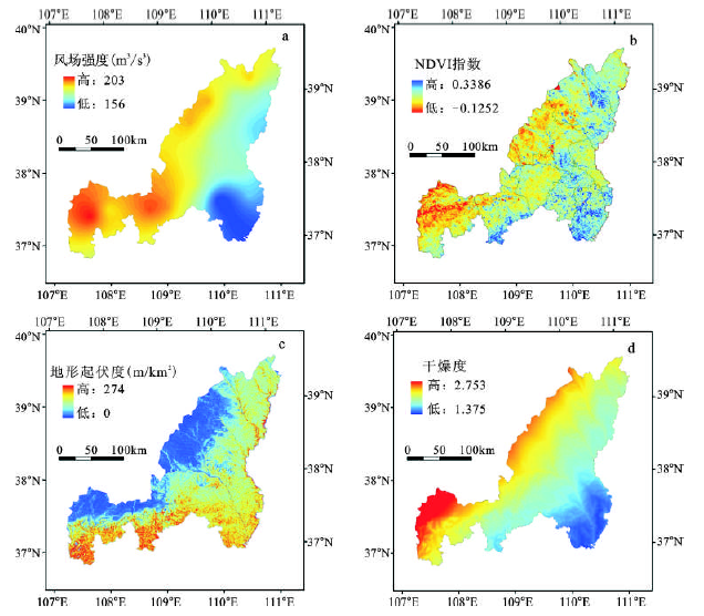
Fig.1 Spatial distribution of environmental elements on wind erosion in Yulin City图1 榆林市土壤风蚀环境因子分布 |
Fig.2 Spatial pattern of wind soil erosion risk in Yulin city(a) and the map of landform in Yulin City(b)图2 榆林市土壤风蚀危险度(a)和地形地貌分布(b) |
The authors have declared that no competing interests exist.
| [1] |
|
| [2] |
|
| [3] |
|
| [4] |
|
| [5] |
|
| [6] |
|
| [7] |
|
| [8] |
|
| [9] |
|
| [10] |
|
| [11] |
|
| [12] |
|
| [13] |
|
| [14] |
|
| [15] |
|
| [16] |
|
| [17] |
|
| [18] |
|
| [19] |
SL190-2007.土壤侵蚀分类分级标准[S].北京:中国水利水电出版社,2008.
|
| [19] |
|
| [20] |
|
| [21] |
|
| [22] |
|
| [23] |
|
/
| 〈 |
|
〉 |
