
南宋以来江苏海岸带历史海岸线时空演变研究
作者简介:张晓祥(1979-),男,江苏南通人,博士,副教授,主要从事空间分析与建模、资源环境遥感研究。E-mail: xiaoxiang@hhu.edu.cn
收稿日期: 2013-02-10
要求修回日期: 2013-06-03
网络出版日期: 2013-11-18
基金资助
国家科技支撑计划课题(2012BAC07B01、2012BAB03B01)、江苏近海海洋综合调查与评价项目(江苏908专项)资助
Historical Coastline Spatio-temporal Evolution Analysis in Jiangsu Coastal Area During the Past 1 000 Years
Received date: 2013-02-10
Request revised date: 2013-06-03
Online published: 2013-11-18
Copyright
张晓祥 , 王伟玮 , 严长清 , 晏王波 , 戴煜暄 , 徐盼 , 朱晨曦 . 南宋以来江苏海岸带历史海岸线时空演变研究[J]. 地理科学, 2014 , 34(3) : 344 -351 . DOI: 10.13249/j.cnki.sgs.2014.03.344
Historical coastline changes are very important in the coastal area study, which will benefit on utilization, development and protection of coastal areas. In this article, Jiangsu coastal areas are selected as the research area to perform a-1000-years' historical coastline evolution analysis from the South Song Dynasty in ancient China to recent years. Based on the historical coastline analysis, the underlying spatio-temporal evolution mechanism is explored. Firstly, Jiangsu coastal areas are divided into six subdivisions according to the physical geographical conditions and its historical geomorphologic changes. Secondly, Digital Shoreline Analysis System (DSAS) is used to build 356 effective coastline transacts and historical coastline changes are calculated for each transact. Thirdly, quantitative analysis and qualitative analysis are used to analyze the coastline spatio-temporal change in different historical periods. Finally, the driving forces of coastline historical change are revealed according to the above analysis. The study shows that the old Huanghe River changes severely and the maximum deposition rate and erosion rate reach 250 m/a, 600 m/a respectively. And the most important driving forces for the Millennium’s coastline changes are the historical events such as “The Huanghe River captured the Huaihe River” in 1128 AD and “The Huanghe River returned to the north” in 1855 AD and in modern times, as the major human activities, “Demolishing Salt-making Stoves and Cultivating Land” have more significant impact on the Jiangsu coastline change, resulting in the north and south radiate shoal changing obviously.
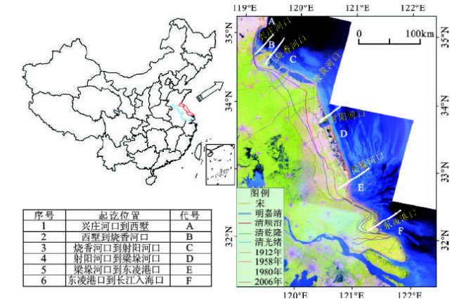
Fig.1 The location of study area图1 研究区区位 |
Table 1 Lists of the historical shoreline data and their sources表1 历史海岸线数据获取列表 |
| 序号 | 数据类型 | 年 代 | 比例尺/分辨率 | 主要数据来源 |
|---|---|---|---|---|
| 1 | 历史地图 历史地图 历史地图 历史地图 历史地图 | 南宋时期 | 1∶25万 | 中国海岸带和海图资源调查综合地图集(江苏省) |
| 2 | 明嘉靖时期 | 1∶25万 | 中国海岸带和海图资源调查综合地图集(江苏省) | |
| 3 | 清顺治时期 | 1∶25万 | 中国海岸带和海图资源调查综合地图集(江苏省) | |
| 4 | 清乾隆时期 | 1∶25万 | 中国海岸带和海图资源调查综合地图集(江苏省) | |
| 5 | 清光绪时期 | 1∶25万 | 中国海岸带和海图资源调查综合地图集(江苏省) | |
| 6 | 现代地形图 现代地形图 现代地形图 | 民国地形图 | 1∶5万 | 江苏省测绘地理信息局档案馆 |
| 7 | 1950年代 | 1∶5万 | 江苏省测绘地理信息局档案馆 | |
| 8 | 1980年代 | 1∶5万 | 江苏省测绘地理信息局档案馆 | |
| 9 | 遥感影像 | 2006年 | 30 m | 美国Landsat TM遥感卫星数据 |
Table 2 Lists of the used local chronicles and atlas表2 所用到的地方志、地图集资料列表 |
| 序号 | 出版物名称 | 编 者 | 出版年份(年) | 备注 |
|---|---|---|---|---|
| 1 | 江苏省志·地理志 | 江苏省地方志编纂委员会 | 1999 | 地方志 |
| 2 | 江苏省志·海涂开发志 | 江苏省地方志编纂编委会 | 1995 | 地方志 |
| 3 | 江苏省志·盐业志 | 江苏省地方志编纂委员会 | 1997 | 地方志 |
| 4 | 江苏省地图集 | 江苏省测绘局 | 2004 | 地图集 |
| 5 | 中国海岸带和海涂资源综合调查图集(江苏省) | 国家海洋局、国家测绘局 | 1988 | 地图集 |
| 6 | 江苏省海岛资源综合调查地图集 | 江苏省海岛资源综合调查地图集编纂委员会 | 1996 | 地图集 |
| 7 | 江苏省海岸带自然资源地图集 | 邓世杰 | 1988 | 地图集 |
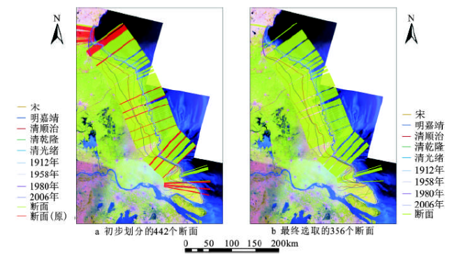
Fig.2 The coastline transacts图2 海岸线断面 |
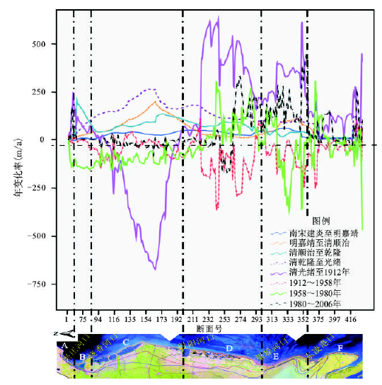
Fig.3 Coastline change rate in Jiangsu province during the past 1 000 years(m/a)图3 近1 000 a来江苏海岸带海岸线变化速率(m/a) |
Table 3 Qualitative analysis of historical coastline changes in Jiangsu coastal area表3 江苏海岸带历史海岸线演变的定性分析 |
| 分段 | 南宋至 明嘉靖 | 明嘉靖至 清顺治 | 清顺治至 清乾隆 | 清乾隆至 光绪 | 光绪至 1921年 | 1921~ 1958年 | 1958~ 1980年 | 1980~ 2006年 | 累计淤涨 情况 |
|---|---|---|---|---|---|---|---|---|---|
| A | 持平 | 持平 | 持平 | 淤涨 | 淤涨 | 侵蚀 | 侵蚀 | 淤涨 | 淤涨 |
| B | 持平 | 持平 | 淤涨 | 淤涨 | 淤涨 | 侵蚀 | 侵蚀 | 淤涨 | 淤涨 |
| C | 淤涨 | 淤涨 | 淤涨 | 淤涨 | 侵蚀 | 侵蚀 | 侵蚀 | 侵蚀 | 淤涨 |
| D | 淤涨 | 淤涨 | 淤涨 | 淤涨 | 侵蚀 | 侵蚀 | 淤涨 | 侵蚀 | 淤涨 |
| E | 淤涨 | 淤涨 | 淤涨 | 淤涨 | 淤涨 | 侵蚀 | 淤涨 | 淤涨 | 淤涨 |
| F | 持平 | 持平 | 淤涨 | 淤涨 | 淤涨 | 侵蚀 | 侵蚀 | 淤涨 | 淤涨 |
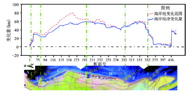
Fig.4 Coastline changes range and coastline net change amount in Jiangsu coastal areas(km)图4 江苏海岸带海岸线变化范围与海岸线净变化量(km) |
The authors have declared that no competing interests exist.
| [1] |
|
| [2] |
|
| [3] |
|
| [4] |
|
| [5] |
|
| [6] |
|
| [7] |
|
| [8] |
|
| [9] |
|
| [10] |
|
| [11] |
|
| [12] |
|
| [13] |
|
| [14] |
|
| [15] |
|
| [16] |
|
| [17] |
|
| [18] |
|
| [19] |
|
| [20] |
|
| [21] |
|
| [22] |
|
| [23] |
|
| [24] |
|
| [25] |
国家海洋局,国家测绘局.中国海岸带和海涂资源综合调查图集(江苏省分册)[M].北京:测绘出版社,1986.
|
| [26] |
江苏省地方志编纂委员会.江苏省志·地理志[M].江苏:江苏科学技术出版社,1999.
|
| [27] |
江苏省地方志编纂委员会.江苏省志·海涂开发志[M].南京:江苏科学技术出版社,1995.
|
| [28] |
江苏省地方志编纂委员会.江苏省志·盐业志[M].南京:江苏科学技术出版社,1997.
|
| [29] |
《江苏省地图集》编纂委员会.江苏省地图集[M].北京:中国地图出版社,2004.
|
| [30] |
|
| [31] |
|
| [32] |
江苏省海岛资源综合调查地图集编纂委员会.江苏省海岛资源综合调查地图集[M].北京:测绘出版社,1996.
|
| [33] |
|
| [34] |
|
| [35] |
|
| [36] |
|
/
| 〈 |
|
〉 |