
中原城市群城市空间联系网络格局分析——基于综合交通信息流
|
安俞静(1994-),女,河南周口人,博士研究生,主要从事人文地理学、城市发展与区域规划研究。E-mail: yujing_1912@163.com |
收稿日期: 2018-11-10
要求修回日期: 2019-04-17
网络出版日期: 2020-03-01
基金资助
国家自然科学基金项目资助(41701130)
版权
Urban Spatial Connection and Network Structure in Zhongyuan Urban Agglomeration: A Study Based on Integrated Traffic and Information Flow
Received date: 2018-11-10
Request revised date: 2019-04-17
Online published: 2020-03-01
Supported by
National Natural Science Foundation of China(41701130)
Copyright
安俞静 , 刘静玉 , 乔墩墩 . 中原城市群城市空间联系网络格局分析——基于综合交通信息流[J]. 地理科学, 2019 , 39(12) : 1929 -1937 . DOI: 10.13249/j.cnki.sgs.2019.12.011
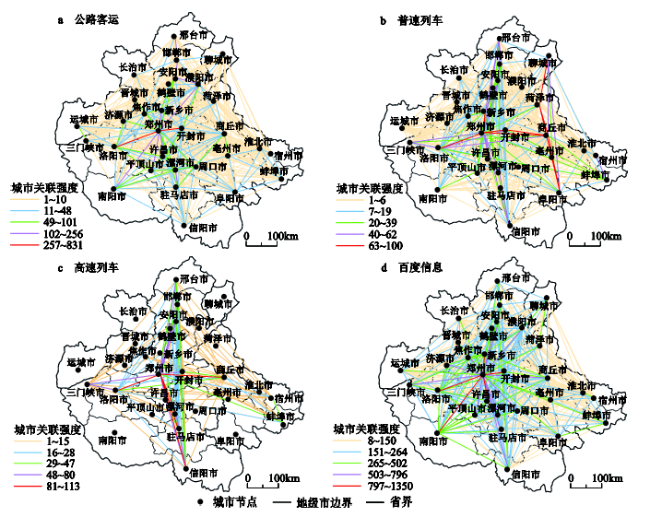
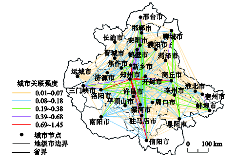
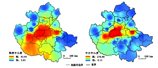
With the rapid development of globalization, informatization and urbanization, time-space compression has led to the considerable consolidation of linkages among cities, which show characteristics of network. Therefore, studies on urban network based on space flows have become one of the most important issues of human geography in the era of big date. This article focuses on the identification and spatial structure of multiple elementary flows as well as their synthesis effects for regional development. The data of space flows with highway buses, ordinary trains, high-speed trains and Baidu index information between provincial cities in Zhongyuan urban agglomeration are collected for analyses. Using hierarchy process, spatial variation and social network analytical methods, we explore characteristics of urban spatial connection and network structure from various aspects. Our results indicate that: 1) Traffic flows based urban network displays characteristics of the axis bands, cities with high value of external relations are distributed along the main traffic arteries, while Shanxi and Anhui are marginalized in the regional connection. In contrast, the information network shows a relatively complete, orderly, and coordinated state of connection, and generally presents a multi-dimensional diamone-shaped correlation pattern. The dominant flow is restricted by provincial boundaries and has obvious directivity, which is mostly the one-way flow from low-grade city to higher-grade city. 2) The comprehensive linkage network of traffic and information flow reflects a “one horizontal and two vertical” pattern with the basic characteristics of low density, single center and “rich club”. The connectivity ability among nodes varies significantly. Zhengzhou, Luoyang, Shangqiu and Anyang, in the core development area, have relatively stronger control over the connection network. 3) There is an outstanding phenomenon of subgroups agglomeration in this region, according to the comprehensive linkage network. Moreover, the urban distribution in each subgroup conforms to the principle of spatial proximity. “Axial and radial extension-grouped partition” is the main pattern of spatial organization in Zhongyuan urban agglomeration. 4) At last, the urban size, comprehensive development strength, infrastructure construction, administrative effects and policy orientation could explain the formation of urban spatial relationships and network structure.
表1 城市对间首位联系强度统计Table 1 Statistical results of dominant flow by city pair |
| 强联系 (0.6) (个) | 次强联系 (0.3~0.6) (个) | 弱联系 (<0.3) (个) | 耦合联系 (互为首位 联系)(个) | 平均首 位度 | |
|---|---|---|---|---|---|
| 公路 | 1 | 14 | 9 | 0 | 0.22 |
| 普速铁路 | 1 | 7 | 15 | 2 | 0.37 |
| 高速铁路 | 1 | 7 | 8 | 1 | 0.52 |
| 百度信息 | 2 | 10 | 14 | 1 | 0.26 |
表2 中原城市群综合联系网络凝聚子群密度Table 2 Density of cohesive subgroups of urban comprehensive network in Zhongyuan urban agglomeration |
| 1 | 2 | 3 | 4 | 5 | 6 | 7 | 8 | |
|---|---|---|---|---|---|---|---|---|
| 1 | 1.00 | 1.00 | 1.00 | 0.92 | 0.56 | 0.50 | 0.67 | 0.44 |
| 2 | 0.91 | 0.85 | 0.36 | 0.25 | 0.06 | 0.09 | 0.09 | 0.21 |
| 3 | 0.83 | 0.46 | 0.10 | 0.50 | 0.00 | 0.00 | 0.00 | 0.00 |
| 4 | 1.00 | 0.16 | 0.50 | 0.58 | 0.08 | 0.50 | 0.00 | 0.00 |
| 5 | 0.56 | 0.06 | 0.00 | 0.00 | 1.00 | 0.00 | 0.00 | 0.00 |
| 6 | 0.67 | 0.18 | 0.25 | 0.37 | 0.00 | 1.00 | 0.00 | 0.50 |
| 7 | 0.17 | 0.00 | 0.00 | 0.00 | 0.00 | 0.00 | 0.50 | 0.67 |
| 8 | 0.22 | 0.06 | 0.00 | 0.00 | 0.00 | 0.00 | 1.00 | 0.67 |
注: 1. 郑州-洛阳-新乡城市群; 2. 开封-商丘-焦作-许昌-周口-平顶山城市群; 3. 三门峡-济源城市群;4. 邯郸-邢台-安阳-鹤壁城市群; 5. 运城-长治-晋城城市群; 6. 聊城-菏泽城市群; 7. 蚌埠-淮北城市群; 8. 阜阳-宿州-亳州城市群 |
表3 中原城市群各城市可达性水平Table 3 Accessibility of cities in Zhongyuan urban agglomeration |
| 城市名称 | (h) | 城市名称 | (h) | 城市名称 | (h) | |||
|---|---|---|---|---|---|---|---|---|
| 郑州 | 2.70 | 0.58 | 鹤壁 | 4.42 | 0.94 | 晋城 | 5.04 | 1.08 |
| 开封 | 3.03 | 0.65 | 济源 | 4.50 | 0.97 | 濮阳 | 5.22 | 1.12 |
| 新乡 | 3.11 | 0.67 | 平顶山 | 4.53 | 0.98 | 聊城 | 5.53 | 1.19 |
| 许昌 | 3.26 | 0.70 | 菏泽 | 4.60 | 0.99 | 宿州 | 5.56 | 1.20 |
| 焦作 | 3.40 | 0.73 | 周口 | 4.64 | 0.99 | 阜阳 | 5.62 | 1.21 |
| 安阳 | 3.60 | 0.77 | 邢台 | 4.65 | 1.00 | 南阳 | 5.69 | 1.22 |
| 洛阳 | 3.69 | 0.79 | 驻马店 | 4.67 | 1.01 | 淮北 | 5.86 | 1.26 |
| 漯河 | 3.91 | 0.84 | 三门峡 | 4.95 | 1.06 | 长治 | 6.17 | 1.33 |
| 商丘 | 4.00 | 0.86 | 信阳 | 5.01 | 1.08 | 蚌埠 | 6.61 | 1.42 |
| 邯郸 | 4.06 | 0.87 | 亳州 | 5.02 | 1.08 | 运城 | 6.91 | 1.49 |
注: Ai为i城市的综合交通可达性水平; Ai' 为i城市的可达性系数。 |
| [1] |
王姣娥, 景悦 . 中国城市网络等级结构特征及组织模式——基于铁路和航空流的比较[J]. 地理学报, 2017,72(8):1508-1519.
[
|
| [2] |
陈伟, 刘卫东, 柯文前 , 等. 基于公路客流的中国城市网络结构与空间组织模式[J]. 地理学报, 2017,72(2):224-241.
[
|
| [3] |
|
| [4] |
|
| [5] |
|
| [6] |
王茂军, 柴箐 . 北京市产业网络结构特征与调节效应[J]. 地理研究, 2013,32(3):543-555.
[
|
| [7] |
庄德林, 杨羊, 晋盛武 , 等. 基于战略性新兴产业的长江三角洲城市网络结构演变研究[J]. 地理科学, 2017,37(4):546-553.
[
|
| [8] |
盛科荣, 张红霞, 佀丹丹 . 中国城市网络中心性的空间格局及影响因素[J]. 地理科学, 2018,38(8):1256-1265.
[
|
| [9] |
季菲菲, 陈雯, 魏也华 , 等. 长三角一体化下的金融流动格局变动及驱动机理——基于上市企业金融交易数据的分析[J]. 地理学报, 2014,69(6):823-837.
[
|
| [10] |
|
| [11] |
|
| [12] |
金凤君, 王成金 . 轴-辐侍服理念下的中国航空网络模式构筑[J]. 地理研究, 2005,24(5):774-784.
[
|
| [13] |
王海江, 苗长虹 . 中国航空联系的网络结构与区域差异[J]. 地理科学, 2015,35(10):1220-1229.
[
|
| [14] |
冯兴华, 修春亮, 刘志敏 , 等. 东北地区城市网络层级演变特征分析——基于铁路客运流视角[J]. 地理科学, 2018,38(9):1430-1438.
[
|
| [15] |
高鑫, 修春亮, 魏冶 . 基于高速公路货流数据的重庆市区县关联网络格局研究[J]. 人文地理, 2016,31(1):73-80.
[
|
| [16] |
王姣娥, 焦敬娟, 金凤君 . 高速铁路对中国城市空间相互作用强度的影响[J]. 地理学报, 2014,69(12):1833-1846.
[
|
| [17] |
孙阳, 姚士谋, 张落成 . 中国沿海三大城市群城市空间网络拓展分析——以综合交通信息网络为例[J]. 地理科学, 2018,38(6):827-837.
[
|
| [18] |
叶磊, 段学军, 欧向军 . 基于交通信息流的江苏省流空间网络结构研究[J]. 地理科学, 2015,35(10):1230-1237.
[
|
| [19] |
陈伟, 修春亮, 柯文前 , 等. 多元交通流视角下的中国城市网络层级特征[J]. 地理研究, 2015,34(11):2073-2083.
[
|
| [20] |
甄峰, 王波, 陈映雪 . 基于网络社会空间的中国城市网络特征——以新浪微博为例[J]. 地理学报, 2012,67(8):1031-1043.
[
|
| [21] |
黎智枫, 赵渺希 . 赛博空间视角下中国三大城市群网络特征——基于豆瓣跨城活动数据[J]. 人文地理, 2016,31(6):102-107.
[
|
| [22] |
邓楚雄, 宋雄伟, 谢炳庚 , 等. 基于百度贴吧数据的长江中游城市群城市网络联系分析[J]. 地理研究, 2018,37(6):1181-1192.
[
|
| [23] |
王垚, 钮心毅, 宋小冬 , 等. 人流联系和经济联系视角下区域城市关联比较——基于手机信令数据和企业关联数据的研究[J]. 人文地理, 2018,33(2):84-91.
[
|
| [24] |
王波, 甄峰, 张浩 . 基于签到数据的城市活动时空间动态变化及区划研究[J]. 地理科学, 2015,35(2):151-160.
[
|
| [25] |
|
| [26] |
魏冶, 修春亮, 刘志敏 , 等. 春运人口流动透视的转型期中国城市网络结构[J]. 地理科学, 2016,36(11):1654-1660.
[
|
| [27] |
李丹丹, 汪涛, 魏也华 , 等. 中国城市尺度科学知识网络与技术知识网络结构的时空复杂性[J]. 地理研究, 2015,34(3):525-540.
[
|
| [28] |
马海涛 . 基于人才流动的城市网络关系构建[J]. 地理研究, 2017,36(1):161-170.
[
|
| [29] |
国家统计局城市社会经济调查司. 中国城市统计年鉴[M]. 北京: 中国统计出版社, 2017.
[ National Bureau of Statistics the city Social and Economic Investigation Department. China city statistical yearbook. Beijing: China Statistics Press, 2017.]
|
| [30] |
刘军 . 整体网分析讲义:UCINET软件实用指南[M]. 上海: 上海人民出版社, 2009.
[
|
| [31] |
何胜, 唐承丽, 周国华 . 长江中游城市群空间相互作用研究[J]. 经济地理, 2014,34(4):46-53.
[
|
| [32] |
王姣娥, 金凤君, 孙炜 , 等. 中国机场体系的空间格局及其服务水平[J]. 地理学报, 2006,61(8):829-838.
[
|
| [33] |
孟德友, 冯兴华, 文玉钊 . 铁路客运视角下东北地区城市网络结构演变及组织模式探讨[J]. 地理研究, 2017,36(7):1339-1352.
[
|
/
| 〈 |
|
〉 |