
中国铁路客运流联结的城市时间可达性
|
张莉(1977-),女,河北正定人,副教授,博士,主要从事经济地理与区域规划研究。E-mail: zhangli@njnu.edu.cn |
收稿日期: 2019-04-21
要求修回日期: 2019-08-31
网络出版日期: 2020-05-13
基金资助
国家自然科学基金项目资助(41571120)
国家自然科学基金项目资助(41430635)
版权
Urban Time Accessibility of Railway Passenger Traffic Flow in China
Received date: 2019-04-21
Request revised date: 2019-08-31
Online published: 2020-05-13
Supported by
National Natural Science Foundation of China(41571120)
National Natural Science Foundation of China(41430635)
Copyright
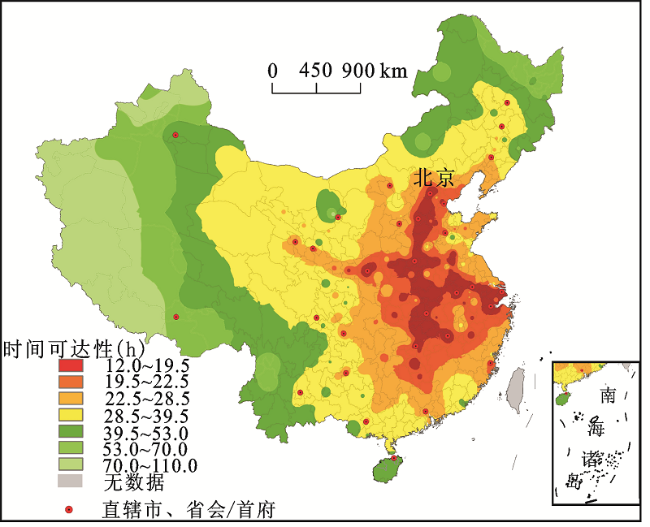
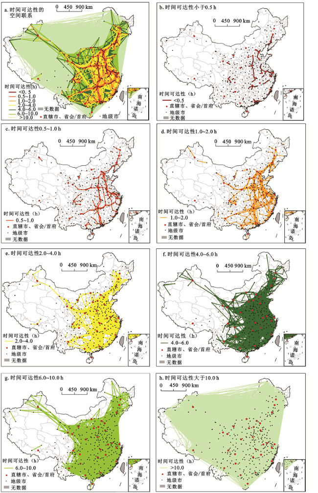
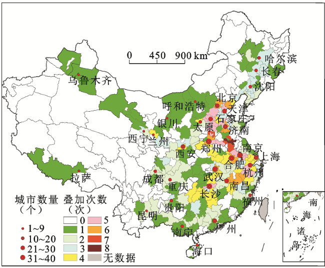
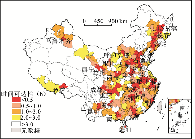
基于中国铁路客户服务中心提供的客运流数据,采集全国地级以上行政单元(未含港澳台数据)间铁路客运运行的最短历时,基于GIS网络分析和空间分析等方法,选取时间可达性和一日交流圈2个指标对城市可达性进行测度和分析。研究发现: ① 城市时间可达性水平划分为7个级别,在空间上呈现中心-外围式圈层结构,中心区域沿铁路干线和高速铁路线轴向扩展,廊道效应明显,东部、中部地区的城市时间可达性优于西部地区。② 城市之间的时间可达性小于2.0 h的城市对在空间上构成了由京广、京沪、京哈、京福、杭深、青太、徐兰、沪汉蓉、沪昆、广昆等高速铁路连接的“五纵五横”带状分布格局。时间可达性小于10.0 h的城市对覆盖了“胡焕庸线”东南部的大部分区域,城市带转为城市网络。③ 直辖市、省会/首府城市一日交流圈以31个城市为中心,按照时间可达性由小到大呈现轴向扩展,廊道效应明显。基于城市一日交流圈划分了19个城市群和拉萨城市圈,为城市群的划分提供方法借鉴。
张莉 , 赵英杰 , 陆玉麒 , 滕野 . 中国铁路客运流联结的城市时间可达性[J]. 地理科学, 2020 , 40(3) : 354 -363 . DOI: 10.13249/j.cnki.sgs.2020.03.003
Within region, accessibility refers to the degree of convenience which a particular transportation system can be used to reach other cities or regions. Railway passenger transport is an important part of China's long-distance passenger transport system. The opening and operation of the high-speed railway has shortened the travel time between cities along the line, and has a profound impact on regional spatial organization. Temporal distance has been widely applied to the evaluation of railway accessibility. Based on the railway passenger transport flow, this paper captures the shortest time between 315 cities in China (excluding Hong Kong, Macau and Taiwan) by using the network data of www.12306.cn. And this paper explores the spatial pattern of urban time accessibility and the spatial connections and hierarchical characteristics of the inter-city time accessibility through the network analysis and the spatial analysis of GIS. According to the result of time accessibility, it analyzes the isochronous rings and daily-communication-area of 31 central cities. The research indicates: 1) At present, China has 315 prefecture-level administrative units with railway passenger train stops. According to the natural discontinuity classification method, the time accessibility level is categorized into seven degrees,present a core-periphery sphere structure. The central area extends axially along the main railway line and high-speed railway line, which shows the strong influence of the ‘corridor’. The urban time accessibility of the eastern and central regions is better than the western region. 2) The city pairs with time accessibility less than 2 hours constitute a ‘Five vertical and five horizontal’ zonation pattern connected by Beijing-Guangzhou HSR, Beijing-Shanghai HSR, Beijing-Harbin HSR, Beijing-Fuzhou HSR, Hangzhou-Shenzhen HSR, Qingdao-Taiyuan HSR, Xuzhou-Lanzhou HSR, Shanghai-Wuhan-Chengdu HSR, Shanghai-Kunming HSR and Guangzhou-Kunming HSR lines. Cities with time accessibility less than 10 hours cover most of the southeast region of the ‘Hu Huanyong Line’ and the urban belt is transformed into the urban network. Cities with time accessibility longer than 10 hours are mainly connected to the eastern and western regions with a long spatial distance. 3) Daily-communication-area of central cities expand axially. And the corridor effect is obvious. It is divided into four degrees according to the number of cities included in the daily-communication-area. The daily-communication-area covers 227 cities which mainly distribute in the southeast of the ‘Hu Huanyong Line’. This paper divides 19 urban agglomerations and Lhasa city circle based on the daily-communication-area of 31 cities. Compared with the urban agglomeration development plan approved by the State Council, the scope of the urban agglomeration is highly consistent, which provides a reference for the division of urban agglomerations.
图2 中国城市城际时间可达性的空间联系与层级结构未含港澳台数据 Fig.2 Spatial relation and hierarchical structure of time accessibility between cities in China |
表1 中国时间可达性小于2.0 h的直辖市、省会/首府城市对(h)Table 1 Pairs of cities which time accessibility is less than 2 hours in China (h) |
| 城市对 | 时间 可达性 | 城市对 | 时间 可达性 | 城市对 | 时间 可达性 | 城市对 | 时间 可达性 | 城市对 | 时间 可达性 | 城市对 | 时间 可达性 |
|---|---|---|---|---|---|---|---|---|---|---|---|
| 北京-天津 | 0.5 | 南京-合肥 | 1.0 | 南京-杭州 | 1.1 | 石家庄-郑州 | 1.4 | 重庆-成都 | 1.5 | 重庆-成都 | 2.0 |
| 上海-杭州 | 0.8 | 上海-南京 | 1.0 | 兰州-西宁 | 1.2 | 北京-济南 | 1.4 | 郑州-武汉 | 1.7 | 贵阳-昆明 | 2.0 |
| 长春-哈尔滨 | 0.9 | 沈阳-长春 | 1.1 | 武汉-长沙 | 1.3 | 石家庄-太原 | 1.4 | 郑州-西安 | 1.8 | 合肥-武汉 | 2.0 |
| 天津-济南 | 1.0 | 北京-石家庄 | 1.1 | 南昌-长沙 | 1.4 | 天津-石家庄 | 1.5 | 南昌-武汉 | 1.9 | 沈阳-哈尔滨 | 2.0 |
注:不含港澳台数据。 |
图4 中国直辖市、省会/首府城市不重叠的一日交流圈未含港澳台数据 Fig.4 Nonoverlapping daily-communication-areas of municipalities and provincial capital cities in China |
表2 中国直辖市和省会/首府城市不重叠的一日交流圈及城市群划分Table 2 The range of nonoverlapping daily-communication-areas of cities and division of urban agglomerations in China |
| 城市群/ 城市圈 | 直辖市省 会/首府 | 0~0.5 h 包含城市 | 0.5~1.0 h 包含城市 | 1.0~2.0 h 包含城市 | 2.0~3.0 h 包含城市 | 城市数 之比 |
|---|---|---|---|---|---|---|
| 哈长 城市群 | 哈尔滨(3) | 大庆(2) | 齐齐哈尔(1)、绥化(1) | 3.00 | ||
| 长春(3) | 四平(3) | 吉林(3) | 辽源(1)、松原(1) | 延边州(1)、 白城(1) | 2.86 | |
| 辽中南 城市群 | 沈阳(3) | 鞍山(3)、本溪(3)、 辽阳(3)、铁岭(3) | 营口(2)、抚顺(1) | 锦州(3)、葫芦岛(3)、 大连(2)、丹东(2)、 盘锦(2)、阜新(1) | 1.46 | |
| 长江三角洲 城市群 | 南京(8) | 镇江(5)、滁州(5)、 马鞍山(3) | 蚌埠(7)、宿州(7)、常州(5)、 芜湖(3)、扬州(2) | 泰州(2) | 南通(1)、盐 城(1) | 3.25 |
| 上海(4) | 无锡(4)、苏州(4) | 9.00 | ||||
| 杭州(5) | 绍兴(4)、湖州(4)、 嘉兴(4) | 金华(5)、宁波(3) | 衢州(6)、丽水(4)、台州(3) | 宣城(3) | 2.80 | |
| 合肥(6) | 淮南(4)、六安(4) | 铜陵(2) | 黄山(4)、池州(2)、安庆(2) | 阜阳(1) | 4.13 | |
| 长江中游 城市群 | 武汉(6) | 咸宁(4)、鄂州(4)、 孝感(3)、黄冈(2) | 黄石(4)、信阳(4) | 荆州(1)、宜昌(1)、随州(1) | 襄阳(1) | 3.27 |
| 长沙(5) | 株洲(4)、湘潭(3)、 萍乡(2) | 衡阳(4)、岳阳(4)、娄底(4)、 邵阳(4)、益阳(1) | 怀化(4)、郴州(4)、 永州(1)、常德(1) | 2.69 | ||
| 南昌(6) | 鹰潭(6)、上饶(6)、抚州(4)、 九江(2)、新余(2)、宜春(2) | 吉安(1) | 3.63 | |||
| 成渝 城市群 | 重庆(2) | 内江(2) | 南充(2)、广安(2) | 达州(2)、恩 施州(1) | 1.83 | |
| 成都(2) | 德阳(2)、资阳(2) | 遂宁(2)、绵阳(1)、乐山(1)、 眉山(1) | 广元(3) | 1.75 | ||
| 珠江三角洲 城市群 | 广州(2) | 深圳(2)、清远(2)、佛山 (1)、东莞(1)、中山(1) | 韶关(2)、肇庆(2)、云浮(2)、 江门(1)、珠海(1) | 梧州(2)、惠州(1)、 汕尾(1)、贺州(1) | 河源(1) | 1.38 |
| 海峡西岸 城市群 | 福州(2) | 莆田(1) | 南平(3)、泉州(1)、宁德(1) | 三明(2)、温州(2)、 厦门(1)、漳州(1) | 龙岩(1) | 1.90 |
| 黔中城市群 | 贵阳(3) | 安顺(2) | 黔东南州(2)、黔南州(1) | 遵义(1) | 2.40 | |
| 滇中城市群 | 昆明(2) | 曲靖(2)、玉溪(2) | 楚雄州(1)、文山州(1) | 1.80 | ||
| 北部湾 城市群 | 南宁(1) | 贵港(2)、钦州(1)、来宾(1) | 百色(2)、北海(1)、玉林(1)、 防城港(1)、柳州(1) | 桂林(3)、崇 左(1) | 1.27 | |
| 海口(1) | 儋州(1) | 三亚(1) | 1.33 | |||
| 京津冀 城市群 | 北京(6) | 张家口(1) | 12.00 | |||
| 天津(5) | 唐山(6)、沧州(3)、廊 坊(3) | 秦皇岛(4) | 5.20 | |||
| 石家庄(5) | 邢台(5) | 邯郸(5)、保定(5) | 衡水(4) | 4.40 | ||
| 山东半岛城市群 | 济南(6) | 泰安(6)、德州(5) | 徐州(8)、枣庄(7)、淄博(3) | 潍坊(2)、聊城(1) | 青岛(1)、济 宁(1) | 2.70 |
| 呼包鄂榆城市群 | 呼和浩特(1) | 乌兰察布(1) | 包头(1) | 鄂尔多斯(1) | 1.00 | |
| 山西中部城市群 | 太原(4) | 晋中(2) | 阳泉(5) | 临汾(2)、忻州(1)、吕梁(1) | 大同(1) | 2.29 |
| 关中平原城市群 | 西安(4) | 咸阳(3)、渭南(3) | 宝鸡(2) | 运城(2)、汉中(2) | 商洛(1)、安 康(1)、延安(1) | 2.67 |
| 中原城市群 | 郑州(6) | 新乡(6)、开封(5)、许 昌(4) | 安阳(7)、鹤壁(5)、商丘(5)、 漯河(5)、洛阳(4)、驻马店(4)、 三门峡(2)、焦作(1) | 3.08 | ||
| 兰州-西宁 城市群 | 兰州(4) | 定西(3) | 天水(3)、白银(1) | 2.25 | ||
| 西宁(3) | 海东(2) | 海北州(1) | 张掖(1) | 酒泉(1) | 1.60 | |
| 宁夏沿黄城市群 | 银川(1) | 石嘴山(1)、吴忠(1) | 乌海(1) | 中卫(1) | 1.00 | |
| 天山北坡城市群 | 乌鲁木齐(1) | 吐鲁番(1) | 塔城地区(1)、昌吉州(1) | 1.00 | ||
| 拉萨城市圈 | 拉萨(1) | 日喀则(1) | 1.00 |
注:城市名后括号内的数字表示该城市的叠加次数。城市数之比为城市重叠的一日交流圈与不重叠的一日交流圈包含城市数之比。 |
| [1] |
|
| [2] |
李平华, 陆玉麒 . 可达性研究的回顾与展望[J]. 地理科学进展, 2005,24(3):69-78.
[
|
| [3] |
|
| [4] |
OmerI. Evaluating accessibility using house-level data: A spatial equity perspective[J]. Computers,Environment and Urban Systems, 2006,30(6):254-274.
|
| [5] |
|
| [6] |
|
| [7] |
|
| [8] |
尹海伟, 孔繁花 . 济南市城市绿地可达性分析[J]. 植物生态学报, 2006,30(1):17-24.
[
|
| [9] |
姜博, 初楠臣, 修春亮 , 等. 中国“四纵四横”高铁网络可达性综合评估与对比[J]. 地理学报, 2016,71(4):591-604.
[
|
| [10] |
王姣娥, 焦敬娟, 金凤君 . 高速铁路对中国城市空间相互作用强度的影响[J]. 地理学报, 2014,69(12):1833-1846.
[
|
| [11] |
吴威, 曹有挥, 梁双波 . 20世纪80年代以来长三角地区综合交通可达性的时空演化[J]. 地理科学进展, 2010,29(5):619-626.
[
|
| [12] |
冯长春, 丰学兵, 刘思君 . 高速铁路对中国省际可达性的影响[J]. 地理科学进展, 2013,32(8):1187-1194.
[
|
| [13] |
王祖静 . 基于客运交通数据的城市体系和内部空间相互作用及变化研究[D]. 上海:华东师范大学, 2017.
[
|
| [14] |
吴威, 曹有挥, 梁双波 , 等. 中国铁路客运网络可达性空间格局[J]. 地理研究, 2009,28(5):1389-1400.
[
|
| [15] |
金凤君, 王姣娥, 孙炜 , 等. 铁路客运提速的空间经济效果评价[J]. 铁道学报, 2003,25(6):1-7.
[
|
| [16] |
钟业喜, 黄洁, 文玉钊 . 高铁对中国城市可达性格局的影响分析[J]. 地理科学, 2015,35(4):387-395.
[
|
| [17] |
孟德友, 陈文峰, 陆玉麒 . 高速铁路建设对我国省际可达性空间格局的影响[J]. 地域研究与开发, 2011,30(4):6-10.
[
|
| [18] |
姜博, 初楠臣, 修春亮 , 等. 高速铁路对欠发达地区可达性影响的空间差异——以哈大与郑西高铁为例[J]. 人文地理, 2017,32(2):88-94.
[
|
| [19] |
张萌萌, 孟晓晨 . 高速铁路对中国城市市场潜力的影响——基于铁路客运可达性的分析[J]. 地理科学进展, 2014,33(12):1650-1658.
[
|
| [20] |
黄洁, 钟业喜 . 长江中游城市群铁路客运联系及其空间格局演变[J]. 世界地理研究, 2016,25(2):72-81.
[
|
| [21] |
钟业喜, 傅钰, 冯兴华 . 基于铁路客运的中国城市可达性及类型研究[J]. 长江流域资源与环境, 2016,25(11):1645-1653.
[
|
| [22] |
王海江, 苗长虹 . 基于O-D网络的全国中心城市铁路客运联系及其分布规律[J]. 经济地理, 2014,34(5):83-90.
[
|
| [23] |
王海江, 苗长虹 . 中国中心城市铁路客运的空间联系及其结构图谱[J]. 地理研究, 2015,34(1):157-168.
[
|
| [24] |
陈伟, 修春亮, 柯文前 , 等. 多元交通流视角下的中国城市网络层级特征[J]. 地理研究, 2015,34(11):2073-2083.
[
|
| [25] |
罗震东, 何鹤鸣, 耿磊 . 基于客运交通流的长江三角洲功能多中心结构研究[J]. 城市规划学刊, 2011(2):16-23.
[
|
| [26] |
王德, 郭玖玖 . 北京市一日交流圈的空间特征及其动态变化研究[J]. 现代城市研究, 2008(5):68-75.
[
|
/
| 〈 |
|
〉 |