
汾河流域城乡聚落体系发展潜能测度及空间模式探究
|
侯志华(1981−),女,山西阳泉人,副教授,主要从事遥感与GIS在资源环境与城乡规划方面应用研究。E-mail: houzhihua1008@126.com |
收稿日期: 2019-07-29
修回日期: 2020-02-04
网络出版日期: 2021-01-09
版权
Development Potential and Spatial Pattern of Urban-rural Settlement System in the Fenhe River Basin
Received date: 2019-07-29
Revised date: 2020-02-04
Online published: 2021-01-09
Copyright
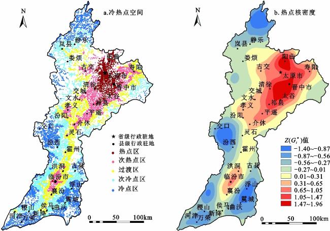
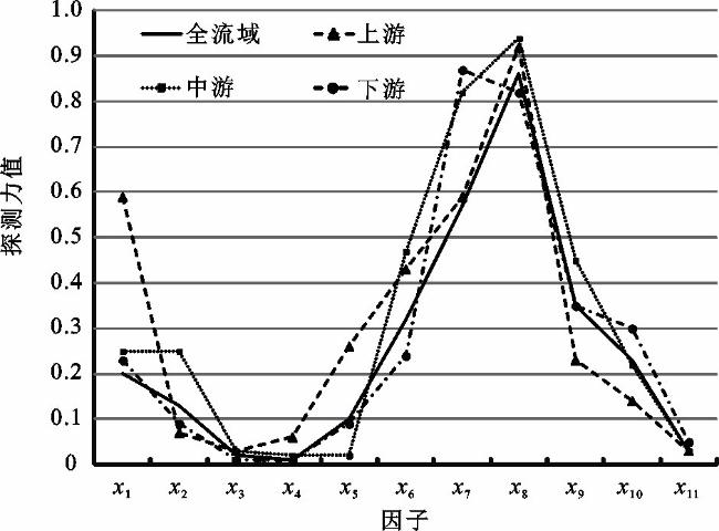
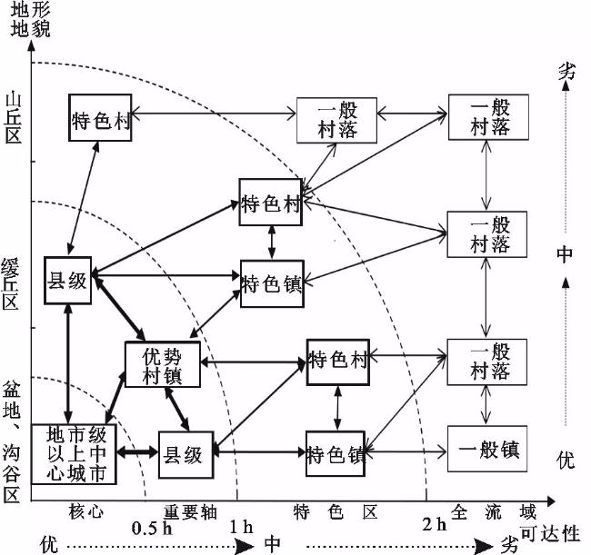
以11 188个自然聚落斑块为研究对象,基于场强模型,定量测度汾河流域城乡聚落体系发展潜能,借助GIS技术和地理探测器模型,分析其空间格局特征及驱动因素,进而探讨流域城乡融合发展空间模式。结果表明:① 城乡聚落斑块发展潜能差异显著,且空间分布极不均衡;纵向上中游流域高于下游流域高于上游流域,横向上河谷盆地区高于周边缓丘区高于两侧山丘区。② 聚落斑块发展潜能具有正向空间自相关性,高值斑块聚类显著;具有空间异质性特征且方向性明显,汾河主河道方向联动效应最强,空间联系最紧密;存在局域热点区,并呈现“主核–廊道–次核”的空间结构形态。③ 自然基础、社会经济发展水平和区位条件共同影响着城乡聚落体系发展潜质及空间结构形态;融合发展采取非均衡增长路径,市、县、镇、村全局考虑,构建“强化核心点–培育发展轴–扶持特色区–带动全流域”的逐层推进式空间发展模式。
侯志华 , 刘敏 , 樊晓霞 , 贾宇平 . 汾河流域城乡聚落体系发展潜能测度及空间模式探究[J]. 地理科学, 2020 , 40(12) : 1978 -1989 . DOI: 10.13249/j.cnki.sgs.2020.12.004
The article used field model to calculate development potential of urban-rural system choosing 11, 188 settlement patches as study object, analyzed the spatial characters by GIS technology and explored factors based on Geodetector model, lastly, discussed the spatial pattern of the urban-rural integration. Several conclusions can be drawn as follows: 1) The development potential has significant difference and its distribution was unbalanced. From a vertical perspective, the average value of potential was the highest in the middle reaches, the second in the lower reaches and the lowest in upper reaches. From the crosswise view, it was occupied first place in basin, come second in hilly area and was third in mountain. 2) The potential of settlements overall positive spatial autocorrelation and showed a significant pattern of high-high spatial clustering. The potential has distinct spatial heterogeneity and was different in the each direction. The spatial interaction is the strongest in those settlements among the main direction of the Fenhe River. By hot spot analysis, it was found that the hot spots and hot sub-spots were intensively distributed with the spatial structure of “main core-corridor-sub core”. 3) Natural conditions, social and economic development level and distance to the center cities are the three main factors influencing the development potential and spatial structure of urban-rural settlement system. Non-balanced development is necessary, and “Point-Axis-Net-Area” development mode was build. Specifically, in the beginning, we should focus on building the core region, then set up the main development axis. The key remaining step is putting priority on the development of distinctive settlements which processes some kind of energy level and radiometric force. Finally, all settlements in urban-rural system support and promote each other and ultimately achieve integrated development.
1 Speed and time cost for main means of transportation主要交通方式行车速度和时间成本设定 |
| 交通类型 | 速度/(km/h) | 时间成本/(min/km) |
| 高速铁路 | 200 | 0.30 |
| 普通铁路 | 100 | 0.50 |
| 高速公路 | 120 | 0.60 |
| 国道 | 80 | 0.75 |
| 省道 | 60 | 1.00 |
| 县道 | 40 | 1.50 |
| 乡道 | 20 | 3.00 |
| 陆地 | 5 | 12.00 |
表2 2019年汾河流域城乡聚落规模体系统计特征Table 2 The statistical features of the urban-rural scale system in typical regions of the Fenhe River Basin in 2019 |
| 子流域 | 聚落个数/个 | 聚落总规模/km2 | 聚落平均规模/km2 | 地貌类型 | 聚落个数/个 | 聚落总规模/km2 | 聚落平均规模/km2 | |
| 上游区 | 1841 | 166.90 | 0.09 | 盆地、沟谷区 | 6074 | 2723.32 | 0.45 | |
| 县级 | 17 | 43.16 | 2.54 | 省会城市级 | 12 | 459.46 | 38.29 | |
| 镇级 | 14 | 13.64 | 0.97 | 地市级 | 5 | 167.20 | 33.44 | |
| 乡村级 | 1810 | 110.10 | 0.06 | 县级 | 51 | 444.36 | 8.71 | |
| 中游区 | 5228 | 1860.30 | 0.36 | 镇级 | 167 | 383.15 | 2.29 | |
| 省会城市级 | 14 | 463.59 | 33.11 | 乡村级 | 5839 | 1269.15 | 0.22 | |
| 地市级 | 3 | 93.80 | 31.27 | 丘陵区 | 4561 | 349.40 | 0.08 | |
| 县级 | 26 | 265.63 | 10.22 | 省会城市级 | 2 | 4.13 | 2.07 | |
| 镇级 | 89 | 245.76 | 2.76 | 县级 | 11 | 29.96 | 2.72 | |
| 乡村级 | 5096 | 791.53 | 0.16 | 镇级 | 26 | 20.64 | 0.79 | |
| 下游区 | 4119 | 1058.81 | 0.26 | 乡村级 | 4522 | 294.67 | 0.07 | |
| 地市级 | 2 | 73.40 | 36.70 | 山地区 | 553 | 13.29 | 0.02 | |
| 县级 | 19 | 165.53 | 8.71 | 乡村级 | 553 | 13.29 | 0.02 | |
| 镇级 | 90 | 144.40 | 1.60 | 总计 | 11188 | 3086.01 | 0.28 | |
| 乡村级 | 4008 | 675.47 | 0.17 | |||||
| 总计 | 11188 | 3086.01 | 0.28 |
表3 汾河子流域城乡聚落体系平均发展潜能统计Table 3 The average value of potential of the urban-rural system in sub-basin scale in the Fenhe River Basin |
| 上游流域 | 中游流域 | 下游流域 | |
| 注:“–”表示该子流域中无此类型城乡聚落。 | |||
| 总平均值 | 71.61 | 133.06 | 75.29 |
| 省会城市级 | – | 524.42 | – |
| 地市级 | – | 414.85 | 246.10 |
| 县级 | 118.20 | 188.67 | 104.13 |
| 镇级 | 104.90 | 162.03 | 92.14 |
| 乡村级 | 70.91 | 131.03 | 74.69 |
表4 地理探测器的变量和指标说明Table 4 Description of variables and measures of Geodetector |
| 影响因子 | 数据获得途径 | 单位 | 分级 |
| x1高程 | DEM | m | 10 |
| x2坡度 | DEM栅格表面分析 | (º) | 10 |
| x3坡向 | DEM栅格表面分析 | (º) | 8 |
| x4距河流距离 | 欧式距离分析 | km | 6 |
| x5斑块面积 | 软件自动统计 | km2 | 10 |
| x6到县级中心城市可达性 | 时间成本距离 | min | 10 |
| x7到市级中心城市可达性 | 时间成本距离 | min | 10 |
| x8到省级中心城市可达性 | 时间成本距离 | min | 10 |
| x9人口密度 | 统计年鉴乡镇级人口密度的克里金插值估计 | 人/km2 | 10 |
| x10GDP | 灯光影像反演 | 10 | |
| x11距煤矿距离 | 欧式距离分析 | km | 10 |
表5 汾河流域不同区位城乡聚落体系平均发展潜能统计Table 5 The average value of potential of the urban-rural system in different location in the Fenhe River Basin |
| 省会城市级 | 地市级 | 县级 | 镇级 | 乡村级 | |
| 注:空白无此项。 | |||||
| 盆地、沟谷区 | |||||
| 1 h圈 | 565.91 | 347.35 | 151.61 | 140.91 | 129.91 |
| 1~2 h圈 | 70.38 | 73.90 | |||
| 2 h以上 | 51.67 | 57.43 | |||
| 缓丘区 | |||||
| 1 h圈 | 275.52 | 115.54 | 85.21 | 81.88 | |
| 1~2 h圈 | 77.90 | 70.09 | |||
| 2 h以上 | 56.40 | ||||
| 山丘区 | |||||
| 1 h圈 | 97.04 | ||||
| 1~2 h圈 | 53.95 | ||||
| 2 h以上 | 48.78 | ||||
| [1] |
李智, 张小林, 李红波. 县域城乡聚落规模体系的演化特征及驱动机理——以江苏省张家港市为例[J]. 自然资源学报, 2019, 34 (1): 140-152.
Li Zhi, Zhang Xiaolin, Li Hongbo. Evolution characteristics and driving mechanism of urban-rural scale system at county level: A case of Zhangjiagang City, Jiangsu Province[J]. Journal of Natural Resources, 2019, 34 (1): 140-152.
|
| [2] |
刘彦随. 中国新时代城乡融合与乡村振兴[J]. 地理学报, 2018, 73 (4): 637-650.
Liu Yansui. Research on the urban-rural integration andrural revitalization in the new era in China[J]. Acta Geographica Sinica, 2018, 73 (4): 637-650.
|
| [3] |
周一星, 杨齐. 我国城镇等级体系变动的回顾及其省区地域类型[J]. 地理学报, 1986, 41 (2): 97-111.
Zhou Yixing, Yang Qi. A review on the urban-size hierarchy of China and the territorial types of the hierarchy on provincial level[J]. Acta Geographica Sinica, 1986, 41 (2): 97-111.
|
| [4] |
陈彦光, 周一星. 豫北地区城镇体系空间结构的多分形研究[J]. 北京大学学报(自然科学版), 2001, 37 (6): 810-818.
Chen Yanguang, Zhou Yixing. A study of multifractional measures of the spatial structure of the urban system in Central Plains[J]. Acta Scientiarum Naturalium Universitatis Pekinensis, 2001, 37 (6): 810-818.
|
| [5] |
朱玲玲, 郭志富, 张竟竟, 等. 河南省城镇体系空间优化研究[J]. 地域研究与开发, 2017, 36 (3): 78-81+98.
Zhu Lingling, Guo Zhifu, Zhang Jingjing et al. Study on urban spatial structure optimization in Henan Province[J]. Areal Research and Development, 2017, 36 (3): 78-81+98.
|
| [6] |
肖磊, 黄金川, 孙贵艳. 京津冀都市圈城镇体系演化时空特征[J]. 地理科学进展, 2011, 30 (2): 215-223.
Xiao Lei, Huang Jinchuan, Sun Guiyan. Temporal-spatial characteristics of evolution of the urban system in Jing-Jin-Ji Metropolitan Region[J]. Progress in Geography, 2011, 30 (2): 215-223.
|
| [7] |
李佳洺, 杨宇, 樊杰, 等. 中印城镇化区域差异及城镇体系空间演化比较[J]. 地理学报, 2017, 72 (6): 986-1000.
Li Jiaming, Yang Yu, Fan Jie et al. Comparative research on regional differences in urbanization and spatial evolution of urban systems between China and India[J]. Acta Geographica Sinica, 2017, 72 (6): 986-1000.
|
| [8] |
王士君, 廉超, 赵梓渝. 从中心地到城市网络——中国城镇体系研究的理论转变[J]. 地理研究, 2019, 38 (1): 64-74.
Wang Shijun, Lian Chao, Zhao Ziyu. From central place to city network: A theoretical change in China's urban system study[J]. Geographical Research, 2019, 38 (1): 64-74.
|
| [9] |
Li S J, Sui D. Pareto's law and sample size: A case study of China's urban system 1984-2008[J]. GeoJournal, 2013, 78 (4): 615-626.
|
| [10] |
单勇兵, 马晓冬, 仇方道. 苏中地区乡村聚落的格局特征及类型划分[J]. 地理科学, 2012, 32 (11): 1340-1347.
Shan Yongbing, Ma Xiaodong, Qiu Fangdao. Distribution patterns characteristics and type classification of the rural settlements in central Jiangsu Province[J]. Scientia Geographica Sinica, 2012, 32 (11): 1340-1347.
|
| [11] |
杨忍, 刘彦随, 龙花楼, 等. 中国村庄空间分布特征及空间优化重组解析[J]. 地理科学, 2016, 36 (2): 170-179.
Yang Ren, Liu Yansui, Long Hualou et al. Spatial distribution characteristics and optimized reconstructing analysis of rural settlement in China[J]. Scientia Geographica Sinica, 2016, 36 (2): 170-179.
|
| [12] |
李智, 张小林, 李红波, 等. 江苏典型县域城乡聚落规模体系的演化路径及驱动机制[J]. 地理学报, 2018, 73 (12): 2392-2408.
Li Zhi, Zhang Xiaohong, Li Hongbo et al. Evolution paths and the driving mechanism of the urban-rural scale system at the county level: Taking three counties of Jiangsu Province as an example[J]. Acta Geographica Sinica, 2018, 73 (12): 2392-2408.
|
| [13] |
刘彦随, 杨忍. 中国县域城镇化的空间特征与形成机理[J]. 地理学报, 2012, 67 (8): 1011-1020.
Liu Yansui, Yang Ren. The spatial characteristics and formation mechanism of the county urbanization in China[J]. Acta Geographica Sinica, 2012, 67 (8): 1011-1020.
|
| [14] |
Liu Y, Li Y. Revitalize the world's countryside[J]. Nature, 2017, 548 (7667): 275-277.
|
| [15] |
Zipf G K. The P1P2/D hypothesis: On the intercity movement of persons[J]. American Sociological Review, 1946, 11 (6): 677-686.
|
| [16] |
Perrous F. Economic space: Theory and applications[J]. Quarterly Journal of Economics, 1950, 64 (1): 89-104.
|
| [17] |
Ullman E L. American commodity flow[M]. Seattle: University of Washington Press, 1957: 60-73.
|
| [18] |
Richard L M, Gary L G, Grant I T. Spatial geography series: Spatial diffusion[M]. Berkerly Hill: Sage Publications, 1988.
|
| [19] |
顾朝林, 庞海峰. 基于重力模型的中国城市体系空间联系与层域划分[J]. 地理研究, 2008, 27 (1): 1-12.
Gu Chaolin, Pang Haifeng. Study on spatial relations of Chinese urban system: Gravity model approach[J]. Geographical Research, 2008, 27 (1): 1-12.
|
| [20] |
段七零. 基于断裂点理论的南京经济腹地界定及层次划分[J]. 长江流域资源与环境, 2010, 19 (8): 853-858.
Duan Qiling. Spatial scope and the layer of Nanjing's economic hinterland based on breaking point theory[J]. Resources and Environment in the Yangtze Basin, 2010, 19 (8): 853-858.
|
| [21] |
王丽, 邓羽, 刘盛和, 等. 基于改进场模型的城市影响范围动态演变——以中国中部地区为例[J]. 地理学报, 2011, 66 (2): 189-198.
Wang Li, Deng Yu, Liu Shenghe et al. The study of urban spheres of influence based on improved field model and its applications: A case study of central China[J]. Acta Geographica Sinica, 2011, 66 (2): 189-198.
|
| [22] |
涂建军, 朱月, 李琪, 等. 基于网络空间结构的长江经济带城市影响区划定[J]. 经济地理, 2017, 37 (12): 65-73.
Tu Jianjun, Zhu Yue, Li Qi et al. Influence scope of Yangtze River Belt based on the urban spatial structure[J]. Economic Geography, 2017, 37 (12): 65-73.
|
| [23] |
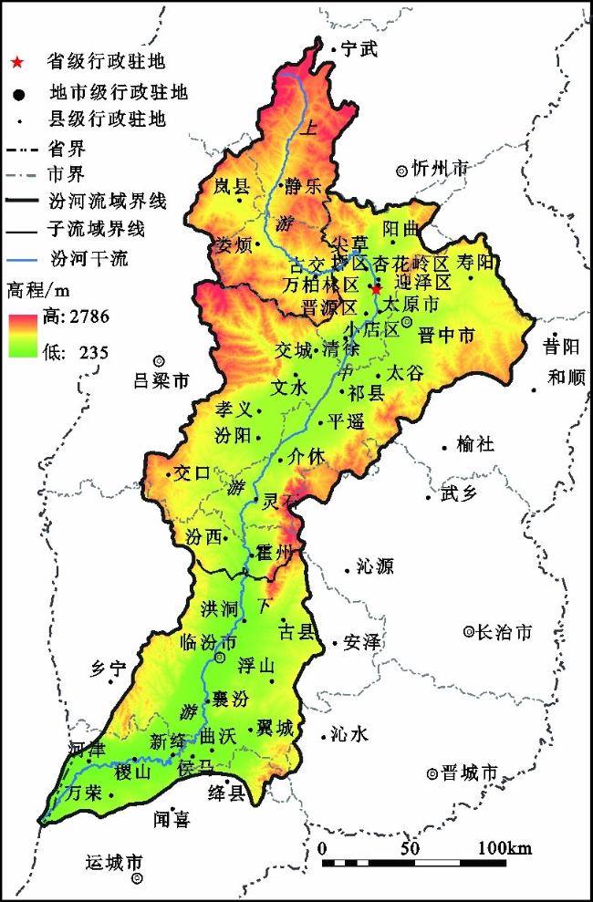
郭文炯, 姜晓丽, 张侃侃, 等. 汾河流域城镇变迁与城镇化[M]. 北京: 科学出版社. 2017.
Guo Wenjiong, Jiang Xiaoli, Zhang Kankan et al. Changes of cities and towns and urbanization in Fenhe Basin. Beijing: Science Press, 2017.
|
| [24] |
星球地图出版社. 1∶70万山西省地图[JS(2019)01-304][Z]. 北京: 星球地图出版社. 2019.
Star Map Publishing. 1∶700, 000 Map of Shanxi Province [JS(2019)01-304]. Beijing: Star Map Press. 2019.
|
| [25] |
山西省统计局, 国家统计局山西调查总队. 山西统计年鉴[M]. 北京: 中国统计出版社,2019.
Shanxi Provincial Bureau of Statistics, Survey Office of the National Bureau of Statistics in Shanxi. Shanxi statistics yearbook. Beijing: China Statistics Press, 2019.
|
| [26] |
国家统计局农村社会经济调查司. 中国县域统计年鉴(县市卷)[M]. 北京: 中国统计出版社. 2019.
Department of Rural Surveys of NBS. China statistical yearbook (County-level). Beijing: China Statistics Press, 2019.
|
| [27] |
国家统计局农村社会经济调查司. 中国县域统计年鉴(乡镇卷)[M]. 北京: 中国统计出版社. 2019.
Department of Rural Surveys of NBS. China statistical yearbook (Township). Beijing: China Statistics Press, 2019.
|
| [28] |
山西省地图集编纂委员会. 汾河流域地图集[M], 西安: 西安地图出版社,2012年.
Map Compiling Committee Office of Shanxi Province. Atlas of the Fenhe River Basin. Xi′an: Xi′an Map Press,2012.
|
| [29] |
彭建, 陈云谦, 胡智超, 等. 城市腹地定量识别研究进展与展望[J]. 地理科学进展, 2016, 35 (1): 14-24.
Peng Jian, Chen Yunqian, Hu Zhichao et al. Research progress and prospect on quantitative identification of urban hinterland area[J]. Progress in Geography, 2016, 35 (1): 14-24.
|
| [30] |
李震, 顾朝林, 姚士谋. 当代中国城镇体系地域空间结构类型定量研究[J]. 地理科学, 2006, 26 (5): 544-550.
Li Zhen, Gu Chaolin, Yao Shimou. A quantitative study on regional spatial structure of urban system in contemporary China[J]. Scientia Geographica Sinica, 2006, 26 (5): 544-550.
|
| [31] |
初楠臣, 姜博, 张雪, 等. 基于现实和虚拟视角的哈大齐空间联系综合测度及驱动力[J]. 经济地理, 2016, 36 (7): 70-75.
Chu Nanchen, Jiang Bo, Zhangxue et al. The comprehensive measure and driving force of spatial connection in Ha-Da-Qi based on the real and virtual perspectives[J]. Economic Geography, 2016, 36 (7): 70-75.
|
| [32] |
黄金川. 基于辐射扩散测度的中国城市群发育格局识别[J]. 经济地理, 2016, 36 (11): 199-206.
Huang Jinchuan. Identification of urban agglomeration in China based on radiation diffusion measurement[J]. Economic Geography, 2016, 36 (11): 199-206.
|
| [33] |
李平华, 陆玉麒. 可达性研究的回顾与展望[J]. 地理科学进展, 2005, 24 (3): 69-78.
Li Pinghua, Lu Yuqi. Review and prospect of accessibility research[J]. Progress in Geography, 2005, 24 (3): 69-78.
|
| [34] |
王振波, 徐建刚, 朱传耿, 等. 中国县域可达性区域划分及其与人口分布的关系[J]. 地理学报, 2010, 65 (4): 416-426.
Wang Zhenbo, Xu Jiangang, Zhu Chuangeng. The county accessibility divisions in China and its correlation with population distribution[J]. Acta Geographica Sinica, 2010, 65 (4): 416-426.
|
| [35] |
潘竟虎, 刘莹. 基于可达性与场强模型的中国地级以上城市空间场能测度[J]. 人文地理, 2014, 29 (1): 80-88.
Pan Jinghu, Liu Yin. Measurements for spatial field of cities at prefecture level or above in China based on accessibility and field-strength model[J]. Human Geography, 2014, 29 (1): 80-88.
|
| [36] |
关兴良, 方创琳, 罗奎. 基于空间场能的中国区域经济发展差异评价[J]. 地理科学, 2012, 32 (9): 1055-1065.
Guan Xingliang, Fang Chuanglin, Luo Kui. Regional economic development disparity of China: An application of spatial field[J]. Scientia Geographica Sinica, 2012, 32 (9): 1055-1065.
|
| [37] |
曲衍波, 姜广辉, 张佰林, 等. 山东省农村居民点转型的空间特征及其经济梯度分异[J]. 地理学报, 2017, 72 (10): 1845-1858.
Qu Yanbo, Jiang Guanghui, Zhang Bailin et al. Spatial characteristics of rural residential land transition and its economic gradient differentiation[J]. Acta Geographica Sinica, 2017, 72 (10): 1845-1858.
|
| [38] |
马晓冬, 李全林, 沈一. 江苏省乡村聚落的形态分异及地域类型[J]. 地理学报, 2012, 67 (4): 516-525.
Ma Xiaodong, Li Quanlin, Shen Yi. Morphological difference and regional types of rural settlements in Jiangsu province[J]. Acta Geographica Sinica, 2012, 67 (4): 516-525.
|
| [39] |
姜海宁. 泛长江三角洲FDI空间格局演化研究[J]. 人文地理, 2015, 30 (6): 126-131+145.
Jiang Haining. Research on spatial pattern evolution of foreign direct investment in Pan-Yangtze River Delta[J]. Human Geography, 2015, 30 (6): 126-131+145.
|
| [40] |
王劲峰, 徐成东. 地理探测器: 原理与展望[J]. 地理学报, 2017, 72 (1): 116-134.
Wang Jinfeng, Xu Chengdong. Geodetector: Principle and prospective[J]. Acta Geographica Sinica, 2017, 72 (1): 116-134.
|
| [41] |
马义娟, 侯志华. 流域生态环境变化及质量评估理论与实践: 以汾河流域为例[M]. 北京: 科学出版社. 2018.
Ma Yijuan, Hou Zhihua. Evaluation of quality for the changes of ecological and environmental: Theory and practice (A case study of Fenhe River Basin). Beijing: Science Press, 2018.
|
| [42] |
侯志华, 刘敏, 姚丹. 基于灯光遥感数据的栅格尺度经济发展空间格局分析——以汾河流域为例[J]. 经济研究参考, 2018 (57): 3-10.
Hou Zhihua, Liu Min, Yao Dan. Spatial pattern analysis of economic development on grid scale using DMSP/OLS data: A case study of Fenhe River Basin[J]. Review of Economic Research, 2018 (57): 3-10.
|
/
| 〈 |
|
〉 |
