
地形因子对反距离加权插值方法(IDW)最优距离指数的影响分析
|
张洁(1998—),女,云南楚雄人,硕士研究生,主要从事空间插值方法研究。E-mail: giserjj163@.com |
收稿日期: 2022-01-16
修回日期: 2022-04-23
网络出版日期: 2023-07-20
基金资助
国家自然科学基金项目(41901336)
云南省基础研究计划项目(202101AT070078)
云南省科技基础专项重点项目(202001AS070032)
“兴滇英才支持计划”项目(YNWR-QNBJ-2020-103)
云南省院士专家工作站项目(2017IC063)
版权
Influence of terrain factors on optimal order distance of Inverse Distance Weighted (IDW)
Received date: 2022-01-16
Revised date: 2022-04-23
Online published: 2023-07-20
Supported by
National Natural Science Foundation of China(41901336)
Yunnan Fundamental Research Projects(202101AT070078)
Yunnan Province Science and Technology Foundation Key Project(202001AS070032)
'Revitalizing Yunnan Talents Support Program' Project(YNWR-QNBJ-2020-103)
Yunnan Academician and Expert Workstation(2017IC063)
Copyright
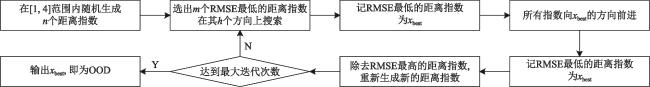
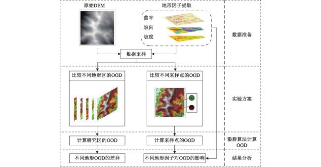
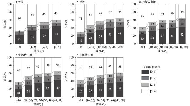
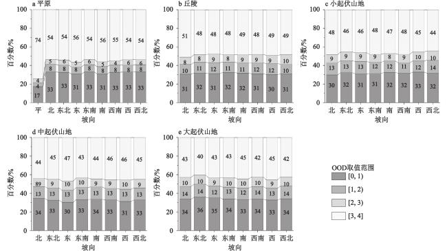
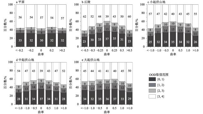
反距离加权插值方法(Inverse Distance Weighted, IDW)是生成数字高程模型(Digital Elevation Model,DEM)的常用内插手段之一,不同的地形应使用合适的IDW距离指数进行插值。本文选取了平原、丘陵、小起伏山地、中起伏山地和大起伏山地5种地形,设计了2组试验,从地形宏观形态和地形微观形态2个方面研究了地形对IDW插值中最优距离指数(Optimal order of distances,OOD)的影响。首先使用狼群算法(Wolf pack algorithm,WPA)计算不同地形区下IDW插值的OOD,分析不同地形之间OOD的分布差异;其次选取坡度、坡向、曲率3个地形因子,计算各采样点的OOD,分析不同地形因子对采样点OOD的影响。结果表明,从平原地区到大起伏山地地区,随着区域内地形起伏度的增加,OOD减小。采样点的OOD在高值区的占比随坡度增大而减小;OOD随坡向变化差异不大;随着地形曲率的增大,OOD在高值区的占比增加,在低值区的占比减小。在较为平坦的地区,例如平原地区,丘陵地区建议使用OOD在3≤a≤4范围内取值进行IDW插值,而在小起伏山地、中起伏山地和大起伏山地等山地区建议采用OOD在1≤a≤2范围内取值进行IDW插值。
关键词: 地形因子; 反距离加权插值方法(IDW); 最优距离指数(OOD); 数字高程模型(DEM)
张洁 , 段平 . 地形因子对反距离加权插值方法(IDW)最优距离指数的影响分析[J]. 地理科学, 2023 , 43(7) : 1281 -1290 . DOI: 10.13249/j.cnki.sgs.2023.07.015
The Inverse Distance Weighted (IDW) is one of the commonly used interpolation methods to generate the Digital Elevation Model (DEM). The appropriate order of distance of IDW should be used to interpolate in different terrains. In order to study the influence of different terrain conditions on the value of Optimal Order of Distance (OOD) in IDW, five types of terrain, including flatlands, hilly low rolling uplands, middle rolling uplands and high rolling uplands, are selected in this paper. In each terrain area, 30 random samples were taken, and each sample contained 2 000 points, and two groups of experiments were designed to study the influence of terrain on the OOD from two aspects of landforms macro and micro morphology. For the macro morphology of the terrain, the wolf pack algorithm (WPA) was used to calculate the OOD of IDW interpolation in different terrain areas. The difference of the OOD was analyzed among different terrain areas. For the micro morphology of the terrain, three terrain factors of slope, aspect and curvature were selected, and the OOD of different sampling points under different terrains was calculated by using WPA, and statistics were made to analyze the influence of different terrain conditions on the OOD of sampling points. The results show that the accuracy of DEM constructed by OOD is higher than that of the order of distance using the value 2, and the value of OOD varies greatly in different terrain areas. From the macro aspect of topography, the OOD is decreasing with the increase of relief and slope from flatland areas to high rolling uplands. From the micro aspect of topography, the proportion of the high-value OOD of sampling points decreases with the increase of slope. The change of aspect makes little influence to the OOD. With the increase of curvature, the proportion of the high-value OOD increases, and the low-value OOD decreases. On the whole, when the influence of terrain factors on the degree of elevation variation increases, that is, when the characteristics of elevation variation change obviously, the smaller OOD gets higher interpolation accuracy. According to different terrain, the different OOD should be chosen. In relatively flat areas, such as flatlands areas and hilly areas, it is recommended to use the OOD in the range of 3≤a≤4 for IDW interpolation. It is recommended to use the OOD in the range of 1≤a≤2 for IDW interpolation in mountain areas such as low rolling uplands, middle rolling uplands, and high rolling uplands areas.
表1 研究区地形基本特征Table 1 Basic topographic features of the study area |
| 地形 | 区域 | 范围 | 地形基本特征 | 区域描述 | |
| 平原 | 江苏 | 5 km×5 km | 最低海拔/m | 2 | 地处119°01′E~119°04′E,33°36′N~33°39′N之间,地势起伏低,坡度小,平均坡度1.57°(图1a) |
| 最高海拔/m | 28 | ||||
| 平均海拔/m | 6.16 | ||||
| 平均坡度/° | 1.57 | ||||
| 丘陵 | 陕西 | 5 km×5 km | 最低海拔/m | 892 | 地处110°37′E~110°40′E,38°23′N~38°26′N之间,海拔低,平均海拔1 009.61m,地势起伏小(图1b) |
| 最高海拔/m | 1113 | ||||
| 平均海拔/m | 1009.61 | ||||
| 平均坡度/° | 10.75 | ||||
| 小起伏山地 | 贵州 | 5 km×5 km | 最低海拔/m | 1773 | 地处104°26′E~104°29′E,25°36′N~25°38′N之间,周围山脉隆起,形成峡谷地形(图1c) |
| 最高海拔/m | 2220 | ||||
| 平均海拔/m | 1995.01 | ||||
| 平均坡度/° | 16.08 | ||||
| 中起伏山地 | 云南 | 5 km×5 km | 最低海拔/m | 1773 | 地处99°47′E~99°50′E,24°14′N~24°17′N之间,地势东高西低(图1d) |
| 最高海拔/m | 2818 | ||||
| 平均海拔/m | 2343.12 | ||||
| 平均坡度/° | 21.96 | ||||
| 大起伏山地 | 西藏 | 5 km×5 km | 最低海拔/m | 3971 | 地处96°29′E~96°32′E,29°33′N~29°37′N之间,地势起伏差异极大,平均坡度为31.3°(图1e) |
| 最高海拔/m | 5573 | ||||
| 平均海拔/m | 4959.97 | ||||
| 平均坡度/° | 31.30 | ||||
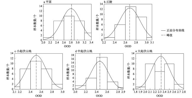
表2 不同地形区域最优距离指数(OOD)占比最高分布区间Table 2 The value range with the highest proportion of optimal order of distances (OOD) in different terrain areas |
| 地形 | 占比最高区间 | 所占比例/% |
| 平原 | (2.6,2.9) | 33.33 |
| 丘陵 | (2.6,2.8] | 43.33 |
| 小起伏山地 | (2.4,2.6) | 36.67 |
| 中起伏山地 | [2.4,2.6) | 56.67 |
| 大起伏山地 | (2.0,2.2) | 33.33 |
表3 不同地形的均方根误差(RMSE)/mTable 3 RMSE of different terrains/m |
| 地形 | IDW-2 | IDW-OOD |
| 平原 | 1.38 | 1.35 |
| 丘陵 | 7.80 | 7.72 |
| 小起伏山地 | 11.32 | 11.25 |
| 中起伏山地 | 16.15 | 16.06 |
| 大起伏山地 | 23.55 | 23.47 |
| [1] |
|
| [2] |
|
| [3] |
|
| [4] |
高超, 金高洁. SWIM水文模型的DEM尺度效应[J]. 地理研究, 2012, 31(3): 399-408.
|
| [5] |
张凯莉, 赵明伟. 面向DEM构建的不同等高线离散化方法适应性分析与评价[J]. 测绘科学技术学报, 2019, 36(4): 424-429,435.
|
| [6] |
|
| [7] |
|
| [8] |
|
| [9] |
段平, 盛业华, 李佳. 自适应的IDW插值方法及其在气温场中的应用[J]. 地理研究, 2014, 33(8): 1417-1426.
|
| [10] |
|
| [11] |
|
| [12] |
|
| [13] |
|
| [14] |
|
| [15] |
|
| [16] |
张磊. 基于核心地形因子分析的黄土地貌形态空间格局研究[D]. 南京: 南京师范大学, 2013.
Zhang Lei. Study on spatial pattern of loesslandform based on core topographic factor analysis. Nanjing: Nanjing Normal University, 2013.
|
| [17] |
张传才, 秦奋, 王海鹰. 砒砂岩区地貌形态三维分形特征量化及空间变异[J]. 地理科学, 2016, 36(1): 142-148.
|
| [18] |
|
| [19] |
|
| [20] |
|
| [21] |
王士博, 王勇. 小区域癌症数据典型空间插值方法比较研究[J]. 地理研究, 2021, 40(7): 2102-2118.
|
| [22] |
|
| [23] |
|
| [24] |
|
| [25] |
颜金彪, 吴波, 何清华. 顾及各向异性的多参数协同优化IDW插值方法[J]. 测绘学报, 2021, 50(5): 675-684.
|
| [26] |
|
| [27] |
|
| [28] |
|
| [29] |
|
| [30] |
|
/
| 〈 |
|
〉 |
