
长白山天池水循环条件分析与水量平衡计算
|
王福刚(1975—),男,辽宁普兰店人,博士研究生,教授,主要从事地下水资源形成演化与可持续利用以及二氧化碳地质封存及其环境效应方面的研究。E-mail: wangfugang@jlu.edu.cn |
收稿日期: 2022-02-11
修回日期: 2022-06-20
网络出版日期: 2023-07-20
基金资助
国家重点研发计划项目(2019YFC0409103)
版权
Water circulation condition and calculation of water balance in Tianchi Lake of the Changbai Mountains
Received date: 2022-02-11
Revised date: 2022-06-20
Online published: 2023-07-20
Supported by
National Program on Key Research and Development Project(2019YFC0409103)
Copyright
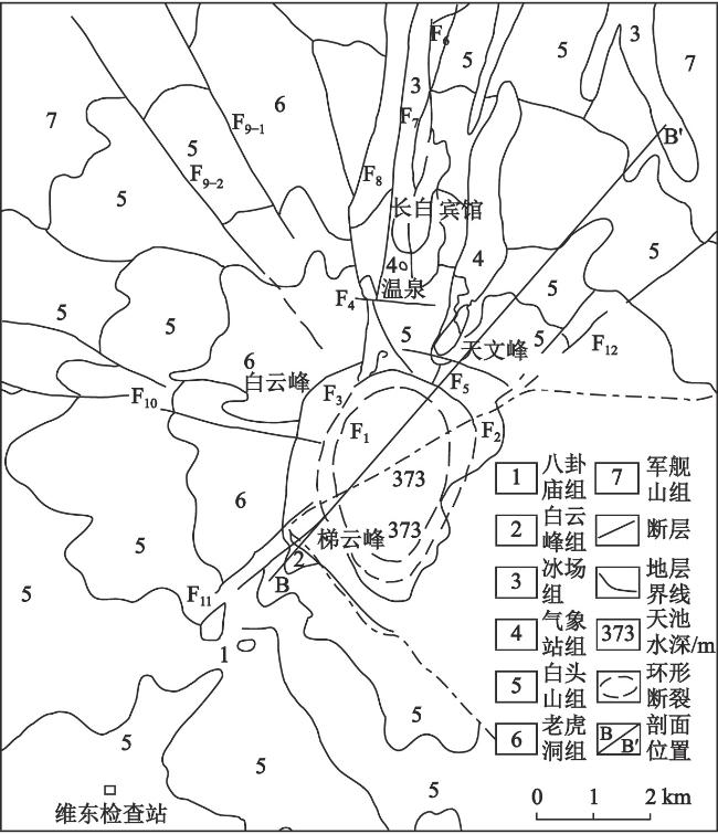
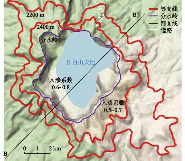
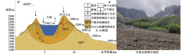
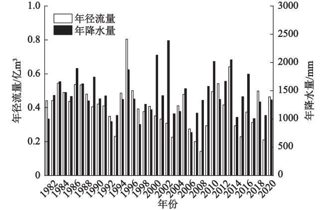
长白山天池区是松花江、鸭绿江、图们江的发源地,也是全国著名的旅游胜地。研究结合天池区地形地貌条件以及特殊的地质岩性和环状-放射状断裂构造特征,分析了天池水循环条件和水动力特征,明确了环状断裂构造的水力“消峰”作用和放射状断裂的导水作用,论证了天池补给区的地下水分水岭外扩的可能性。在天池区水循环与水动力条件分析的基础上,基于天池区2003—2020年气象水文监测数据,利用水均衡法对天池水量平衡进行了计算分析,结果显示,天池区的降水条件可以维持天池的水量平衡,距离环天池地表分水岭外侧高程850~2200 m范围内的大气降水可以维持天池年排泄量3600万m3的水量平衡,水量平衡区对应的地表高程平均高于天池水面(2189.7 m)约125 m。
王福刚 , 王耀辉 , 姜明 , 王贺 , 盘惠林 , 吴铭杰 , 曹玉清 . 长白山天池水循环条件分析与水量平衡计算[J]. 地理科学, 2023 , 43(7) : 1291 -1298 . DOI: 10.13249/j.cnki.sgs.2023.07.016
It is of great significance to explore the formation of water resources and the water balance in Tianchi area for the protection of water resources and ecological environment. Based on the topographic and geomorphologic conditions, the special geological lithology and ring-radial fault structure characteristics of Tianchi area, the water circulation conditions and hydrodynamic characteristics of Tianchi Lake were analyzed. The "hydraulic peak elimination" effect of the ring fault structure and the water conduction effect of the radial fault are clarified, and the possibility of groundwater divide expansion in Tianchi recharge area is demonstrated. Based on the analysis of water circulation and hydrodynamic conditions in Tianchi area, and meteorological and hydrological monitoring data of Tianchi area from 2003 to 2020, the water balance of Tianchi Lake was calculated and analyzed based on the water balance method. The results show that the precipitation conditions in Tianchi area can maintain the water level balance of Tianchi Lake. The water balance of annual excretion of 3.6×10⁷m3 of Tianchi Lake can be maintained when the precipitation is within 850-2 200 m from the outside of the surface watershed around Tianchi Lake. The average surface elevation of the water balance area is 125 m higher than that of Tianchi water surface (2 189.7 m). many ring faults and radial faults in Tianchi area. All the above faults are tensile faults. The ring faults all inclined to Tianchi which provided favorable conditions for groundwater recharge to Tianchi Lake. The formation above 1700 m in Tianchi area is mainly composed of pumice rock and pyroclastic rock, mostly of porosity structure and strong permeability. The special geological structure conditions and stratigraphic lithology in Tianchi area make the surface divide around Tianchi not coincide with the underground watershed in the groundwater recharge area. The dominant seepage conditions of the fault structure around Tianchi constitute the "peak elimination" effect of groundwater potential energy. The ring-radial fault structure and the good permeability of the stratum lithology in Tianchi area make it possible to expand the groundwater watershed. Combined the synthetic analysis result of the of water circulation and hydrodynamic conditions in Tianchi area, and meteorological and hydrological monitoring data of Tianchi area from 2003 to 2020, the water balance of Tianchi Lake was calculated and analyzed based on the water balance method. The results show that the precipitation conditions in Tianchi area can maintain the water balance of annual excretion of 3.6×10⁷ m3 of Tianchi Lake. The distance of the water balance zone boundary is within 850-2 200 m from the outside of the surface watershed around Tianchi Lake. The average surface elevation of the water balance area is 125 m higher than that of Tianchi Lake water surface (2 189.7 m). The factors that may affect the calculation result of water balance, such as precipitation, runoff of Tianchi Lake water, calculation parameter value, condensation water amount and evaporation amount, are analyzed and discussed.
图2 天池区遥感图及可能地下汇水区范围(基于谷歌遥感影像修改)Fig. 2 Remote sensing map of the Tianchi area and extent of possible underground catchment area (modifiedby Google remote sensing image) |
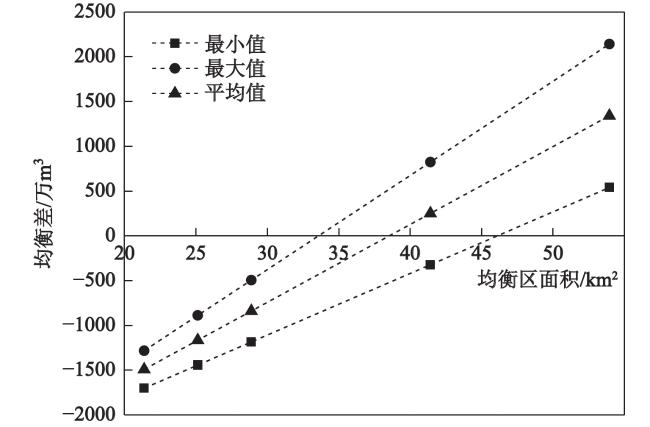
表1 天池水均衡计算结果Table 1 Calculation results of Tianchi water balance |
| 方案 编号 | 高程/m | 面积/km2 | 陆地面积/km2 | 总补给量/(万m3/a) | 均衡差/(万m3/a) | |||||
| 最小值 | 最大值 | 平均值 | 最小值 | 最大值 | 平均值 | |||||
| 1 | 地表分水岭内 | 21.37 | 11.55 | 2297.06 | 2713.39 | 2505.23 | -1742.94 | -1326.61 | -1534.77 | |
| 2 | ≥ 2500 | 25.12 | 15.30 | 2552.87 | 3104.37 | 2828.62 | -1487.13 | -935.63 | -1211.38 | |
| 3 | ≥ 2400 | 28.87 | 19.05 | 2808.67 | 3495.35 | 3152.01 | -1231.33 | -544.65 | -887.99 | |
| 4 | ≥ 2300 | 41.41 | 31.59 | 3663.75 | 4802.26 | 4233.00 | -376.25 | 762.26 | 193.00 | |
| 5 | ≥ 2200 | 53.94 | 44.12 | 4518.82 | 6109.17 | 5314.00 | 478.82 | 2069.17 | 1274.00 | |
| [1] |
|
| [2] |
凌思宁, 陈卫, 陆日宇, 等. 夏季长白山天池站降水量年际变化特征及其对应的环流异常[J]. 大气科学, 2021, 45(3): 499-512.
|
| [3] |
衣健, 王璞珺, 单玄龙, 等. 长白山天池火山千年大喷发火山碎屑流堆积相特征[J]. 岩石学报, 2020, 36(11): 3346-3362.
|
| [4] |
许建东, 万园, 王新茹, 等. 中国火山灾害区划研究历史回顾与未来展望[J]. 地质与资源, 2022, 31(3): 426-433.
|
| [5] |
李玥, 吴珍汉, 杨智. 长白山天池水系常量离子和氢氧同位素地球化学示踪[J]. 科学技术与工程, 2015, 15(6): 16-20.
|
| [6] |
林元武, 高清武, 于清桐. 长白山天池火山区地下热流体化学特征研究[J]. 地质论评, 1999, 45(S1): 241-247.
|
| [7] |
林元武, 高清武, 于清桐. 长白山天池火山区长白聚龙泉热水氢氧稳定同位素组成与氚分布规律[J]. 地质论评, 1999, 45(S1): 236-240.
|
| [8] |
|
| [9] |
|
| [10] |
|
| [11] |
方展, 卞建民, 孙晓庆, 等. 吉林省抚松县矿泉水形成机理及过程模拟[J]. 科学技术与工程, 2017, 17(14): 39-44.
|
| [12] |
朱颜明, 佘中盛, 富德义, 等. 长白山天池水化学[J]. 地理科学, 1981(1): 58-65.
|
| [13] |
张兴库, 朴观熙. 长白山天池水文特性分析[J]. 水文, 1991(2): 49-51.
|
| [14] |
林琳, 王屹林. 长白山天池水资源综合研究[J]. 吉林地质, 2019, 38(1): 60-66+101.
|
| [15] |
江巧宁, 陈建生. 深循环地下水补给长白山天池的水量平衡分析[J]. 水资源保护, 2015, 31(5): 7-13.
|
| [16] |
刘若新, 樊祺诚, 郑祥身, 等. 长白山天池火山的岩浆演化[J]. 中国科学(D辑:地球科学), 1998(3): 226-231.
|
| [17] |
金伯禄, 张希友. 长白山火山地质研究[M]. 延吉: 东北朝鲜民族教育出版社, 1994.
Jin Bolu, Zhang Xiyou. Researching volcanic geology in Mount Changbai. Yanji: Northeast Korean Ethnic Education Press, 1994.
|
| [18] |
阮帅, 汤吉, 董泽义, 等. 基于三维大地电磁AR-QN反演的长白山天池火山区电性结构[J]. 地震地质, 2020, 42(6): 1282-1300.
|
| [19] |
李霓, 刘若新, 魏海泉, 等. 长白山天池火山近代喷发中气象站组熔岩—碎屑岩流研究[J]. 地质论评, 1999, 45(S1): 272-277.
|
| [20] |
潘波, 樊祺诚, 许建东, 等. 长白山天池火山千年大喷发的岩浆过程[J]. 岩石学报, 2017, 33(1): 163-172.
|
| [21] |
钱程, 崔天日, 唐振, 等. 长白山天池火山造锥阶段玄武质火山活动期次划分及成因探讨[J]. 中国地质, 2016, 43(6): 1963-1976.
|
| [22] |
刘嘉麒. 中国东北地区新生代火山岩的年代学研究[J]. 岩石学报, 1987(4): 21-31.
|
| [23] |
郭文峰, 刘永顺, 吴才来, 等. 长白山天池火山气象站期碱流岩辉石环带混沌吸引子的发现及意义[J]. 科学通报, 2017, 62(30): 3470-3478.
|
| [24] |
潘波, 程滔, 徐丹, 等. 长白山天池火山天文峰期黄色浮岩成因研究[J]. 岩石学报, 2020, 36(7): 2067-2080.
|
| [25] |
王璞珺, 许伟东, 陈海潮, 等. 长白山天池火山千年大喷发期后火山泥石流沉积特征及其源-汇响应关系[J]. 岩石学报, 2020, 36(9): 2893-2911.
|
| [26] |
王禹钦, 于红梅, 许建东, 等. 长白山天池火山千年大喷发2期空降浮岩对比[J]. 地震地质, 2019, 41(1): 208-224.
|
| [27] |
缪韧. 水文学原理[M]. 北京: 中国水利水电出版社, 2007.
Miu Ren. Principle of Hydrology. Beijing: China Water Resources and Hydropower Press, 2007: 14-15.
|
| [28] |
左其亭, 吴青松, 金君良, 等. 区域水平衡基本原理及理论体系[J]. 水科学进展, 2022, 33(2): 165-173.
|
| [29] |
张人权, 梁杏, 靳孟贵, 等. 水文地质学基础[M]. 北京: 地质出版社, 2011.
Zhang Renquan, Liang Xing, Jin Menggui et al. Fundamentals of Hydrogeology. Beijing: Geological Publishing House, 2011.
|
| [30] |
|
| [31] |
|
| [32] |
黄锡昌, 汪武精, 梁新南. 海南省琼山县龙桥玄武岩水源地调查研究报告[R]. 海口: 海南大学, 1991.
|
| [33] |
捷尔普戈里兹 В Ф. 水的世界[M]. 北京: 科学出版社, 1983.
Gerpgoritz В Ф. Water world. Beijing: Science Press, 1983.
|
/
| 〈 |
|
〉 |