
长江干线过江公路发展过程及其区域连通能力评价
|
陈娱(1989—),女,江苏镇江人,副教授,研究方向为交通地理与区域发展。E-mail: chenyu@lreis.ac.cn |
收稿日期: 2022-06-14
修回日期: 2022-10-23
网络出版日期: 2023-10-20
基金资助
国家自然科学基金项目(42171173)
国家自然科学基金项目(42171171)
国家社会科学基金重大项目(20&ZD099)
江苏省高等学校基础学科(自然科学)面上项目(21KJB170012)
版权
Development of cross the Yangtze River highways and their regional connectivity evaluation
Received date: 2022-06-14
Revised date: 2022-10-23
Online published: 2023-10-20
Supported by
National Natural Science Foundation of China(42171173)
National Natural Science Foundation of China(42171171)
Major Program of National Social Science Foundation of China(20&ZD099)
Jiangsu Province Higher Education Basic Discipline (Natural Science) General Project(21KJB170012)
Copyright
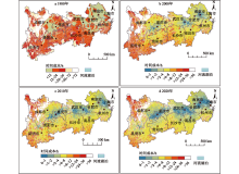
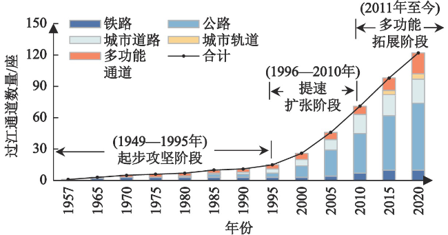
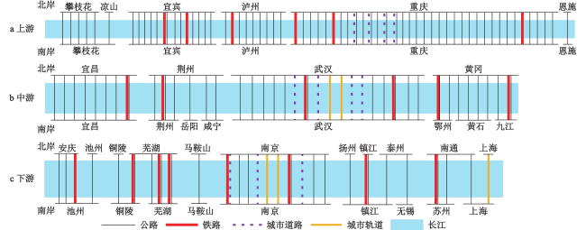
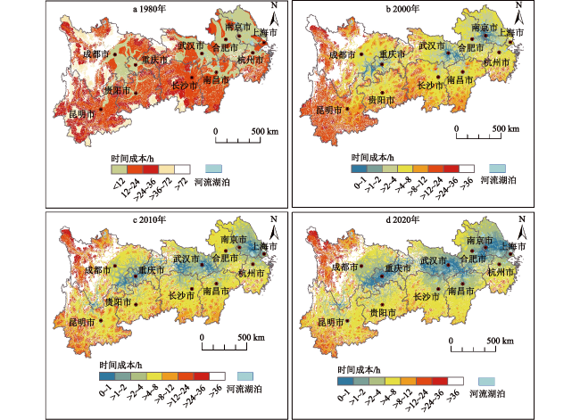
过江通道是打破自然阻隔、连通长江南北的重要交通基础设施,对推动跨江融合、支撑长江经济带发展和实现全国南北要素流动具有重要意义。本文梳理了中国长江干线过江通道的发展过程,并采用时间可达性和中介中心性对过江公路的区域连通能力进行了评价。研究表明:① 根据数量、类型和社会经济发展背景,长江干线过江通道的建设过程可分为起步攻坚阶段(1957—1995年)、提速扩张阶段(1996—2010年)和多功能拓展阶段(2011年至今),至2021年6月,上中下游过江通道比例达54.7∶23.4∶21.9,从经济规模和常住人口来看,长江下游过江通道密度远低于上中游地区;② 长江经济带平均公路过江时间由1980年的19.73 h下降到2020年的6.09 h,可达性显著提升,且上、中、下游过江时间成本差距不断缩小;③ 长江南北两岸地市间跨江连通水平提升显著,过江最短路径由高度依赖于若干过江公路发展为多条过江公路共同分担,高中介中心性过江公路主要布局在长江中下游地区,而上游地区过江公路连通能力普遍偏弱。
陈娱 , 王峰 , 陆玉麒 . 长江干线过江公路发展过程及其区域连通能力评价[J]. 地理科学, 2023 , 43(10) : 1691 -1700 . DOI: 10.13249/j.cnki.sgs.2023.10.001
Cross the Yangtze River passages are of great significance in promoting integration of metropolitans, supporting the development of the Yangtze River Economic Belt and realizing the flow of elements between the north and the south of China. This paper sorts out the development of cross the Yangtze River passages on the Yangtze River mainline, and evaluates the regional connectivity of cross the Yangtze River highways using accessibility and weighted betweenness centrality. The study shows that: 1) according to the quantity, type and socio-economic development background, the construction process of passages can be divided into the initial stage (1957—1995), the speed-up expansion stage (1996—2010) and the multi-functional expansion stage (2011—). By June 2021, the ratio of passages in the upper, middle and lower the Yangtze River reaches is 54.7∶23.4∶21.9, while in terms of economic scale and resident population, the density of passages in the lower the Yangtze River reaches is much lower than that in the upper and middle reaches. 2) The accessibility of cross the Yangtze River highways has been significantly improved from 19.73 h to 6.09 h, and the time cost gap between the upper, middle and lower the Yangtze River reaches is narrowing; 3) The level of connectivity is substantially strengthened. The shortest path across the Yangtze River changes from highly dependent on several highways to multiple sharing. The high betweenness centrality highways are mainly located in the middle and lower reaches of the Yangtze River, while the connectivity of highways in the upper reaches is generally weak.
表1 分地区分类型长江干线过江通道建设情况(截止至2021年6月)Table 1 Statistics of cross the Yangtze River passages by reaches and types (by June, 2021) |
| 地区 | 功能分类/座 | 密度 | ||||||||
| 公路 | 铁路 | 城市道路 | 城市轨道 | 多功能 | 合计 | 岸线长度视角 (座/100 km) | GDP视角 (座/104亿元) | 常住人口视角 (座/107人) | ||
| 注: GDP数据来源于各地市2020年统计公报,常住人口数据来源于各地市第七次人口普查公报。 | ||||||||||
| 上游 | 39 | 8 | 15 | 0 | 8 | 70 | 1.35 | 16.53 | 11.16 | |
| 中游 | 14 | 0 | 6 | 3 | 7 | 30 | 4.08 | 12.35 | 9.92 | |
| 下游 | 16 | 2 | 2 | 2 | 6 | 28 | 2.98 | 2.14 | 3.03 | |
| 合计 | 69 | 10 | 23 | 5 | 21 | 128 | 2.00 | 6.42 | 6.87 | |
| [1] |
中国大百科全书委员会. 中国大百科全书·中国地理[M]. 北京: 中国大百科全书出版社, 1993.
Committee of Chinese Encyclopedia. Encyclopedia of China·Geography of China. Beijing: Encyclopedia of China Press, 1993.
|
| [2] |
国家发展改革委. 长江干线过江通道布局规划(2020—2035年)[EB/OL]. http://www.gov.cn/zhengce/zhengceku/2020-04/08/5500124/files/0dfd9795be8b47c2a6e3fcd19bfec723.pdf, 2020-03-31.
National Development and Reform Commission. Planning of the main stream of the Yangtze River crossing the river (2020-2035). http://www.gov.cn/zhengce/zheng-ceku/2020-04/08/5500124/files/0dfd9795be8b47c2a6e3fcd19bfec723.pdf, 2020-03-31.2020-03-31.
|
| [3] |
刘玮辰, 曹有挥, 吴威,等. 长江下游地区过江通道发展利用与“时空压缩”的演变特征[J]. 地理研究, 2019, 38(8): 1905-1918.
Liu Weichen, Cao Youhui, Wu Wei et al. Development and spatio-temporal evolution of cross the Yangtze River highway passages in the lower the Yangtze River region. Geographical Research, 2019, 38(8): 1905-1918.
|
| [4] |
明立波, 甄峰, 郑俊. 无锡-南通过江通道建设构想及其区域经济影响评价[J]. 人文地理, 2007, 22(4): 105-109.
Ming Libo, Zhen Feng, Zheng Jun. The conception of Wuxi-Nantong cross-river passage construction and the evaluation of its regional economic impact. Human Geography, 2007, 22(4): 105-109.
|
| [5] |
刘玮辰, 曹有挥, 梁双波,等. 过江通道对长江两岸城市空间联系的影响——以长三角地区为例[J]. 经济地理, 2020, 40(7): 49-56.
Liu Weichen, Cao Youhui, Liang Shuangbo et al. Spatial effects of cross the Yangtze River highway passage on interurban linkages in the Yangtze River Delta. Economic Geography, 2020, 40(7): 49-56.
|
| [6] |
Liu W, Cao Y, Wu W et al. Spatial impact analysis of trans-the Yangtze River highway fixed links: A case study of the Yangtze River Delta, China[J]. Journal of Transport Geography, 2020, 88: 102822
|
| [7] |
张文尝, 金凤君, 樊杰. 交通经济带[M]. 北京: 科学出版社, 2002.
Zhang Wenchang, Jin Fengjun, Fan Jie. Traffic economic belt. Beijing: Science Press, 2002.
|
| [8] |
汪德根, 孙枫. 长江经济带陆路交通可达性与城镇化空间耦合协调度[J]. 地理科学, 2018, 38(7): 1089-1097.
Wang Degen, Sun Feng. Geographic patterns and coupling-coordination between urbanization and land transportation accessibility in the Yangtze River Economic Zone. Scientia Geographica Sinica, 2018, 38(7): 1089-1097.
|
| [9] |
汪德根, 范子祺, 赵美风. 长江经济带主要城市群2h出行交通圈格局特征[J]. 地理研究, 2022, 41(5): 1388-1406.
Wang Degen, Fan Ziqi, Zhao Meifeng. Spatial pattern of 2h travel circle of major urban agglomerations in the Yangtze River Economic Belt. Geographical Research, 2022, 41(5): 1388-1406.
|
| [10] |
傅钰, 钟业喜, 冯兴华. 长江经济带陆路交通可达性格局演变研究[J]. 长江流域资源与环境, 2016, 25(10): 1484-1491.
Fu Yu, Zhong Yexi, Feng Xinghua. Research of the Yangtze River Economic Belt land transport accessibility pattern change. Resources and Environment in the Yangtze River Basin, 2016, 25(10): 1484-1491.
|
| [11] |
宋仁波, 张余庆, 张迎昭,等. 长江干流县域交通优势度的空间格局[J]. 长江流域资源与环境, 2020, 29(12): 2607-2619.
Song Renbo, Zhang Yuqing, Zhang Yingzhao et al. The spatial pattern of traffic superiority degree of the counties along the mainstreams of the Yangtze River. Resources and Environment in the Yangtze River Basin, 2020, 29(12): 2607-2619.
|
| [12] |
吕承超, 宫攀. 长江经济带交通基础设施空间均衡度研究[J]. 人文地理, 2016, 31(6): 137-144+160.
Lv Chengchao, Gong Pan. Research on spatial equilibrium of transport infrastructure in the Yangtze River Economic Belt. Human Geography, 2016, 31(6): 137-144+160.
|
| [13] |
孙尚志, 梁勇. 长江干流地区跨世纪交通运输网络建设的总体构想[J]. 经济地理, 1996,16(1): 53-59.
Sun Shangzhi, Liang Yong. Overall conception on the construction of communications network across the century in the region of main stream of the Yangtze River. Economic Geography, 1996,16(1): 53-59.
|
| [14] |
王成金, 程佳佳, 马丽. 长江立体化综合交通运输走廊的空间组织模式[J]. 地理科学进展, 2015, 34(11): 1441-1448.
Wang Chengjin, Cheng Jiajia, Ma Li. Spatial organization pattern of the Yangtze River integrated transport corridor. Progress in Geography, 2015, 34(11): 1441-1448.
|
| [15] |
贾文通, 黄震方, 刘俊,等. 高铁对区域旅游“时空压缩”效应的测度与分析——以长江经济带为例[J]. 地理研究, 2021, 40(6): 1785-1802.
Jia Wentong, Huang Zhenfang, Liu Jun et al. Measuring and analyzing the time-space compression of high-speed rail on regional tourism: A case study of the Yangtze River Economic Belt, China. Geographical Research, 2021, 40(6): 1785-1802.
|
| [16] |
邵海雁, 靳诚, 薛晨璐,等. 高铁引起的可达性改善与旅游网络关注度变化耦合协调研究——以沪昆高铁为例[J]. 地理与地理信息科学, 2021, 37(6): 120-128.
Shao Haiyan, Jin Cheng, Xue Chenlu et al. Coupling coordination between accessibility improvement caused by high-speed railway and the change of tourism network attention: A case study of Shanghai-Kunming High-Speed Railway. Geography and Geo-Information Science, 2021, 37(6): 120-128.
|
| [17] |
曹有挥. 长江沿岸港口体系空间结构研究[J]. 地理学报, 1999, 54(3): 233-240.
Cao Youhui. On the spatial structure of the Yangtze River port system. Acta Geographica Sinica, 1999, 54(3): 233-240.
|
| [18] |
Zheng J, Yang D. Hub-and-spoke network design for container shipping along the Yangtze River[J]. Journal of Transport Geography, 2016, 55: 51-57.
|
| [19] |
叶士琳, 曹有挥, 王佳韡,等. 长江沿岸港口物流发展格局演化及其机制[J]. 地理研究, 2018, 37(5): 925-936.
Ye Shilin, Cao Youhui, Wang Jiawei et al. Spatio-temporal evolution characteristics and mechanism of the port logistics system along the Yangtze River. Geographical Research, 2018, 37(5): 925-936.
|
| [20] |
蒋海兵, 徐建刚, 商硕. 过江通道对乡镇可达性影响分析[J]. 长江流域资源与环境, 2010, 19(5): 506-513.
Jiang Haibing, Xu Jiangang, Shang Shuo. Analysis on the impact of the cross the Yangtze River passage on town's accessibility: A case of Su-Tong Bridge. Resources and Environment in the Yangtze River Basin, 2010, 19(5): 506-513.
|
| [21] |
Wu Q, Fan J, Zhang H et al. The spatial impacts model of trans-strait fixed links: A case study of the Pearl River Delta, China[J]. Journal of Transport Geography, 2017, 63: 30-39.
|
| [22] |
吴旗韬, 樊杰, 张虹鸥,等. 跨海通道空间效益模型——以珠江口跨海通道为例[J]. 地理研究, 2015, 34(11): 2061-2072.
Wu Qitao, Fan Jie, Zhang Hongou et al. Spatial effects of different fixed links on accessibility and regional economic linkage in Pearl River Delta. Geographical Research, 2015, 34(11): 2061-2072.
|
| [23] |
吴旗韬, 张虹鸥, 叶玉瑶,等. 基于交通可达性的港珠澳大桥时空压缩效应[J]. 地理学报, 2012, 67(6): 723-732.
Wu Qitao, Zhang Hongou, Ye Yuyao et al. The impact of Hong Kong-Zhuhai-Macao Bridge on the traffic pattern of Pearl River Delta. Acta Geographica Sinica, 2012, 67(6): 723-732.
|
| [24] |
黄振东, 杨斌. 港珠澳大桥驱动下珠江两岸经济关联格局演变[J]. 世界地理研究, 2017, 26(3): 96-104.
Huang Zhendong, Yang Bin. Economic linkage of the Pearl River Delta driven by the Hong Kong-Zhuhai-Macao Bridge. World Regional Studies, 2017, 26(3): 96-104.
|
| [25] |
蓝志威, 吴旗韬, 周智勇. 深圳-中山跨珠江通道对珠江三角洲地区可达性的空间效应[J]. 热带地理, 2016, 36(6): 1019-1025.
Lan Zhiwei, Wu Qitao, Zhou Zhiyong. Spatial effects of Shenzhen-Zhongshan Bridge on regional accessibility in the Pearl River Delta. Tropical Geography, 2016, 36(6): 1019-1025.
|
| [26] |
孙峰华, 陆大道, 柳新华,等. 中国物流发展对渤海海峡跨海通道建设的影响[J]. 地理学报, 2010, 65(12): 1507-1521.
Sun Fenghua, Lu Dadao, Liu Xinhua et al. Influence of the development of China's logistics on the construction of Trans-Bohai Strait Passageway. Acta Geographica Sinica, 2010, 65(12): 1507-1521.
|
| [27] |
王泽东, 孙海燕, 徐建斌,等. 胶州湾跨海通道对区域交通可达性的空间影响[J]. 经济地理, 2018, 38(12): 40-49.
Wang Zedong, Sun Haiyan, Xu Jianbin et al. The spatial influence of Kiaochow Bay Subsea Tunnel on regional traffic accessibility. Economic Geography, 2018, 38(12): 40-49.
|
| [28] |
高鑫, 孙峰华, 李山,等. 渤海海峡跨海通道建设对环渤海陆路物流网络格局的影响[J]. 经济地理, 2018, 38(11): 141-149.
Gao Xin, Sun Fenghua, Li Shan et al. Influence of the construction of the Bohai Strait Cross-Sea Channel to the land logistics network pattern in the Bohai Rim Region. Economic Geography, 2018, 38(11): 141-149.
|
| [29] |
郭欢欢, 林坚, 孙芬,等. 桥梁-道路建设对西南山地城市扩展影响机制研究——以重庆嘉陵江两桥为例[J]. 长江流域资源与环境, 2017, 26(1): 47-54.
Guo Huanhuan, Lin Jian, Sun Fen et al. Impact mechanism of bridge-road construction on urban growth in mountain cities in Southwest China. Resources and Environment in the Yangtze River Basin, 2017, 26(1): 47-54.
|
| [30] |
宋炳良. 杭州湾建桥后沪甬两港竞争力变化分析[J]. 经济地理, 2009, 29(11): 1803-1807.
Song Bingliang. The changes to port competitiveness of Shanghai and Ningbo with the availability of Hangzhou Bay Bridge. Economic Geography, 2009, 29(11): 1803-1807.
|
| [31] |
卢银桃, 尹海伟. 南京过江通道建设对江北沿江地区可达性的影响[J]. 国际城市规划, 2013, 28(2): 69-74.
Lu Yintao, Yin Haiwei. Accessibility Influence on North Bank of the Yangtze River in Nanjing from Building River-crossing Passage. Urban Planning International, 2013, 28(2): 69-74.
|
| [32] |
张建春, 陆林. 芜湖长江大桥与安徽旅游交通条件的改善[J]. 人文地理, 2002,5(4): 75-79.
Zhang Jianchun, Lu Lin. Wuhu Changjiang Bridge and the improvement of tourist traffic condition in Anhui Province. Human Geography, 2002,5(4): 75-79.
|
| [33] |
吴巍, 周生路, 杨得志,等. 跨江通道对滨江副城住宅地价增值效应的测算——以南京市浦口区为例[J]. 地理研究, 2013, 32(1): 29-40.
Wu Wei, Zhou Shenglu, Yang Dezhi et al. Estimation of the value-added effect on residential land price in riverfront sub-city owing to river-crossing channels: A case study of Pukou District of Nanjing City, China. Geographical Research, 2013, 32(1): 29-40.
|
| [34] |
王姣娥, 莫辉辉, 金凤君. 中国航空网络空间结构的复杂性[J]. 地理学报, 2009, 64(8): 899-910.
Wang Jiao'e, Mo Huihui, Jin Fengjun. Spatial structural characteristics of Chinese aviation network based on complex network theory. Acta Geographica Sinica, 2009, 64(8): 899-910.
|
| [35] |
焦敬娟, 王姣娥, 金凤君, 等. 高速铁路对城市网络结构的影响研究——基于铁路客运班列分析[J]. 地理学报, 2016, 71(2): 265-280.
Jiao Jingjuan, Wang Jiaoe, Jin Fengjun, et al. Impact of high- speed rail on inter-city network based on the passenger train network in China, 2003-2013. Acta Geographica Sinica, 2016, 71(2): 265-280.
|
| [36] |
王姣娥, 焦敬娟, 黄洁, 等. 交通发展区位测度的理论与方法[J]. 地理学报, 2018, 73(4): 666-676.
Wang Jiaoe, Jiao Jingjuan, Huang Jie et al. Theory and methodology of transportation development and location measures. Acta Geographica Sinica, 2018, 73(4): 666-676.
|
| [37] |
涂建军, 毛凯, 况人瑞, 等. 长江经济带三大城市群城际客运联系网络结构对比分析[J]. 世界地理研究, 2021, 30(1): 69-79.
Tu Jianjun, Mao Kai, Kuang Renrui et al. A comparative analysis of the intercity passenger transport network structure of three urban agglomerations in the Yangtze River Economic Belt. World Regional Study, 2021, 30(1): 69-79.
|
| [38] |
中华人民共和国交通运输部. 公路工程技术标准: JTGB01-2014[S]. 北京: 人民交通出版社, 2014.
Ministry of Transport of the People's Republic of China. Technical standard for highway engineering: JTGB01-2014. Beijing: People's Communications Press, 2014.
|
| [39] |
Freeman L C. A set of measures of centrality based on betweenness[J]. Sociometry, 1977, 40(1): 35-41.
|
| [40] |
刘文祥. 清末民初的武汉长江大桥建设计划[J]. 档案记忆, 2018(4): 7-10.
Liu Wenxiang. Construction plan for Wuhan the Yangtze River Bridge in the Late Qing and the Early Republic of China. Archives Memory, 2018(4): 7-10.
|
/
| 〈 |
|
〉 |
