
考虑水系三维连通特征的湘江流域洪水风险评价
|
杨柳(1986—),女,湖南永州人,博士,副教授,研究方向为流域水文效应与防灾减灾。E-mail: palapalayl2006@126.com |
收稿日期: 2023-09-17
修回日期: 2023-12-25
网络出版日期: 2025-04-07
基金资助
国家自然科学基金项目(41901026)
国家自然科学基金项目(42001024)
湖南省自然科学基金项目(2025JJ50199)
湖南省自然科学基金项目(2022JJ40015)
版权
Considering characteristics of three-dimensional river system connectivity on flood risk assessment in the Xiangjiang River Basin
Received date: 2023-09-17
Revised date: 2023-12-25
Online published: 2025-04-07
Supported by
National Natural Science Foundation of China(41901026)
National Natural Science Foundation of China(42001024)
Hunan Province Natural Science Foundation(2025JJ50199)
Hunan Province Natural Science Foundation(2022JJ40015)
Copyright
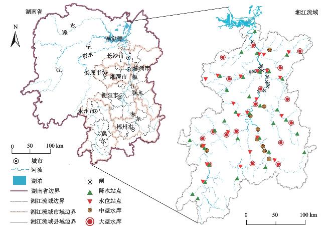
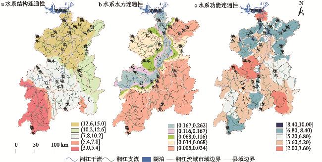
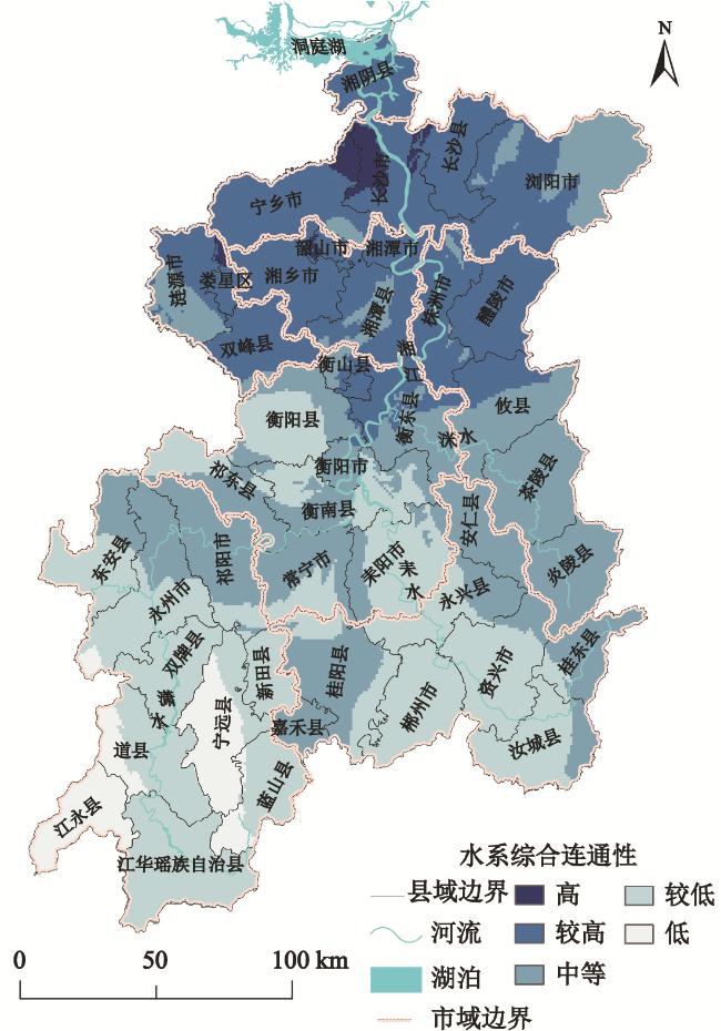
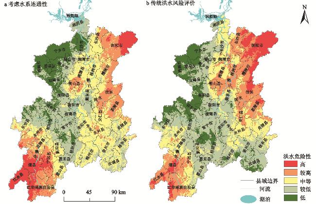
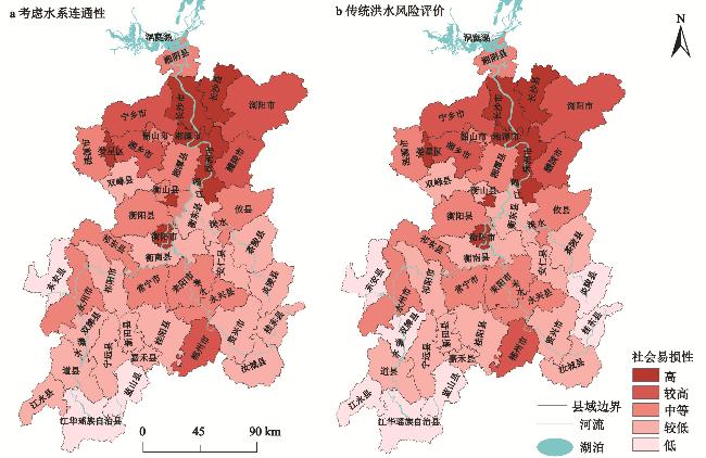
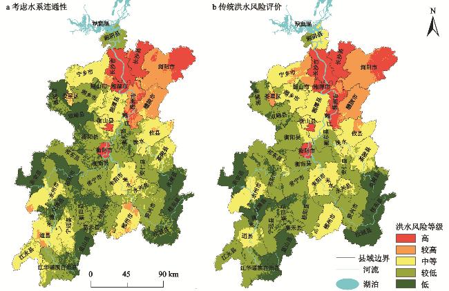
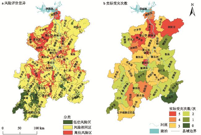
针对传统洪水风险评价中考虑距水远近或部分水系数量指标而未考虑水系连通性对区域洪水风险的影响问题,本研究建立水系连通性三维度综合评价体系,基于此构建考虑水系连通性的洪水风险评价指标体系,采用更为客观的博弈论组合赋权法确定最优权重,自然与行政边界结合应用地图学中范围法绘制专题地图,并以湘江流域为例,研究基于水系连通性相较于传统洪水风险评价体系是否更具可行性与优越性。结果表明:①湘江流域的结构连通性和综合连通性自南向北增强,功能连通性北部水系也强于南部;干流水力连通性高于支流,下游支流水力连通性高于上中游支流。②流域内洪水风险整体从南向北递增,中风险区和较低风险区面积占59.25%,其中,中等风险区集中于湘江流域北部,及湘江流域西南部和南部中部地区,面积占25.01%;低与较低风险区集中于南部山区及西部边缘区,面积分别占22.48%、34.24%;高与较高风险区集中于湘江下游,面积分别占9.34%、8.94%。③传统洪水风险评价低估了流域上游地区洪水风险,而高估了下游地区的洪水风险。结合湘江流域近年实际洪灾情况发现考虑水系连通性相较于传统方式刻画洪水风险评价结果更为客观细腻,能进一步提高洪水风险评价的科学性。
杨柳 , 刘丹 , 冯畅 , 项瑾 , 彭璐璐 , 潘光波 . 考虑水系三维连通特征的湘江流域洪水风险评价[J]. 地理科学, 2025 , 45(3) : 627 -639 . DOI: 10.13249/j.cnki.sgs.20230667
The traditional flood risk evaluation takes into account the effects of regional flood risk solely, based on proximity to water or the number of partial river network systems, without considering the impact of river network system connectivity. To address the problem, this study proposes a three-dimensional comprehensive evaluation system for assessing the connectivity within a river network system. The flood risk assessment index system, which considers the connectivity of river systems, is developed based on this framework. Furthermore, a more objective game-theoretic combination weighting method is employed to determine the optimal weights, and the cartographic method for thematic mapping is applied by integrating natural and administrative boundaries. In the case of the Xiangjiang River Basin, this study investigates the feasibility and superiority of the system compared to the conventional flood risk assessment approach. The findings indicate that: 1) The structural connectivity and comprehensive connectivity of the Xiangjiang River Basin increase from south to north, and the functional connectivity of the northern rivers is stronger than that of the southern rivers. The hydraulic connectivity of the main stream is higher than that of the tributaries, and the hydraulic connectivity of the downstream tributaries is higher than that of the upper and middle reaches. 2) The overall flood risk in the Xiangjiang River Basin increases from south to north, and the medium risk area and the lower risk area account for 59.25%. The medium risk area is concentrated in the northern part of the Xiangjiang River Basin, and the southwest and central part of the south of the Xiangjiang River Basin, accounting for 25.01%. The low and lower risk areas are concentrated in the southern mountainous area and the western edge area, accounting for 22.48% and 34.24% respectively. The high and higher risk areas are concentrated in the lower reaches of the Xiangjiang River, accounting for 9.34% and 8.94% respectively. 3) The traditional flood risk assessment underestimates the flood risk in the upstream area of the basin and overestimates the flood risk in the downstream area. However, combined with the actual flooding situation in the Xiangjiang River Basin in recent years, we found that considering the river system connectivity is more objective and delicate than the traditional way to portray the flood risk evaluation results. The results of this study can further improve the scientificity of flood risk evaluation.
表1 水系连通性三维度综合评价体系Table 1 Three-dimensional comprehensive evaluation system for river system connectivity |
| 目标层 | 准则层 | 指标层 (最终权重) | 计算公式 | 涵义 |
| 注:指标层括号内数据为其各指标通过博弈优化赋值所得最终权重。 | ||||
| 水系连通性三维度综合评价体系 | 水系结构 连通性 | 水系环度( (0.170) | n、v分别代表水系拓扑图中的河链数与节点数;α取值(0,1],反映了水体流动通道的选择程度及水系复杂程度,α越小,水系网络中水体流动通道选择越少,水体疏散速度越慢,洪水风险越大,则洪水风险与水系环度之间呈负相关性[14-15] | |
| 节点连接率( (0.141) | β取值(0,3],反映水系节点间连通的难易程度,β越大,表明网络中每一节点的平均河链数越多,网络越复杂,水体宣泄通道越多,洪水风险越小,则洪水风险与节点连接率之间呈负相关性[14-15] | |||
| 水系连通度( (0.151) | γ取值(0,1],反映水系内部的连通程度,γ=1时,水系网络中每个节点都与其它节点相连,当局部出现极端天气时,水体能通过水系网络快速分散,避免堆积在局部区域,减小局部洪水风险,则洪水风险与水系连通度之间呈负相关性[14-15] | |||
| 水系水力 连通性 | 水力连通性(Ch) (0.171) | ΔZ为上下游站点a、b两站点之间的水位差,m;Ch为同一河流上下游水位站a和b之间的水力连通性,反映河流水系的水体流动能力;Ch越接近1,河流水体流能力越强,当局部出现极端降水情况或发生洪涝灾害时,水体能快速宣泄,降低局部洪水灾害或缩短洪涝持续时间,则水力连通性与洪水风险呈负相关性[16] | ||
| 水系功能 连通性 | 纵向连续性(C) (0.148) | D为区域内河流长度,km;N为区域内水利工程等障碍物的数量,座;C为区域内水系长度与水利工程等障碍物的数量的比值,反映闸坝等障碍物对河流水文过程的影响;C越接近D,表明闸坝等障碍物越少,水利设施建构密度小,其对河流水体流动影响越小,水体能快速宣泄,降低洪水风险;反之,则水利设施密度大,导致洪水流路受阻,延长泄洪时间,增加洪水风险,因此纵向连续性与洪水风险呈负相关性 | ||
| 树状河网连通性(DCI) (0.219) | DCI主要根据水利工程设施的数量、通达性以及空间分布,定量评估河网的水系连通性状况,取值[0,100],其值越高,表明河网的连通性越好,则由极端天气带来的洪涝灾害风险越低,则其与洪水风险之间呈负相关性;g为河网被水利工程切割得到的河段数量;Cij为河段i与河段j的连通性;L为河网总长度;li及lj分别为河段i与河段j的长度;M为河段i与河段j之间存在的水利设施个数;Pm为第 | |||
表2 考虑水系连通性洪水风险评价指标体系及水系连通性三维综合评价指标体系赋权结果Table 1 Considering flood risk evaluation index system of river system connectivity and weighting results of three-dimensional comprehensive evaluation index system |
| 目标层 | 准则层 | 指标层 | 与洪水风险的 正负关系 | 权重 | ||
| AHP | 熵权法 | 博弈优化 后权重 | ||||
| 注:准则层括号内为水系连通性三维度综合评价准则层权重;加粗部分为考虑水系连通性洪水风险评价各指标组合权重;极端降水指24 h内降雨量≥50 mm的降水情况;县域评价单位指本研究内以县级行政单位划分的评价单位;人均可支配收入为指居民人均可用于最终消费支出和储蓄的总和;床位数指县域评价单位内年底固定实有床位总数(非编制床位);卫生机构包括从行政部门取得许可证或取得法人单位登记证书,为社会提供卫生服务或从事科研、培训的机构。 | ||||||
| 考虑水系连 通性洪水 风险评价 | 致灾因子 危险性(H) (0.233) | 1960—2020年年均极端降水量 | + | 0.062 | 0.068 | 0.066 |
| 1960—2020年年均极端降水天数 | + | 0.118 | 0.043 | 0.072 | ||
| 最大连续降水量 | + | 0.026 | 0.061 | 0.047 | ||
| 最大持续降水天数 | + | 0.066 | 0.037 | 0.048 | ||
| 孕灾环境 敏感性(U) (0.171) | 绝对高程 | − | 0.029 | 0.016 | 0.021 | |
| 相对高程 | − | 0.075 | 0.021 | 0.042 | ||
| 水系连通性三维度综合评价 | − | 0.200 | 0.053 | 0.109 | ||
| 水系环度(α) | − | 0.196 | 0.161 | 0.170 | ||
| 节点连接率(β) | − | 0.119 | 0.149 | 0.141 | ||
| 水系连通度(γ) | − | 0.138 | 0.155 | 0.151 | ||
| 水力连通性 | − | 0.185 | 0.167 | 0.171 | ||
| 纵向连续性 | − | 0.122 | 0.156 | 0.148 | ||
| 树状河网连通性 | − | 0.240 | 0.212 | 0.219 | ||
| 社会脆 弱性(V) (0.466) | 单位面积人口数量 | + | 0.06 | 0.195 | 0.143 | |
| 单位面积GDP产值 | + | 0.023 | 0.283 | 0.183 | ||
| 县域评价单位建设面积 | + | 0.084 | 0.173 | 0.139 | ||
| 承灾减灾 能力(Q) (0.130) | 人均可支配收入 | − | 0.081 | 0.011 | 0.037 | |
| 县域评价单位床位总数 | − | 0.021 | 0.018 | 0.019 | ||
| 单位面积卫生机构数量 | − | 0.103 | 0.008 | 0.044 | ||
| 单位面积水库数量 | − | 0.053 | 0.015 | 0.030 | ||
| [1] |
刘家福, 张柏. 暴雨洪灾风险评估研究进展[J]. 地理科学, 2015, 35(3): 346-351.
Liu Jiafu, Zhang Bai. Advances in storm flood risk assessment research. Scientia Geographica, Sinica, 2015, 35(3): 346-351.
|
| [2] |
石晓静, 查小春, 郭永强, 等. 基于GIS的汉江上游安康市洪水灾害风险评价[J]. 山东农业科学, 2017, 49(6): 88-94.
Shi Xiaojing, Zha Xiaochun, Guo Yongqiang et al. GIS-based flood hazard risk evaluation of Ankang City in the upper reaches of Han River. Shandong Agricultural Science, 2017, 49(6): 88-94.
|
| [3] |
刘晓冉, 康俊, 王颖, 等. 基于GIS和Flood Area水动力模型的重庆市山洪灾害风险区划[J]. 水土保持通报, 2019, 39(2): 206-211+2+325.
Liu Xiaoran, Kang Jun, Wang Ying et al. Flash flood hazard risk zoning in Chongqing based on GIS and Flood Area hydrodynamic model. Soil and Water Conservation Bulletin, 2019, 39(2): 206-211+2+325.
|
| [4] |
汪婷, 何亚伯, 常秀峰. 基于云模型和GIS的神农架林区洪灾风险评价[J]. 湖北农业科学, 2018, 57(13): 84-89.
Wang Ting, He Yabo, Chang Xiufeng. Flood risk evaluation of Shennongjia forest area based on cloud model and GIS. Hubei Agricultural Science, 2018, 57(13): 84-89.
|
| [5] |
Zhang Xianqi, Wang Kai, Wang Tao. SWMM-based assessment of the improvement of hydrodynamic conditions of urban water system connectivity[J]. Water Resources Management, 2021, 35(13): 4519-4534.
|
| [6] |
苏广全, 吕海深, 朱永华, 等. 基于博弈论组合赋权的洪水风险评价——以武威地区为例[J]. 干旱区研究, 2022, 39(3): 801-809.
Su Guangquan, Lyu Haishen, Zhu Yonghua et al. Flood risk evaluation based on game-theoretic portfolio empowerment—Wuwei region as an example. Arid Zone Research, 2022, 39(3): 801-809.
|
| [7] |
傅春, 邓俊鹏, 欧阳欢蕤, 等. 基于图论法对城市水系连通性表征及优化[J]. 地理科学, 2022, 42(11): 2028-2038.
Fu Chun, Deng Junpeng, Ouyang Huanrui et al. Characterization and optimization of urban water system connectivity based on graph theory method. Scientia Geographica, Sinica, 2022, 42(11): 2028-2038.
|
| [8] |
罗贤, 许有鹏, 徐光来, 等. 水利工程对河网连通性的影响研究——以太湖西苕溪流域为例[J]. 水利水电技术, 2012, 43(9): 12-15.
Luo Xian, Xu Youpeng, Xu Guanglai et al. Study on the impact of water conservancy projects on river network connectivity—Taking the Xitiaoxi basin of the Taihu Lake as an example. Water Resources and Hydropower Technology, 2012, 43(9): 12-15.
|
| [9] |
梁霄, 巨文慧, 孙博闻, 等. 基于AHP-熵权法的平原城市河网水系连通性评价——以廊坊市为例[J]. 南水北调与水利科技, 2022, 20(2): 352-364.
Liang Xiao, Ju Wenhui, Sun Bowen et al. AHP-entropy power method based on the evaluation of water system connectivity of river network in plain cities—Langfang City as an example. South-North Water Diversion and Water Conservancy Science and Technology, 2022, 20(2): 352-364.
|
| [10] |
高学平, 胡泽, 闫晨丹, 等. 考虑水力连通性的水系连通评价指标体系构建与应用[J]. 水资源保护, 2022, 38(2): 41-47.
Gao Xueping, Hu Ze, Yan Chendan et al. Construction and application of a water system connectivity evaluation index system considering hydraulic connectivity. Water Resources Protection, 2022, 38(2): 41-47.
|
| [11] |
李培科, 韩华伟. 水利工程对生态系统健康性与完整性影响研究[J]. 人民黄河, 2020, 42(S2): 95-96.
Li Peike, Han Huawei. Study on the impact of hydraulic engineering on ecosystem health and integrity. People’s Yellow River, 2020, 42(S2): 95-96.
|
| [12] |
李谢辉, 王磊, 谭灵芝, 等. 渭河下游河流沿线区域洪水灾害风险评价[J]. 地理科学, 2009, 29(5): 733-739.
Li Xiehui, Wang Lei, Tan Lingzhi et al. Evaluation of regional flood hazard risk along the lower Weihe River. Scientia Geographica, Sinica, 2009, 29(5): 733-739.
|
| [13] |
杨柳, 王晨颖, 冯畅, 等. 考虑水系演变的湘江流域洪水风险四维评价体系构建[J]. 农业工程学报, 2023, 39(3): 92-101.
Yang Liu, Wang Chenying, Feng Chang et al. Construction of a four-dimensional evaluation system for flood risk in Xiangjiang River basin considering the evolution of water system. Journal of Agricultural Engineering, 2023, 39(3): 92-101.
|
| [14] |
杨素, 万荣荣, 李冰. 太湖流域水文连通性: 现状、研究进展与未来挑战[J]. 湖泊科学, 2022, 34(4): 1055-1074.
Yang Su, Wan Rongrong, Li Bing. Hydrological connectivity of the Taihu Lake Lake basin: Status quo, research progress and future challenges. Lake Science, 2022, 34(4): 1055-1074.
|
| [15] |
高玉琴, 肖璇, 丁鸣鸣, 等. 基于改进图论法的平原河网水系连通性评价[J]. 水资源保护, 2018, 34(1): 18-23.
Gao Yuqin, Xiao Xuan, Ding Mingming et al. Evaluation of connectivity of plain river networks based on improved graph theory. Water Resources Protection, 2018, 34(1): 18-23.
|
| [16] |
于昊. 河湖水系连通伴生洪水风险分析与管控方案研究[D]. 天津: 天津大学, 2023
Yu Hao. Research on risk analysis and control measures for associated floods in river and lake water systems. Tianjin: Tianjin University, 2023.
|
| [17] |
王坤. 1980—2017年大清河流域水系连通性变化分析[D]. 北京: 北京林业大学, 2019
Wang Kun. Analysis of changes in water system connectivity in the Daqing River Basin from 1980 to 2017. Beijing: Beijing Forestry University, 2019.
|
| [18] |
Sun Cheng, Chen Lei, Zhu Hui et al. New framework for natural-artificial transport paths and hydrological connectivity analysis in an agriculture-intensive catchment[J]. Water Research, 2021, 196(5): 117015
|
| [19] |
周兰, 岳耀杰, 栗健, 等. 冰雹灾害承灾个体脆弱性评估研究进展[J]. 中国农业气象, 2014, 35(3): 330-337.
Zhou Lan, Yue Yaojie, Li Jian et al. Progress in the assessment of individual vulnerability to hail disasters. Chinese Journal of Agricultural Meteorology, 2014, 35(3): 330-337.
|
| [20] |
贺帅, 杨赛霓, 李双双, 等. 自然灾害社会脆弱性研究进展[J]. 灾害学, 2014, 29(3): 168-173.
He Shuai, Yang Saini, Li Shuangshuang et al. Research progress on social vulnerability to natural disasters. Disaster Science, 2014, 29(3): 168-173.
|
| [21] |
Ju Weiyi, Wu Jie, Kang Qingchun et al. Fire risk assessment of subway stations based on combination weighting of game theory and TOPSIS method[J]. Sustainability, 2022, 14(12): 7275
|
| [22] |
陈泓霖, 邱国良. 湘江衡阳段水环境健康风险评价[J]. 仪器仪表与分析监测, 2020 2 31-34.
Chen Honglin, Qiu Guoliang. Water environmental health risk assessment of Hengyang section of Xiangjiang River. Instrumentation and Analysis Monitoring, 2020 2 31-34.
|
| [23] |
杜鹃, 何飞, 史培军. 湘江流域洪水灾害综合风险评价[J]. 自然灾害学报, 2006, 15(6): 38-44.
Du Juan, He Fei, Shi Peijun. Comprehensive risk assessment of flood disaster in Xiangjiang River Basin. Journal of Natural Disasters, 2006, 15(6): 38-44.
|
| [24] |
仇海兵, 张移郁. 湖南省“2019.7.10”暴雨洪水分析[J]. 湖南水利水电, 2020 3 58-63.
Qiu Haibing, Zhang Yiyu. Analysis of “July 10, 2019” rainstorm and flood in Hunan Province. Hunan Water Resources and Hydropower, 2020 3 58-63.
|
| [25] |
永州市人民政府. 中共永州市委 永州市人民政府关于表彰2017年全市抗洪救灾先进单位和先进个人的决定[S]. 永州市人民政府, 2017-08-10
Yongzhou Municipal People’s Government. Yongzhou Municipal Committee of the Communist Party of China Yongzhou Municipal People’s Government decision on commending advanced units and advanced individuals in the city for flood relief in 2017. Yongzhou Municipal People’s Government, 2017-08-10.
|
| [26] |
中共江华瑶族自治县委农村工作领导小组办公室. 江华瑶族自治县“6·22”洪灾农业灾后恢复重建工作方案[S]. 江华县农业农村局, 2022-07-13
Office of the Rural Work Leading Group of the CPC Jianghua Yao Autonomous County. Post-disaster agricultural restoration and reconstruction work plan of Jianghua Yao Autonomous County after the “6·22” flood. Jiang Hua County Agricultural and Rural Bureau, 2022-07-13.
|
/
| 〈 |
|
〉 |