徐利强 , 徐芳
, 徐芳
XU Li-qiang, XU Fang
中图分类号: P532
文献标识码: A
文章编号: 1000-0690(2015)10-1318-07
收稿日期: 2014-03-16
修回日期: 2014-06-21
网络出版日期: 2015-10-25
版权声明: 2015 《地理科学》编辑部 本文是开放获取期刊文献,在以下情况下可以自由使用:学术研究、学术交流、科研教学等,但不允许用于商业目的.
基金资助:
作者简介:
作者简介:徐利强(1984-),河北魏县人,博士,副教授,主要从事生态环境演化研究。E-mail: xlq@hfut.edu.cn
展开
摘要
对采自西巢湖湖心的一根长为143 cm的沉积柱进行了粒度分析,重建了粒度组成的演变过程。湖心沉积物主要为粉砂和黏土,粒度参数(平均粒径、标准偏差、偏度、尖度、分维值)分析表明沉积物分选程度较好,均为正偏态,峰态为很窄到非常窄,且具有一定的分形特征。C-M图解和概率累积曲线揭示了较弱的水动力环境,颗粒的搬运方式主要为跃移和悬移,比例分别约为70%和25%~30%。结合因子分析,识别出第一主因子(PC1)对细粒物质含量存在显著影响,其值反映了碎屑物质在湖泊中的搬运距离,PC1因子与平均粒径Mz可作为巢湖湖泊水位的替代性指标。
关键词:
Abstract
Lacustrine sediments are ideal natural archives for studying environmental changes in the past. A sediment core, namely CHX, was collected from the western Chaohu Lake, east of China and its grain-size features at the intervals of 2 cm were investigated in the present study. The changes of grain-size compositions throughout the profile CHX were reconstructed. Grain size parameters, including mean grain-size (Mz), standard deviation (Sd), skewness (Sk) and kurtosis (Ku) were calculated. It is found that those sediments are mainly composed of fine grained silt and clay. Mz, Sd, Sk and Ku and fractal dimension of the sediments suggest that those deposits were well to very well sorted, positive to very positive-skewed, very to extremely leptokurtic and also show evident fractal features. C-M pattern and probability cumulative curve of the sediments from core CHX unveiled an low-energy environment, and revealed that grains move in the major forms of saltation and suspension, which accounts for about 70% and 25%~30%, respectively. Principal component analysis (PCA) was applied to identify controlling factors for grain size features of sediments from the Chaohu Lake. From principal component analysis, it is identified that the first principal component (PC1) controls fine-grained clay content in the bulk sediments and further reflects the offshore distance of detritus in the lake. PC1 and mean grain-size Mz are thus robust markers for lake water level and local precipitation. These sediments can be further used to reconstruct regional precipitation history.
Keywords:
湖泊沉积物沉积速率快、连续性好、分辨率高,是研究历史时期生态环境演变的理想载体。其粒度特征与沉积环境密切相关,常被用于沉积类型、沉积环境及搬运动力的判断,也是揭示区域性气候或环境变化的常用替代性指标[1]。
一般而言,湖泊沉积物的粒度组成可反映历史时期的湖泊水动力,但在不同的沉积环境下,粒度组成与降水量之间的关系存在很大差别,甚至完全相反。如在西沙群岛、云南澄海和内蒙岱海,沉积物的平均粒径与降水量呈正相关[2~4],而在洪泽湖和澄湖,沉积物的平均粒径随着降雨量的增加而减小[5,6]。这意味着湖泊沉积物粒度组成的成因具有多解性,在利用湖泊沉积物重建区域性降水历史时需要慎重,尤其应对沉积物粒度特征和沉积环境进行精确的判断和分析。前人曾分析过巢湖沉积物的粒度组成,并对巢湖地区历史时期的降水情况进行了推测[7,8],这需要建立在对湖泊沉积环境准确判断的基础上。然而目前针对巢湖沉积物粒度的研究多倾向于对粒度组成进行探讨,对沉积物粒度特征进行分析的研究还比较少见,即目前对沉积物粒度特征的认识还不够系统和深入。本文以采自西巢湖湖心的一根沉积柱为研究对象,拟通过分析沉积物粒度组成,并结合C-M图解和因子分析等方法,较为全面系统地分析总结沉积物的粒度特征,深入探讨巢湖沉积物粒度的环境学意义。
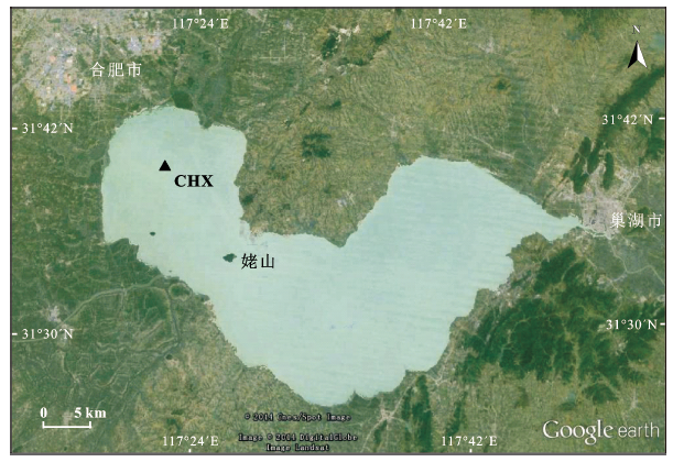
巢湖位于长江中下游段安徽省中部(117°16′54″E~117°51′46″E, 30°25′28″N~31°43′28″N),面积约834 km2,是中国第五大淡水湖。巢湖地处东亚季风的敏感区,属亚热带季风气候,年均气温约15℃,年降水量1 100 mm。湖水主要靠地面径流补给,湖水较浅,平均水深约3 m。流域内30余条河流汇入该湖,再经由唯一的出口河流裕溪河进入长江[9]。以姥山岛为界,湖区分为东巢湖和西巢湖2部分[10]。
于2013年夏季对巢湖进行了野外考察,并使用定制的柱状活塞式采样器在西巢湖深水区采集了沉积柱样(31°35′48.7″N,117°24′37.9″E),编号为CHX(图1)。采样管长1.5 m,内径7 cm,采样点水深3.15 m。柱样带回实验室于-20℃下冷冻保存,在实验室内沿纵向切开,按照1 cm间隔分样,编号自上而下分别记录为CHX-1、CHX-2…CHX-143(数字为取样深度)。沉积剖面20 cm以下样品呈深灰色,表层约20 cm样品为灰黑色,这可能与近年来污染物输入的增加有关。近一个世纪以来,与日俱增的人类活动释放了含营养元素在内的多种污染物,最终导致湖泊生产力增加和沉积物颜色的逐渐加深[11~13]。
图1 研究区域与采样点(图中黑色三角形)(据Google earth修改)
Fig.1 Study area showing sampling site (modified according Google earth)
本研究选取双号样品进行粒度分析,在进行粒度分析以前,对样品进行了前处理。程序如下:将未经研磨的自然风干样品混合均匀,取约0.1 g样品至10 mL离心管,加入10 mL 30% H2O2去除有机质,静置12 h,直到无气泡冒出。将溶液高速离心,去除上清液,然后加入10 mL10% 的HCl去除碳酸盐,静置过夜,直至无气泡产生;继续离心,去除上清液,必要时加入10 mL左右的去离子水,重复上述操作一次。离心之后,加入10 mL 10%的分散剂六偏磷酸钠,超声震荡10 min,以保证样品均匀分散在溶液中。测试仪器为激光粒度仪(Malvern APA2000),测量范围为0.02~2 000 μm,重复测量相对误差<1%。粒级以Krumbein粒度(φ)计,转换公式为φ=-log2(d),式中d为粒级(mm)。
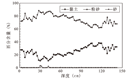
按照Undder-Wentworth标准,将粒度组成分划为黏土(>8 φ)、粉砂(8~4 φ)和砂(<4 φ)3个粒级,图2为CHX沉积柱各粒级组分随深度的变化。由图可知,整个沉积剖面以粉砂为主,黏土次之,几乎不含砂。0~79 cm间的上部样品粉砂和黏土含量范围分别为71.9%~88.4%和10.6%~28.1%,平均含量分别为80.2%±4.5%(n=39)和19.6%±4.8%(n=39),粉砂含量约为黏土的4倍;底部79~143 cm样品中粉砂和黏土含量范围分别为61.7%~78.2%和21.8%~38.3%,平均含量分别为68.6%±4.2%(n=32)和31.4%±4.2%(n=39),粉砂含量约为黏土的2倍。按照Shepard三角定名法,将79 cm以上的沉积样品可分别定名粉砂,该深度以下的样品定名为黏土质粉砂,这与前人对巢湖湖心沉积物的命名(粉砂质黏土)有所不同[7]。CHX沉积柱采自西巢湖深水区,沉积物以粉砂和黏土为主,符合湖泊沉积物粒度自湖岸向湖心砾石、砂、粉砂、黏土的渐变规律。
图2 CHX沉积柱样中黏土、粉砂和砂含量随深度的变化
Fig.2 Changes of grain size compositions throughout the profile CHX
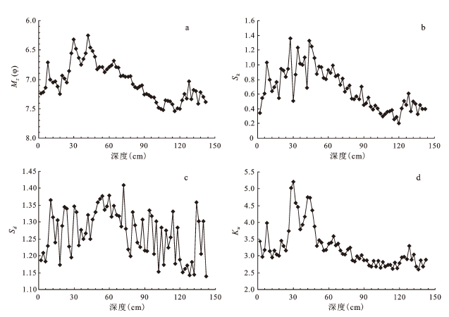
平均粒径(Mz)、标准偏差(Sd)、偏度(Sk)和尖度(Ku)是描述沉积物粒度特征的主要参数,计算这些参数的方法主要有矩法和图解法2种,本文采用矩法[14],结果见图3。
Mz:CHX沉积柱样品Mz值变化范围为7.5~6.2 φ,平均值7.0 φ(n=71,图3a),即湖心沉积物以细粒物质为主。此处Mz值与余铁桥和贾铁飞报道的巢湖湖心沉积物的平均粒径水平接近,且沿深度部面的变化趋势也极为相似[15],但明显低于王心源等报道的湖心沉积物中值粒径,走势也存在较大差别[16],这可能与CHX沉积柱更接近湖心有关。
Sd:CHX沉积柱样品Sd的变化范围为1.14~1.41,平均值1.27(n=71,图3b),属中等到较好程度的分选,反映了较弱的水动力。从分选系数绝对值来看,巢湖沉积物分选性优于黄土、河流、三角洲、滨海和浅海沉积物[17, 18],但比风成沙丘分选性要差[19]。此外,与长江中下游段的一些湖泊沉积物相比[5, 6, 20],巢湖沉积物表现为略好的分选性。
Sk:CHX沉积柱样品Sk变化范围为0.21~1.36,平均值0.67(n=71, 图3c),所有样品的Sk均为正值,说明样品均为正偏态,沉积样品中相对富集粗粒组分。在71个沉积样品中,超过94%的样品Sk >0.3,即绝大多数样品偏态为极正偏。这也在一定程度上反映了巢湖湖心沉积物源相对简单,沉积环境也相对稳定。
Ku:样品尖度值变化范围为2.60~5.22,平均值3.25(n=71,图3d),总体而言峰态为很窄到非常窄。
图3 CHX沉积柱样品Mz (a)、Sd (b)、Sk (c)、Ku (d)参数随深度变化
Fig.3 Vertical distributions of grain size parameters Mz (a), Sd (b), Sk (c), Ku (d) for the profile CHX
统计分析表明,平均粒径与标准偏差、偏度和尖度均显著正相关,相关系数r分别为0.40、0.81和0.92(p<0.01),这意味着水流平均动能的变化会同时影响这些参数。较强的水动力会使粗粒碎屑物质含量明显增加,导致平均粒径变大,同时沉积物变得相对杂乱而使分选性变差,也会导致粗粒组分比例的上升(更正的偏态)和更窄的峰态。
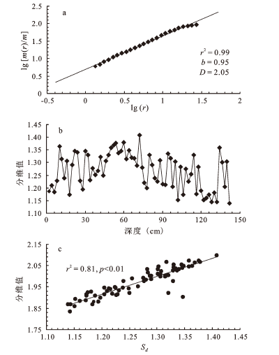
自Mandelbrot在20世纪60年代创立分形理论以来,分形几何被逐渐运用到地质学中,来描述碎形物质(黄土、土壤、沉积物等)的特征。分维值是表示分形的定量指标,该值越大,说明对象的自相似性越高。本文采用广泛使用的幂指数法来计算分维值[21~23],步骤为:①在双对数坐标系(lg-lg)上绘制m(r)/m和r的散点图;② 利用线性回归和最小二乘法,得到拟和直线的斜率b;③ 利用公式D=3-b,计算得到分维值D。
式中m(r)/m为直径小于r的颗粒累积质量m(r)与总质量m的百分比,假设颗粒密度不变,此处以累积体积百分比代替。图4a为典型样品在5%~95%无标度区间内m(r)/m和r的双对数坐标图,二者具有统计意义上的显著相关性;此外,所有样品的线性回归相关系数r>0.95,说明巢湖沉积物具有良好的分形特征(自相似性)。计算得到的分维值D随深度剖面的变化如图4b所示,其值分布在1.83~2.10之间,平均1.97(n=71)。巢湖沉积物的分维值明显偏低于断层泥、冰碛物、黄土、粉尘和阶地沉积[21, 24, 25],即使对于湖泊沉积物,也鲜有分维值<2.0的报道,而CHX沉积柱样分维值的最小值为1.83,平均值也较小,明显低于长江中下游地区太湖和洪泽湖沉积物的分维值[5, 25],这说明巢湖沉积物的复杂程度也相对较低。尽管巢湖沉积物的分维值较小,但仍高于风成沙,这可能与分选程度有关。
相关性分析表明,CHX沉积柱样品的分维值与标准偏差Sd显著正相关(r2=0.81, p<0.01,图4c),即二者存在内在的关联。分维值的大小反映了沉积物的复杂程度,分维值越大,意味着沉积物组成越复杂、结构变得越“混乱”,分选性也就越差。
图4 CHX沉积柱样品分维值计算:样品lg[m(r)/m]-lg(r)关系(CHX-64)(a),分维值计算结果(b),分维值与标准偏差相关性分析(c)
Fig.4 Calculation of fractal dimension: plots of lg[m(r)/m] and lg(r) (CHX-64)(a); results of fractal dimension calculation(b); correlation analysis between fractal dimension and Sd(c)
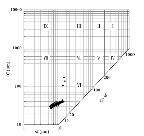
粒度C-M图被广泛用于沉积环境的识别,图5为CHX沉积柱样品粒度组成的C-M图解,C值分布在26.3~169.7 μm (5.2~2.6 φ)之间,平均仅为38.7 μm (4.7 φ);M值范围5.6~14.8 μm (7.5~6.1φ),平均8.9 μm (6.8 φ),这说明最大搬运动能和平均动能都比较低。由图可知,所有样品均位于C-M图左下方VIII区,该区在C-M图中属于远源细粒均质悬浮沉积区,反映相对稳定的低能环境。
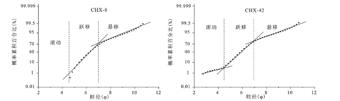
概率累积曲线可以反映沉积物的搬运方式,CHX沉积柱样的概率累积曲线表现为两种类型:两段式(如CHX-8图6)和三段式(如CHX-42,图6)。对于三段式概率累积曲线,3条线段分别反映了滚动、跃移和悬移3种方式,而两段式只存在跃移和悬移两种方式,滚动、跃移、悬移的临界粒径约为4.4 φ和7 φ。3种组分中,跃移组分的比例最高,约为70%,其次为悬移组分,约占25%~30%,滚动组分的比例不足5%。3种搬运方式的相对比例说明巢湖沉积物的搬运方式以悬移和跃移为主,暗示了相对平静的低能沉积环境,这与C-M图解的结果一致。此外,从直线段的斜率可以看出,跃移组分的分选程度要明显高于悬浮组分。
图6 CHX沉积柱代表性样品的概率累积曲线
Fig. 6 Accumulation probability curves for typical CHX samples
粒度分析的原始结果由一个包含了极为复杂信息的矩阵组成,因子分析可以从中提取粒度分布的主控因素,这种方法已被广泛应用在粒度分析中[26, 27]。CHX沉积柱71个样品的粒度测试结果以71×56阶矩阵表示,矩阵中的任一元素以Xij计,代表第i个样品的第j个粒级段。对此矩阵进行了Q型因子分析。
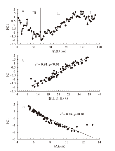
所提取到的第一主因子(PC1)贡献率最大,能够代表原始数据的绝大部分粒度信息,其在每个样品上的载何值见图7a。发现PC1因子与样品中黏土含量显著正相关(图7b),这说明PC1是沉积样品中细粒物质含量的控制因素。根据上文对沉积环境的判断,采样点处于相对稳定的低能环境,在这种情况下,沉积物粒度组成更多地受制于物质在湖泊中的搬运距离。由于细粒物质更易搬运,当搬运距离增加时,水体携带的粗粒物质减少,细粒物质比例上升。因此,PC1因子可作为搬运距离的替代性指标,由于巢湖周边地势平缓,水位波动明显,碎屑物质在湖泊中的搬运距离与水位密切相关。湖泊水位越高,搬运距离越远,因而PC1因子也可以间接指示湖泊水位的变化。PC1与平均粒径Mz的相关性分析进一步证实了,二者显著负相关(图7c)。当湖泊水位上升时,搬运距离增加,采样点处平均粒径也会随之减小,造成了PC1因子和平均粒径的负相关关系。
图7 PC1因子随深度的变化(a)及其与黏土含量(b)和平均粒径Mz(c)的相关性分析
Fig.7 Changes of PC1 with depth (a) and its correlation with clay content (b) and Mz (c)
综上,PC1因子反映碎屑物质在湖泊中的搬运距离,搬运距离越长说明湖泊水位越高,因此PC1因子和Mz可作为巢湖水位的替代性指标,较大的PC1值和较小的Mz值反应高湖泊水位,反之亦然。根据PC1因子在深度剖面上的变化(图7a),巢湖流域的降水和湖泊水位均发生过显著的波动,历史时期巢湖湖泊水位至少可以划分为3个阶段:从143 cm到106 cm(图7a中阶段Ⅰ),PC1值相对较大,但变化幅度较小,说明该时段区域降水维持在相对高的水平,湖泊水位变化不大;自106 cm开始,PC1值持续快速下降,这种下降的趋势一直维持到CHX沉积柱46 cm处(图7a阶段Ⅱ),暗示了湖泊水位在该时期的持续降低;之后,PC1值又在波动中稳步增加(图7a阶段Ⅲ),反映了区域性降水在经历了较长时期的下降后开始逐渐增加,湖泊水位也进一步上升,并持续至今。
通过对西巢湖湖心沉积物粒度组成进行分析,得到如下结论:
1) 沉积物主要由粉砂和黏土组成,且粉砂含量高于黏土;表层样品定名为粉砂,底部样品定名为黏土质粉砂。
2) 沉积物平均粒径较小,为7.0 φ,分选程度中等到较好,正偏态,峰态为很窄到非常窄;沉积物粒度具有分形特征,且分维值与分选程度正相关,分选越差,分维值越高。
3) 沉积环境为低能环境,颗粒搬运方式以跃移和悬移为主;针对粒度组成的Q因子分析表明,PC1因子指示了颗粒在湖泊中的搬运距离和湖泊水位,可进一步用于恢复区域性降水历史。
致 谢:感谢聂亚光、楼创能、江天勇和刘静一在样品采集过程中的帮助,赵晓岚参与了样品前处理,在此一并表示感谢。
The authors have declared that no competing interests exist.
| [1] |
|
| [2] |
South China Sea hydrological changes and Pacific Walker Circulation variations over the last millennium [J].https://doi.org/10.1038/ncomms1297 URL PMID: 3104522 [本文引用: 1] 摘要
The relative importance of north-south migrations of the intertropical convergence zone (ITCZ) versus El Ni帽o-Southern Oscillation and its associated Pacific Walker Circulation (PWC) variability for past hydrological change in the western tropical Pacific is unclear. Here we show that north-south ITCZ migration was not the only mechanism of tropical Pacific hydrologic variability during the last millennium, and that PWC variability profoundly influenced tropical Pacific hydrology. We present hydrological reconstructions from Cattle Pond, Dongdao Island of the South China Sea, where multi-decadal rainfall and downcore grain size variations are correlated to the Southern Oscillation Index during the instrumental era. Our downcore grain size reconstructions indicate that this site received less precipitation during relatively warm periods, AD 1000-1400 and AD 1850-2000, compared with the cool period (AD 1400-1850). Including our new reconstructions in a synthesis of tropical Pacific records results in a spatial pattern of hydrologic variability that implicates the PWC.
|
| [3] |
Holocene East Asian monsoonal precipitation pattern revealed by grain-size distribution of core sediments of Daihai Lake in Inner Mongolia of north-central China [J].https://doi.org/10.1016/j.epsl.2005.02.022 URL 摘要
Two sediment cores recovered in the central part of Daihai Lake in north-central China were analysed at 2- to 4-cm intervals for grain-size distribution. Grain-size distributions of the lake sediments are inferred to be a proxy for past changes in East Asian monsoon precipitation, such that greater silt-size percentage and higher median grain size reflect increased monsoonal precipitation rates. The grain-size record of Daihai Lake sediments spanning the last ca 10,000 yr indicates that the monsoonal precipitation in the lake region can be divided into three stages: the Early, Middle and Late Holocene. During the Early Holocene before ca 7900 cal yr BP, the median grain size (Md) and the silt-fraction content were relatively low and constant, suggesting relatively low precipitation over the lake region. The Middle Holocene between ca 7900 and 3100 cal yr BP was marked by intensified and highly variable monsoonal precipitation, as indicated by high and variable Md values and silt contents of the lake sediments. During this period, average precipitation rate gradually increased from ca 7900 to 6900 cal yr BP, displayed intense oscillations between ca 6900 and 4400 cal yr BP, and exhibited a decreasing trend while fluctuating from ca 4400 to 3100 cal yr BP. Although generally high during the Middle Holocene, both the Md and the silt content assumed distinctly low values at the short intervals of ca 6500–6400, 6000–5900, 5700–5600, 4400–4200 cal yr BP, implying that monsoonal precipitation might have been significantly reduced during these intervals. During the Late Holocene since ca 3100 cal yr BP, grain-size values suggest that precipitation decreased. However, during the Late Holocene, relatively higher Md values and silt contents occurring between ca 1700 to 1000 cal yr BP may denote an intensification of hydrological cycles in the lake area. Changes in the East Asian monsoonal precipitation were not only directly linked with the changing seasonality of solar insolation resulting from progressive changes in the Earth's orbital parameters, but also may have been closely related to variations in the temperature and size of the Western Pacific Warm Pool, in the intensity of the El Nino–Southern Oscillation, and in the path and strength of the North Equatorial Current in the western Pacific.
|
| [4] |
不同时间尺度下的湖泊沉积物环境记录——以沉积物粒度为例 [J].https://doi.org/10.3321/j.issn:1006-9267.2003.06.010 URL [本文引用: 1] 摘要
?在湖泊沉积记录与古气候研究中,沉积物粒度的环境意义常常解释为:粗粒沉积物指示低水位时期的干旱气候,细粒沉积物指示高水位时期的湿润气候.本文通过对云南洱海和程海现代沉积物粒度的研究,揭示了沉积物粒度在不同时间尺度、不同时间分辨率的研究中具有不同的环境指示意义.在长时间尺度、低分辨率(百年、千年)研究中,粗粒沉积物指示湖泊收缩、湖水较浅的干旱气候期;细粒沉积物指示湖泊扩张、湖水较深的湿润气候期.在短时间尺度、高分辨率(年际、10a)研究中,粗粒沉积物指示降雨量较大的湿润年份;细粒沉积物指示降雨量相对较小的干旱年份.由于不同时间尺度研究中沉积分辨率、采样分辨率和定年精度的不同,湖泊沉积物记录所反映的环境信息在不同尺度下因此可能存在差异.在由以往的长时间尺度、低分辨率研究转向短时间尺度、高分辨率研究的过程中,不能简单套用各种指标在长尺度研究中的环境指示意义,必须结合研究的时间尺度和分辨率,综合分析各种因素对环境记录的影响方式和程度,才能得出可靠结论.
|
| [5] |
淮河中下游洪泽湖湖泊沉积物粒度特征及其沉积环境意义 [J].https://doi.org/10.3969/j.issn.1000-0690.2005.05.013 URL [本文引用: 3] 摘要
以淮河中下游洪泽湖湖底沉积物为研究对象,将放射性核素计年与沉积物粒度分析、粒度平面分形研究以及历史文献资料相结合,初步探讨了洪泽湖湖底沉积物粒度特点及该区域近300年来的气候变化,为恢复百年尺度的气候干湿变化提供了一条新途径。研究发现,湖区气候的干湿变化大致可分为三个阶段。进一步说明沉积物粒度参数的变化不仅与自然环境改变有关,也与人类活动如黄河改道、湖泊周围建闸等关系密切。
|
| [6] |
苏州澄湖SC7孔沉积物粒度特征及其古环境意义 [J].
苏州澄湖湖底主要由硬粘土组成,同时残留有湖沼洼地和古河道,古河道大致呈NNW-SSE延伸,与历史文献所载"古三江"之一的东江基本一致.保存着硬粘土平原形成后从河流到湖泊环境演化的良好沉积记录,通过对湖心区古河道SC7孔2cm间隔取样和AMS14C测年、粒度、磁化率等测试分析,初步探讨了该孔的沉积粒度特征及古环境意义,研究结果表明,沉积物粗粉砂含量极少或不含,中-细粉砂和粘土分别占53%-65.8%和19.7%-40.1%;与河床硬粘土相比,粉砂含量较低,粘土含量较高,平均粒径较小,为正偏(硬粘土为极正偏),磁化率也明显较高,多种粒度指标和磁化率指标均表明,澄湖的形成具有河流、河流-湖泊过渡到湖泊的阶段性演化特点,为太湖平原湖荡区湖泊的河泛成因提供了新的证据,现代澄湖则明显受到人类活动的扰动影响.
|
| [7] |
安徽巢湖全新世湖泊沉积物磁化率与粒度组合的变化特征及其环境意义 [J].
通过对获取的巢湖湖泊沉积岩芯的磁化率与粒度组合特征的分析,结合孢粉及相邻其它区域的环境考古资料,得出该岩芯柱样所反映的环境变化信息。结果表明:(1)巢湖湖泊沉积物磁化率曲线在117 cm以下总体上比较平稳而略有下降,117 cm以上人类活动所导致的侵蚀作用加剧使得磁化率值异常升高;(2)本岩芯柱样117 cm以下样品的磁化率强度与粘土的百分比含量呈正相关,而与粉砂组分的百分比含量成负相关;(3)根据磁化率与粒度组合变化特征,结合孢粉分析及全新世以来区域气候变化背景,9 870 Cal a B.P.以来的巢湖流域古气候环境演变可以划分6个不同的时期:9 870~7 000 Cal a B.P.,气候呈温和略干的特点;7 000~4 750 Cal a B.P.,气候温暖湿润;4 750~2 170 Cal a B.P.,流域气候温和干燥,巢湖湖盆局部地区可能出露水面以上;2 170~1 040 Cal a B.P.,气候总体上温和湿润,但是冷暖波动明显;1 040~2 00 Cal a B.P.流域处在温凉稍湿的时期,人类活动逐渐加强;200 Cal a B.P.至今,流域总体上处于相对温暖湿润阶段。
|
| [8] |
全新世巢湖沉积记录及其环境变化意义 [J].https://doi.org/10.3969/j.issn.1000-0690.2006.06.011 URL [本文引用: 1] 摘要
根据巢湖全新世沉积地层对比及对ACN钻孔沉积物的测年、粒度、营养元素含量分析。认为巢湖在全新世中经历了频繁的河流、湖泊交互作用,是一个受河流影响十分显著的沿江湖泊。中全新世以来,巢湖共发生三次显著的湖泊收缩过程,分别是在沉积纪录的5887—5680aB.P.时,其后又再度扩张;2239~2126aB.P.时。是在中国历史时期第二温暖期暖干气候条件下形成的,与其同期的河流相冲积层或淤积粘土,正是巢湖周边战国至汉代古文化遗址的基底物质,之后巢湖再度扩张,甚至导致汉代古城成为水下遗址;1827aB.P.以来,是巢湖现代淤积过程。
|
| [9] |
Distribution and ecotoxicological significance of trace element contamination in a 150 yr record of sediments in Lake Chaohu, Eastern China [J]. |
| [10] |
Environmental changes during early-middle Holocene from the sediment record of the Chaohu Lake, Anhui Province [J]. |
| [11] |
巢湖沉积物δ13Corg和δ15N记录的生态环境演化过程 [J]. |
| [12] |
Distribution and ecotoxicological significance of trace element contamination in a ~150 yr record of sediments in Lake Chaohu, Eastern China. Journal of Environmental Monitoring [J],URL PMID: 3288886407727013343441664292223222221321742810353114037778867153 |
| [13] |
A 100-year sedimentary record of natural and anthropogenic impacts on a shallow eutrophic lake, Lake Chaohu, China. Journal of Environmental Monitoring [J],https://doi.org/10.1039/c1em10760g URL PMID: 22237732 [本文引用: 1] 摘要
In this study, the sediment profiles of total organic carbon, total nitrogen, C/N ratios, total phosphorus, N/P ratios, C/P ratios, particle sizes, and stable carbon and nitrogen isotopes (未13C and 未15N) were used to investigate natural and anthropogenic impacts on Lake Chaohu over the past 100 years. Before 1960, Lake Chaohu experienced low productivity and a relatively steady and low nutrient input. The increasing concentration and fluxes of total organic carbon, total nitrogen, total phosphorus, together with changes in the 未13C and 未15N of organic material in the sediment cores, suggested that the anthropogenic effects on trophic status first started because of an increase in nutrient input caused by a population increase in the drainage area. With the construction of the Chaohu Dam, an increase in the utilization of fertilizer and the population growth which occurred since 1960, stable depositional conditions and increasing nutrient input resulted in a dominantly algae-derived organic matter source and high productivity. Nutrient input increased most significantly around 1980 following the rapidly growing population, with concomitant urbanization, industrial and agricultural development. This study also revealed that the concentration and distribution of nutrients varied between different areas of sediment within Lake Chaohu because of the influence of different drainage basins and pollution sources.
|
| [14] |
Aeolian origin and palaeoclimatic implications of the ‘red clay’ (north China) as evidenced by grain-size distribution [J].https://doi.org/10.1002/1099-1417(200101)16:1<89::AID-JQS578>3.0.CO;2-8 URL [本文引用: 1] 摘要
The Red Clay is an important deposit underlying the Quaternary loess-palaeosol sequence in the Chinese Loess Plateau, being regarded as an excellent record of palaeoclimate changes in the late Tertiary. Several properties of the Red Clay have been measured previously in order to derive climatic information. However, the sedimentary processes involved and the origin of the materials remain controversial. Here we present results of grain-size analyses of the Red Clay from four representative sites in the Chinese Loess Plateau. In particular their grain-size distribution is compared with that of typical Quaternary aeolian loess-palaeosol, as well as lacustrine and fluvial sediments. It appears from the sedimentological evidence that the major part of the Red Clay is of aeolian origin. It is rather similar in some of its properties to the Quaternary loessic palaeosols. The dust forming the Red Clay was transported by a wind system that was weaker than that involved in the accretion of the Quaternary loess. Furthermore, the Red Clay sediment has been modified by post-depositional weathering.
|
| [15] |
巢湖CH-1孔沉积物磁性、粒度特征分析 [J].https://doi.org/10.3969/j.issn.1000-5137.2008.05.014 URL [本文引用: 1] 摘要
通过对巢湖湖心长1.5m的CH-1孔沉积物磁性参数和粒度组成 进行测量,探讨了巢湖的沉积环境变迁.结果表明:CH-1孔沉积物以中粉砂和细粉砂为主,其次为黏土.该孔中黏土粒级对磁性矿物贡献最大.自底部向上,该 孔分为4段:第1段,沉积物向上粒度变细,亚铁磁性矿物含量减少,亚铁磁性矿物颗粒变细;第2段,沉积物向上粒度变粗,亚铁磁性矿物含量减少,磁性矿物颗 粒变细;第3段,沉积物向上粒度变细,亚铁磁性矿物含量增多,磁性矿物颗粒变粗;第4段,沉积物向上粒度变粗,亚铁磁性矿物含量增多,磁性矿物颗粒变粗. 上述结果显示:巢湖湖面在整个沉积历史时期呈现上升和下降的交替变化,反映了气候变化对巢湖沉积的影响.
|
| [16] |
巢湖湖泊沉积记录的早-中全新世环境演化研究 [J].
采用AMS14C对岩芯的年代的精确测定与校正,以及孢粉、粒度等环境代用指标的分析和研究,提取早中全新世环境演变信息,重建了研究区9870~2170aBP(cal)期间的环境演变序列(1)9870~6040aBP(cal)时期,气候在晚更新世干冷向温和干燥发展.在8910aBP(cal)左右,以及6060~6030aBP(cal)时期气候变干冷,湖面有缩小的波动变化现象;(2)6040~4860aBP(cal)时期,气候温和湿润但有波动较大的时段.在5840~5500aBP(cal),本区达到最盛的暖湿期,之后进入5375~4930aBP(cal)的ElmDecline事件期;(3)4860~2170aBP(cal)气候温度、湿度皆下降,是一个温和略干期.3760aBP(cal)出现一次干旱,2170aBP(cal)是巢湖全新世历史上干旱程度较高的一次,巢湖湖盆的局部地区可能出露水面以上.
|
| [17] |
Grain-size features of a Miocene loess-soil sequence at Qinan: Implications on its origin [J].https://doi.org/10.1007/s11430-006-0731-8|ISSN URL [本文引用: 1] 摘要
In this study, grain-size of 507 bulk samples from the QA-I Miocene loess-soil sequence at Qinan were analyzed, and the grain-size features are compared with those of typical Quaternary loess and soil samples, representative lacustrine and fluvial samples. The results indicate that the grain-size distribution pattern of the Miocene loess is essentially similar to that of Quaternary loess, but greatly differs from the lacustrine and fluvial sediments. Loess layers are regularly coarser than soil layers, indicating cyclical climate changes. Median grain-size along the 253.1 m sequence varies from 6 to 13 渭m and the >63 渭m fraction represents only 5.3% in maximum, 0.9% in average. Long-term grain-size variations are consistent with the loess accumulation rate at Qinan and with the eolian mass accumulation rate in the North Pacific. These features firmly indicate an eolian origin of the studied sequence, and also reveal a coeval changes between the long-term changes of eolian grain-size and continental aridity in the dust source regions.
|
| [18] |
Characterizing the depositional settings for sedimentary organic matter distributions in the Lower Yangtze River-East China Sea Shelf System [J].https://doi.org/10.1016/j.ecss.2010.08.001 URL [本文引用: 1] 摘要
Grain-size distributions, total organic carbon (TOC) and total nitrogen (TN) concentrations, and TOC/TN ratios (C/N) were analysed for surface sediments from the Lower Yangtze River-East China Sea (ECS) shelf system. Hierarchical cluster analysis of grain-size parameters (mode, mean, sorting, skewness and kurtosis) has been employed to characterize grain-size compositions. The results suggest there are five grain-size compositional types (type-I-V) that fingerprint distinct depositional conditions. In areas with high sedimentation rates, hydrological sorting preferentially enriches the fraction coarser than 6.4酶 (12 渭m) in shallow seafloor sediments (water depth30 m), and thus forms grain-size compositional type-I (shallow) and type-II (deep). In the open shelf, where modern sediment supply is very limited, grain-size types-III-V are identified according to different winnowing intensity. Overall TOC contents significantly correlate with mud proportions, suggesting muddy sediments are the primary control on OM accumulation. However, de-association of terrestrial OM from fine sediments in the Estuary and the occurrence of presumably relict OM in the open shelf exert additional controls on OM dispersal and carbon cycling in the ECS. By considering geography, oceanography, sediment source, and the relation between sedimentation conditions and sedimentary OM distributions, we define six depositional settings: the lower river, the estuary, the coast, the offshore upwelling area, the erosional area, and the open shelf. These settings describe the sediment dispersal and associated organic matter cycling in the Lower Yangtze River-ECS shelf system.
|
| [19] |
沙坡头地区新月形沙丘粒度特征 [J].
由腾格里沙漠东南缘沙坡头附近新月形沙丘表面沉积物的系统采集分析结果,发现从北部沙漠主体向黄河南岸,沙丘沙平均粒径变细但分选变差。同时,粒径及分选性在沙丘断面出现两种变化模式,其一是沙漠主体新月形沙丘由两侧坡部向丘顶区域粒径变细分选变好;其二为黄河两岸阶地和湖盆滩地的新月形沙丘丘顶沙粒粗于其它部位但分选仍然最好。根据粒度参数间的相互关系和其它环境条件的分析,对沙丘沙粒度变化的原因及偏度等也作了初步探讨。
|
| [20] |
Geochronology of recent lake sediments from Longgan Lake, middle reach of the Yangtze River, influenced by disturbance of human activities [J].https://doi.org/10.1007/s11430-010-3066-4 URL [本文引用: 1] 摘要
The impacts of human activities in Longgan Lake region on the distribution of 210Pb in lake sediment made it difficult to establish geochronological sequence. However, environmental proxies recorded these human activities and could be used as time marker to check 210Pb dating results. Based on the analysis of 210Pbexc distribution in cores LS-1 and LGL-1, and in combination with the human activities records in grain-size and element concentration, the sedimentation rates in the upper layers of these two cores were determined to be 0.19 and 0.23 cm/a respectively. The MAR (mass accumulation rates) of these two cores demonstrated that natural condition, such as precipitation and runoffs, led to the variation of MAR before human disturbance, and human activities controlled the sedimentary processes afterwards, which obviously reduced the particles influx into the lakes. During 1940s when human activity had not changed the water system within the catchment, 210Pb activity was abnormally strong in lakes along middle to lower reaches of the Yangtze River, which might be attributed to less precipitation and can be used as a time marker for geochronological research.
|
| [21] |
一种新的粒度指标:沉积物粒度分维值及其环境意义 [J].https://doi.org/10.3969/j.issn.1000-0550.2003.02.007 URL [本文引用: 2] 摘要
根据分形理论,对1000个不同类型沉积物样品的粒度分形结构及 其分维值作了定量计算.结果表明:各类型沉积物都具有良好的统计自相似性,并且各自有着不同的分维值.粒度分维值的大小与分选好坏密切相关.没有经过外力 搬运与分选的风化破碎物质(碎屑物)--断层泥、冻土的粒度分维值接近于碎形体的分维值2.60左右;经过外力搬运但分选作用较弱的冰碛物、水石流、泥石 流堆积物的粒度分维值也接近2.60;而经过强烈外力分选作用的河床、湖泊沉积物、潮滩及海底沉积物的分维值明显偏小.鉴于此,本文认为分维值可以作为沉 积物类型判别的重要参数之一.
|
| [22] |
Sediment texture and grain-size implications: the Changjiang subaqueous delta [J].https://doi.org/10.1061/41042(349)25 URL |
| [23] |
Influence of microwave and ultrasound on sludge dewaterability [C]. |
| [24] |
不同沉积环境下沉积物的粒度分形特征的对比研究 [J].https://doi.org/10.3321/j.issn:1000-6060.2004.01.009 URL [本文引用: 1] 摘要
通过计算主要来自干旱地区已知成因环境的8组代表性沉积物的分维值,可以发现并不是所有的沉 积物粒度都能获得有实际物理意义的分维值.如塔克拉玛干沙漠风成砂、洛川马兰黄土及塔里木河洪泛平原沉积物的分维值都小于2,使其分维值失去了实际的物理 意义.但是将分维值作为一种沉积物粒度分析参数,失去实际物理意义的分维值仍具有与部分传统粒度参数的相关关系;粒度分维具有明显的区域性特征,不同区域 同种成因类型沉积物的分维值可能相差甚大。将分维值与传统粒度参数进行对比:分维值(D)与平均粒径(Mz,换算成ψ值)可能存在有条件的弱相关关系,但 并不总是前人所说的正比关系;分维值与标准偏差(σ1)则明显呈正比关系。
|
| [25] |
黄海中部海岸末次冰盛期第1硬质黏土层的粒度分维特征及其环境意义 [J].https://doi.org/10.3969/j.issn.1009-2722.2008.10.002 URL [本文引用: 2] 摘要
沉积物粒度分布特征是衡量沉积介质能量,判别沉积环境和水动力条 件的最基本的方法之一,粒度分维是粒度的另外一个重要参数.在前人对硬黏土成因研究的基础上,选取目前具有影响力说法的典型的沉积物:湖泊相、潮滩相、风 成沙、粉尘、洪泛平原、黄土等进行了分维值的计算,通过与小庙洪区钻孔的末次冰盛期第1硬质黏土的粒度分维的对比,初步探索其粒度特征.从粒度分布与分维 的角度进一步印证了该区第1硬质黏土层的沉积环境为河湖相.
|
| [26] |
中晚全新世南极无冰区沉积物的生态环境记录及比较[D] . |
| [27] |
南海晚第四纪陆源沉积: 粒度组成, 动力控制及反映的东亚季风演化 [J].
<p>对南海北部MD05-2904孔、西部MD05-2901孔、南部MD05-2897孔的有孔虫氧同位素进行测定,建立了高分辨率的年代地层。对3个孔的陆源碎屑组分的粒度分布进行了测定和主成分因子分析,结果发现,南海北部陆坡(南部陆坡)的陆源碎屑沉积特征主要受单一的因子Fn(Fs)控制,它可以控制62%(59%)的粒度变化特征。与Fn密切相关的粒度组分为1.52~2.92μm和11.8~27.4μm,与Fs相关的粒度组分为<2.42μm和6.76~14.30μm。南海西部陆坡获得两个主控因子Fw1和Fw2,分别控制46%和32%的粒度变化特征,与Fw1相关的粒度组分为1.26~2.66μm和10.8~14.3μm,与Fw2相关的粒度组分为4.24~7.42μm和30.1~43.7μm。对敏感粒级的变化序列进行分析发现,北部的Fn与海平面升降作用紧密相关,呈现冰期/间冰期旋回尺度的周期性。而南部的Fs呈现高频的岁差周期波动,可能与夏季风演化引起的源区风化、河流搬运等的变化有关。南海西部的陆源沉积物主要来自南海的西南和北部两个地区,分别由东亚夏季风和冬季风驱动的洋流搬运,Fw1和Fw2恰恰代表了这两种动力控制。因此,Fw1和Fw2控制的粒度组成变化间接指示了东亚夏季风和冬季风的演化。研究认为,晚第四纪以来东亚夏季风受控于低纬区的夏季日射量的变化,呈现典型的岁差周期性,而冬季风主要受高纬冰盖变化驱动,呈冰期/间冰期旋回尺度的波动,这反映了东亚季风演化的双重驱动机制。</p>
|

/
| 〈 |
|
〉 |