刘洁 , 许振成
, 许振成
LIU Jie, XU Zhen-cheng
中图分类号: P339
文献标识码: A
文章编号: 1000-0690(2015)04-0483-08
通讯作者:
收稿日期: 2014-02-21
修回日期: 2014-05-8
网络出版日期: 2015-04-20
版权声明: 2015 《地理科学》编辑部 本文是开放获取期刊文献,在以下情况下可以自由使用:学术研究、学术交流、科研教学等,但不允许用于商业目的.
基金资助:
作者简介:
作者简介:刘 洁(1980-),女,江西南昌人,高级工程师,研究方向为流域环境规划与环境管理。E-mail: shuiji_97@163.com
展开
摘要
降雨变化对流域水文过程的影响是地理与环境科学领域关注的热点。应用流域水文模型HSPF建立了东江流域的径流模拟模型,并结合日降雨随机模拟模型,分析了降雨的长期变化对流域径流的影响。结果表明,降雨对东江流域的径流影响显著,径流量随降雨量均值与降雨量变差系数的增减而增减;相同的降雨量均值变化幅度条件下,径流增减的变化幅度相近;降雨量变差系数增加对径流的影响大于降雨量变差系数减小的影响,降雨强度的变化是影响径流量的重要因素,降雨量变化剧烈时,产生的径流更多;在同等的变化幅度内,降雨量均值变化对径流量的影响大于降雨量变差系数;由降雨情景变化引起的月径流的变化在6~8月最为明显。
关键词:
Abstract
The impact of rainfall variation on watershed hydrological process is an issue of great deliberation in geographical and environmental sciences. In this article, a comprehensive watershed model—The hydrological simulation program FORTRAN(HSPF) was set up and calibrated for the Dongjiang River basin in China, and was repeatedly run with various rainfall scenarios generated by the daily rainfall stochastic simulation model. The results indicated that: (1) The runoff changed in the same trend either with rise and fall in mean value or variation coefficient of rainfall; (2) In the four given scenarios (mean value of rainfall has increased by 20% and 40%, decreased by 20% and 40%, respectively), change magnitude of runoff was similar under same change magnitude of mean value of rainfall; (3) The average annual runoff raised by 24.93% when the variation coefficient of rainfall raised by 40%, and raised by 10.84% when the variation coefficient of rainfall raised by 20%. However, it fell by 3.84% and 5.35% respectively when the variation coefficient of rainfall fell by 20% and 40%, which presented that the increase of variation coefficient of rainfall has a greater impact on runoff than the decrease of variation coefficient of rainfall does. The intensity of rainfall change is an important factor affecting the runoff, and heavy rainfall has a great effect on the runoff; (4) Change of runoff due to fluctuation of variation coefficient of rainfall gradually decreased, when variation coefficient of rainfall gradually declined; (5) Average annual runoff raised by 33.99% as mean value of rainfall raised by 20%, and raised by 10.84% as variation coefficient of rainfall raised by 20%, which means change of mean value of rainfall has bigger impact on runoff change than variation coefficient of rainfall; (6) Variation of monthly runoff caused by different rainfall scenarios is more obvious in June, July and August than other months.
Keywords:
气候变化与土地利用变化对流域水文过程的影响是当前地理与环境科学领域关注的热点。在大中尺度流域,降雨对径流过程影响显著[1~5],一方面降雨是流域水资源的最直接来源,降雨过程直接影响水资源的产生和汇聚;另一方面降雨作为水文模型的重要输入之一,必将影响到流域的水资源量计算。气候变化的水文响应研究一般采用两种方式,一种是采用气候模式,另一种则是直接设定不同的气候情景,输入到水文模型中进行模拟。气候模式与水文模型的空间尺度存在着差异性,涉及到气候模式的气象参数预测结果的空间分辨率的降尺度问题;假定不同的气候变化情景,作为水文模型的输入,是近年来相关研究中较常用到的方法,但设定气候变化情景的随意性较大,未结合流域的长期气候特征研究,并且,气候变化情景下气象参数如何降时间尺度,以符合水文模型对气象输入数据的时间分辨率的要求,也是需要解决的问题之一。
因此本文在参考其它研究成果[6~12]的基础上,采用了基于降雨随机模拟模型的情景分析方法。利用国外较成熟的半分布式水文模型HSPF建立了东江流域的产汇流模型,与日降雨随机模拟模型耦合,研究流域径流对降雨变化的响应。HSPF模型在中国的水资源与环境研究领域的应用成果还不多,本文以位于南方湿润地区的中尺度流域—东江流域为例,对该模型在中国南方地区应用的适用性进行了进一步的探讨;同时,基于流域降雨长期变化特征研究的流域日降雨随机模拟模型可生成不同降雨情景下符合流域特征的日降雨数据,与HSPF水文模型耦合,所采用的研究方法可为建立气候变化对中尺度流域水资源长期影响的模拟分析方法提供参考。研究结果可为中国南方湿润地区水资源对气候变化的响应研究以及东江流域的水资源规划与管理提供支持。
东江是珠江流域的主要河流之一,发源于江西省寻乌县桠髻钵,上游称寻乌水,南流入广东境内,至龙川合河坝安远水后称东江。东江干流由东北向西南流,河道长度至石龙为520 km,至狮子洋为562 km,石龙以上流域总面积27 040 km2。
采用的地形数据是由国家基础地理信息中心提供的1:25万的海拔等值线矢量数据栅格化后形成的东江流域地形栅格数据;土壤数据根据1:25万广东土壤类型图对东江流域部分进行矢量化;土地利用/覆被数据来自于两期 Landsat MSS/TM/ETM+ 遥感影像经过校准和解译完成的资料,成像时间分别为 1980 年代初期(1982年、1983年与1984年)和 2000年(1999年、2000年与2001年);气象数据采用1980~2010年降雨、最高最低气温等气象因子日值数据,来源于中国气象数据共享服务网提供的中国地面气候资料日值数据集(位于东江流域及附近的寻乌、连平、东源、惠阳与深圳5个气象站点的降雨与气温数据)和中国地面降水日值0.5°×0.5°格点数据集;博罗水文站径流量数据(1980~2005年)来自广东省水文局。
2.1.1 HSPF模型简介
HSPF模型是由美国环境保护署开发的水文模型,用于较大流域范围内自然和人工条件下的水系中水文水质过程的连续模拟[13~22],可模拟研究气候和土地利用的长期变化对流域水文水质时空变异的影响,适用于空间差异较大的流域的研究,至今已发展到HSPF12.0,并内嵌于美国环保署开发的基于GIS技术的整合式平台BASINS系统中。
2.1.2 数据预处理
1) 气象数据的预处理。
降雨的空间分辨率的变化对径流模拟结果有很重要的影响[13,23~27]。为了降低气象数据的空间分辨率对东江流域水文模型建模的影响,采用中国地面降水日值0.5°×0.5°格点数据集中研究区域的降雨格点数据,作为气象观测站点数据的补充。利用BASIN4.0系统中WDMUtil工具编辑生成模型运行必需的东江流域气象数据的时间序列文件(WDM文件)。
2) 下垫面数据的预处理。
将东江流域土地利用类型划分为7种:耕地、园地、林地、草地、建设用地、水域与未利用地。为了充分考虑流域的空间异质性,利用ArcGIS工具将土地利用数据与土壤分布、坡度数据进行叠置得到新的下垫面类型数据。下垫面类型对应HSPF模型中的水文过程率定参数。
3) 子流域和水文响应单元的划分。
HSPF的空间异质性主要考虑每个离散单元的降雨、土壤类型、土地利用类型等。土壤类型、土地利用类型、坡度的空间异质性通过叠加下垫面类型数据体现,气象数据的空间异质性则通过流域再分割来实现。在子流域划分的基础上,根据气象数据的空间分布,进行水文响应单元的分割处理。东江流域水文响应单元的气象站点分配根据泰森多边形方法进行分割。
2.1.3 模型模拟效果评估的基本方法
采用标准偏差法(Dv)[28]与NASH-Sutcliff相关系数法(ENS)[29]评估模型的模拟效果。理想情况下,模型中的ENS接近于1,Dv接近于0。根据Donigian[30,31]的标准,认为Dv在观测值的10%范围内的模拟已经达到了“非常好”的标准。ENS值在0~1之间,并认为0.9以上为甲等,0.7~0.9为乙等,0.5~0.7为丙等[31]。


式中:
2.1.4 模型率定的基本过程
使用1980~2005年东江流域博罗水文站月平均天然径流量资料进行径流的率定与校验,其中1980~1983年数据用于模型预热,1984~1992年数据用于模型率定,1993~2005年数据用于模型验证。与之对应,1980~1992年的径流模拟过程采用1980年~1992年的气象数据、1980年下垫面数据作为模型的输入数据;1993~2005年的径流模拟过程采用1993~2005年的气象数据、2000年下垫面数据作为模型的输入数据。采用以下基本步骤进行水文过程模拟的参数调整[32]:① 年度总径流量偏差纠正;② 季节总径流量偏差纠正;③ 高流量与低流量部分偏差纠正;④ 流量曲线形状调整。
2.2.1 流域降雨现状变化特征分析
在时间序列趋势分析中,Mann-Kendall检验法是被世界气象组织推荐并被广泛使用的非参数检验方法,该方法不需要样本遵从一定的分布,也不受少数异常值的干扰,适用于水文、气象等非正态分布的时间序列数据的分析。Mann-Kendall检验法的统计分析步骤详见文献[33] [35]。
2.2.2 建立日降雨模拟模型采用的数学方法
1) 随机理论
年降雨序列可看作是天气转化情况和降雨量两者随机遭遇组合而成,经过统计试验法随机选择天气转化情况和降雨量,并将两者的遭遇随机组合在一起,模拟出年降雨序列[6,36]。
2) Pearson-Ⅲ型分布
Pearson-Ⅲ型分布曲线是Pearson曲线族中的一种,较常应用于气象水文频率计算。分布函数参数包括Cv,Cs,
3) 马尔科夫链
马尔科夫概型分析是以时间序列内部概率分布结构为出发点,应用多元时间序列分析和马尔科夫过程的理论从实测时间序列中总结出随机过程的概率规律[37]。
2.2.3 东江流域日降雨模拟模型的建立过程
东江流域内降雨年内变化特征较一致,参考谢平等[6]的研究方法,用泰森多边形面积权重法计算得到的面平均雨量作为研究对象。采用东江流域1986~2010年间的降雨数据进行现状条件下降雨的模拟。
1) 计算有雨转移概率
以每月降雨数据作为统计样本,将1986~2010年多年的降雨系列分为12个样本进行研究。根据马尔科夫链理论,某天的降雨情况只与前一天的降雨情况有关,将每个降雨样本又分为晴天到雨天、雨天到雨天样本,分别计算晴天到雨天、雨天到雨天的转移概率[6]:
上式中,P01表示第i-1天晴天第i天雨天的概率,P11表示第i-1天雨天第i天雨天的概率,D01表示晴天转雨天的天数,D11表示雨天转雨天的天数,D0表示晴天总数,D1表示雨天总数。
2) 生成天气状况
利用一阶马尔科夫有雨转移概率和随机变量的概率分布来模拟生成未来的天气情况。假定降雨概率满足0-1随机均匀分布函数,将随机生成的随机数p与该月的有雨转移概率比较,生成天气状况,重复生成p,依次进行后一天的模拟[6]。
3) 日降雨量的随机模拟
根据随机生成的天气情况,若为晴天,则日降雨量为0,否则为雨天,随机生成一个随机数p,作为降雨量发生的概率。雨日降雨量样本序列符合Pearson-Ⅲ型分布,根据每月雨日降雨量样本序列计算日降雨量分布函数参数(均值
利用日降雨模拟模型生成降雨变化情景下的降雨日值数据序列,建立HSPF模型运行必需的气象数据的WDM时间序列文件。以2000年东江流域下垫面数据、2001~2010年气象数据为基准数据,在降雨变化情景模拟的基础上,应用构建的东江流域HSPF水文模型模拟径流过程,分析降雨变化对流域径流的影响。
月径流过程在模型校正期和验证期都取得了较好的模拟精度(表1,图1~图3)。在径流校正和验证中Dv分别为0.53%和5%,小于10%;ENS分别为0.93和0.89(大于0.7)。
表1 博罗站径流模拟结果
Table 1 The simulation results of runoff at Boluo hydrologic station
| 时段 | 年均径流量观测值(104m3) | 年均径流量模拟值(104m3) | Dv(%) | ENS |
|---|---|---|---|---|
| 校正期(1984~1992年) | 2.227E+06 | 2.239E+06 | 0.527 | 0.926 |
| 验证期(1993~2005年) | 2.368E+06 | 2.250E+06 | 4.996 | 0.894 |
图1 1980~1992年博罗水文站径流模拟校准结果(a)与相关分析(b)
Fig.1 Runoff simulation calibration results (a) and correlation analysis(b) at Boluo hydrologic station in 1980-1992
图2 1993~2005年博罗水文站径流模拟验证结果(a)与相关分析(b)
Fig. 2 Runoff simulation validation results (a) and correlation analysis (b) at Boluo hydrologic station in 1993-2005
图3 博罗水文站1984~1992年(a)与1993~2005年(b)多年平均月径流过程
Fig.3 Average monthly runoff process in 1984-1992(a) and in 1993-2005(b)at Boluo hydrologic station
1980~2010年东江流域寻乌、连平、东源、深圳这4个气象站点的年降雨量呈下降趋势,只有惠阳站呈略上升趋势(表2)。显著性检验结果表明:除东源站数据通过了90%的显著性检验外,其它4个站点的年降雨量变化趋势不明显。利用Mann—Kendall突变检验分析东江流域年降雨量的变化特征,结果显示:寻乌、东源和深圳站年降雨量变化在1984年左右可能存在突变。寻乌站突变点在1983年和1983年开始寻乌站降水量有下降趋势;东源站突变点在1985年,从1985年开始东源降水量有减少趋势;深圳站突变点也在1983年,从1983年开始深圳降水量出现减少趋势,从1994年开始降雨量有小幅上升趋势。使用Mann-Kendall检验方法进一步统计分析东江流域月降雨量的年际变化特征,结果表明,总体上东江流域5个站点的月降水量的年际变化特征较为一致。
表2 东江流域年降雨量的Mann-Kendall检验值
Table 2 Mann-Kendall test value of annual and seasonal rainfall at representative stations in the Dongjiang River Basin
| 时间 | 寻 乌 | 连平 | 东源 | 惠阳 | 深圳 |
|---|---|---|---|---|---|
| 全年 | -0.442 | -0.714 | -1.428* | 0.204 | -0.068 |
| 春 | -2.176** | -1.632* | -2.55*** | -1.428* | -0.85 |
| 夏 | 2.108** | 2.312** | 0.799 | 1.564* | 0.748 |
| 秋 | -1.326* | -0.408 | -0.969 | 0.136 | -0.204 |
| 冬 | -0.272 | -0.476 | -0.238 | -0.102 | -0.136 |
在降雨现状特征分析的基础上建立东江流域的日降雨随机模拟模型。东江流域1986~2010年有雨转移概率计算结果见表3;日降雨随机模拟结果如表4所示,模拟结果显示各月降雨天数与实测资料最大相差2 d,全年相差13 d,各月模拟值与实测值月均降雨量相对误差都在15%以内,相对误差的绝对值最小0.33%,最大14.1%。降雨模拟序列与实测序列较吻合,模拟结果具有良好的精度,基于马尔科夫链与Pearson-Ⅲ型分布的日降雨随机模拟模型适合应用在东江流域的降雨变化的情景模拟及其所带来的影响的分析中。
表3 东江流域1986~2010年有雨转移概率计算结果
Table 3 Monthly probability of rainy day transition in the Dongjiang River Basin in 1986-2010
| 月份 | 晴天到雨天 | 雨天到雨天 |
|---|---|---|
| 1 | 0.2034 | 0.6711 |
| 2 | 0.3100 | 0.7427 |
| 3 | 0.3859 | 0.8333 |
| 4 | 0.4400 | 0.8400 |
| 5 | 0.4489 | 0.8664 |
| 6 | 0.5905 | 0.9116 |
| 7 | 0.4578 | 0.8736 |
| 8 | 0.6028 | 0.8596 |
| 9 | 0.3651 | 0.8112 |
| 10 | 0.1572 | 0.6579 |
| 11 | 0.1515 | 0.6577 |
| 12 | 0.1387 | 0.6545 |
表4 日降雨随机模拟结果(1986~2010年多年平均)
Table 4 Results of daily rainfall stochastic simulation of every month (average of years 1986-2010)
| 月份 | 实测月均降雨天数 (d) | 模拟月均降雨天数 (d) | 相差天数 (d) | 实测月均降雨量 (mm) | 模拟月均降雨量 (mm) | 绝对差值 (mm) | 相对误差 (%) |
|---|---|---|---|---|---|---|---|
| 1 | 11 | 12 | 1 | 48.23 | 46.02 | -2.20 | -4.57 |
| 2 | 15 | 14 | -1 | 76.28 | 73.91 | -2.37 | -3.11 |
| 3 | 21 | 20 | -1 | 139.01 | 119.41 | -19.60 | -14.10 |
| 4 | 22 | 20 | -2 | 209.12 | 181.49 | -27.63 | -13.21 |
| 5 | 23 | 22 | -1 | 246.21 | 236.07 | -10.14 | -4.12 |
| 6 | 26 | 24 | -2 | 344.98 | 343.76 | -1.22 | -0.35 |
| 7 | 24 | 23 | -1 | 221.93 | 222.67 | 0.74 | 0.33 |
| 8 | 25 | 24 | -1 | 229.39 | 217.55 | -11.84 | -5.16 |
| 9 | 19 | 18 | -1 | 147.19 | 141.03 | -6.15 | -4.18 |
| 10 | 10 | 8 | -2 | 39.18 | 40.98 | 1.80 | 4.59 |
| 11 | 9 | 7 | -2 | 32.90 | 36.96 | 4.05 | 12.32 |
| 12 | 8 | 8 | 0 | 39.84 | 38.44 | -1.41 | -3.53 |
| 合计 | 213 | 200 | -13 | 1774.28 | 1698.3 | -75.97 | -4.28 |
3.3.1 对年径流的影响
各降雨情景下,年径流的变化情况如表5和表6所示。情景一:降雨量均值
表5 降雨均值变化情景下的年径流模拟结果
Table 5 Simulated rate of annual runoff variation under different mean value of rainfall
| 情景一 | 情景二 | 情景三 | 情景四 | |
|---|---|---|---|---|
| 年均径流量 变化率(%) | 68.90 | 33.99 | -32.60 | -63.02 |
表6 降雨量Cv变化情景下的年径流模拟结果
Table 6 Simulated rate of annual runoff variation under different variation coefficient of rainfall
| 情景五 | 情景六 | 情景七 | 情景八 | |
|---|---|---|---|---|
| 年均径流量 变化率(%) | 24.93 | 10.84 | -3.84 | -5.35 |
基于日降雨量随机模拟模型和东江流域HSPF水文模型的模拟结果显示在其它条件不变时,当降雨量均值增加20%时,年均径流总量增加33.99%,当降雨量均值减小20%时,年均径流总量减少32.60%,降雨对径流的影响显著;在其它条件不变时,年径流量随着降雨均值的增加而增加,随降雨均值的减小而减小;在降雨量均值20%的变化范围内,东江流域年径流量增减的幅度相近,降雨量均值增加40%所带来的径流的增加幅度稍大于降雨量均值减小40%所带来的径流的减小幅度。
降雨量变差系数的情景模拟结果表明,年径流量随降雨量变差系数值的增加而增加,随降雨量变差系数值的减小而减小;降雨量变差系数值表明降雨量的变化程度,模拟结果表明,降雨量变差系数值增加对年径流的影响大于变差系数减小的影响;随着降雨量变差系数值的减小,年均径流量的变化幅度逐渐减小;基于日降雨量随机模拟模型和东江流域HSPF水文模型的模拟结果显示在其它条件不变时,当降雨量变差系数值增加20%时,年均径流总量增加10.84%,当降雨量变差系数值减小20%时,年均径流总量减少3.84%,当降雨量变化剧烈时,产生的径流更多。
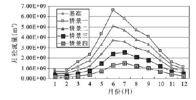
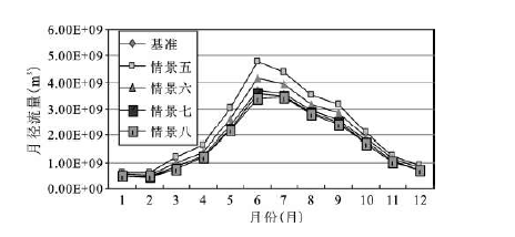
3.3.2 对月径流的影响
各降雨情景下,月径流的变化情况如图4和图5所示。月径流量随降雨量均值的增加而增加,随降雨量均值的减小而减少;随降雨量变差系数的增加而增加,随降雨量变差系数的减小而减少;降雨均值变化对月径流的影响大于降雨量变差系数的影响。
图4 降雨均值变化情景下的多年平均月径流模拟结果(博罗)
Fig.4 Simulated average monthly runoff under different mean value of rainfall at Boluo hydrologic station
图5 降雨Cv变化情景下的多年平均月径流模拟结果(博罗)
Fig.5 Simulated average monthly runoff under different variation coefficient of rainfall at Boluo hydrologic station
与年径流的变化情况相似,当降雨均值增大与减小的幅度一样时,月径流的变化幅度相近;降雨量变差系数增大对月径流量的影响大于降雨量变差系数减小的影响,仍然体现了降雨量的不均匀对径流量的影响,降雨量的不均匀变化程度的加大会造成径流量的增加,体现了大暴雨对径流量的影响。
从径流量的月分布变化来看,降雨量均值与降雨量变差系数的变化对月径流的影响在丰水期明显大于枯水期,由降雨情景变化引起的月径流的变化在6~8月最为明显。
从东江流域不同降雨情景的年径流量和月径流量的变化分析可知,降雨对东江流域的径流影响显著。径流量随降雨量均值的增减而增减,随降雨量变差系数的增减而增减;在设定的变化情景下,相同的降雨量均值变化幅度条件下,径流的增减量的变化幅度相近,降雨量变差系数增加对径流的影响大于降雨量变差系数减小的影响,说明降雨强度的变化也是影响径流量的重要因素,大暴雨对径流量的影响较大;在同等的变化幅度内,降雨量均值变化对径流量的影响大于降雨量变差系数;随着降雨量变差系数的逐渐减小,所带来的径流量的变化幅度逐渐减小;由降雨情景变化引起的月径流的变化在6~8月最为明显。
The authors have declared that no competing interests exist.
| [1] |
气候与土地利用变化对水文水资源的影响研究 [J].https://doi.org/10.3321/j.issn:1001-8166.2001.03.021 URL Magsci [本文引用: 1] 摘要
<p>水资源短缺和水患灾害已成为全球关心的重大问题。气候与土地利用变化对流域水资源和旱涝的影响以及由此产生的社会经济后果已引起人类社会的广泛关注。深入综合地开展这方面的研究对国民经济建设和可持续发展规划决策有重要的意义。通过分析总结已进行的有关研究工作,对该领域的研究进展作了简要回顾,讨论了现有工作的不足和今后的研究内容和方法。</p>
|
| [2] |
The impact of decadal fluctuations in mean precipitation and temperature on runoff: sensitivity study over the United States [J].
|
| [3] |
Climatic variation and surfacewater resources in the Great Basin Region [J]. |
| [4] |
Recent hydro-climatic fluctuations and their effects on water resources in Illinois [J]. |
| [5] |
Detection of changes in streamflow and floods resulting from climate fluctuations and landuse-drainage changes [J]. |
| [6] |
|
| [7] |
气候变化对海河流域水文特性的影响 [J].https://doi.org/10.3321/j.issn:0559-9350.2005.03.003 URL 摘要
本文应用大尺度陆面水文模型--可变下渗能力模型VIC(Variable Infiltration Capacity)与区域气候变化影响研究模型PRECIS(Providing Regional Climate for Impacts Studies)耦合,对气候变化情景下海河流域水资源的变化趋势进行预测.结果表明:未来气候情景下,即使海河流域降水量增加,年平均径流量仍将可能减少,预示海河流域的水资源将十分短缺;若考虑21世纪人口增长因素,海河流域的水资源形势将更加严峻;未来气候情景下,汛期的径流量增加,说明海河流域发生洪水的可能性将增大.
|
| [8] |
与MM5气象模式耦合的VIC分布式水文模型构建 [J].https://doi.org/10.3969/j.issn.1001-4179.2008.08.032 URL 摘要
从水文气象耦合的角度入手,根 据汉中流域的特点,首次在汉江流域MM5运行的9 km×9 km网格上构建了VIC日分布式水文模型。利用流域内7个水文站的径流资料对该模型进行了应用检验。结果表明,该模型能较好模拟汉中流域的日径流过程,其 模拟精度与集总式VIC模型和集总式三水源新安江模型基本相当,但它充分考虑了研究流域内降水输入和下垫面条件的空间差异性,能够提供网格降水分布及流域 内产汇流的分布状况,能进一步同中尺度MM5气象模式耦合,延长洪水预报的预见期。
|
| [9] |
基于SWAT模型的汉江流域水资源对气候变化的响应 [J].
<p>汉江流域未来的气候变化趋势和对水资源的影响,将直接关系到南水北调工程和引江济汉工程的使用和效益。因此,分析研究汉江流域水资源对气候变化的响应特点,可为地面调水、空中水资源开发、应对气候变化的不利影响和更好地保护南水北调中线水源区的水资源提供科学依据。以1971~2000年为基准期,应用SWAT模型对汉江流域基准期内的逐月径流进行了模拟;在30 a基准期径流模拟的基础上,以全球变化背景下可能出现的25种不同气候变化模式为假设条件,模拟出各假设气候变化模式下汉江流域水资源状况,获得了各气候变化模式下汉江流域水资源相对于基准期的变化率,研究了汉江流域水资源对气候变化的响应程度。结果表明:模型模拟精度高于评价标准(〖WTBX〗Ens>05,r2>06〖WTBZ〗),SWAT模型适用于汉江流域的径流模拟;不同气候变化情景下,汉江流域径流变化较实际蒸散发的变化明显;降水对地表径流、基流的影响要大于气温;气温对实际蒸散发的影响大于降水;降水增加或气温降低都会导致径流增加,而降水增加或气温增加都会导致实际蒸散发的增加.</p>
|
| [10] |
土地利用变化和气候波动对东江流域水循环的影响 [J].
研究土地利用变化和气候波动对东江流域水资源及水循环的影响,将为东江流域国民经济的可持续性发展、水资源的有效利用和调配等提供决策依据.以SCS模型为基础,建立适用于东江流域的月水量平衡模型,并利用8个代表流域的资料进行检验,模型结构简单,模拟结果说明所建模型具有较高的模拟精度.
|
| [11] |
Hydrological modeling fo Seydi Suyu watershed(Turkey) with HSPF [J]. |
| [12] |
Predicting plausible impacts of sets of climate and land use change scenarios on water resources [J].https://doi.org/10.1016/j.apgeog.2011.06.014 URL [本文引用: 1] 摘要
The Hydrologic Simulation Program 鈥 Fortran (HSPF) model was chosen in this study to simulate stream flow and nutrient transport process. Five hypothetical climate change scenarios were used to cover the possible ranges of variability in the year 2050. An enhanced population-coupled Markov-Cellular Automata (CA-Markov) land use model was developed to predict the 2050 land use pattern. When these scenarios were incorporated into the HSPF model, the future conditions in the LMR basin were postulated. The findings demonstrated that: 1) the LMR watershed would experience an increase in flow and nutrients under the 2050 land use projection, 2) stream flow and water quality impacts would be amplified when both climate and land use changes were simultaneously considered, 3) land use change (and in the case of the LMR watershed, urbanization) could help to alleviate water shortage during the dry years, 4) total phosphorus and nitrogen would increase under all future climate and land use scenarios; the highest increase was found under the combined wettest and future land use scenarios, and 5) the described approach is effective in simulating the hydrologic and water quality effects of climate and land use changes in a basin scale. These results are relevant to planners; they can be useful in formulating realistic watershed management policies and mitigation measures.
|
| [13] |
|
| [14] |
Calibration of the HSPF model with a new coupled FTABLE generation method [J].https://doi.org/10.1016/j.pnsc.2009.07.006 URL |
| [15] |
A S,et al. Development of the HSPF-Paddy model to estimate watershed pollutant loads in paddy farming regions [J].https://doi.org/10.1016/j.agwat.2007.02.006 URL 摘要
The Hydrological Simulation Program-FORTRAN (HSPF) was modified to simulate watershed pollutant loads in paddy farming regions. Dike height and the Dirac delta function were added to a modified HSPF code (HSPF-Paddy) to incorporate the behavior of ponded water and nutrients in rice paddy fields. HSPF-Paddy was validated by examining its application to a rice paddy plot (3000聽m 2 ) and a watershed (1803聽km 2 ) that contained a significant proportion of rice paddy fields (30%). The model efficiency at the plot scale was very high showing 0.52, 0.93, and 0.93 for ponded water depth, and accumulation of total nitrogen, and total phosphorus, respectively, and simulated values and observed data were in close agreement. Model efficiency was somewhat lower at the watershed scale showing 0.82, 0.78, 0.44, 0.61, and 0.63 for stream flow, temperature, 5-day biochemical oxygen demand, total nitrogen, and total phosphorus, respectively. However, model performance was generally within expectations, and generally model efficiency greater than 0.5 is deemed acceptable considering the complexity of the watershed in terms of size and land use. This comprehensive, dynamic model is applicable to a wide range of scales, from plot to watershed, and can be used to simulate various paddy field and watershed environmental conditions, including loads from point and nonpoint source pollution. It may be a practical alternative to the unit-load method for estimates of watershed pollution loads, especially in paddy farming regions, where nonpoint source pollution loads may be poorly estimated because of highly site-specific conditions. The application of HSPF-Paddy is recommended for watershed management and best management practices (BMPs) evaluation in paddy farming regions.
|
| [16] |
A correction of DIN uptake simulation by Michaelis-Menton saturation kinetics in HSPF watershed model to improve DIN export simulation [J].https://doi.org/10.1016/j.envsoft.2004.09.025 URL 摘要
Plant uptake of dissolved inorganic nitrogen (DIN) has a major effect on the watershed export of DIN. Plant uptake depends on soil moisture. The literature describes plant uptake under two conditions. One condition, when moisture is deficient, increasing moisture may increase nitrogen (N) uptake (in mass per unit time). The other condition, when moisture is sufficient, i.e., at or above the field capacity, increasing it may dilute the solution and decrease N uptake. The two different observed relationships of moisture and uptake cannot be simply simulated by the Michaelis鈥揗enton saturation kinetics under the current setting in the Hydrological Simulation Program 鈥 Fortran (HSPF) software. This paper first compares two methods of simulated plant N uptake. The current HSPF (Version 11) uses concentration (per unit time) as the unit of uptake rate for the entire range of moisture conditions, which is inappropriate for moisture-sufficient conditions and results in higher uptake and lower DIN export during higher flow days. An alternative method uses mass (per unit area per unit time) as the unit of uptake rate, resulting in a better DIN load-flow relationship. However, it overestimates uptake in moisture-deficient conditions. This paper presents an integral method, which simply combines the above two mechanisms to simulate plant uptake in different moisture saturation conditions to improve load-flow relationships. However, it is not optimal in the operation of HSPF. Ultimately, a synthetic method, which is operational through HSPF code modification, is introduced. The synthetic method results in a better relationship between moisture and uptake, and provides reliable exports of DIN under a range of hydrology conditions.
|
| [17] |
Coupling of hydrologic and hydraulic models for the Illinois River Basin [J].https://doi.org/10.1016/j.jhydrol.2007.08.004 URL 摘要
SummaryThe Hydrologic Simulation Program - Fortran (HSPF) was applied to the Illinois River Basin using the U.S. Environmental Protection Agency's (USEPA) Better Assessment Science Integrating Point and Nonpoint Sources (BASINS) system. Values of the HSPF model parameters were based on the calibrations of three representative watersheds within the basin. Over the 1985-1995 simulation period, monthly and annual mass balances correlated well with observed discharges at three gaging stations along the Illinois River. However, poor correlation of daily flows was due largely to the weakness of the HSPF model in routing dynamic flows through the complicated Illinois River system. To address this problem, a one-dimensional unsteady state flow model (UNET) developed for the main stem of the Illinois River was coupled with the HSPF model to perform the flow routing. Comparison of hydrographs showed much closer correlation between coupled HSPF-UNET model simulations of daily flows and observed flow hydrographs. This study also showed that peak flows simulated by the HSPF model occurred several days before the actual observations. However, the coupled HSPF-UNET model simulated peak flow time more closely to the observations. The Nash-Sutcliffe efficiency (NSE) computed using observed and simulated daily flows from HSPF and HSPF-UNET models was 0.72 and 0.79 at Marseilles, 0.63 and 0.82 at Kingston Mines, and 0.40 and 0.85 at Valley City, respectively. As expected, the NSE computed using mean monthly flows was also slightly better from HSPF-UNET than from HSPF, but the annual NSE values were nearly same from both models.
|
| [18] |
Land-use effects on fluxes of suspended sediment, nitrogen and phosphorus from a river catchment of the Great Barrier Reef, Australia [J].https://doi.org/10.1016/j.jhydrol.2008.04.003 URL 摘要
SummaryA 6-year study was conducted in the Johnstone River system in the wet tropics of north-eastern Australia, to address concerns that the Great Barrier Reef is at risk from elevated levels of suspended sediment (SS) and nutrients discharged from its river catchments. Aims were to quantify: (i) fluxes of SS, phosphorus (P) and nitrogen (N) exported annually from the catchment and (ii) the influence of rural land uses on these fluxes. Around 55% of the 1602 kmcatchment was native rainforest, with the reminder developed mainly for livestock and crop production. Water quality and stream flow were monitored at 16 sites, with the emphasis on sampling major runoff events. Monitoring data were used to calibrate a water quality model for the catchment (HSPF), which was run with 39 years of historical precipitation and evaporation data. Modelled specific fluxes from the catchment of 1.2 卤 1.1 t SS hay, 2.2 卤 1.8 kg P hayand 11.4 卤 7.3 kg N haywere highly variable between and within years. Fluxes of SS and P were strongly dominated by major events, with 91% of SS and 84% of P exported during the highest 10% of daily flows. On average, sediment P comprised 81% of the total P flux. The N flux was less strongly dominated by major events and sediment N comprised 46% of total N exports. Specific fluxes of SS, N and P from areas receiving precipitation of 3545 mm ywere around 3-4 times those from areas receiving 1673 mm y. For a given mean annual precipitation, specific fluxes of SS and P from beef pastures, dairy pastures and unsewered residential areas were similar to those from rainforest, while fluxes from areas of sugar cane and bananas were 3-4 times higher. Specific fluxes of N from areas with an annual precipitation of 3545 mm ranged from 8.9 卤 6.5 kg N hay(rainforest) to 72 卤 50 kg N hay(unsewered residential). Aggregated across the entire catchment, disproportionately large fluxes of SS, total P and total N were derived from areas of sugar cane and banana production. Fluxes of nitrate N comprised 32% of mean annual total N flux and were disproportionately high from unsewered residential areas and from areas used for sugar cane and banana production. Notably, 60% of the total catchment flux of nitrate came from areas of sugar cane, which comprised only 12% of the total land area. Modelled scenarios suggest contemporary nitrate fluxes were nearly six times those under natural conditions (pre-development), a much greater increase than estimated for SS, total P and total N. These elevated nitrate fluxes are of particular concern for the protection of aquatic ecosystems, since nitrate is a readily bio-available form of N. Results of the study suggest management practices associated with certain land uses may need further investigation and improvement. To reduce nitrate fluxes, this includes a need to address fertiliser management in the sugar cane and banana industries and wastewater disposal practices in unsewered residential areas.
|
| [19] |
Isolating the water quality responses of multiple land uses from stream monitoring data through model calibration [J].https://doi.org/10.1016/j.jhydrol.2009.09.004 URL 摘要
SummaryQuantifying relationships between stream water quality and catchment land uses is a major goal of many water quality monitoring programs. This is a challenging task that is rarely achieved through simple analysis of raw data alone. Multiple regression analysis provides one approach, which despite significant limitations, can be successful when very large data sets are available and only annual estimates are required. However, regression techniques have limited application to sub-annual data sets. We present a new method for isolating the water quality responses of different land uses from monitoring data through hydrological model calibration, using a process of simultaneous calibration at several monitoring sites. In addition to model parameters, model algorithm complexity and the number of land-attribute groups are also used as calibration 'parameters'. This helps increase model parameter uniqueness and model predictive certainty. We applied the technique to water quality data from the Johnstone River catchment (1602 km ) in north-east Australia, using the HSPF model. The data comprised >4000 samples from over five years of monitoring at 16 sites, which drained sub-catchments of differing land area and proportions of each land use. Monitoring occurred at flow gauging sites during high stream flows, and regularly at all sites during non-event periods. Variables modelled included discharge, suspended sediment, and various forms of nitrogen and phosphorus. The calibration process aimed to maximise both goodness-of-fit and parameter sensitivity. We achieved a substantial simplification of HSPF algorithms without appreciable reduction in goodness-of-fit, by a combination of: fixing parameters, tying parameters, and introducing new, simpler equations. Two key calibration tools were reducing the number of land-use groups (by combining land uses) and tying parameters between the three flow paths modelled (surface flow, interflow and base flow). These in turn removed insensitive parameters, increased the sensitivity of remaining parameters, and increased model predictive power. For calibration of suspended sediment, we found our conceptual model was too complex for the information content of the data, so it was necessary to group certain land uses and simplify algorithms in HSPF. In contrast, for nitrate, our conceptual model was too simple, with successful calibration requiring a finer resolution of land use in the catchment. A major advantage of our technique is that it can isolate land-use effects from stream monitoring data on a modelling time step that is unachievable by regression analysis, with a sensitivity that enables detection of relatively small differences in time and/or space. The technique also enhances confidence in estimates, it identifies 'sensitive' and 'insensitive' parameters and processes, and it provides a robust calibration by reducing the parameter solution space. Further, by using a hydrological model the technique can account for spatial and temporal variation in land use and rainfall. It is also predictive, so it can be used to assess impacts of land-use-change scenarios within the catchment. Additionally, it can provide insights into the type and amount of data required to isolate land-use effects on different water quality parameters, which can be used to enhance the effectiveness and cost-efficiency of the monitoring program design.
|
| [20] |
A simulation-based interval two-stage stochastic model for agricultural nonpoint source pollution control through land retirement [J].https://doi.org/10.1016/j.scitotenv.2005.09.053 URL PMID: 16242757 摘要
ABSTRACT This study presents a simulation-based interval two-stage stochastic programming (SITSP) model for agricultural non-point source (NPS) pollution control through land retirement under uncertain conditions. The modeling framework was established by the development of an interval two-stage stochastic program, with its random parameters being provided by the statistical analysis of the simulation outcomes of a distributed water quality approach. The developed model can deal with the tradeoff between agricultural revenue and "off-site" water quality concern under random effluent discharge for a land retirement scheme through minimizing the expected value of long-term total economic and environmental cost. In addition, the uncertainties presented as interval numbers in the agriculture-water system can be effectively quantified with the interval programming. By subdividing the whole agricultural watershed into different zones, the most pollution-related sensitive cropland can be identified and an optimal land retirement scheme can be obtained through the modeling approach. The developed method was applied to the Swift Current Creek watershed in Canada for soil erosion control through land retirement. The Hydrological Simulation Program-FORTRAN (HSPF) was used to simulate the sediment information for this case study. Obtained results indicate that the total economic and environmental cost of the entire agriculture-water system can be limited within an interval value for the optimal land retirement schemes. Meanwhile, a best and worst land retirement scheme was obtained for the study watershed under various uncertainties.
|
| [21] |
Development of integrated watershed management schemes for an intensively urbanized region in Korea [J].https://doi.org/10.1016/j.jher.2007.07.004 URL 摘要
A systematic, seven-step approach to integrated watershed management for sustainability was proposed and applied to upstream watershed of the Anyangcheon in Korea, which experiences streamflow depletion, frequent flood damages, and poor water quality due to rapid urbanization. To understand watershed components and processes, static and dynamic data were collected and synthetic hydrologic cycles generated by HSPF (Hydrologic Simulation Program – FORTRAN) were simulated (STEP 1). To identify and quantify problems within the watershed, three indices (following the pressure–state–response model) were employed: Potential Flood Damage (PFD), Potential Streamflow Depletion (PSD), and Potential Water Quality Deterioration (PWQD). Composite programming, a method of multi-criteria decision-making, was employed to estimate all indices and analytic hierarchy process are introduced to quantify the weighting values of all indicators (STEP 2). The primary goal of managers is to maintain certain minimum levels of water for instreamflow requirement and total maximum daily load (TMDL). Therefore target water quality and, instreamflow requirements (including low flow and fish flow) were specifically set (STEP 3). All possible management alternatives were listed (STEP 4) and a few specific management options which are technically, economically, and environmentally feasible, were selected (STEP 5). The ability of each feasible option to achieve the desired water quantity and quality criteria was analyzed and quantified using the HSPF (STEP 6). Finally, an evaluation index was calculated using each of the proposed alternatives in order to rank the sustainability and priority of alternatives (STEP 7).
|
| [22] |
Assessing the hydrologic performance of the EPA’s nonpoint source water quality assessment decision support tool using North American Land Data Assimilation System (NLDAS) products [J]. |
| [23] |
|
| [24] |
Effect of rainoff variability on streamflow simulation [J].
|
| [25] |
Storm runoff simulation using radar-estimated rainfall rates and a unit hydrograph model(SYN-HYD) applied to the Greve watershed [
|
| [26] |
Influence of rainfall spatial variability on flood prediction [J].https://doi.org/10.1016/S0022-1694(01)00611-4 URL 摘要
This paper deals with the sensitivity of distributed hydrological models to different patterns that account for the spatial distribution of rainfall: spatially averaged rainfall or rainfall field. The rainfall data come from a dense network of recording rain gauges that cover approximately 2000km 2 around Mexico City. The reference rain sample accounts for the 50 most significant events, whose mean duration is about 10h and maximal point depth 170mm. Three models were tested using different runoff production models: storm-runoff coefficient, complete or partial interception. These models were then applied to four fictitious homogeneous basins, whose sizes range from 20 to 1500km 2 . For each test, the sensitivity of the model is expressed as the relative differences between the empirical distribution of the peak flows (and runoff volumes), calculated according to the two patterns of rainfall input: uniform or non-uniform. Differences in flows range from 10 to 80%, depending on the type of runoff production model used, the size of the basin and the return period of the event. The differences are generally moderate for extreme events. In the local context, this means that uniform design rainfall combining point rainfall distribution and the probabilistic concept of the areal reduction factor could be sufficient to estimate major flood probability. Differences are more significant for more frequent events. This can generate problems in calibrating the hydrological model when spatial rainfall localization is not taken into account: a bias in the estimation of parameters makes their physical interpretation difficult and leads to overestimation of extreme flows.
|
| [27] |
Assessing the hydrologic performance of the EPA’s nonpoint source water quality assessment decision support tool using North American Land Data Assimilation System(NLDAS) products [J]. |
| [28] |
Riverflow forecasting through conceptual mode1 [J]. |
| [29] |
Criteria for Evaluation of Watershed Models [J].https://doi.org/10.1061/(ASCE)0733-9437(1995)121:1(130) URL [本文引用: 1] 摘要
Discussion
|
| [30] |
Application Guide for Hydrological Simulation Program: FORTRAN(HSPF) [S]. |
| [31] |
基于全球降水数据估计值的地表径流模拟—以长江上游地区为例 [J].
<p>为了评价在相对较短时间内针对长江上游地区地表水径流所建立模型的模拟效果,以及检验以GCM模型和其他卫星数据所估算的降水数据作为输入数据的可行性,选择分布式水文模型HSPF以及1987年和1988年的ISLSCP降水数据作为输入数据。模型模拟结果表明:从整个长江上游地区看,在校正期内,5天平均流量的Nash–Sutcliffe相关系数 (R<sub>2</sub>) 为0.94;在验证期内,Nash-Sutcliffe相关系数 (R<sub>2</sub>) 为0.95。此外,该模型对长江上游主要支流的5天平均流量的模拟效果也很好,R<sub>2</sub>的值在0.46到0.96之间。例外的情况主要发生在沱江和嘉陵江,模型对2年洪水期的峰值流速的估计值偏低,沱江只有实际值的71%,嘉陵江只有实际值的61%。ISLSCP估计的降水比实际测量的降水频繁且程度要弱,这可能是HSPF不能在所有时间和所有区域都具有较好模拟效果的一个主要原因。</p>
|
| [32] |
|
| [33] |
A program for the computation of multivariate and partial Mann-Kendall test [M].
|
| [34] |
|
| [35] |
Mann-Kendall检验方法在降水趋势分析中的应用研究 [J].https://doi.org/10.3969/j.issn.1674-1161.2008.05.013 URL 摘要
采用本溪地区4个气象站1958--2006年间气象资料,应用Mann—Kendall检验方法对降水量的年际变化特征、月际变化特征及趋势进行分析,并进行突变性检验。结果表明:近50a本溪地区降水量随时间呈上升趋势变化;本溪站和草河口站降水量发生突变。分别是1978年、1986年和1976年。
|
| [36] |
|

/
| 〈 |
|
〉 |


