赵莉 , 杨俊, 李闯
Zhao Li, Yang Jun, Li Chuang
中图分类号: P285.2+3
文献标识码: A
文章编号: 1000-0690(2016)08-1190-07
通讯作者:
收稿日期: 2015-10-16
修回日期: 2016-04-11
网络出版日期: 2016-08-20
版权声明: 2016 《地理科学》编辑部 本文是开放获取期刊文献,在以下情况下可以自由使用:学术研究、学术交流、科研教学等,但不允许用于商业目的.
基金资助:
作者简介:
作者简介:赵莉(1978-),女,辽宁沈阳人,博士研究生,主要从事区域发展规划与情景模拟研究。E-mail:122599861@qq.com
展开
摘要
元胞自动机(Cellular Automata,简称CA)是一种基于微观个体的相互作用空间离散动态模型,其强大的计算功能、固有的平行计算能力、高度动态及空间概念等特征,使它在模拟空间复杂系统的时空动态演变研究具有较强的优势。文章回顾了元胞自动机的发展历程,阐述了CA在地理学中的主要应用领域和研究进展,在此基础上,以现实世界地理实体及现代城市扩张特征为视角,分析目前CA研究所面临的问题,并对其未来的研究趋势进行了初步探讨,认为以下3个方面将是未来CA研究的热点:① 利用不规则元胞及可控邻域的CA模型,对不同规则或不同邻域地理实体的模拟研究;② 采用三维元胞自动机对现代城市扩张进行立体化模拟,以克服二维CA模型的缺陷;③ 将矢量元胞自动机模型应用于地理实体的模拟研究,进一步提高模拟精度。
关键词:
Abstract
Cellular Automata (CA) is a kind of spatial discrete dynamic model based on the interaction of micro individual, the inherent parallel computing ability, highly dynamic and spatial concepts and other features, the CA has outstanding advantages in the study of simulated the temporal and spatial dynamics evolution of complex spatial system. To put it simply, CA is not only a discrete system in time, space and state, but also a local grid dynamics model of both spatial interaction and consequence in time , its "bottom-up"research method being applied in various fields such as society, economy and scientific research. constantly.The paper reviewed the development process of cellular automata briefly, expounds the main application fields and study progress of CA in geography, on this basis, from the perspective of the real world geographic entities and the modern urban expansion,analysis the existing problems in the study of CA at present, then for the study trends of CA has carried on the preliminary discussion, The results of the analysis is that the following three aspects will be the focus of future CA research: 1) Use CA model which has irregular cell or controllable neighborhood to simulate the geographic entities of different rules or different neighborhood; 2) In order to overcome the defects of the two dimensional CA model, use three dimensional cellular automata to simulate the three-dimensional expansion of modern urban; 3) For the sake of improvethe accuracy of simulation,use the vector cellular automaton model to simulate the geographic entities.
Keywords:
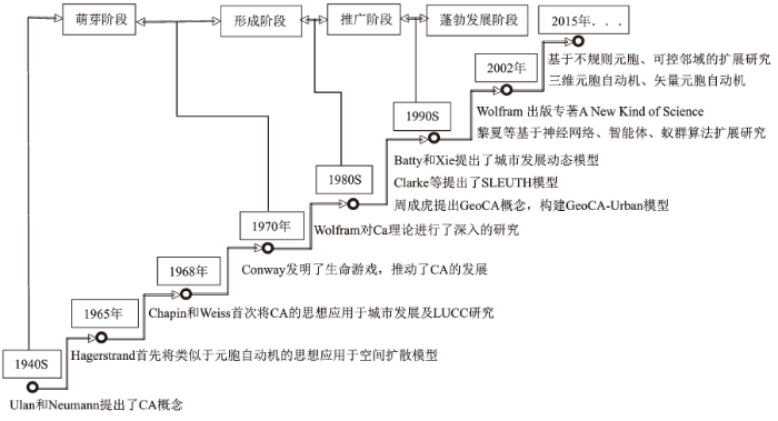
元胞自动机(Cellular Automata,CA)于20世纪40年代末由S.Ulan和J.von Neumann提出,它是一种时间、空间、状态都离散,空间相互作用和时间因果关系都为局部的网格动力学模型,具有模拟复杂系统时空演化过程的能力[1]。从20世纪70年代,英国数学家Conway的“生命游戏”概念在《Scientific American》杂志中的提出[2],到数学家、物理学家、计算机科学家Wolfram著名书籍《A New Kind of Science》的出版[3],都证明了元胞自动机用于复杂系统模拟的巨大潜力,也因此逐渐引起各领域相关学者对元胞自动机的广泛关注。元胞自动机不同于一般的数学模型,其构成方式繁多,变化多样,行为复杂,一系列模型的构造规则使其具有了强大的计算功能、平行的计算能力、高度动态以及空间概念等特征。自元胞自动机产生以来,其“自下而上”的模型构造思想就被广泛的应用于社会、经济、军事和科学研究等各个领域。在地理学中,最早可追溯到1965年,Hagerstrand首先将类似于元胞自动机的思想应用于空间扩散模型[4],1968年美国北卡莱罗那州大学的Chapin和Weiss采用离散动力学模型成功模拟了土地利用类型间的转化过程[5],1970年美国密西根大学的Waldo Tobler首先采用了元胞自动机的概念对当时美国五大湖边底特律地区的城市发展变化进行了模拟。20世纪80年代中后期,美国加利福尼亚大学——圣巴巴拉地理系的Helen Couclelis先后发表在《Environment and Planning》(A&B)上的文章对元胞自动机理论在城市动态模拟研究中的应用潜力作了充分阐述,因此奠定了元胞自动机在地理学应用的理论框架[6]。从20世纪90年代开始,元胞自动机被广泛的应用于土地利用及地貌演化、城市增长及扩散等地理学的诸多领域,在国外,加拿大学者White与荷兰学者Engelen利用元胞自动机模型对美国俄亥俄州的辛辛那提、得克萨斯州的休斯敦、威斯康星州密歇根湖西岸的密尔沃基等城市土地利用变化进行了模拟,并提出了高分辨率St.Lucia元胞自动机模型[7],英国地理学家Batty和Xie提出了城市发展动态模型(Dynamic Urban Evolution Model,简称DUEM),对美国纽约州西部伊利湖东岸的港口城市布法罗的城市扩张过程进行了系统、有效的模拟[8],此外,Clarke等提出的SLEUTH模型、Wu结合多层次分析法(AHP)与元胞自动机构建的SimLand模型[9]、Waddell结合多主体模型(MAM)提出的城市仿真模型(UrbanSim)[10]、Torren提出的SprawlSim模型[11]等都是具有代表性的城市CA模型,在理论与实际应用方面都取得了突破性进展。20世纪90年代末期,受国外研究的推动,国内越来越多的学者投身于元胞自动机的相关研究,1999年,周成虎提出了地理元胞自动机(GeoCA)的概念,在DUEM模型的基础上,构建了GeoCA-Urban模型[1],张显峰等在总结前人研究的基础上提出了土地利用演化模拟与预测((Landuse Evolution Simulation and prediction Model,简称LESP)模型[12],黎夏等人结合神经网络设计了ANN-CA模型[13],肖洪等将多智能体、元胞自动机、人口密度3种模型结合,成功模拟了长沙市人口的动态分布。另外,罗平、何春阳[14]等也分别基于不同的视角对城市CA模型进行了扩展,丰富的研究成果,不仅为政府决策、城市规划等提供科学的参考依据,同时,对城市的生态健康、长期的可持续发展建设也有着理论性、实践性的指导意义。
基于元胞自动机独特的空间结构,“自下而上”的研究思想,强大的空间集成以及并行计算能力,使其在复杂系统的模拟与预测研究中具备了较大的优势和潜力,本文回顾了CA的发展进程,较详细的介绍了CA在交通、自然灾害及土地利用等主要应用领域的研究现状,针对目前存在的问题和不足,对CA在元胞邻域、多维扩展等方面的研究趋势进行初步探讨和展望。
元胞自动机是一种具有时空计算特征的模型框架,从局部到整体的建模思想被广泛的应用于空间上离散、时间上也离散的复杂性系统模拟。标准的元胞自动机是由一系列离散且具有有限状态的元胞散落在规则格网中,并遵循同样的作用准则,按照确定的局部规则作同步更新,通过大量元胞在局部空间中的相互作用构成复杂的动态演化系统。
随着经济的全球化发展,人员和货物流动空前活跃,随之带来的交通事故、交通拥堵等问题也越来越严重。为了有效减少或避免交通问题的产生,交通仿真模拟问题逐渐成为国内外相关学者关注的热点问题。交通是一个复杂系统,涉及到的车辆、行人等因素从本质上讲是离散的,因此,作为一个离散系统动力学模型的元胞自动机对交通模拟具有非常明显的优势。20世纪80年代,Cremer和Ludwig首先提出了基于元胞自动机的交通模型[15],1986年,Stephen Wolfram提出了最基本的一维元胞自动机交通模型,即Wolfram 184号CA,用于模拟高速公路或城市交通环线上的一维交通流[16];1992年德国学者Nagel等[17]对184号CA模型加以改进,提出了NaSch(简写为N-S)模型,该模型主要在184号CA模型的基础上将车辆的行进速度加以考虑;1996年日本学者将NaSch模型简化,提出了F-I模型[18];此外,美国学者Middleton等人基于纵横交错的二维交通网络提出了二维元胞自动机交通模型,即BML模型,利用该模型成功模拟了城市交通阻塞等现象[19]。在国内,汪秉宏提出了一种介于N-S模型和F-I模型之间的WWH模型[20],薛郁等也对N-S模型进行了改进[21]。
众所周知,森林是生物赖以生存的家园,是水土保持、防治污染、维持生态平衡等不可或缺的重要自然资源。然而,随着经济的发展,人类对林木的需求和影响逐渐加强,森林也遭受到了各个方面灾害。20世纪80年代开始,全球气候变暖,森林火灾次数有明显的上升趋势,严重威胁到了森林生态和人类的生命财产安全,因此,准确认识林火发展规律,模拟火势扩散趋势,对火灾的扑救和有效防治具有重要意义。1992年国外学者Drossel等人[22]将Monte Carlo模拟方法与元胞自动机模型结合,二维格网的结点代表一棵独立的树木,状态值记为“1”,树木着火则状态值记为“0”,根据某棵树木冯-诺依曼型邻域内所有树木的状态值计算该棵树木下一时刻的状态转换概率,进而模拟复杂火灾的蔓延趋势,该模型被称为最经典的CA林火模拟模型。
山体滑坡、泥石流、火山熔岩流以及地震等自然灾害对人类的生命财产安全有着非常严重的威胁,因而已经逐渐引起世界各国政府和科技工作者的高度关注,这些自然灾害的发生和演变过程极为复杂,不仅具有时空的动态性,空间的分异性,同时受到自然、社会、经济等各方面不确定性因素的影响,所以,一般的统计经验模型和微分方程等数学模型很难准确并有效的预测和防治自然灾害,从而降低灾害损失。20世纪80年代,CRISCI等[23]将元胞自动机应用于自然灾害模拟,90年代初,Nakanishi提出将元胞自动机应用于地震的动态演化过程[24],Smith等基于CA理论简单设计了模拟地形侵蚀过程的模型[25],Barca利用CA模型模拟了火山熔岩流的流动演变过程[26],这些都足以说明CA模型在模拟自然灾害研究中的可行性, Gregorio等[27]也利用CA模型对泥石流、滑坡等复杂自然灾害系统的演变过程进行了深入研究,并对前人的研究方法进行了完善和总结,国内学者张文婷[28]等也基于CA模型在水土流失领域进行了相关研究。此外,CA模型也被广泛的应用于岩石断裂演化的模拟中,越来越多的研究成果都证明了元胞自动机更广阔的研究领域和重要实践意义。
土地资源是人类生产生活中最基本、最重要的资源,它不仅是社会经济生活中工农业生产和各类贸易往来、衣食住行等活动的主要场所和载体,同时,土地利用与土地覆被变化也时刻影响着全球的生态环境与气候变化[29],因此,研究土地利用格局演变,揭示土地利用变化的驱动机制,不仅可以指导区域土地利用调控和土地规划决策,促进全球的生态环境朝着有利于人类健康的方向发展,而且,对于当前土地利用空间格局中存在的现实问题的解决具有重要的指导意义。ArsanjaniJokar等人将马尔科夫链、逻辑回归等思想应用于元胞自动机模型,较准确的实现了城市用地的扩展模拟[30],Jamal等人在元胞自动机模型中引入智能体思想,采用影响城市增长的房地产开发商、政府和居民等作为智能体,成功的模拟了伊朗首都德黑兰的城市扩张过程[31],Kheder以多时相遥感影像为数据基础,将模糊理论与元胞自动机相结合,较高精度的完成了美国印第安纳州最大城市——印第安纳波利斯的扩展模拟[32],Cláudia等人对元胞的状态转变方向作了重点研究,实现了向多个目标地类转变的转化概率计算方法,大大提高了元胞自动机在土地利用演变过程的模拟精度[33],国内学者将案例推理[34]、智能体[35]、神经网络[13]以及主成分分析[36]等应用于元胞自动机模型,杨俊等基于CA模型对河北省旅游小镇——三坡镇的时空增长过程进行了模拟[37],郭欢欢等将多主体与元胞自动机结合,初步探讨并分析了该模型的应用优势及存在问题[38],吴浩等人基于CA模型提出了土地利用变化模拟的尺度分析方法[39],但以上研究多集中在元胞的单目标模拟。
另外,直观的元胞自动机空间模型也被广泛的应用于景观格局模拟和空间生态学的研究中,将马尔科夫链等生态学模型结合到元胞自动机模型的邻域规则中,不仅可以反映景观格局演变的结果,也可以反映出其演变的过程。1994年,墨尔本大学学者Robert M. Itami利用CA模型模拟了城市景观演化过程[40],Syphard等人基于CA模型,模拟并预测了加利福尼亚南部地区的景观格局变化情况[41],Balzter等人基于物种竞争、共存、继承等行为理论,将马尔科夫链与CA结合,成功模拟了植被景观的动态演变过程[42],Sprott[43]等人也基于CA模型模拟了森林景观的动态变化,足以说明CA模型在土地利用/覆被变化研究中广阔的应用前景。
作为CA研究的核心,元胞转换规则的定义一直是国内外学者们关注的焦点,而针对于复杂的自然系统,需要根据不同的应用分别转换规则来控制元胞状态的转变。随着CA研究的不断深入,其应用领域也在不断的拓宽,元胞转换规则的获取方法也越来越多,从Wolfam经典的110规则、184规则到近年来国内通过多准则、Logistic回归、数据挖掘等方法获取的转换规则,一次又一次的将CA研究推向新的高潮,新的领域,伴随而来的则是其趋向于瓶颈的研究趋势。转换规则固然重要,然而,面对现实世界中邻域范围并不规则的地理实体以及越来越立体化的城市空间扩展趋势,基于二维的规则元胞自动机也逐渐曝露出明显的缺陷和不足,国内外学者逐渐将研究重点转移到元胞邻域扩展、元胞维度以及矢量元胞自动机,为元胞自动机的进一步研究提供了新的思路。
标准元胞自动机模型的元胞一般是具备相同转变规则的几何形状,如正三角形、正方形、正六边形等规律地排列在元胞空间中,其邻域空间的定义也比较严格,在一维CA模型中,通常认为距离某元胞内的所有元胞规定为该元胞的邻域范围,在二维CA模型中,以Von.Neumann型、Moore型等方法规定元胞邻域范围,而现实生活中,同时具备相同规则且严格定义邻域范围的地理实体相对较少,因此,标准元胞自动机对真实世界的模拟也存在着一定的缺陷,有必要对其元胞空间和邻域范围进行相应的扩展研究。Nuno Norte Pinto等人基于遥感影像的像素点,以不规则元胞代替常规元胞构建元胞自动机模型,成功的模拟并预测了Condeixa-a-Nova自治区的城市变迁过程[44],Daniel Stevens等人基于不规则元胞自动机模型,对加拿大萨斯喀彻温省南萨斯喀彻温河中南部城市萨斯卡通的土地利用格局演变过程进行了相关研究[45],Ivan在标准元胞自动机的基础上,对元胞的邻域范围进行了扩展,设计了一种不规则邻域元胞自动机模型[46],国内学者刘兴权等人利用二分Logistic回归方法,引入邻域因子,并建立了可控邻域元胞自动机模型,成功模拟并预测了长沙市区及其周边地区的城市扩张过程[47]。
目前,基于元胞自动机的复杂系统模拟研究不论是在结构上、逻辑上还是在表现形式上,大多数还都局限于二维空间,然而,在城市横向蔓延和纵向拓展并举的当代,城市的发展日渐体现出高效立体的空间组合形式,因此,基于二维空间的动态发展模拟并不能准确描述当今高楼林立的城市空间发展趋势,许多学者相继开展了基于三维元胞自动机模型的城市扩张模拟[48]。Semboloni将White的二维CA 模型向三维扩展,改进了二维CA不能使用离散的参数表达的缺陷[49],Bengguigui等人提出城市3DCA模型,采用不同参数模拟城市发展的不同阶段并作出合理解释,但该模型在研究的过程中忽略了区域异性的特点,缺少三维可视化展示[50],张乐珊采用VR-GIS技术对Bengguigui模型进行了三维显示,并结合多主体模型对沿海小镇进行了城市三维空间增长模拟,秦静等人借鉴经典的城市空间增长模拟方法,以城市发展的自组织性为理论依据,扩充了Bengguigui等的城市空间增长三维元胞自动机(3DCA)模型,在原模型的基础上分别加入中心距离及交通距离评价因子构建出新的模型,并使用NetLogo 3D建模工具进行城市三维空间增长仿真模拟实验,通过对比实验结果进一步探讨了三维城市空间增长的规律[51]。
栅格数据将二维空间划分为具有相同规则的网格,其特有的数据结构不仅易于匹配遥感数据,方便数学模拟,而且与元胞自动机模型的构成单元相互耦合,相比于通过离散的坐标点来描述地理要素的矢量数据,在模型的建立、数据的计算等方面,栅格数据更优势,因此,以往的研究中,多数以栅格数据建立元胞自动机模型,以栅格数据的像元作为元胞,像元值即为元胞状态,但是,现实世界中的大部分地理实体都是不规则的多边形形状,基于栅格数据建立的元胞自动机模型,元胞形状统一,大小一致,元胞大小及邻域的确定都将对模拟结果造成影响,在反映地理实体的精度上存在着一定缺陷。21世纪初,国外学者Andreas Flache等人利用平面上的随机点构建泰森多边形,每个泰森多边形代表一个元胞空间,但是并不能准确的确定每个多边形内的土地类型,即元胞状态存在着不确定性[52],2001年O'Sullivan利用实际地物代表每个元胞,基于图论和地图代数建立了矢量元胞自动机模型[53],随后,Niandry Moreno等人在矢量元胞自动机的邻域定义上进行了相关研究,指出矢量元胞的邻域范围可以有缓冲区分析和动态转移矩阵两种确定方式[54],国内学者陈健等人对矢量元胞自动机模型的转换规则作了扩展研究[55]。元胞自动机的提出、发展以及未来研究趋势如图1所示。
元胞自动机不仅仅是模拟复杂系统行为的动力学模型,同时也作为认识和理解客观世界的一种新科学被人们所接受,“自下而上”的研究思想,高性能的并行计算能力,使其被广泛的应用于交通、林火以及土地利用等各个邻域,随着研究的不断深入,元胞自动机作为模拟地理实体的微观个体模型所面临的问题和质疑也越来越多,首先,体现在标准的元胞结构将复杂地理实体形状规则化,元胞大小的确定缺少更有力的科学依据,导致模拟结果存在许多不确定性,另外,经济不断提高,科技不断发展,人口结构逐渐复杂化,土地利用和城市变迁呈现立体化,简单的二维CA模型并不能完全准确的反映这些复杂的演变过程,不规则元胞、可变邻域以及矢量元胞自动机更能真实的反映地理实体,而三维元胞自动机的发展将更形象、更准确的展示并预测城市扩张过程。因此,分析元胞及其邻域的扩展、三维元胞自动机、矢量元胞自动机将很有可能成为未来的研究热点。
The authors have declared that no competing interests exist.
| [1] |
|
| [2] |
The fantastic combinations of John Conway's new solitaire game "life" [J]. |
| [3] |
A New Kind of Science [M]: |
| [4] |
A Monte Carlo approach to diffusion [J].https://doi.org/10.1017/S0003975600001132 URL [本文引用: 1] 摘要
Torsten H盲gerstrandThe nebula-like cluster is a common trait in the spatial picture of man's attributes. Take any atlas showing economic or cultural elements and you will find an endless sequence of spatial distributions which have a concentrated core surrounded by a border zone of outwards decreasing density.
|
| [5] |
A probabilistic model for residential growth [J].https://doi.org/10.1016/0041-1647(68)90103-2 URL [本文引用: 1] |
| [6] |
Cellular worlds: a framework for modeling micro - macro dynamics [J].https://doi.org/10.1068/a170585 URL [本文引用: 1] 摘要
Cellular spaces have recently received a lot of attention in computer science and elsewhere as models capable of bridging the gap between disaggregate and aggregate description. Despite their obvious spatial interpretation, standard cell-space models are too constrained by their background conventions to be useful in realistic geographic applications. In this paper, a generalization of the cell-space principle is presented, based on discrete model theory, and then applied to a hypothetical but fairly complex problem of individual decision and large-scale urban change. The paper ends with a discussion of the wider import of this methodology, which has close links with, among other things, bifurcation theory, cognitive science modeling of individual decision and behavior, and other issues of actual or potential interest to geographers.
|
| [7] |
Cellular automata as the basis of integrated dynamic regional modelling [J].https://doi.org/10.1068/b240235 URL [本文引用: 1] 摘要
We present an integrated model of regional spatial dynamics consisting of a cellular automaton-based model of land use linked both to a geographic information system (GIS) and to standard nonspatial models of regional economics and demographics, as well as to a simple model of environmental change. The operation of the model is illustrated with an application to the island of St Lucia developed for the purpose of providing insights into the possible socioeconomic consequences for the island of global climate change. On the basis of results from this and other applications of the model, we conclude that cellular automata not only permit a detailed modelling and realistic prediction of land-use patterns, but they also provide a means of introducing the effects of spatially localized environmental factors, as represented in the GIS, into the operation of standard economic and demographic models, which are otherwise unconstrained.
|
| [8] |
Modeling urban dynamics through GIS-based cellular automata. Computers [J],https://doi.org/10.1016/S0198-9715(99)00015-0 URL [本文引用: 1] 摘要
In urban systems modeling, there are many elaborate dynamic models based on intricate decision processes whose simulation must be based on customized software if their space–time properties are to be explored effectively. In this paper we present a class of urban models whose dynamics are based on theories of development associated with cellular automata (CA), whose data is fine-grained, and whose simulation requires software which can handle an enormous array of spatial and temporal model outputs. We first introduce the generic problem of modeling within GIS, noting relevant CA models before outlining a generalized model based on Xie's (1996, A general model for cellular urban dynamics. Geographical Analysis, 28 , 350–373) “dynamic urban evolutionary modeling” (DUEM) approach. We present ways in which land uses are structured through their life cycles, and ways in which existing urban activities spawn locations for new activities. We define various decision rules that embed distance and direction, density thresholds, and transition or mutation probabilities into the model's dynamics, and we then outline the software designed to generate effective urban simulations consistent with GIS data inputs, outputs and related functionality. Finally, we present a range of hypothetical urban simulations that illustrate the diversity of model types that can be handled within the framework as a prelude to more realistic applications which will be reported in later papers.
|
| [9] |
Simulating urban encroachment on rural land with fuzzy-logic-controlled cellular automata in a geographical information system [J]https://doi.org/10.1006/jema.1998.0195 URL [本文引用: 1] 摘要
Encroachment on rural land is a serious problem in developing countries, particularly in regions that are undergoing rapid economic development. Monitoring and simulating land conversions thus are critical to the formulation of a sustainable development strategy. This paper describes a computer-based approach for simulating land encroachment with fuzzy-logic-controlled cellular automata (CA). Unlike CA models developed in the domain of natural sciences, this simulation model seeks to integrate rule definition with explicit, interactive and heuristic decision-making processes. Fuzzy logic was used to capture the feature of land conversion behaviour, while CA was to used to simulate global pattern from local rules and implemented in a geographical information system (GIS) using ARC/INFO software. By providing a series of simulation scenarios, the study reveals potential hazardous consequences inherent in some development policies that would jeopardize sustainable development of the region and demonstrates that this approach is a useful tool to provide decision support. 1998 Academic Press
|
| [10] |
UrbanSim: Modeling Urban Development for Land Use, Transportation, and Environmental Planning [J].https://doi.org/10.1080/01944360208976274 URL [本文引用: 1] 摘要
Large urban areas have come under intense pressure to respond to federal mandates to link planning of land use, transportation, and environmental quality; and from citizen concerns about managing the side effects of growth including sprawl, congestion, housing affordability, and loss of open space. Planning models used by metropolitan planning organizations were generally not designed to address these issues, creating a gap in the ability of planners to systematically assess them. UrbanSim is a new model system developed to respond to these emerging requirements and has now been applied in 3 metropolitan areas. This paper describes the model system and its application to the area of Eugene-Springfield, Oregon.
|
| [11] |
|
| [12] |
集成GIS和细胞自动机模型进行地理时空过程模拟与预测的新方法. 测绘学报 [J],https://doi.org/10.3321/j.issn:1001-1595.2001.02.009 URL [本文引用: 1] 摘要
目前商用地理信息系统(GIS)不能完整地表达地理实体的时态信息和时空关系,缺乏时空分析和时空动态模拟的能力,这已成为GIS界的一个共识.然而,未来GIS在各应用领域的深入发展以及在实现“数字地球”战略过程中,都要求发展新的时空分析和模拟方法.细胞自动机(Cellular Automaton)是一种“自下而上”的动态模拟建模框架,具有模拟地理复杂系统时空演化过程的能力.首先将标准CA模型的4元组进行扩展以满足GIS环境下时空动态模拟的要求,然后以城市土地利用演化这一动态过程为例,建立了土地利用演化动态模拟与预测模型(LESP),最后运用此模型对包头市城市扩展和土地可持续利用演化进行了比较成功的模拟和预测.
Integrating GIS with Cellular Automaton Model to Establish a New Approach for Spatio-temporal Process Simulation and Prediction. https://doi.org/10.3321/j.issn:1001-1595.2001.02.009 URL [本文引用: 1] 摘要
目前商用地理信息系统(GIS)不能完整地表达地理实体的时态信息和时空关系,缺乏时空分析和时空动态模拟的能力,这已成为GIS界的一个共识.然而,未来GIS在各应用领域的深入发展以及在实现“数字地球”战略过程中,都要求发展新的时空分析和模拟方法.细胞自动机(Cellular Automaton)是一种“自下而上”的动态模拟建模框架,具有模拟地理复杂系统时空演化过程的能力.首先将标准CA模型的4元组进行扩展以满足GIS环境下时空动态模拟的要求,然后以城市土地利用演化这一动态过程为例,建立了土地利用演化动态模拟与预测模型(LESP),最后运用此模型对包头市城市扩展和土地可持续利用演化进行了比较成功的模拟和预测.
|
| [13] |
基于神经网络的元胞自动机及模拟复杂土地利用系统 [J].
<p>本文提出了基于神经网络的元胞自动机(CellularAutomata),并将其用来模拟复杂的土地利用系统及其演变。国际上已经有许多利用元胞自动机进行城市模拟的研究,但这些模型往往局限于模拟从非城市用地到城市用地的转变。模拟多种土地利用的动态系统比一般模拟城市演化要复杂得多,需要使用许多空间变量和参数,而确定模型的参数值和模型结构有很大困难。本文通过神经网络、元胞自动机和GIS相结合来进行土地利用的动态模拟,并利用多时相的遥感分类图像来训练神经网络,能十分方便地确定模型参数和模型结构,消除常规模拟方法所带来的弊端。</p>
Cellular automata for simulating complex landuse systems using neural networks.
<p>本文提出了基于神经网络的元胞自动机(CellularAutomata),并将其用来模拟复杂的土地利用系统及其演变。国际上已经有许多利用元胞自动机进行城市模拟的研究,但这些模型往往局限于模拟从非城市用地到城市用地的转变。模拟多种土地利用的动态系统比一般模拟城市演化要复杂得多,需要使用许多空间变量和参数,而确定模型的参数值和模型结构有很大困难。本文通过神经网络、元胞自动机和GIS相结合来进行土地利用的动态模拟,并利用多时相的遥感分类图像来训练神经网络,能十分方便地确定模型参数和模型结构,消除常规模拟方法所带来的弊端。</p>
|
| [14] |
大都市区城市扩展模型——以北京城市扩展模拟为例 [J].https://doi.org/10.3321/j.issn:0375-5444.2003.02.017 URL [本文引用: 1] 摘要
在分析大都市区城市扩展特征的基础上,从宏观外部约束性因素和局 部城市单元自身扩展能力变化共同作用影响城市发展演变的角度,构建了一个模拟和预测大都市区城市发展演变过程的城市扩展模型(City Expanding Model in Metropolitan Area;CEM).首先对北京1975~1997年的城市发展过程进行模拟重建,然后在此基础上从城镇用地数量最优和位置最佳相结合的角度对北京 2005~2015年的城市发展格局进行了预测.结果表明,在对各种影响因素进行严格标准化并利用自适应Monte-Carlo方法多次模拟确定最佳影响 权重的基础上,该模型可以在一定程度上反映城市发展,尤其是大都市区城市发展演变的特征和规律.
City Expansion Model of Metropolitan Area in China:a Case Study of Beijing. https://doi.org/10.3321/j.issn:0375-5444.2003.02.017 URL [本文引用: 1] 摘要
在分析大都市区城市扩展特征的基础上,从宏观外部约束性因素和局 部城市单元自身扩展能力变化共同作用影响城市发展演变的角度,构建了一个模拟和预测大都市区城市发展演变过程的城市扩展模型(City Expanding Model in Metropolitan Area;CEM).首先对北京1975~1997年的城市发展过程进行模拟重建,然后在此基础上从城镇用地数量最优和位置最佳相结合的角度对北京 2005~2015年的城市发展格局进行了预测.结果表明,在对各种影响因素进行严格标准化并利用自适应Monte-Carlo方法多次模拟确定最佳影响 权重的基础上,该模型可以在一定程度上反映城市发展,尤其是大都市区城市发展演变的特征和规律.
|
| [15] |
A fast simulation model for traffic flow on the basis of boolean operations [J]. |
| [16] |
Theory and applications of cellular automata: includes selected papers 1983 - 1986 [M]: |
| [17] |
A Cellular Automaton Model for Freeway Traffic [J].https://doi.org/10.1051/jp1:1992277 URL [本文引用: 1] 摘要
We introduce a stochastic discrete automaton model to freeway traffic. Monte-Carlo simulations of the model show a transition from laminar traffic flow to start-stop-waves with increasing vehicle density, as is observed in real freeway traffic. For special cases analytical results can be obtained.
|
| [18] |
Traffic Flow in 1D Cellular Automaton Model Including Cars Moving with High Speed [J].https://doi.org/10.1143/JPSJ.65.1868 URL [本文引用: 1] 摘要
Traffic flow is simulated by one-dimensional cellular automaton (CA) model including cars moving with high speed. The simulation shows a phase transition between the moving phase and the jamming phase at p = 1/(m + 1) (p : density of cars, m : the maximum number of sites by which cars advance at each time step). A mean-field theory can reproduce the average velocity found by simulations.
|
| [19] |
Self-organization and a dynamical transition in traffic-flow models [J]. |
| [20] |
Cellular automaton traffic flow model between the Fukui-Ishibashi and Nagel-Schreckenberg models [J].https://doi.org/10.1103/PhysRevE.63.056117 URL PMID: 11414971 [本文引用: 1] 摘要
We propose and study a new one-dimensional traffic flow cellular automaton (CA) model of high speed vehicles with the Fukui-Ishibashi-type acceleration for all cars and the Nagel-Schreckenberg-type (NS) stochastic delay only for the cars following the trail of the car ahead. The main difference in the delay scenario between the new model and the NS model is that a car with spacing ahead longer than the velocity limit $M$ may not be delayed in the new model. By using a car-oriented mean field theory, we derive the fundamental diagrams of the average speed as the function of car density analytically. Our theoretical results are in excellent agreement with numerical simulations.
|
| [21] |
一种改进的一维元胞自动机交通流模型及减速概率的影响 [J].
在Nagel-Schrekenberg单车道元胞自动机交通流模型的基础上,考虑车辆之间的相对运动以及车辆减速概率对交通状态的影响,提出了一种改进的单车道元胞自动机交通流模型.并以该模型进行计算机模拟,结果表明,在车流状态的演化过程中,通过确定减速概率与车辆密度的指数v关系来控制车流量,不同的v值车流量不同,对车辆运动出现堵塞相的相变点有影响.当v约为0.75时,模拟结果与实测结果符合.随着车辆密度的增加,车辆的局域聚集程度加大,平均速度下降增大,将出现不稳定的车辆聚集的堵塞相.在车辆的运动过程中,车流的运
An improved one-dimensional cellular automaton modelof traffic flow and the effect of deceleration probability.
在Nagel-Schrekenberg单车道元胞自动机交通流模型的基础上,考虑车辆之间的相对运动以及车辆减速概率对交通状态的影响,提出了一种改进的单车道元胞自动机交通流模型.并以该模型进行计算机模拟,结果表明,在车流状态的演化过程中,通过确定减速概率与车辆密度的指数v关系来控制车流量,不同的v值车流量不同,对车辆运动出现堵塞相的相变点有影响.当v约为0.75时,模拟结果与实测结果符合.随着车辆密度的增加,车辆的局域聚集程度加大,平均速度下降增大,将出现不稳定的车辆聚集的堵塞相.在车辆的运动过程中,车流的运
|
| [22] |
Computer simulation of firest-fire model [J]. |
| [23] |
Lava flow simulation by a discrete cellular model: first implementation [J].
; ; ; ; Univ. studi Calabria, dip. sci. terra, Arcavacata di Rende 87036, ITALIEIMSIEK 1986, vol. 6, n4, pp. 137-140 (10 ref.)AnglaisActa Press, Anaheim, CA, ETATS-UNIS (1981) (Revue)INIST-CNRS, Cote INIST : 19697
|
| [24] |
Cellular-automaton model of earthquakes with deterministic dynamics [J].https://doi.org/10.1103/PhysRevA.41.7086 URL PMID: 9903137 [本文引用: 1] 摘要
A cellular-automaton model of threshold elements with deterministic dynamics is introduced. The model is a cellular-automaton version of the mechanical earthquake model invented originally by Burridge and Knopoff [Bull. Seismol. Soc. Am. 57, 341 (1967)] and studied recently by Carlson and Langer [Phys. Rev. Lett. 62, 2632 (1989); Phys. Rev. A 40, 6470 (1989)]. Randomness exists only in initial configurations. Numerical results show that the distribution function of the event magnitudes has a scaling region consistent with the Gutenberg-Richter law.
|
| [25] |
The application of cellular automata to the erosion of landforms [J].https://doi.org/10.1002/esp.3290160307 URL [本文引用: 1] 摘要
Not Available
|
| [26] |
Cellular automata for simulating lava flows: A method and examples of the Etnean eruptions [J]. |
| [27] |
High performance scientific computing by a parallel cellular environment [J]. |
| [28] |
基于元胞自动机的流域水土流失时空动态变化研究 [J].
本文提出一种结合元胞自动机的 区域水土流失预测模型,采用线性神经网络方法预测区域土地利用总体变化趋势;同时考虑道路、商服中心对城市土地利用覆盖的影响,制定元胞自动机转换规则, 预测区域未来土地利用覆盖情况,预测精度达到72%。最后,将CA预测数据作为变量输入通用土壤流失方程,预测区域水土流失情况。并以武汉市东湖流域为例 对其水土流失问题进行了现状分析及预测,为其水土流失整治提供参考。
Spatial-temporal evolution of soil water erosion in Donghu watershed based on cellular automata.
本文提出一种结合元胞自动机的 区域水土流失预测模型,采用线性神经网络方法预测区域土地利用总体变化趋势;同时考虑道路、商服中心对城市土地利用覆盖的影响,制定元胞自动机转换规则, 预测区域未来土地利用覆盖情况,预测精度达到72%。最后,将CA预测数据作为变量输入通用土壤流失方程,预测区域水土流失情况。并以武汉市东湖流域为例 对其水土流失问题进行了现状分析及预测,为其水土流失整治提供参考。
|
| [29] |
|
| [30] |
Integration of logistic regression, Markov chain and cellular automata models to simulate urban expansion [J].https://doi.org/10.1016/j.jag.2011.12.014 URL [本文引用: 1] 摘要
This research analyses the suburban expansion in the metropolitan area of Tehran, Iran. A hybrid model consisting of logistic regression model, Markov chain (MC), and cellular automata (CA) was designed to improve the performance of the standard logistic regression model. Environmental and socio-economic variables dealing with urban sprawl were operationalised to create a probability surface of spatiotemporal states of built-up land use for the years 2006, 2016, and 2026. For validation, the model was evaluated by means of relative operating characteristic values for different sets of variables. The approach was calibrated for 2006 by cross comparing of actual and simulated land use maps. The achieved outcomes represent a match of 89% between simulated and actual maps of 2006, which was satisfactory to approve the calibration process. Thereafter, the calibrated hybrid approach was implemented for forthcoming years. Finally, future land use maps for 2016 and 2026 were predicted by means of this hybrid approach. The simulated maps illustrate a new wave of suburban development in the vicinity of Tehran at the western border of the metropolis during the next decades.
|
| [31] |
de Noronha Vaz E. Spatiotemporal simulation of urban growth patterns using agent-based modeling: The case of Tehran [J].https://doi.org/10.1016/j.cities.2013.01.005 URL [本文引用: 1] 摘要
Rapid urban growth is becoming a serious problem in most developing countries. Tehran, the capital of Iran, stands out as a vibrant metropolitan area, facing uncontrolled urban expansion. Public authorities and decision makers require planning criteria regarding possible spatial developments. To monitor past developmental trends and to simulate emerging spatiotemporal patterns of urban growth, this research applies a geosimulation approach that couples agent-based modeling with multicriteria analysis (MCA) for the period between 1986 and 2006. To model the major determinants controlling urban development, three agent groups are defined, namely developer agents, government agents, and resident agents. The behaviors of each agent group are identified by qualitative surveys and are considered separately using multi-criteria analysis. The interactions of the agents are then combined through overlay functions within a Geographic Information System (GIS). This analysis results in the creation of a propensity surface of growth that is able to identify the most probable sites for urban development. Subsequently, a Markov Chain Model (MCM) and a concise statistical extrapolation are used to determine the amount of probable future expansion in Tehran. For validation purposes, the model is estimated using 2011 data and then validated based on actual urban expansion. Given the accurate predictions of the Markov Chain Model, further predictions were carried out for 2016 and 2026. This simulation provides strong evidence that during the next decade planning authorities will have to cope with continuous as well as heterogeneously distributed urban growth. Both the monitoring of growth and simulation revealed significant developments in the northwestern part of Tehran, continuing toward the south along the interchange networks.
|
| [32] |
Fuzzy inference guided cellular automata urban-growth modelling using multi-temporal satellite images [J]. |
| [33] |
Stochastic cellular automata modeling of urban land use dynamics: empirical development and estimation. Computers [J],https://doi.org/10.1016/S0198-9715(02)00042-X URL [本文引用: 1] 摘要
An increasing number of models for predicting land use change in rapidly urbanizing regions are being proposed and built using ideas from cellular automata (CA). Calibrating such models to real situations is highly problematic and to date, serious attention has not been focused on the estimation problem. In this paper, we propose a structure for simulating urban change based on estimating land use transitions using elementary probabilistic methods which draw their inspiration from Bayes' theory and the related 'weights of evidence' approach. These land use change probabilities drive a CA model based on eight cell Moore neighborhoods implemented through empirical land use allocation algorithms. The model framework has been applied to a medium-sized town, Bauru, in the west of S茫o Paulo State, Brazil. We show how various socio-economic and infrastructural factors can be combined using the weights of evidence approach which enables us to predict the probability of changes between land use types in different cells of the system. Different predictions for the town during the period 1979-1988 were generated, and statistical validation was then conducted using a multiple resolution fitting procedure. These modeling experiments support the essential logic of adopting Bayesian empirical methods which synthesize various information about spatial infrastructure as the driver of urban land use change. This indicates the relevance of the approach for generating forecasts of growth for Brazilian cities in particular and for worldwide cities in general.
|
| [34] |
基于案例推理的元胞自动机及大区域城市演变模拟 [J].
<p>元胞自动机(CA) 被越来越多地用于复杂系统的模拟中。许多地理现象的演变与其影响要素之间存在着复杂的关系, 并往往具有时空动态性。在研究区域较大和模拟时间较长时, 定义具体的规则来反映这种复杂关系有较大的困难。为了解决CA 转换规则获取的瓶颈问题, 提出了基于案例推理(CBR) 的CA 模型, 并对CBR 的k 近邻算法进行了改进, 使其能反映转换规则的时空动态性。将该模型应用于大区域的珠江三角洲城市演变中。实验结果显示, 其模拟的空间格局与实际情况吻合较好。与常规的基于Logistic 的CA 模型进行了对比, 所获得的模拟结果有更高的精度和更接近实际的空间格局, 特别在模拟较为复杂的区域时有更好的模拟效果。</p>
Case-based Cellular Automaton for Simulating Urban Development in a Large Complex Region.
<p>元胞自动机(CA) 被越来越多地用于复杂系统的模拟中。许多地理现象的演变与其影响要素之间存在着复杂的关系, 并往往具有时空动态性。在研究区域较大和模拟时间较长时, 定义具体的规则来反映这种复杂关系有较大的困难。为了解决CA 转换规则获取的瓶颈问题, 提出了基于案例推理(CBR) 的CA 模型, 并对CBR 的k 近邻算法进行了改进, 使其能反映转换规则的时空动态性。将该模型应用于大区域的珠江三角洲城市演变中。实验结果显示, 其模拟的空间格局与实际情况吻合较好。与常规的基于Logistic 的CA 模型进行了对比, 所获得的模拟结果有更高的精度和更接近实际的空间格局, 特别在模拟较为复杂的区域时有更好的模拟效果。</p>
|
| [35] |
多智能体与元胞自动机结合及城市用地扩张模拟 [J].
运用多智能体(Agent)和元胞自动机(CA)结合来模拟城市用地扩张的方法,将影响和决定用地类型转变的主体作为Agent引进元胞自动机模型中,Agent在CA确定的城市发展概率的基础上,通过自身及其周围环境的状况,综合各种因素的影响做出决策,决定元胞下一时刻的城市发展概率。运用Agent的决策结果,对CA模型中以随机变量体现的不确定性通过Agent决策行为给予地理意义的新解释。以城市郊区—樟木头镇为例,对1988~1993年城市用地扩张进行了模拟研究,取得了良好的模拟效果。
Integration of Multi-agent System swith Cellular Automata for Simulating Urban Land Expansion.
运用多智能体(Agent)和元胞自动机(CA)结合来模拟城市用地扩张的方法,将影响和决定用地类型转变的主体作为Agent引进元胞自动机模型中,Agent在CA确定的城市发展概率的基础上,通过自身及其周围环境的状况,综合各种因素的影响做出决策,决定元胞下一时刻的城市发展概率。运用Agent的决策结果,对CA模型中以随机变量体现的不确定性通过Agent决策行为给予地理意义的新解释。以城市郊区—樟木头镇为例,对1988~1993年城市用地扩张进行了模拟研究,取得了良好的模拟效果。
|
| [36] |
基于元胞自动机的城市发展密度模拟 [J].https://doi.org/10.3969/j.issn.1000-0690.2006.02.007 URL [本文引用: 1] 摘要
元胞自动机CA越来越多地被用于模拟复杂的城市系统,但这些模拟基本不考虑城市的发展密度。不同的城市发展密度会对城市的形态有很大的影响,有必要将城市的发展密度引进CA的城市模拟中,以获得更好的模拟结果。本文将密度梯度函数引进了CA模型的转换规则中,并定义‘灰度’来反映状态的转换。利用该模型对不同可能的城市发展组合进行了模拟,为城市规划提供了辅助依据。
Ye Jia'an. Simulating urban development density using cellular automata. https://doi.org/10.3969/j.issn.1000-0690.2006.02.007 URL [本文引用: 1] 摘要
元胞自动机CA越来越多地被用于模拟复杂的城市系统,但这些模拟基本不考虑城市的发展密度。不同的城市发展密度会对城市的形态有很大的影响,有必要将城市的发展密度引进CA的城市模拟中,以获得更好的模拟结果。本文将密度梯度函数引进了CA模型的转换规则中,并定义‘灰度’来反映状态的转换。利用该模型对不同可能的城市发展组合进行了模拟,为城市规划提供了辅助依据。
|
| [37] |
Spatiotemporal simulation of tourist town growth based on the cellular automata model: the case of Sanpo Town in Hebei Province [J].https://doi.org/10.1155/2013/975359 URL [本文引用: 1] 摘要
Spatiotemporal simulation of tourist town growth is important for research on land use/cover change under the influence of urbanization. Many scholars have shown great interest in the unique pattern of driving urban development with tourism development. Based on the cellular automata (CA) model, we simulated and predicted the spatiotemporal growth of Sanpo town in Hebei Province, using the tourism urbanization growth model. Results showed that (1) average annual growth rate of the entire region was 1.5 Ha(2) per year from 2005 to 2010, 4 Ha(2) per year from 2010 to 2015, and 2.5 Ha(2) per year from 2015 to 2020; (2) urban growth rate increased yearly, with regional differences, and had a high degree of correlation with the Euclidean distance of town center, traffic route, attractions, and other factors; (3) Gougezhuang, an important village center in the west of the town, demonstrated traffic advantages and increased growth rate since 2010; (4) Magezhuang village has the largest population in the region, so economic advantages have driven the development of rural urbanization. It showed that CA had high reliability in simulating the spatiotemporal evolution of tourist town, which assists the study of spatiotemporal growth under urbanization and rational protection of tourism resources.
|
| [38] |
元胞自动机和多主体模型在土地利用变化模拟中的应用 [J].https://doi.org/10.11820/dlkxjz.2011.11.002 Magsci [本文引用: 1] 摘要
土地利用变化模拟研究是土地利用变化研究的重要分支。复杂系统理论的完善和系统模拟平台的发展使得复杂系统模拟方法在土地利用变化模拟研究中的优势越来越明显,元胞自动机模型和多主体模型正是基于复杂系统理论模拟研究的代表。本文简要回顾了土地利用变化模拟研究进展,探讨了土地利用变化的内在机理,着重分析了元胞自动机和多主体模型的内涵、研究热点、模拟平台和优缺点等,并对其今后在土地利用变化模拟研究的发展趋势进行了展望,以期为土地利用变化模拟研究提供参考。
Cellular automata model and multi-agent model for the simulation of land use change: a review. https://doi.org/10.11820/dlkxjz.2011.11.002 Magsci [本文引用: 1] 摘要
土地利用变化模拟研究是土地利用变化研究的重要分支。复杂系统理论的完善和系统模拟平台的发展使得复杂系统模拟方法在土地利用变化模拟研究中的优势越来越明显,元胞自动机模型和多主体模型正是基于复杂系统理论模拟研究的代表。本文简要回顾了土地利用变化模拟研究进展,探讨了土地利用变化的内在机理,着重分析了元胞自动机和多主体模型的内涵、研究热点、模拟平台和优缺点等,并对其今后在土地利用变化模拟研究的发展趋势进行了展望,以期为土地利用变化模拟研究提供参考。
|
| [39] |
基于正交试验设计的土地利用变化元胞自动机模拟过程的尺度敏感性分析 [J].
<p>采用正交试验设计,提出一种探测土地利用变化元胞自动机模拟过程中的尺度敏感性分析方法,系统地分析了元胞自动机模型各尺度因素之间的关系以及尺度组合对模拟精度的影响,并检验了模型中不同尺度因素相互之间存在的相关性。结果表明在利用元胞自动机来模拟土地利用变化过程中,模拟结果对各因素的尺度敏感性由大到小依次为转换规则、元胞大小、邻域大小和邻域形状,且转换规则同元胞大小之间、以及同邻域大小之间都存在明显的尺度交互影响。</p>
Scale sensitive of cellular automata model for the simulation of land use change based on orthogonal experiment.
<p>采用正交试验设计,提出一种探测土地利用变化元胞自动机模拟过程中的尺度敏感性分析方法,系统地分析了元胞自动机模型各尺度因素之间的关系以及尺度组合对模拟精度的影响,并检验了模型中不同尺度因素相互之间存在的相关性。结果表明在利用元胞自动机来模拟土地利用变化过程中,模拟结果对各因素的尺度敏感性由大到小依次为转换规则、元胞大小、邻域大小和邻域形状,且转换规则同元胞大小之间、以及同邻域大小之间都存在明显的尺度交互影响。</p>
|
| [40] |
Simulating spatial dynamics: cellular automata theory [J].https://doi.org/10.1016/0169-2046(94)90065-5 URL [本文引用: 1] 摘要
A review of cellular automata (CA) theory is provided, with a discussion of its application in environmental modeling and simulation. CA theory shows potential for modeling landscape dynamics, so it is used to underpin a demonstration Geographic Information System (GIS) called SAGE. The grid-based GIS system is specified within the CA framework. The system is then demonstrated using an abstract simulation of vole population dynamics. A discussion of the implications of cellular automata theory on spatial analysis is provided, with directions for future research.
|
| [41] |
Using a cellular automaton model to forecast the effects of urban growth on habitat pattern in southern California [J].https://doi.org/10.1016/j.ecocom.2004.11.003 Magsci [本文引用: 1] 摘要
<h2 class="secHeading" id="section_abstract">Abstract</h2><p id="">Land use change is one of the most important anthropogenic factors affecting terrestrial ecosystems, causing habitat loss, fragmentation, and interactions with other components of global change, such as biological invasions of non-native species. In southern California, population growth and economic expansion are the primary drivers of land use change, and the population is expected to double in 40 years. Although directly adjacent to the region's largest metropolitan area, the Santa Monica Mountains National Recreation Area (SMMNRA) remains mostly undeveloped, with 50% of the area protected as parkland. In this study, a cellular automaton (CA) model was calibrated using historical growth patterns in the region, and used to forecast three scenarios of urban growth in the SMMNRA from 2000 to 2050, with development prohibited on slopes greater than 25%, 30%, and 60% slope. Habitat pattern and extent under these scenarios was assessed using several landscape metrics, then compared to results from a GIS overlay model developed for the same region. The CA model predicted urbanization to increase from 11% of the landscape in 2000 to 26%, 35%, and 47% in 2050, respectively, for the three slope scenarios. In 2000, the majority of vegetation constituted one large, interconnected patch. With development prohibited beyond 25% and 30% slope, this patch will become, by 2050, increasingly perforated, but should stay relatively intact. However, if growth is permitted up to 60% slope, the patch breaks apart, resulting in a shift in spatial pattern dynamics on the landscape (as reflected by other landscape metrics). General growth patterns predicted by the GIS overlay model resembled those generated by the CA, but the CA model produced more patches and edge in the landscape. Because it is temporally explicit, the CA model was able to capture non-linear, emergent behavior and a phase transition in the type of growth occurring in the landscape that was not apparent in the GIS overlay predictions.</p>
|
| [42] |
Cellular automata models for vegetation dynamics [J].https://doi.org/10.1016/S0304-3800(97)00202-0 URL [本文引用: 1] 摘要
A short review of cellular automata models in ecology is given. Introduction of a spatial dimension into a discrete-time Markov chain leads to a class of cellular automata called spatio-temporal Markov chains (STMC). The behaviour of the model is determined by its temporal and spatial orders. It has been proven that STMC models have ergodic distributions in certain cases for spatial order 0. Simulations suggest that STMC models of higher spatial order also have ergodic distributions. The model of Dytham (1995) is demonstrated to be an STMC. Modelling population dynamics of three plant species on a lawn, two STMC models of different order are compared. The model validation shows a good agreement for Glechoma hederacea , but large deviations for Lolium perenne and Trifolium repens . The species-dependent performance of the models can be explained by selective grazing. Modifications of the transition matrices are used to examine possible causes of the deviations.
|
| [43] |
Self-organized criticality in forest-landscape evolution [J].https://doi.org/10.1016/S0375-9601(02)00052-X URL [本文引用: 1] 摘要
A simple cellular automaton replicates the fractal pattern of a natural forest landscape and predicts its evolution. Spatial distributions and temporal fluctuations in global quantities show power-law spectra, implying scale-invariance, characteristic of self-organized criticality. The evolution toward the SOC state and the robustness of that state to perturbations are described.
|
| [44] |
A cellular automata model based on irregular cells: application to small urban areas [J].https://doi.org/10.1068/b36033 URL [本文引用: 1] 摘要
We present in this paper the development and application of a cellular automata model that uses irregular cells for simulating land-use change instead of the common regular cells based on the pixels of remote sensing images. The use of irregular cells combines urban form with reliable demographic, socioeconomic, and building data that are usually available for irregular census blocks. The calibration of the model is made through a procedure based on a particle swarm algorithm that optimises a measure of agreement derived from the kappa index for contingency matrices. The model was applied for simulating urban change in a small municipality in Portugal that registered high growth rates during the 1990s. Simulation results indicate the model鈥檚 ability to capture land-use change in small urban areas.
|
| [45] |
A GIS-based irregular cellular automata model of land-use change [J].https://doi.org/10.1068/b32098 URL [本文引用: 1] 摘要
This study proposes an alternative cellular automata (CA) model, which relaxes the traditional CA regular square grid and synchronous growth, and is designed for representations of land-use change in rural 鈥 urban fringe settings. The model uses high-resolution spatial data in the form of irregularly sized and shaped land parcels, and incorporates synchronous and asynchronous development in order to model more realistically land-use change at the land parcel scale. The model allows urban planners and other stakeholders to evaluate how different subdivision designs will influence development under varying population growth rates and buyer preferences. A model prototype has been developed in a common desktop GIS and applied to a rapidly developing area of a midsized Canadian city.
|
| [46] |
Urban cellular automata with irregular space of proximities: a case study [J]. |
| [47] |
基于可控邻域作用CA的城市扩张研究 [J].https://doi.org/10.6046/gtzyyg.2011.02.20 URL [本文引用: 1] 摘要
为了进行城市扩张研究,在使用 二分Logistic回归方法从历史数据中挖掘位置特征变量对元胞状态转换影响的基础上,通过引入邻域因子实现了可控邻域作用。研究中,首先建立了一种新 的城市元胞自动机(Cellular Automata,CA)模型,然后用该模型在长沙市区及部分周边地区进行了城市扩张进程的模拟和预测,并对结果进行了评价分析。
https://doi.org/10.6046/gtzyyg.2011.02.20 URL [本文引用: 1] 摘要
为了进行城市扩张研究,在使用 二分Logistic回归方法从历史数据中挖掘位置特征变量对元胞状态转换影响的基础上,通过引入邻域因子实现了可控邻域作用。研究中,首先建立了一种新 的城市元胞自动机(Cellular Automata,CA)模型,然后用该模型在长沙市区及部分周边地区进行了城市扩张进程的模拟和预测,并对结果进行了评价分析。
|
| [48] |
A cloud computing based framework for general 2D and 3D cellular automata simulation [J].https://doi.org/10.1016/j.advengsoft.2013.05.014 URL [本文引用: 1] 摘要
This paper presents a solution for traditional cellular automata simulations. We propose a scalable software framework, based on cloud computing technology, which is capable of dealing with very large matrices. The use of the framework facilitates the instrumentation of simulation experiments by non-computer experts, as it removes the burden related to the configuration of MapReduce jobs, so that researchers need only be concerned with their simulation algorithms.
|
| [49] |
The dynamic of an urban cellular automata in a 3-D spatial pattern Ferdinando Semboloni [J]. |
| [50] |
Modeling cities in 3D: a cellular automaton approach [J]. |
| [51] |
基于元胞自动机的城市三维空间增长仿真模拟 [J].https://doi.org/10.3724/SP.J.1047.2013.00662 Magsci [本文引用: 1] 摘要
目前,二维的方法不能正确描述现代城市立体空间的发展变化,因此,城市三维空间增长的研究对现代城市的发展具有重要意义。本文基于自组织理论及城市发展的自组织性,改进了Bengguigui等的城市空间模拟三维元胞自动机(3DCA)模型,在模型中添加了中心距离及交通距离评价因子,建立了城市三维空间增长的中心距离模型和交通距离模型。重点介绍了模型中评价因子的计算方法及其隐含的经济学含义、评价函数的构成和元胞空间状态的转换规则。最后使用NetLogo 3D建模工具,进行城市三维空间增长仿真模拟实验,结果表明:添加中心距离与交通距离因子后,城市三维空间增长模型更符合现实中城市三维空间扩展过程;进一步证明了城市发展的自组织性,以及他组织力量对城市向高级别发展的促进作用。
The three-dimensional urban growth simulating based on cellular automata. Journal of https://doi.org/10.3724/SP.J.1047.2013.00662 Magsci [本文引用: 1] 摘要
目前,二维的方法不能正确描述现代城市立体空间的发展变化,因此,城市三维空间增长的研究对现代城市的发展具有重要意义。本文基于自组织理论及城市发展的自组织性,改进了Bengguigui等的城市空间模拟三维元胞自动机(3DCA)模型,在模型中添加了中心距离及交通距离评价因子,建立了城市三维空间增长的中心距离模型和交通距离模型。重点介绍了模型中评价因子的计算方法及其隐含的经济学含义、评价函数的构成和元胞空间状态的转换规则。最后使用NetLogo 3D建模工具,进行城市三维空间增长仿真模拟实验,结果表明:添加中心距离与交通距离因子后,城市三维空间增长模型更符合现实中城市三维空间扩展过程;进一步证明了城市发展的自组织性,以及他组织力量对城市向高级别发展的促进作用。
|
| [52] |
Do irregular grids make a difference? Relaxing the spatial regularity assumption in cellular models of social dynamics [J].https://doi.org/10.1016/S0147-1767(01)00026-8 URL [本文引用: 1] 摘要
Three decades of CA-modelling in the social sciences have shown that the cellular automata framework is a useful tool to explore the relationship between micro assumptions and macro outcomes in social dynamics. However, virtually all CA-applications in the social sciences rely on a potentially highly restrictive assumption, a rectangular grid structure. In this paper, we relax this assumption and introduce irregular grids with variation in the structure and size of neighbourhoods between locations in the grid. We test robustness of two applications from our previous work that are representative for two broad classes of CA models, migration dynamics and influence dynamics. We tentatively conclude that both influence dynamics and migration dynamics have important general properties that are robust to variation in the grid structure. At the same time, we find in both examples substantively interesting implications of the irregular grid that could not be identified with a regular grid structure.
|
| [53] |
Graph-cellular automata: a generalised discrete urban and regional model [J].https://doi.org/10.1068/b2707 URL [本文引用: 1] 摘要
A new type of dynamic spatial model is described: graph-cellular automatoa (graph-CA). First, the proximal model of space and geo-algebra are briefly introduced. Then, the graph-CA model is described, with an emphasis on understanding it as a reworking of the proximal model of space and also of geo-algebra. It is shown that graph-CA with particular structural properties defined in terms of the relationships between subsets of cells are a useful generalisation of traditional cellular automaton (CA) which enable meaningful descriptions of model structure to be developed. This enables further development of novel types of model in the same 'family' while retaining links to simpler, better understood examples. It is further argued that the derivation of the graph-CA from both the graph and CA formalisms permits the simultaneous use of well-developed ways of describing model structure and process dynamics, and that this could form the basis of a research programme into the elusive relations between the two. The relationship of graph-CA to other discrete models is briefly discussed, and a classification scheme which indicates the particular geographical interest of such models is suggested.
|
| [54] |
Implementation of a dynamic neighborhood in a land-use vector-based cellular automata model. [J],https://doi.org/10.1016/j.compenvurbsys.2008.09.008 URL [本文引用: 1] 摘要
While cellular automata (CA) models have been increasingly used over the last decades to simulate a wide range of spatial phenomena, recent studies have illustrated that they are sensitive to cell size and neighborhood configuration. In this paper, a new vector-based cellular automata (VecGCA) model is described to overcome the scale sensitivity of the raster-based CA models. VecGCA represents space as a collection of geographic objects of irregular shape and size corresponding to real-world entities. The neighborhood includes the whole geographic space; it is dynamic and specific to each geographic object. Two objects are neighbors if they are separated by objects whose states favor the land-use transition between them. The shape and area of the geographic objects change through time according to a transition function that incorporates the influence of the neighbors on the specific geographic object. The model was used to simulate land-use/land cover changes in two regions of different landscape complexity, in Quebec and Alberta, Canada. The results revealed that VecGCA produces realistic spatial patterns similar to reference land-use maps. The space definition removes the dependency of the model to cell size while the dynamic neighborhood removes the rigid, arbitrarily defined zone of influence around each geographic object.
|
| [55] |
矢量CA支持下的耕地补偿空间决策模型研究 [J].https://doi.org/10.3969/j.issn.1001-8158.2007.05.004 URL [本文引用: 1] 摘要
研究目的:为实现耕地总量动态平衡,保障耕地资源的持续供给,本文探讨引入矢量CA支持下的耕地补偿空间决策模型用于耕地补偿决策的可行性。研究方法:GIS空间分析技术、实证分析法。研究结果:针对矢量数据处理的便捷与快速性质,提出基于矢量数据格式的元胞自动机支持下的耕地补偿决策模型,着重讨论了二维矢量元胞自动机的邻居模型和转换规则,指出元胞状态转换规则主要依赖于与邻居元胞的大小、距离、相邻边长度和相邻边分维指数、邻居影响力效果指数,在此基础上,研究了耕地补偿决策中的邻居影响力即转换规则。文章以海南省琼海市九曲江乡为例,计算不同参数控制下的多种耕地补偿决策方案,证明了该模型用于耕地补偿决策的可行性。
Study on CA decision- making models in cultivated land compensating based on vector datasets. https://doi.org/10.3969/j.issn.1001-8158.2007.05.004 URL [本文引用: 1] 摘要
研究目的:为实现耕地总量动态平衡,保障耕地资源的持续供给,本文探讨引入矢量CA支持下的耕地补偿空间决策模型用于耕地补偿决策的可行性。研究方法:GIS空间分析技术、实证分析法。研究结果:针对矢量数据处理的便捷与快速性质,提出基于矢量数据格式的元胞自动机支持下的耕地补偿决策模型,着重讨论了二维矢量元胞自动机的邻居模型和转换规则,指出元胞状态转换规则主要依赖于与邻居元胞的大小、距离、相邻边长度和相邻边分维指数、邻居影响力效果指数,在此基础上,研究了耕地补偿决策中的邻居影响力即转换规则。文章以海南省琼海市九曲江乡为例,计算不同参数控制下的多种耕地补偿决策方案,证明了该模型用于耕地补偿决策的可行性。
|

/
| 〈 |
|
〉 |