李小妹 , 严平, 吴伟
Li Xiaomei, Yan Ping, Wu Wei
中图分类号: K903
文献标识码: A
文章编号: 1000-0690(2016)08-1269-08
通讯作者:
收稿日期: 2015-07-24
修回日期: 2015-11-5
网络出版日期: 2016-08-20
版权声明: 2016 《地理科学》编辑部 本文是开放获取期刊文献,在以下情况下可以自由使用:学术研究、学术交流、科研教学等,但不允许用于商业目的.
基金资助:
作者简介:
作者简介:李小妹(1979-),女,安徽定远人,博士,主要从事干旱区地貌研究。E-mail: lixiaomei8477@sina.com
展开
摘要
通过对克里雅河流域的实地考察、地形测量、取样,分析其流经沙漠过渡带地表沉积物的粒度、化学元素的空间分布,得出以下结论:河流—沙漠过渡带地表沉积物的粒度组成以>2 φ的粒径为主,粒度特征明显表现出风成特点;化学组成上以Si、Al为主,和上陆壳平均化学组成相比,除Ca、Co、As外都有一定的亏损;不同河段自上游至下游,在不同动力条件下,地表物质粒度特征表现出河漫滩砂与阶地风成砂呈相反的递变趋势;不同河段A-CN-K图解及CIA揭示了克里雅河不同河段地表物质化学风化程度均很低,处于较弱的去Na、Ca阶段,其他元素未发生明显的化学风化或迁移,不同河段化学风化程度差异与物源及地貌格局息息相关;同一河段不同地貌单元,随距河道远近不同,粒度特征与化学风化程度呈现出一定的递变规律;克里雅河平均粒径与一些元素的相关性,说明粒径大小与表征化学风化程度数值的大小有一定关系。总之,在不同空间尺度上,克里雅河地表沉积物理化学特征的分异实质上反映风动力和水动力的差异性分选。
关键词:
Abstract
The formation and evolution of dunes on both sides of river is closely related with the river. The research methods adopted such as field survey, topographic measurement and sampling, analyzed the Keriya River’s (located in the western of China) granularity, spatial distribution of the geochemical elements and dynamic factors of the near-surface sediments. The conclusions are as follows: The granularity composition of the Keriya River’s surface sediments is mainly larger than 2 φ, and the aeolian character of the granularity of the Keriya River is more obvious; Si and Al take up a large part of chemical composition, compared with the average composition of geochemical elements of the upper continental crust (UCC) or enrichment factors, all elements except Ca, Co and As are decreased to a certain degree; The characteristic of chemical elements and granularity composition of the near-surface sediments from different sections are similar to that of the upstream Pulu, indicating that one major source of the Keriya River sediments is located in kunlun mountains; From upstream to downstream, under the condition of different power, the granularity characteristic of surface material has the opposite gradient trend between the flood plain sand and terrace eolian sand; The CIA of the Keriya River Basin is below 50, and the A-CN-K ternary diagram shows that a weak chemical weathering by loss of Na and K occurred in these sediments, while other geochemical elements was in a less weathering or leaching process. The difference of the chemical weathering degree of different sections is closely related to its local climate and landform pattern; When different geomorphic units are under the same section, the granularity characteristic and chemical weathering degree have a corresponding grading law from nearby to far apart from the riverbed; The average grain size of the Keriya River is correlated with some enrichment factor of elements, and it shows that particle size controls and affects the processes of chemical weathering to a certain extent. In short, in the different spatial scales, the differentiation about the physical weathering characteristic of the sediment surface of the Keriya River essentially reflects the different separation of wind power and water power. Therefore, the research has important significance for building comprehensive discriminant index of aeolian-fluvial interactions and others aspect.
Keywords:
风水交互作用是干旱区常见的地貌现象和重要的地表过程,干旱区河流通过提供物源和场所控制沙漠分布的格局,沙漠分布与风沙活动制约河道发育和泥沙输移,在不同时空尺度上表现不一 [1~3]。目前有关这方面的研究越来越引起地貌学家、沉积学家以及生态学家的关注[4~7]。其中,沉积学家主要通过粒度、磁化率、地球化学、矿物等分析,结合植被调查和遥感解译等方法,对风沙地貌的沙源以及对古环境的重建进行了探讨[8~10]。但多集中于沙漠河流原地风化剖面中的粒度、矿物化学风化和元素迁移过程[11~13],对地表沉积物风化过程研究关注较少 [14~16]。本文以塔克拉玛干沙漠中的克里雅河为研究区,探讨其不同河段以及不同地貌单元的地表沉积物粒度组成、地球化学元素的空间分布,揭示风水交互作用对地表沉积物的差异性分选及表现,这对于沙漠河流中风沙地貌和流水地貌交叉成因的研究具有重要借鉴价值。
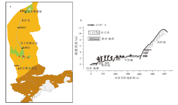
克里雅河位于塔克拉玛干沙漠南缘,发源于昆仑山主峰乌什腾格山的北坡,向北注入塔克拉玛干沙漠腹地。河流总长860 km(包括古河道90 km),流域总面积3.95×10⁴km2。地势南高北低,由北到南,沉积物明显分异为4个地带,即沙漠、戈壁、亚砂土丘陵以及黄土分布区[17],本文研究区属于河流入沙漠段。气候属暖温带大陆性气候,年降水量44.7 mm,多年平均气温11.6℃,克里雅河两岸风沙地貌发育广泛,洪水季节和枯水季节交替,河流-沙漠过渡带风水交互作用比较典型,经常因季节性洪水河流而改道。
克里雅河样品采集于2013年8月初,将克里雅河自上游至下游选择4个典型河段[18],依次为KR01(克里雅水文站,上中游)、KR02(尧干托格拉克,中游)、KR03(米萨来,下游)、KR04(达里雅博依,尾端),分别对4个横断面进行地形测量(图1a),以断面KR02为例(图1b),沿方位27.07°进行断面测量。采集河漫滩、低阶地以及高阶地的表层(0~5 cm)样品,其中,阶地上沙丘样品采集于丘顶,为风成沙样。每个样品采集500~1 000 g,共采集样品93个,包括断面样品60个,其它样品33个。
图1 克里雅河流域断面采样点(a)及断面(b)位置示意图
Fig. 1 The location of the Keriya River and sampling sites
样品测试在北京师范大学地表过程与资源生态国家重点实验室完成,采用Mastersize2000激光粒度仪分析粒度。根据累积曲线以及Folk和Ward公式,图解计算粒度参数(平均值Mz,分选系数δ1、偏度SK1和峰度KG)。
化学元素测定在中国科学院寒区旱区环境与工程研究所沙漠与沙漠化重点实验室完成,采用的Axios型顺序式波长色散型X射线荧光光谱仪,元素测定误差<5%。主量元素以氧化物百分含量表示,微量元素以ug/g表示其含量。文中氧化物的比值以及风化参数的计算均以摩尔质量百分比代入。
矿物成熟度指数(M=SiO2/K2O+Na2O+Al2O3),是判别砂岩或其他碎屑岩在化学上及矿物学上成熟度高低的一个指数[19]。 化学蚀变指数(CIA)作为一个判断源区化学风化程度的化学指标被广泛应用,表达式通常表示为:CIA=[Al2O3/(Al2O3+CaO*+Na2O+K2O]×100,主成分均指摩尔分数[20,21] ,CaO*指的是硅酸盐矿物中的Ca含量,不包括碳酸盐和磷酸盐等矿物中结合的Ca,本文采用采用McLennan提出的校正方法[22]计算。成分变异指数(Index of Compositional Variability, ICV)沉积物中矿物化学风化程度,ICV =(Fe2O3 +K2O +Na2O +CaO +MgO +MnO +TiO2)/Al2O3[23]。残积系数(R)为( Al2O3 + Fe2O3) /( CaO + MgO + Na2O),反映化学风化作用强弱[24]。淋溶系数(β):氧化硅与钙、镁、钾、钠氧化物的分子比。 风化淋溶指数(ba):钙、镁、钾、钠氧化物与氧化铝的分子比。 富集因子(EF):富集因子作为表征沉积物中元素含量相对于地壳中含量的富集程度指标,由于铝元素在风化过程中保留在风化残留物质中,是主要元素中最不活泼的元素之一。因此,常采用相对于元素A1的“元素比值”来表示元素的化学活动性[25,26]。
从粒度组成来看(表1),克里雅河样点的粒径组成以极细砂所占比例最高,占到近一半,其次为粉砂与细砂含量,各占1/4左右,三者共占到95%左右。粘土以及中粗砂含量较少,不到10%。自上游至下游,粒度组成没有明显的递变规律,以河流尾闾段(KR04)的粉砂含量较高,极细砂及细砂含量偏低,平均粒径偏细,分选性较差,其它3个断面之间粒度组成差异较小。综上,不同河段砂物质来源多为就地起砂,与河流流向没有直接的关系。下游尾闾段,河流作用微弱,风力作用强盛,物质来源复杂,分选性较差。
表1 克里雅河及其断面的颗粒物组成平均含量与平均粒度参数
Table 1 The grain size average content, grain size parameters of total and reaches in surface sediments of the Keriya River
| 断面 | 各粒级含量(%) | Mz(Φ) | δ1(Φ) | SK1 | KG | |||||
|---|---|---|---|---|---|---|---|---|---|---|
| 粘土 | 粉砂 | 极细砂 | 细砂 | 中砂 | 粗砂 | |||||
| KR01 | 0.288 | 21.323 | 49.529 | 24.322 | 4.036 | 0.503 | 3.409 | 0.773 | 0.023 | 1.085 |
| KR02 | 0.124 | 17.673 | 50.487 | 28.675 | 2.797 | 0.245 | 3.34 | 0.690 | 0.029 | 1.028 |
| KR03 | 0.137 | 20.056 | 48.759 | 24.059 | 5.438 | 1.551 | 3.32 | 0.760 | -0.006 | 1.020 |
| KR04 | 2.150 | 38.245 | 30.840 | 21.625 | 6.385 | 0.756 | 3.94 | 1.120 | 0.082 | 1.073 |
| 全部样品平均 | 0.699 | 25.640 | 44.17 | 23.550 | 4.640 | 0.760 | 3.515 | 0.871 | 0.065 | 1.105 |
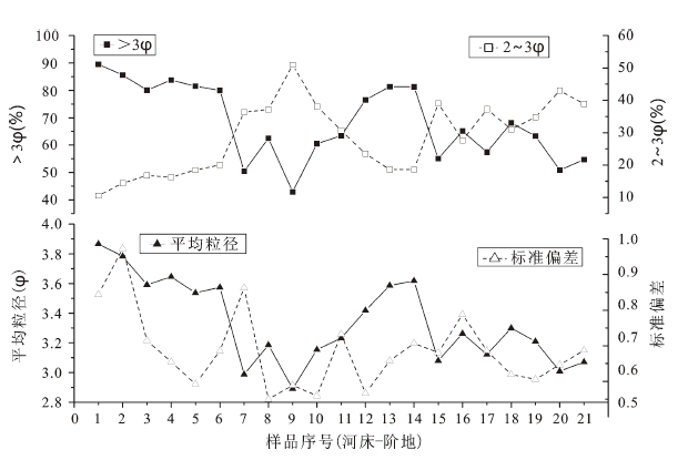
选择断面KR02来看不同地貌单元粒度分布特征,从图中可以看出(图2),自河床至阶地,>3 φ粒径含量递减,2~3 φ粒径含量递增,平均粒径与标准偏差均递减,表明自河床至阶地沙丘砂,粒径变粗,分选变好。在不同地貌单元变化为,自河床→河漫滩→低阶地→高阶地,对应>3 φ变化为递减→递增→递减至稳定,而2~3 φ含量与其相反,呈现递增→递减→递增至稳定。同样,前者与平均粒径、标准偏差的递变趋势一致,即自河床至河漫滩,颗粒变粗,分选性变好。自河漫滩至低阶地,粒径变细,分选变差。低阶地至高阶地粒径变粗,分选性变好。其中,以高阶地的粒径组成及分选性最稳定,地貌的过渡阶段,波动较大。究其原因,自河床至低阶地,其物源受河流自源头搬运新物质的混入,物源上的复杂性,使得粒度特征上兼有风成、水成沉积物特性,波动较大。高阶地沉积物主要受下伏沙丘的影响,多为就地起沙,经风力长期筛选作用,细颗粒物质被吹蚀,颗粒组成变粗,但分选性较好,表现为稳定的风成特点。
图2 克里雅河断面(KR02)粒度组成与粒度参数分布
Fig.2 The grain size components and parameters of the Keriya River section
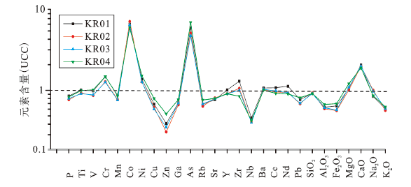
不同河段常量氧化物与上陆壳(UCC)标准线相比(图3),除Co、As、Cr、Zr以及Ca富集外均处于亏损状态,4个断面元素变化曲线的递变趋势,以KR04与其它断面差异较大,表明不同河段沉积物可能具有相同的物源,但经后期差异性风化过程又表现出一定分异性,尤其对下游尾闾段KR04。
图3 克里雅河断面元素UCC标准化值分布
Fig.3 UCC of element patterns for different reaches of the Keriya River
断面内不同地貌类型常量元素的空间分布结果表明(图4),自河漫滩至低阶地,Si、Na、K递增,Ca、Mg、Fe递减,这一方面与河漫滩砂样继承了河床来自上游母岩中石英含量少而角闪石、赤铁矿、钦铁矿、绿泥石等含量高有关,但脱离河床后在表生作用中,不稳定的暗色矿物被浅色矿物彻底取代,导致Ca、Mg、Fe等成分明显流失。另一方面也可能受粒度差异的影响,即颗粒较粗砂样含较多Si及不稳定矿物或元素。自低阶地至次级阶地,则表现出相反的规律,即Si、Na、K递减,Ca、Mg、Fe递增,这与距离河床较远,水分减少,不稳定矿物反而富集。自次级阶地至高阶地,则Si、Na、K、 Ca、Mg、Fe均递减至稳定,这一方面可能受阶地下伏沉积物矿物含量的影响,其次可能与风化时间有关,即高阶地物质长期经历风力搬运引起矿物流失,因此,年代越老的沙丘沉积,不稳定矿物含量愈少。
图4 克里雅河断面(KR02)不同地貌单元的元素富集因子空间分布
Fig.4 The distribution of element enrichment factor of the Keriya River section
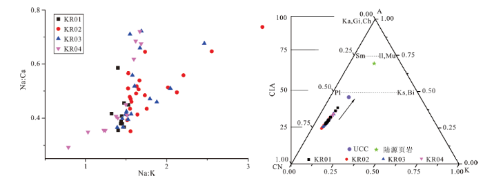
从Na∶K与Na∶Ca散点图来看(图5a),不同河段的沙物质混杂分布,除断面KR01外,其它断面数据点分布较为分散,表明不同河段样点化学风化过程存在相似性,化学风化程度总体较弱,但不同样点化学风化程度存在差异性,分布上呈现出不均衡。A-CN-K模型被广泛用于反映化学风化趋势以及化学风化过程中主成分和矿物学变化[27,28]。UCC指向陆源原岩(PAAS)代表了典型的大陆风化趋势。从不同河段的A-CN-K图来看(图5b),4断面样点沿着UCC风化趋势线呈重叠分布,且样点连线几乎平行于A-CN线,表明流域内沉积物经历相似的地球化学过程,且在化学风化趋势上具有高度一致性,即风化程度均向着递增趋势发展。4个断面样品值远低于UCC以及CIA指数均小于50,说明不同河段样点均处在未受或较弱的大陆化学风化的初级阶段[29,30],即较弱的去Na、Ca阶段,其它元素变化较少。
图5 克里雅河不同河段化学风化参数散点图(a)与A-CN-K三相图(b)
Fig. 5 The scatter plot chemical weathering index and A-CN-K ternary diagram for different reaches of the Keriya River
(A=A12O3,C=CaO,N=Na2O,K=K2O,F=Fe2O3,M=MgO,CaO-硅酸盐矿物中的摩尔含量,Pl-斜长石,Ks-钾长石,Sm-蒙脱石,IL-伊利石,Mu-白云母,Ka-高岭石,Fs-长石)
从矿物成熟度指数(M)与化学风化指数来看(图6),矿物成熟度指数在3.5~4.5之间,自河床至阶地总体呈波动上升趋势,淋溶系数递增,风化淋溶指数递减,表明化学风化程度增强,且河床至低阶地段与高阶地段发生突变,存在明显的界限。化学风化指数以低阶地波动较大,高阶地最稳定。其原因在于,自河漫滩至低阶地,沙源主要来自于现代河床物质,化学风化作用减弱,且较不稳定,而高阶地沉积物与下伏古沙丘有关,与现代河流关系较小,其化学风化程度较强。
图6 克里雅河断面矿物成熟度(a)与化学风化指数(b)
Fig.6 The mineral maturity(a) and chemical weathering index(b) of the Keriya River section
通过对克里雅河不同河段以及不同地貌单元的粒度特征、化学元素的分析,得出以下主要结论:
1)克里雅河地表沉积物的粒度组成以>2φ的粒径为主,粒度分选性处于中等水平,峰态上多为近对称的窄峰,总体特征上表现出风成的特点;不同河段之间,粒度的组成及分布特征,以河流尾闾段与其它断面差异较大;不同地貌单元自河漫滩至阶地,粒度变粗,分选性变好;河漫滩至低阶地段与高阶地段粒度特征递变规律相反。
2)克里雅河的不同河段,沉积物处在未受或较弱的大陆化学风化的初级阶段,自河漫滩至低阶地,化学风化程度增强。河漫滩至低阶地段与高阶地之间有着明显的界限,且以前者波动较大,后者较稳定。
3)克里雅河地表沉积物化学风化指数与粒径大小存在一定的相关性,粒度特征与化学元素风化过程二者之间存在相互影响、相互作用的关系。
控制沉积物组成的因素主要包括原岩、构造及气候、沉积地形等[31,32],在不同的空间尺度上控制影响粒度特征或化学风化的关键因素不同。物源与气候因素是影响流域地表沉积物特征的关键因素。流域内沉积物特征表现出一定的均一化,表现在不同河段沙样,从粒度组成以及化学元素含量很难做出严格区别,这一方面说明不同河段沙样具有同源性,即由发源于昆仑山的河流把岩石风化产物搬至沙漠腹地,再经风力搬运混合,从而在理化特征上表现出一致性。另一方面后期环境的改造作用的差异又使其具有一定的特殊性,如下游河流尾闾段,流水作用微弱,风力作用较强,化学风化程度较弱。但在风力作用下受到明显机械改造,产生高度分选和混合,因而在粒度特征上表现为粒度相对较粗,分选性较好,峰态较窄,明显表现出风成的特征。对于不同地貌单元,随着距离河流远近不同以及局地地貌差异,引起物源以及水分差异,从而导致不同地貌单元的样点粒度分布以及化学元素风化特征呈现出不同的递变规律。因此,在不同空间尺度上,沉积物理化特征上的差异除物源影响之外,实质上反映风动力和水动力的差异性分选,不同空间尺度上,表现不一。因此,如何确定风、水动力对沉积物特征上的贡献率问题,进而构建风水两相沉积物综合判别指标等问题是未来研究的要点所在。
The authors have declared that no competing interests exist.
| [1] |
Fluvial-aeolian interactions:Part I Modern systems [J]. |
| [2] |
Response of eolian geomorphic systems to minor climate change:Examples from the southern Californian deserts [J].https://doi.org/10.1016/S0169-555X(97)00018-4 URL 摘要
At both time scales, eolian activity in southern Californian deserts is strongly controlled by variations in precipitation. Wind energy is not a limiting factor in this region. Formation of eolian deposits is a product of climatic changes that increase sediment supply from fluvial and lacustrine sources and may, therefore, be closely tied to periods of channel cutting and geomorphic instability. During intervening periods, eolian deposits migrate away from sediment source areas and are reworked, modified, and degraded. Remobilization of existing dormant dunes is a product of reduced vegetation cover and soil moisture in periods of drier climates. The major control on these processes is decadal to annual changes in rainfall that determine vegetation cover and soil moisture content.
|
| [3] |
Aeolian-fluvial interactions in dryland environments:examples,concepts,and Australia case study [J].https://doi.org/10.1191/0309133303pp386ra URL [本文引用: 1] 摘要
: Over the past 10 to 15 years there has been a rising interest in interactions between aeolian and fluvial processes from geomorphologists and sedimentologists. This reflects recognition of the limitations of a reductionist perspective examining single process systems in understanding landform and landscape development. This paper focuses on the rise of aeolian070705fluvial interaction research in dryland environments. Wefirst explore the background to the contemporary situation then review existing research on aeolian070705fluvial interactions at global/regional and local scales. From this review it is suggested that landscape sensitivity, or the effectiveness of links between the process systems, spatial environmental transitions and temporal environmental change are the three main driving forces determining the geomorphological significance of aeolian070705fluvial interactions. The importance of the first two of these driving forces is explored in more detail using Australia as a case study. We conclude by highlighting some future possible research directions in this field.
|
| [4] |
Interactions between aeolian and fluvial systems in dryland environments [J].https://doi.org/10.1111/1475-4762.00052 URL [本文引用: 1] 摘要
Historically, fluvial and aeolian processes in dryland environments have been viewed as mutually exclusive. However, recent research indicates that in many regions dryland aeolian and fluvial systems do not operate independently. There are interactions between the two systems that have important implications for the geomorphology of the landscape. This paper reviews the factors controlling the transfer of sediments between aeolian and fluvial systems, focusing on moisture availability, sediment supply and the magnitude/frequency characteristics of fluvial and aeolian events. We conclude by highlighting areas of future research that will contribute greatly to our understanding of aeolian鈥揻luvial relationships in dryland areas.
|
| [5] |
land degradation in drylands:interactions among hydrologic-aeolian erosion and vegetation dynamics [J].https://doi.org/10.1016/j.geomorph.2009.11.023 URL 摘要
Land degradation in drylands is one of the major environmental issues of the 21 st century particularly due to its impact on world food security and environmental quality. Climate change, shifts in vegetation composition, accelerated soil erosion processes, and disturbances have rendered these landscapes susceptible to rapid degradation that has important feedbacks on regional climate and desertification. Even though the role of hydrologic-aeolian erosion and vegetation dynamic processes in accelerating land degradation is well recognized, most studies have concentrated only on the role of one or two of these components, and not on the interactions among all three. Drawing on relevant published studies, here we review recent contributions to the study of biotic and abiotic drivers of dryland degradation and we propose a more holistic perspective of the interactions between wind and water erosion processes in dryland systems, how these processes affect vegetation patterns and how vegetation patterns, in turn, affect these processes. Notably, changing climate and land use have resulted in rapid vegetation shifts, which alter the rates and patterns of soil erosion in dryland systems. With the predicted increase in aridity and an increase in the frequency of droughts in drylands around the world, there could be an increasing dominance of abiotic controls of land degradation, in particular hydrologic and aeolian soil erosion processes. Further, changes in climate may alter the relative importance of wind versus water erosion in dryland ecosystems. Therefore acquiring a more holistic perspective of the interactions among hydrologic-aeolian erosion and vegetation dynamic processes is fundamental to quantifying and modeling land degradation processes in drylands in changing climate, disturbance regimes and management scenarios.
|
| [6] |
Effects of river regulation on aeolian landscapes,Colorado River,southwestern USA [J].https://doi.org/10.1029/2011JF002329 URL 摘要
Connectivity between fluvial and aeolian sedimentary systems plays an important role in the physical and biological environment of dryland regions. This study examines the coupling between fluvial sand deposits and aeolian dune fields in bedrock canyons of the arid to semiarid Colorado River corridor, southwestern USA. By quantifying significant differences between aeolian landscapes with and without modern fluvial sediment sources, this work demonstrates for the first time that the flow- and sediment-limiting effects of dam operations affect sedimentary processes and ecosystems in aeolian landscapes above the fluvial high water line. Dune fields decoupled from fluvial sand supply have more ground cover (biologic crust and vegetation) and less aeolian sand transport than do dune fields that remain coupled to modern fluvial sand supply. The proportion of active aeolian sand area also is substantially lower in a heavily regulated river reach (Marble-Grand Canyon, Arizona) than in a much less regulated reach with otherwise similar environmental conditions (Cataract Canyon, Utah). The interconnections shown here among river flow and sediment, aeolian sand transport, and biologic communities in aeolian dunes demonstrate a newly recognized means by which anthropogenic influence alters dryland environments. Because fluvial-aeolian coupling is common globally, it is likely that similar sediment-transport connectivity and interaction with upland ecosystems are important in other dryland regions to a greater degree than has been recognized previously.
|
| [7] |
中国北方地区沙漠与河流景观格局 [J].https://doi.org/10.11820/dlkxjz.2014.09.007 Magsci [本文引用: 1] 摘要
本文运用景观生态学原理,借助ArcGIS技术,选择中国北方10 个流域及其12 个沙漠/沙地,并以西部的和田河和东部的西辽河为典型研究区,在流域与沙区、河道与沙丘两个尺度上,选取景观破碎度指数、景观多样性指数等指标,探讨中国北方干旱、半干旱区沙漠/沙地景观与廊道景观(河流)的空间镶嵌格局特征。结果表明:在流域与沙区尺度上,内流区较外流区沙区景观类型复杂,景观破碎度较小,外流区沙区景观结构较为相似;内流区沙区景观指数自西向东呈现出“景观破碎度递增、景观结构复杂性递减”的规律。在河道与沙丘尺度上,在缓冲带范围内,和田河较西辽河沙丘景观类型复杂,景观破碎度较小;景观指数随河道距离的变化呈现出“景观破碎度随距河道距离的加大而逐渐递减,丰富度指数随距河道距离的加大而呈阶梯状递增”的规律;从沙丘斑块类型景观指数上看,西辽河以固定、半固定的简单型沙丘为主,和田河以流动的综合型沙丘为主。主导的沙丘类型景观距离河道越远,面积比例越小,不同沙丘类型的水平景观破碎度随河道距离递减。
Landscape pattern characteristics of deserts and rivers in Northern China. https://doi.org/10.11820/dlkxjz.2014.09.007 Magsci [本文引用: 1] 摘要
本文运用景观生态学原理,借助ArcGIS技术,选择中国北方10 个流域及其12 个沙漠/沙地,并以西部的和田河和东部的西辽河为典型研究区,在流域与沙区、河道与沙丘两个尺度上,选取景观破碎度指数、景观多样性指数等指标,探讨中国北方干旱、半干旱区沙漠/沙地景观与廊道景观(河流)的空间镶嵌格局特征。结果表明:在流域与沙区尺度上,内流区较外流区沙区景观类型复杂,景观破碎度较小,外流区沙区景观结构较为相似;内流区沙区景观指数自西向东呈现出“景观破碎度递增、景观结构复杂性递减”的规律。在河道与沙丘尺度上,在缓冲带范围内,和田河较西辽河沙丘景观类型复杂,景观破碎度较小;景观指数随河道距离的变化呈现出“景观破碎度随距河道距离的加大而逐渐递减,丰富度指数随距河道距离的加大而呈阶梯状递增”的规律;从沙丘斑块类型景观指数上看,西辽河以固定、半固定的简单型沙丘为主,和田河以流动的综合型沙丘为主。主导的沙丘类型景观距离河道越远,面积比例越小,不同沙丘类型的水平景观破碎度随河道距离递减。
|
| [8] |
|
| [9] |
Fluvio-aeolian dynamics in the north-eastern Sahara:the relationship between fluvial/aeolian systems and ground-water concentration [J].https://doi.org/10.1006/jare.1999.0581 URL 摘要
The relationship between sand accumulation and groundwater resources in the title area is summarized and the link between aeolian activity and the palaeo-fluvial landscape is described. Radar images showed the spatial organization of palaeo-channels, the localization of main sand areas in topographic depressions. During periods of drier climates, the fluvially deposited sand was reshaped by aeo...
|
| [10] |
How dry was dry?-Late Pleistocene palaeoclimates in the Namib Desert [J].https://doi.org/10.1016/S0277-3791(01)00126-3 URL [本文引用: 1] 摘要
Evidence for Late Quaternary changes in climate in the Namib Desert is geographically scattered and often poorly dated. The available evidence suggests periods of increased river discharge and groundwater flow centered on 8–12, 20–24, and 26–3202ka02BP. Based on modern analogues, these palaeohydrologic changes likely involved increased rainfall and runoff in the escarpment zone east of the desert. There is little evidence to suggest significantly increased rainfall within the desert during these periods, except perhaps during the interval prior to 2602ka02BP. These data reinforce earlier conclusions that the Namib has experienced mostly arid to hyperarid conditions throughout the Quaternary.
|
| [11] |
Variation in chemical compositions of the eolian dust in Chinese Loess Plateau over the past 2.5 Ma and chemical weathering in the Asian inland [J].https://doi.org/10.1007/BF02909779 URL [本文引用: 1] 摘要
Major and trace elements as well as strontium isotopiccomposition have been analyzed on the acid-insoluble (AI) phase of the loess-paleosol sequence from Luochuan, Shaanxi Province, China. Results show that the chemical composition of AI phase of loess and paleosols is distinctive to the average composition of upper continental crust (UCC), characterized by depletion of mobile elements Na, Ca and Sr. The distribution pattern of elements in AI phase reveals that initial dust, derived from a vast area of Asian inland, has suffered from Na- and Ca-removed chemical weathering compared to UCC. Some geochemical parameters (such as CIA values, Na/K, Rb/Sr and 87Sr/87Sr ratios) display a regular variation and evolution, reflecting that the chemical weathering in the source region of loess deposits has decreased gradually since 2.5 Ma with the general increase of global ice volume. This coincidence reflects that the aridity of Asian inland since the Quaternary is a possible regional response to the global climate change.
|
| [12] |
Statistical empirical index of chemical weathering in igneous rocks: A new tool for evaluating the degree of weathering [J].https://doi.org/10.1016/j.chemgeo.2007.02.017 URL 摘要
Chemical weathering indices are useful tools in characterizing weathering profiles and determining the extent of weathering. However, the predictive performance of the conventional indices is critically dependent on the composition of the unweathered parent rock. To overcome this limitation, the present paper introduces an alternative statistical empirical index of chemical weathering that is extracted by the principal component analysis (PCA) of a large dataset derived from unweathered igneous rocks and their weathering profiles. The PCA analysis yields two principal components (PC1 and PC2), which capture 39.23% and 35.17% of total variability, respectively. The extent of weathering is reflected by variation along PC1, primarily due to the loss of Na
|
| [13] |
Inner Mongolia [J].https://doi.org/10.1016/j.quascirev.2013.02.006 Magsci [本文引用: 1] 摘要
Sedimentary sequences occurring in desert dunes reflect changes in desert systems, and as such may contain signals useful for recognizing spatial and temporal changes of deserts and their response to regional or even global climate fluctuations. Geomorphological and palaeoenvironmental studies within the dune fields of the Asian middle-latitudes have provided some solid evidence for interpreting the history of these sand seas. Using the Hunshandake (Otindag) Sandy Land, a sandy area covered primarily by stabilized dunes and located in the semi-arid zone of eastern Inner Mongolia, China (Fig. 1), as an example, we studied the initiation and variation in the dune landscape in the eastern portion of the desert belt in northern China. On the basis of physical and biochemical indicators in the sediments and OSL chronology, we herein argue that this dune system in the middle latitudes of eastern Asia is much younger than previously assumed and that it has responded sensitively to climate change during the late Quaternary. Geological evidence from the Sandy Land suggests that most of the current dunes are of late Pleistocene or even Holocene age. Palaeosols intercalated in the aeolian sequences and their OSL chronology show that the climate of the Hunshandake was much wetter than today between 9.6 ka and 3 ka. This resulted in stabilization of the dunes in the eastern and central portions of the Sandy Land. Epochs of reworking or stabilization of the dunes are broadly consistent with the fluctuations in northern hemisphere solar radiation although with an obvious time lag. Because the increase rate of annual precipitation was not sufficient to fully stabilize the dunes in more arid part of the region, some active dunes persisted even during this long-lasting wetter epoch. We conclude that periods of Holocene dune stabilization due to palaeosol formation varied along the climate gradients across the various sandy lands of northern China, and in general it began earlier and lasted longer in the east than in the west. The general nature of the sandy lands and their counterparts in the western portion of the desert belt during the LGM and mid-Holocene climate optimum is discussed in comparison with their current states. (C) 2013 Elsevier Ltd. All rights reserved.
|
| [14] |
Petro Genesis of sediments in the absence of chemical weathering:effects of abrasion and sorting on bulk composition and mineralogy [J]. |
| [15] |
库姆塔格沙漠地表物质组成、来源和风化过程 [J].Magsci 摘要
<p>通过对库姆塔格沙漠地表沉积物样品进行重矿物和主量元素分析,获得了其矿物和元素组成特征:矿物种类多,绿帘石和角闪石含量为主;化学组成上以Si、Al为主,和上陆壳平均化学组成相比,除Si、Ca外都有一定的亏损,Fe、Mg、Ca、P、Ti、Mn等元素的变异系数较高。库姆塔格沙漠地表沙物质组成特征与阿尔金山北麓出露的岩石和冲、洪积扇物质组成基本一致,与塔克拉玛干沙漠也有很大的共性,反映了库姆塔格沙漠地表沙物质主要来源于阿尔金山。沙漠北区强烈的东北风将阿奇克谷地和疏勒河下游的河湖相沉积物搬运至沙漠腹地,构成另一个重要的沙物质来源。A-CN-K图解揭示了库姆塔格沙漠地表物质化学风化程度很低,处于较弱的去Na、Ca阶段,其他元素未发生明显的化学风化或迁移;A-CNK-FM图解表明,库姆塔格沙漠地表物质在搬运、沉积过程中Fe、Mg等元素发生显著分异,其原因主要是铁镁质矿物由于磨损、分选作用遭破碎和风化,使粒度较粗的沙漠沙Fe、Mg等元素相对亏损。</p>
Composition,origin and weathering process of surface sediment in kumtagh desert,northwest China. Magsci 摘要
<p>通过对库姆塔格沙漠地表沉积物样品进行重矿物和主量元素分析,获得了其矿物和元素组成特征:矿物种类多,绿帘石和角闪石含量为主;化学组成上以Si、Al为主,和上陆壳平均化学组成相比,除Si、Ca外都有一定的亏损,Fe、Mg、Ca、P、Ti、Mn等元素的变异系数较高。库姆塔格沙漠地表沙物质组成特征与阿尔金山北麓出露的岩石和冲、洪积扇物质组成基本一致,与塔克拉玛干沙漠也有很大的共性,反映了库姆塔格沙漠地表沙物质主要来源于阿尔金山。沙漠北区强烈的东北风将阿奇克谷地和疏勒河下游的河湖相沉积物搬运至沙漠腹地,构成另一个重要的沙物质来源。A-CN-K图解揭示了库姆塔格沙漠地表物质化学风化程度很低,处于较弱的去Na、Ca阶段,其他元素未发生明显的化学风化或迁移;A-CNK-FM图解表明,库姆塔格沙漠地表物质在搬运、沉积过程中Fe、Mg等元素发生显著分异,其原因主要是铁镁质矿物由于磨损、分选作用遭破碎和风化,使粒度较粗的沙漠沙Fe、Mg等元素相对亏损。</p>
|
| [16] |
距今30 Ka前后我国西北沙漠地区古环境. 第四纪研究 [J],Palaeoenvironments in desert regions of northwest China around 30 ka B.P. |
| [17] |
Late quaternary palaeoenvironment change and landscape evolution along the keriya river,Xinjiang,China: the relationship between high mountain glaciation and landscape evolution in foreland desert regions [J].https://doi.org/10.1016/S1040-6182(02)00061-7 URL [本文引用: 1] 摘要
正The sedimentology and geomorphology of landforms along Keriya River,that traverse the Kunlun Mountains and Taklamakan Desert,were studied to examine the relationship between environmental change and landscape evolution in mountains and desert margins of the Taklamakan Desert.The region is divided into four geomorphic provinces:desert with active dunes and sand seas; desert pediment with fans;and foothills with deep gorges and glaciated mountains.A succession of three fans with dunes is differentiated on the basis of morphostratigraphy and relative weathering. The oldest fan and dunes are radiocarbon dated to~29 ka.This fan probably formed as a response to increased meltwater and sediment loads as glaciers retreated at the end of the local last glacial maximum in the Kunlun Mountains.Periglacial and glacial features throughout the region show that, during the last glacial,the snowline was lowered to~4000m a.s.l.,permafrost existed down to an altitude of~1800m a.s.l.,and that the likely temperature depression was~10℃.Radiocarbon dates on sand dunes and tamarisk hills help dune the age of the lower two terraces to1.5 ka and a few hundred years BR This suggests that these terraces may have formed in response to increased precipitation during more humid times at~2 ka and during the Little Ice Age,respectively.The landforms and sediments in this region are polygenetic in origin,being transported,eroded and deposited by glacial,fluvial,aeolian and lacustrine processes.Particle size characteristics show that the fluvial sediments were substantially modified down basin.In contrast,the aeolian sediments were modified as they were transported toward the mountains from the desert by the dominant northerly winds.This complex interaction between environmental change and earth surface processes provides an important framework for examining the environmental consequences of the recently growing population and intensified agricultural activities along the mountain and desert margins of the Taklamakan Desert.
|
| [18] |
|
| [19] |
Mineralogical maturity in dune fields of North America, Africa and Australia [J]. |
| [20] |
Early proterozoic climates and plate motions inferred from major element chemistry of lutites [J].https://doi.org/10.1038/299715a0 URL [本文引用: 1] 摘要
The early Proterozoic Huronian Supergroup of the north shore of Lake Huron (Fig. 1) is a thick (up to 12,000 m) succession of sedimentary and volcanic rocks deposited between about 2,500 and 2,100 Myr ago. Here we present a palaeoclimatic interpretation of the Huronian based on approximately 200 major elements analyses of lutites. Most of these are new analyses from the Gowganda and Serpent Formations (Fig. 2). The remainder are from published sources cited in Fig. 4. The composition of lutites from the Huronian Supergroup records an early period of intense, probably tropical, weathering followed by climatic deterioration that culminated in widespread deposition of glaciogenic sediments of the Gowganda Formation. Climatic amelioration followed during deposition of the succeeding Huronian formations. The Huronian succession can be interpreted using a uniformitarian approach in that present day seafloor spreading rates and latitude-related climatic variations are compatible with available geochronological and palaeomagnetic data.
|
| [21] |
化学蚀变指数(CIA)及其在新元古代碎屑岩中的应用 [J].https://doi.org/10.3321/j.issn:1005-2321.2003.04.019 URL [本文引用: 1] 摘要
化学蚀变指数(CIA)首先是作为一个判断源区化学风化程度的化学指标被广泛应用的,它的表达式通常表示为:CIA= {x(Al2O3)/[x(Al2O3)+x(CaO*)+x(Na2O)+x(K2O)]}×100,主成分均指摩尔分数,CaO*仅为硅酸盐中的 CaO.利用CIA分析湖南石门杨家坪剖面的新元古代地层,发现冰期沉积物(南沱组、东山峰组)的CIA值(60~70)和间冰期沉积物(湘锰组)CIA 值(70~75)分别反映了冰期和间冰期的化学风化特点,并且根据渫水河组CIA值(55~70)可以判断渫水河组可能也是冰期的沉积产物.另一方面,可 以利用A-CN-K图解判断沉积岩源岩成分,因为样品点在三角图解中投影点的趋势线与Pl-Ksp连线的交点代表的是源岩斜长石和钾长石的比率.据此初步 判断渫水河组源岩成分是南秦岭-扬子地区元古宙TTG岩石.此外,钾交代作用在前寒武纪普遍发育,在A-CN-K图解中表现为样品点的趋势线向右偏离预测 的风化趋势线,渫水河组的样品点就表现出这样的特征,可以判断渫水河组钾交代作用发育.样品的选取是进行CIA研究的一个重要的步骤.首先样品的岩性最好 是细屑岩,这样可以排除分选作用对源岩成分的改造;其次,需要考虑去除成岩作用过程中加入的K2O;再次,利用ICV这个化学指标来判断沉积再循环作用对 沉积物成分的改造,ICV大于1意味着沉积再循环作用的影响很小,所以选取ICV大于1的细屑岩样品作为我们的研究对象.
CIA ( Chemical index of ateration) and its appijications in the neoproterozoic clastic rocks. https://doi.org/10.3321/j.issn:1005-2321.2003.04.019 URL [本文引用: 1] 摘要
化学蚀变指数(CIA)首先是作为一个判断源区化学风化程度的化学指标被广泛应用的,它的表达式通常表示为:CIA= {x(Al2O3)/[x(Al2O3)+x(CaO*)+x(Na2O)+x(K2O)]}×100,主成分均指摩尔分数,CaO*仅为硅酸盐中的 CaO.利用CIA分析湖南石门杨家坪剖面的新元古代地层,发现冰期沉积物(南沱组、东山峰组)的CIA值(60~70)和间冰期沉积物(湘锰组)CIA 值(70~75)分别反映了冰期和间冰期的化学风化特点,并且根据渫水河组CIA值(55~70)可以判断渫水河组可能也是冰期的沉积产物.另一方面,可 以利用A-CN-K图解判断沉积岩源岩成分,因为样品点在三角图解中投影点的趋势线与Pl-Ksp连线的交点代表的是源岩斜长石和钾长石的比率.据此初步 判断渫水河组源岩成分是南秦岭-扬子地区元古宙TTG岩石.此外,钾交代作用在前寒武纪普遍发育,在A-CN-K图解中表现为样品点的趋势线向右偏离预测 的风化趋势线,渫水河组的样品点就表现出这样的特征,可以判断渫水河组钾交代作用发育.样品的选取是进行CIA研究的一个重要的步骤.首先样品的岩性最好 是细屑岩,这样可以排除分选作用对源岩成分的改造;其次,需要考虑去除成岩作用过程中加入的K2O;再次,利用ICV这个化学指标来判断沉积再循环作用对 沉积物成分的改造,ICV大于1意味着沉积再循环作用的影响很小,所以选取ICV大于1的细屑岩样品作为我们的研究对象.
|
| [22] |
Weathering and global denudation [J]. |
| [23] |
The influence of sediment recycling and basement composition on evolution of mudrock chemistry in the southwestern United States [J].https://doi.org/10.1016/0016-7037(95)00185-9 URL [本文引用: 1] 摘要
These results confirm the importance of tectonic setting in controlling mudrock chemistry, and also demonstrate that there is a dynamic relationship between the tectonic evolution of a continental block and the composition of its sedimentary mantle.
|
| [24] |
“巫山黄土”氧化物地球化学特征与古气候记录 [J].https://doi.org/10.3969/j.issn.1000-3657.2013.01.025 URL [本文引用: 1] 摘要
根据73个“巫山黄土”样品的氧化物测试结果,对“巫山黄土”氧 化物地球化学特征和记录的古气候特征进行了分析和讨论,结果表明:(1)“巫山黄土”主要的化学成分为SiO2、Al2O3、Fe2O3, (SiO2+Al2O3+Fe2O3)的平均含量大于洛川黄土和甘孜黄土,与洛川古土壤接近,小于安徽宣城风积红土和镇江下蜀土;(2)“巫山黄 土”SiO2、Al2O3、Fe2O3、TiO2含量具有随深度逐渐减少,而FeO、CaO、Na2O、P2O5含量则呈现逐渐增多的特点;(3)巫山剖 面Fe3+/Fe2+比值变化曲线与全铁含量曲线显示明显的正相关,而与SiO2/(Al2O3+Fe2O3)曲线呈反相关;(4)“巫山黄土”的残积系 数和风化指数由老到新其量值逐渐变小,而退碱系数的量值却是逐渐变大的;(5)“巫山黄土”堆积时该区古气候总体上较北方黄土堆积时要偏暖湿,沉积物遭受 的淋溶及氧化作用强度与洛川古土壤相当,明显强于北方洛川黄土和川西的甘孜黄土,但较安徽的宣称风尘红土和镇江下蜀土要弱.剖面中沉积介质的酸度由下向上 逐渐减弱,碱度加强,表生带所遭受的风化作用强度愈来愈弱,风尘堆积的沉积环境则由开始的较为偏湿润逐渐向偏干凉方向发展.(6)“巫山黄土”堆积时期古 气候演变还具有阶段性特点,以剖面6~6.5 m为界可分为上下两段,下段古气候总体较上段偏温湿,气候冷(干)暖(湿)波动频繁、波动幅度较大,而上段古气候相对较为干冷,气候比较稳定,波动幅度也 较小.
Xiong Deqiang https://doi.org/10.3969/j.issn.1000-3657.2013.01.025 URL [本文引用: 1] 摘要
根据73个“巫山黄土”样品的氧化物测试结果,对“巫山黄土”氧 化物地球化学特征和记录的古气候特征进行了分析和讨论,结果表明:(1)“巫山黄土”主要的化学成分为SiO2、Al2O3、Fe2O3, (SiO2+Al2O3+Fe2O3)的平均含量大于洛川黄土和甘孜黄土,与洛川古土壤接近,小于安徽宣城风积红土和镇江下蜀土;(2)“巫山黄 土”SiO2、Al2O3、Fe2O3、TiO2含量具有随深度逐渐减少,而FeO、CaO、Na2O、P2O5含量则呈现逐渐增多的特点;(3)巫山剖 面Fe3+/Fe2+比值变化曲线与全铁含量曲线显示明显的正相关,而与SiO2/(Al2O3+Fe2O3)曲线呈反相关;(4)“巫山黄土”的残积系 数和风化指数由老到新其量值逐渐变小,而退碱系数的量值却是逐渐变大的;(5)“巫山黄土”堆积时该区古气候总体上较北方黄土堆积时要偏暖湿,沉积物遭受 的淋溶及氧化作用强度与洛川古土壤相当,明显强于北方洛川黄土和川西的甘孜黄土,但较安徽的宣称风尘红土和镇江下蜀土要弱.剖面中沉积介质的酸度由下向上 逐渐减弱,碱度加强,表生带所遭受的风化作用强度愈来愈弱,风尘堆积的沉积环境则由开始的较为偏湿润逐渐向偏干凉方向发展.(6)“巫山黄土”堆积时期古 气候演变还具有阶段性特点,以剖面6~6.5 m为界可分为上下两段,下段古气候总体较上段偏温湿,气候冷(干)暖(湿)波动频繁、波动幅度较大,而上段古气候相对较为干冷,气候比较稳定,波动幅度也 较小.
|
| [25] |
The geochemistry of Cu,Cd,Zn,Ni and Pb in sediment cores from the continental slope of the Banc d'Arguin(Mauritania) [J].https://doi.org/10.1016/S0278-4343(98)00109-5 URL [本文引用: 1] 摘要
Trace and major elements were measured in sediment cores collected at the shelf and continental slope of the Banc d'Arguin (Mauritania). Most of the sediments have a calcium carbonate content >50% and as a consequence have a low aluminium (<1.5%) and iron (<1.0%) content. The concentrations of the latter two elements increase down slope. Based on the major elemental composition, the sediments seem to be well mixed and concentration gradients are only observed on a spatial distribution. Concentrations of Cu, Cd, Zn, Ni and Pb are low and approximately equal to ''natural background'' values, indicating negligible anthropogenic influences. An exception is Cd for which very high values were found in the northern most part of the research area, close to Nouadhibou. A possible explanation for this high Cd content can be the existence of phosphate rich sediments with a high affinity for Cd. Small increases in the available trace metal concentrations (exchangeable fraction, 0.1 N HCl treated) observed near the sediment surface could be attributed to early diagenetic processes, and not to pollution effects. The inputs from the Saharan dust plume with low trace metal contents, the transport of small particles with higher trace metal content down slope together with the escape of redissolved trace metals from the sediment, and the absence of a supply of metal rich material to the Banc d'Arguin, has created a metal poor environment. There is clear evidence of trace metal redistributions, associated with Mn recycling. Mean enrichment factors, calculated relative to the crustal abundance, show that Zn, Pb and Cd are equal to unity and Cu and Ni below unity. These observations suggest that the Cu and Ni contents in sediments of Banc d'Arguin are depleted relative to the accepted values in the earth crust. The very low trace metal concentrations detected in these sediments can be taken as 'baseline'' values for unpolluted sediments in the global ocean coastal zone.
|
| [26] |
A graphical teehnique for determining major components in a mixed aerosol.I.Descriptive aspects [J].https://doi.org/10.1016/S1352-2310(98)00252-0 URL [本文引用: 1] 摘要
A persistent problem in aerosol science is how best to determine the compositions of the major components in mixed samples. This paper presents a graphical technique for extracting the elemental compositions of the crustal, marine, and general pollution components in large suites of samples from single sites. Log-log scatter diagrams are constructed, with the vertical axis being the X/Al ratios of the samples (where X is an element of interest and Al is the crustal reference element) and the horizontal axis being either Na/Al or Se/Al (where Na and Se are marine and pollution reference elements, respectively). If the crustal component is sufficiently enriched in enough samples, a horizontal "compositional tail" of X/Al will appear at the left-hand end of the plots, with an asymptotic value equal to the ratio in the pure crustal aerosol. If the second component is sufficiently enriched in enough samples, its compositional tail will appear as a 45 degree zone at the right-hand end of the plots. Depending on the choice of component, the asymptotic value of this tail will be the X/Se ratio in the pollution component or the X/Na ratio in the marine component. When the sample set is large enough, compositions of components can frequently be determined to uncertainties of 10% or less. Results for elements in a large suite of aerosol samples from Narragansett, RI, measured by neutron-activation analysis, reveal well-defined compositional tails for most elements and a smooth progression of elements from purely crustal to purely pollution derived. This graphical technique can also be applied to precipitation, provided only that it has been sampled and analyzed in ways that make its data directly analogous to those of aerosol.
|
| [27] |
地球化学组成在不同粒级中的分布特征 [J].
将哈尔滨城市道路表土样品进行粒度分级,测定各粒级组分的常量元素、碳酸盐含量和碳酸盐碳同位素组成。结果显示,常量元素在不同粒级中的变化程度依次为:AlNaSiKCa、MgFeMnPTi;Fe、Mg、Ca、Mn、Ti和P随粒度变细含量逐渐增加,而Si、Na和K元素则相反,Al元素与粒度的关系不清晰。化学风化指标按照以下的顺序受粒级的影响依次增大:CIA、(Al+Fe+Ti+Mn)/(Mg+Ca+K+Na)(CaO+K2O+Na2O)/Al2O3Fe2O3/MgOK2O/Al2O3(CaO+MgO+Na2O)/TiO2。碳酸盐含量在各粒级组分中变化幅度较大,且随着粒度的变细,碳酸盐含量逐渐增加。碳酸盐δ13C值在各粒级组分中的变化幅度较小,与粒级的关系较为复杂。
The Distribution of Geochemical Composition in Different Grain-size Fractions:a Case Study of Road Surface Soils in Harbin City.
将哈尔滨城市道路表土样品进行粒度分级,测定各粒级组分的常量元素、碳酸盐含量和碳酸盐碳同位素组成。结果显示,常量元素在不同粒级中的变化程度依次为:AlNaSiKCa、MgFeMnPTi;Fe、Mg、Ca、Mn、Ti和P随粒度变细含量逐渐增加,而Si、Na和K元素则相反,Al元素与粒度的关系不清晰。化学风化指标按照以下的顺序受粒级的影响依次增大:CIA、(Al+Fe+Ti+Mn)/(Mg+Ca+K+Na)(CaO+K2O+Na2O)/Al2O3Fe2O3/MgOK2O/Al2O3(CaO+MgO+Na2O)/TiO2。碳酸盐含量在各粒级组分中变化幅度较大,且随着粒度的变细,碳酸盐含量逐渐增加。碳酸盐δ13C值在各粒级组分中的变化幅度较小,与粒级的关系较为复杂。
|
| [28] |
镇江下蜀土剖面的化学风化强度与元素迁移特征 [J].
The chemical weathering intensity and element migration features of the Xiashu loess profile in Zhenjiang are studied in this paper.(1)The Xiashu loess profile underwent moderate chemical weathering.It seems that the precipitation is a more important factor than the temperature in controlling the process of the chemical weathering.(2)The major elements such as Si,K,Na,Ca,Mg,Mn and P were migrated and leached,while the elements Fe and Ti were slightly enriched.The migration features of the major elements reveal that the Xiashu loess finished the primary process of chemical weathering characterized by leaching of Ca and Na,and almost reached the secondary process characterized by leaching of K.Except the elements Sr and Ga,other trace elements such as Th,Ba,Cu,Zn,Co,Ni,Cr and V were enriched.It might be caused by both the biogeochemical process and the adsorption of trace elements by clay mineral and organic materials.(3)The difference of element migration down the Xiashu loess profile reveals that the climate was warm and wet at the early-middle stage of the middle Pleistocene.At the end of the middle Pleistocene,it became dry and cool.At the early stage of the Late Pleistocene,the paleoclimate became warm and wet again.As a whole,the paleoclimate generally became drier and cooler in this region from the beginning of the middle Pleistocene.
Chemical weathering intensity and element migration features of the Xiashu loess profile in Zhenjiang, Jiangsu Province.
The chemical weathering intensity and element migration features of the Xiashu loess profile in Zhenjiang are studied in this paper.(1)The Xiashu loess profile underwent moderate chemical weathering.It seems that the precipitation is a more important factor than the temperature in controlling the process of the chemical weathering.(2)The major elements such as Si,K,Na,Ca,Mg,Mn and P were migrated and leached,while the elements Fe and Ti were slightly enriched.The migration features of the major elements reveal that the Xiashu loess finished the primary process of chemical weathering characterized by leaching of Ca and Na,and almost reached the secondary process characterized by leaching of K.Except the elements Sr and Ga,other trace elements such as Th,Ba,Cu,Zn,Co,Ni,Cr and V were enriched.It might be caused by both the biogeochemical process and the adsorption of trace elements by clay mineral and organic materials.(3)The difference of element migration down the Xiashu loess profile reveals that the climate was warm and wet at the early-middle stage of the middle Pleistocene.At the end of the middle Pleistocene,it became dry and cool.At the early stage of the Late Pleistocene,the paleoclimate became warm and wet again.As a whole,the paleoclimate generally became drier and cooler in this region from the beginning of the middle Pleistocene.
|
| [29] |
Mineralogical and sedimentological studies on the taklimakan desert sands [J].https://doi.org/10.1046/j.1365-3091.1998.00202.x URL [本文引用: 1] 摘要
Major-element composition, mineral composition and grain-size distribution have been studied for Quaternary aeolian sediments from the Taklimakan Desert, north-western China, together with the variation of chemical and mineralogical compositions of different grain-size fractions. Aeolian sediments from the Taklimakan Desert have higher ratios of feldspar/quartz and calcite/quartz, finer grain size, poorer roundness of quartz and feldspar grains and lower abundances of frosted quartz, than found in aeolian sediments from other deserts such as the Saudi Arabian Desert. In spite of these immature mineralogical and sedimentological features, the aeolian sediments from the Taklimakan Desert show low regional variations in major-element and mineral compositions and are homogenized. These observations confirm that two processes, glacial activity within surrounding mountains and aeolian activity at the Tarim Basin, are important in the homogenization of the Taklimakan Desert sands. Taklimakan Desert sediments are constantly and effectively supplied from basement rocks in the surrounding mountains by glacial erosion. The supplied sediments are further homogenized by aeolian activity in the desert and are partly blown away, serving as the source of Chinese aeolian loess. Compositional differences are observed between loess (mainly 10–4065 m particles) and the <4565 m fraction of the Taklimakan Desert sediments, as well as between loess and whole rock of the Taklimakan Desert sediments. These observations provide constraints for precise modelling of loess formation, and for assessment of the chemical composition of the upper continental crust based on the chemical composition of aeolian loess.
|
| [30] |
The source and origin of terrigenous sedimentary rocks in the Mesoproterozoic Ui group,southeastern Russia [J]. |
| [31] |
甘肃西峰晚第三纪红粘土的化学组成及化学风化特征 [J].https://doi.org/10.3969/j.issn.1006-6616.2001.02.012 URL [本文引用: 1] 摘要
通过对甘肃西峰红粘土样品的地球化学研究 ,发现其碳酸盐含量较高 ,而Si、Al、Fe等元素含量相对较低。为消除碳酸盐的影响 ,样品经酸溶处理后其化学组成十分均一 ,反映物质来源的一致性。稀土元素以及微量元素分布形式揭示出红粘土与第四纪黄土 -古土壤风成成因的相似性。研究表明 ,红粘土的化学风化尚处于脱Ca、Na为主的早期阶段 ;CIA值和酸不溶物中的Na K比及Rb Sr比参数一致地指示了红粘土化学风化程度高于第四纪的黄土和古土壤 ,反映出晚第三纪以来黄土高原的气候由相对温暖湿润向第四纪逐渐变干变冷演化的总趋势。
https://doi.org/10.3969/j.issn.1006-6616.2001.02.012 URL [本文引用: 1] 摘要
通过对甘肃西峰红粘土样品的地球化学研究 ,发现其碳酸盐含量较高 ,而Si、Al、Fe等元素含量相对较低。为消除碳酸盐的影响 ,样品经酸溶处理后其化学组成十分均一 ,反映物质来源的一致性。稀土元素以及微量元素分布形式揭示出红粘土与第四纪黄土 -古土壤风成成因的相似性。研究表明 ,红粘土的化学风化尚处于脱Ca、Na为主的早期阶段 ;CIA值和酸不溶物中的Na K比及Rb Sr比参数一致地指示了红粘土化学风化程度高于第四纪的黄土和古土壤 ,反映出晚第三纪以来黄土高原的气候由相对温暖湿润向第四纪逐渐变干变冷演化的总趋势。
|
| [32] |
Balogh-Brunstad Z.origin,weathering, and geochemical composition of loess in southwestern Hungary [J].https://doi.org/10.1016/j.yqres.2008.02.001 Magsci [本文引用: 1] 摘要
<h2 class="secHeading" id="section_abstract">Abstract</h2><p id="">Loess geochemistry generally reflects paleo-weathering conditions and it can be used to determine the average composition of the upper continental crust (UCC). In this study, major and trace element concentrations were analyzed on loess samples from southwestern Hungary to determine the factors influencing their chemical compositions and to propose new average loess compositions. All studied loess samples had nearly uniform chemical composition, suggesting similar alteration history of these deposits. Chemical Index of Alteration values (58–69) suggested a weak to moderate degree of weathering in a felsic source area. Typical non-steady state weathering conditions were shown on the Al<sub>2</sub>O<sub>3</sub>–CaO + Na<sub>2</sub>O–K<sub>2</sub>O patterns, indicating active tectonism of the Alpine–Carpathian system during the Pleistocene. Whole-rock element budgets were controlled by heavy minerals derived from a felsic magmatic or reworked sedimentary provenance. Geochemical parameters indicated that dust particles must have been recycled and well homogenized during fluvial and eolian transport processes.</p>
|

/
| 〈 |
|
〉 |

