袁方 , 谢远云, 詹涛
Yuan Fang, Xie Yuanyun, Zhan Tao
中图分类号: P512.2;P531
文献标识码: A
文章编号: 1000-0690(2017)12-1885-09
通讯作者:
收稿日期: 2016-12-6
修回日期: 2017-03-21
网络出版日期: 2017-12-20
版权声明: 2017 《地理科学》编辑部 本文是开放获取期刊文献,在以下情况下可以自由使用:学术研究、学术交流、科研教学等,但不允许用于商业目的.
基金资助:
作者简介:
作者简介:袁方(1992-),女,硕士,主要研究方向为亚洲风尘系统物源示踪。E-mail:535038276@qq.com
展开
摘要
对杜蒙沙地的河流冲积砂、河漫滩泥质粉砂、沙质古土壤和风成沙等不同类型沉积物进行了采样(27组),对这些样品的细颗粒组分(<63 μm)进行了常量元素、微量元素、稀土元素(REE)和Sr-Nd同位素比值等地球化学分析,就杜蒙沙地的化学风化、沉积再循环特征及其对风尘物质的贡献等展开了讨论。结果显示,杜蒙沙地的地球化学组成表现出空间的均一性,低的化学蚀变指数CIA(48~56,平均52)及A-CN-K和A-CNK-FM图解均表明了杜蒙沙地仅遭受了低级的化学风化程度。沙地的成分成熟度较低,大部分河流沉积物表现出初次循环沉积特征,系大兴安岭东侧中酸性岩浆母岩风化剥蚀的产物经嫩江搬运堆积形成;古土壤表现出与河流沉积物相同的初次循环特征,表明古土壤的成土母质是河流沉积物,这与野外地层出露情况一致;风成沙表现出再循环沉积特征,系河流沉积物就地起沙搬运堆积形成。不活动元素比值、REE和Sr-Nd同位素比值等物源判别图解,结合植被和地貌状况,一致表明杜蒙沙地与东北平原中东部的风尘物质没有地球化学亲缘关系,其对该地区(甚至下风向更远地区)的大气风尘的贡献很小。
关键词:
Abstract
In this study, twenty seven sets of the <63 μm fine-grained subsamples from fluvial sand, floodplain muddy silt, sandy paleosoil and aeolian sand, respectively, in Dumeng Sandy Land, were collected and analyzed for major, trace elements and REE as well as Sr-Nd isotopic compositions to evaluate their source-area chemical weathering and sediment recycling, and to infer their contribution to aeolian dust. It can be concluded, based on low values of chemical index of alteration (CIA=48 to 56, mean value of 52), combined with A-CN-K and A-CNK-FM diagrams, that Dumeng Sandy Land was subjected to weak degree of chemical weathering. The relatively high values of index of compositional variability (ICV=0.95 to 1.2, mean value of 1.05) suggest an immature source. It follows from Zr/Sc vs. Th/Sc plot, integrated with CIA vs. WIP and MFW plots that the majority of fluvial sediments are characterized by first-cycle sediment, sourced from weathering-eroding products of intermediate to felsic rocks in eastern Great Xingan Mountains by transportation of NenJiang River and its tributaries. The paleosoils have the identical first-cycle fingerprints to fluvial sediments, suggestive of their soil parent material being fluvial sediments, consistent with field observation. The good sediment recycled signature, however, characterizes aeolian sands, suggesting that these aeolian sands were derived in situ from fluvial sediments. The integrated provenance tracing plots, involving the ratio of immobile elements, REE and Sr-Nd isotopic composition, in combination with vegetation and geomorphy feature, consistently suggest that Dumen Sandy Land bears a poor geochemical affinity with aeolian dust, indicative of its very little contribution to atmospheric dust to the eastern and central NE Plain.
Keywords:
碎屑沉积物在揭示过去地质记录方面具有重大潜力,通过沉积物的地球化学组成,源区古化学风化条件和物质组成特征以及古构造背景等信息得以重建[1]。尽管沉积过程(例如:风化、剥蚀、搬运、沉积和成岩)可能在一定程度上会改变沉积物的初始组成,但沉积物的地球化学组成仍主要受控于其物源已得到广泛共识[2]。因此,沉积物的地球化学组成被广泛用于物源追踪[3,4,5],特别是风尘物源追踪方面[6,7,8,9,10,11]。
风尘物质和源区物质是风尘系统研究的2个端元,而风尘物源追踪将风尘源区物质和沉降区的风尘物质有机结合起来[12]。亚洲风尘系统包括了广大荒漠地区的地表物质,相对于风尘物质,广大风尘源区和潜在源区的地表物质的地球化学组成还没有广泛研究,且已有的亚洲风尘系统研究多集中在中国西部三大内陆盆地及西部和北部的戈壁、沙漠。从风尘系统的角度对东北平原西部松嫩沙地地表物质组成的研究仍很少涉及。
本文就松嫩平原杜蒙沙地的地表沉积物展开地球化学组成研究,旨在:① 建立杜蒙沙地的地表沉积物包括常量元素、微量元素(包括稀土元素)和Sr-Nd同位素在内的地球化学组成特征;② 讨论杜蒙沙地的化学风化程度和沉积再循环特征;③ 分析杜蒙沙地对风尘物质的贡献。将有助于对东北平原西部沙地风尘系统研究更好的理解。
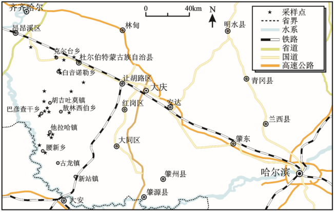
杜蒙沙地是松嫩平原范围最大的一块沙地[13],位于滨州铁路以南,嫩江以东,通让铁路以西,嫩江口以北,平面轮廓呈北宽南窄的三角形(图1)。
杜蒙沙地大体上分为南、北、中3段,北段和南段沙丘较稀疏低矮,中段较密集高大。沙地北段大致沿滨州铁路沿线,包括烟筒屯、泰康、克尔台、一心、靠山,以及大庆市的喇叭甸子等乡镇,多为零散低矮的固定饼状沙丘;沙地中段的北界大致沿汤池—白音诺勒—新店一线,南界沿大山—胡吉吐莫—敖林西伯一线,多为西北—东南向延伸的纵向沙垄;沙地的南段主要在他拉哈、腰新,以及肇源县西部的富强、古龙、新站、茂兴等地,多为零星分布的低缓沙丘。
在杜蒙沙地采集表土样27组,主要为河流冲积砂(样品号分别为:SN2~SN6、SN8~SN12、SN47、SN48、SN54和SN80),其次为风成砂(SN7、SN46、SN50、SN53、SN56、SN58、SN59和SN60),含少许河漫滩相泥质粉砂(SN1、SN57和SN71)和沙质古土壤(SN49和SN55)。采样范围覆盖了杜蒙沙地绝大部分地区(图1),具有广泛的代表性。其中,沙地北段包括样品SN1~SN4、SN71和SN80,中段包括SN5~SN7和SN53~SN60,南段包括SN9~SN12和SN46~SN50。
将样品过250目标准分样筛,获取<63 μm粒级组分的子样,用于地球化学分析。常量元素分析中为避免由于矿物类型或矿物组合的不均匀,造成X射线吸收系数的差异,即矿物效应的影响,采用的是玻璃熔片法,熔片法可基本消除样品均匀与颗粒度的影响,标样制备相对容易[14]。制样后用X射线荧光光谱仪进行测量,测量结果由计算机控制和输出,SiO2分析的绝对误差为±0.5%,Al2O3分析的绝对误差为±0.2%,其他元素分析绝对误差均<0.2%。微量元素和稀土元素是用Finnigan MAT(ElementⅠ)型电感耦合等离子体质谱仪(ICP-MS)完成测试。为了监控测试精度和准确度,进行了国际标样、重复样与空白样品分析,结果表明元素的相对偏差均小于2%。Sr和Nd同位素比值用表面热电离同位素质谱仪测定。将<63 μm的子样用0.5 mol/L 醋酸浸泡4 h,将酸不溶物烘干,研磨至200目,分成2份,分别供Sr(87Sr/86Sr)和Nd(143Nd/144Nd)同位素比值测定。Sr和Nd的分离采用标准离子交换方法。测定的Sr和Nd同位素比值分别用86Sr/88Sr = 0.1194 和146Nd/144Nd = 0.7219进行了标准化处理。本次试验对NBS 987标样测定值为87Sr/86Sr = 0.710 250 ± 7 (2σ),对JMC标样测定值为143Nd/144Nd = 0.512 109 ± 3 (2σ)。化学分析空白:对Sr为<1 ng,对Nd为<50 pg。样品的测试在核工业北京地质研究院分析测试研究中心完成。
通过与UCC和PAAS的元素组成[15] 比较,分析杜蒙沙地的元素地球化学结果。
2.1.1 常量元素
杜蒙沙地的北部、中部和南部表现出均一的常量元素分布。相对于UCC,Fe2O3(3.32%)、MgO(0.81%)、CaO(2.31%)和P2O5(0.11%)明显亏损,Na2O(2.94%)轻微亏损,Al2O3(12.83%)和K2O(2.96%)含量相当或极轻微亏损,MnO(0.08%)和TiO2(0.97%)明显富集,而SiO2(69.72%)含量与UCC一致。
2.1.2 微量元素
杜蒙沙地的过渡元素(TTE:Sc, V, Cr, Co, Ni, Cu, Zn, Ga),与UCC相比,Cr(46.27×10⁻⁶)元素轻度富集,而Sc(7.82×10⁻⁶),Co(8.12×10⁻⁶),Ni(13.66×10⁻⁶),Cu(16.18×10⁻⁶),Zn(49.08×10⁻⁶)元素的含量轻度到中度亏损,V(63.75×10⁻⁶)和Ga(15.97×10⁻⁶)与UCC含量大致相似。对于大离子亲石元素(LILE:Rb, Sr, Cs, Ba, Pb),与上地壳标准含量相比,Rb(91.6×10⁻⁶)和Sr(300×10-6)轻度亏损,Ba(646×10-6)适度或明显富集,Pb(20.2×10⁻⁶)和Cs(4.23×10⁻⁶)与UCC含量相当或轻度富集。对于高场强元素(HFSE:Y, Zr, Nb, Hf, Ta, Th, U),相对于UCC,Zr(331×10-6)和Hf(10.02×10⁻⁶)明显富集,Y(27.95×10⁻⁶)含量相当或稍微富集,Nb(20.73×10⁻⁶)和Ta(1.69×10⁻⁶)含量稍微亏损或相当,Th(15.09×10⁻⁶)和U(2.79×10⁻⁶)含量变化大。
2.1.3 稀土元素
杜蒙沙地的稀土元素总量∑REE为139×10-6~426×10-6(平均值为232×10-6,下同),高于UCC的稀土元素总量(146×10-6)和PAAS的稀土元素总量(185×10-6)。沉积物具有类似PAAS及UCC 的稀土元素配分模式,即轻稀土富集、重稀土亏损、显著Eu负异常的分布模式。LREE/HREE比值为5.57~12.28(10),LaN/YbN为7.33~12.70(10.36)。所有样品都呈现出了明显的Eu负异常(0.42×10-6~0.67×10-6,平均值0.56×10-6),Ce负异常不明显(0.92×10-6~1.04×10-6,平均为0.98×10-6)。
2.1.4 Sr-Nd同位素组成
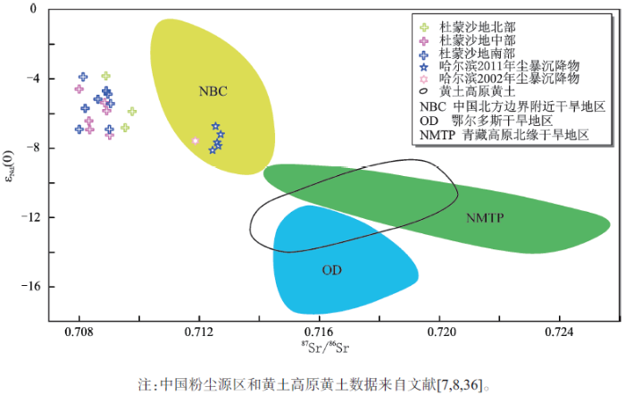
杜蒙沙地的Sr-Nd同位素比值分布相对集中(表1),且北段、中段和南段的同位素比值表现出均一化特征。其中εNd(0)值在-3.84~-7.26(-5.69)之间,而87Sr/86Sr 比值在0.708 008~0.709 775(0.708 756)之间。杜蒙沙地的Sr-Nd同位素组成明显不同于青藏高原北缘干旱地区(NMTP)[8]和鄂尔多斯干旱(OD)[8]地区,而与中国北方边界附近干旱地区(NBC)[8]接近。
表1 杜蒙沙地的Sr-Nd同位素组成
Table 1 Sr and Nd isotopic composition for the Dumeng Sandy Land
| 样品号 | 87Sr/86Sr | 143Nd/144Nd | εNd(0)a |
|---|---|---|---|
| SN1 | 0.7098 | 0.5123 | -5.8911 |
| SN3 | 0.7089 | 0.5124 | -3.8429 |
| SN71 | 0.7095 | 0.5123 | -6.8274 |
| SN5 | 0.7089 | 0.5124 | -5.3839 |
| SN7 | 0.7089 | 0.5123 | -5.8521 |
| SN53 | 0.7080 | 0.5124 | -4.6036 |
| SN54 | 0.7083 | 0.5123 | -6.4373 |
| SN59 | 0.7084 | 0.5123 | -6.9445 |
| SN60 | 0.7090 | 0.5123 | -7.2566 |
| SN8 | 0.7086 | 0.5124 | -5.1888 |
| SN9 | 0.7090 | 0.5124 | -4.8962 |
| SN11 | 0.7081 | 0.5124 | -3.9014 |
| SN12 | 0.7089 | 0.5124 | -4.7012 |
| SN47 | 0.7082 | 0.5123 | -5.7155 |
| SN48 | 0.7090 | 0.5123 | -6.9250 |
| SN49 | 0.7091 | 0.5124 | -5.4424 |
| SN50 | 0.7080 | 0.5123 | -6.9250 |
母岩的化学风化程度在很大程度上影响碎屑沉积物的化学组成,而气候条件和构造活动等因子控制了化学风化程度[16]。在化学风化过程中,稳定元素(如Al,Ti)被保留在风化沉积物中,不稳定元素(如Na,Ca,K,Mg)易流失,而元素的流失程度则由化学风化程度决定[17]。化学蚀变指数CIA[18]被广泛用来定量化学风化程度。CIA定义如下:CIA=100×[Al2O3/(Al2O3+CaO*+Na2O+K2O)],这里的常量元素含量用摩尔浓度表示,CaO*是硅酸盐中的CaO含量。本文使用McLennan[19]提出的校正方法估算硅酸盐组分中的CaO含量:首先消除磷灰石中的CaO,即CaOR= mol CaO–(10/3 × mol P2O5)。假如CaOR ≤ Na2O, 则CaOR值= CaO*;假如CaOR > Na2O,则CaO* = Na2O。杜蒙沙地的CIA值在很窄的范围内变化(48~56,平均52),低CIA值表明了这些沉积物处于化学风化的初级阶段,仅经历了低程度的化学风化。
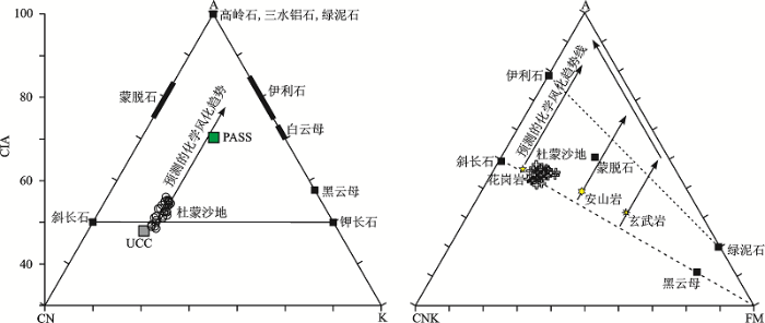
化学风化过程中元素的活动性也能够使用A-CN-K[17,20~22]和A-CNK-FM[21,22]三角图解来评估(图2)。在A-CN-K图解中,除少数样品外,杜蒙沙地样品全部画在斜长石和钾长石连接线的上方,并靠近UCC分布,同时也形成一个平行于A-CN线的线性趋势。这说明杜蒙沙地仅经历了初级的化学风化,化学风化趋势也完全遵循预测的风化趋势,即遵循斜长石的风化趋势,而钾长石基本不受风化作用的影响(即没有钾交代的发生)。同时,数据点紧紧围簇在一起,说明杜蒙沙地经历了一个稳定状态的化学风化过程。在A-CNK-FM图解中,杜蒙沙地样品全部画在岩浆母岩成分线(即斜长石与FM连接线)附近,同样说明了初级的化学风化程度。
图2 杜蒙沙地反映化学风化的A-CN-K和A-CNK-FM三角图
注:UCC和PASS值参考文献[
Fig.2 A-CN-K and A-CNK-FM ternary diagram illustrating weathering trend for the Dumeng Sandy Land
沉积物的成分成熟度与沉积物形成的气候环境和构造背景有关,ICV指数(Index of Compositional Variability)常用来诊断母岩岩石类型和评估沉积物的成分成熟度[4,23]。ICV定义如下:ICV = (CaO+K2O+Na2O+Fe2O3+MgO+TiO2+MnO)/Al2O3,这里的常量元素含量用质量百分比表示,Fe2O3代表总铁,CaO是包括碎屑碳酸钙等在内的所有组分中的CaO。高ICV值(通常>1)意味着富含非粘土矿物的成分不成熟的沉积物,而低值(通常<1)代表了成分成熟的沉积物。杜蒙沙地ICV值在0.95~1.2范围内,平均值为1.05,表明沉积物少含黏土矿物,成熟度偏低。
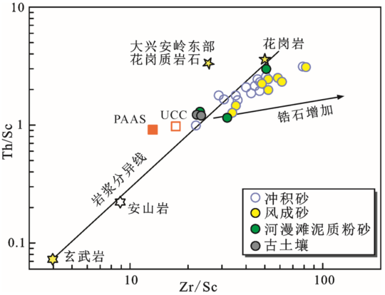
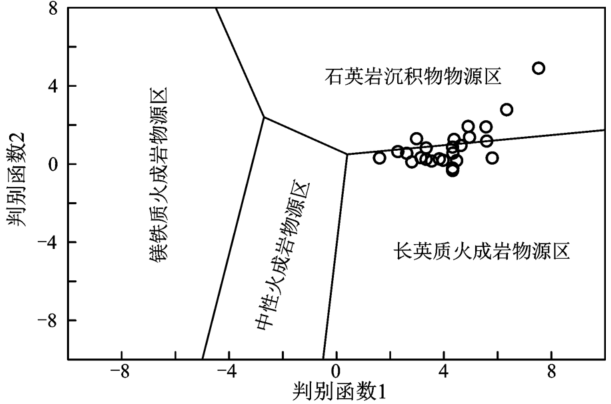
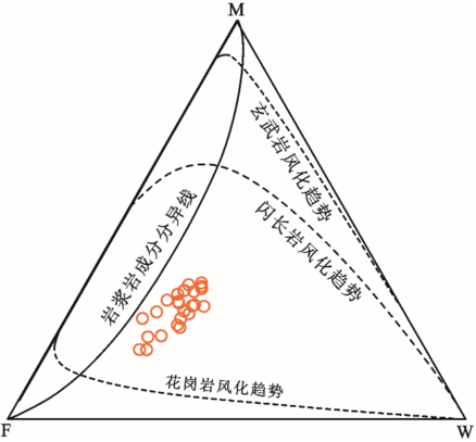
Th/Sc与Zr/Sc二元图解是最经典的反映沉积物分选和再循环作用的地球化学手段[22]。沉积分选及再循环易导致沉积物中某些稳定重矿物的富集(比如锆石),从而引起一些元素富集,比如Zr。由于Zr主要富集在锆石中,因此Zr/Sc比值可用于反映由于分选和再循环等沉积过程导致的锆石的增加;而Th/Sc比值常用于诊断沉积物的长英质与铁镁质来源,是岩浆化学分异过程的良好指示剂。对于首次循环的沉积物,Zr/Sc和Th/Sc比值常表现出相似的变化程度,即沉积物沿岩浆成分趋势线呈线性分布(图3);对于再循环沉积物,Zr/Sc比值表现出很大的变化,而Th/Sc比值则表现出平缓的变化,即,沉积物偏离岩浆成分趋势线,沿着代表了分选和再循环沉积作用的趋势线分布。对于杜蒙沙地而言(图3),一部分样品(主要是河流沉积物)沿着岩浆组成趋势线分布,反映了这部分样品最少受到分选和再循环沉积的影响,是首次循环的沉积。值得注意的是,古土壤也沿着岩浆成分趋势线分布,表现出与河流沉积物相同的初次循环特征,这与野外地层出露情况完全一致,灰褐色的古土壤以夹层的形式出现在河流冲积物之中,表明古土壤是河流沉积物发育的结果;而部分样品(主要是风成砂)偏离了岩浆分异趋势,具有较高的Zr/Sc比值,反映了这部分样品明显受到分选和再循环沉积的影响,是再循环的沉积。需要注意的是,杜蒙沙地样品沿PASS、UCC和花岗岩趋势分布,并聚集在花岗岩及大兴安岭东部花岗质岩浆岩的周围,说明杜蒙沙地初始源区的中酸性母岩的属性。在Roser and Korsch[26]基于7个常量元素建立的物源判别函数二元图解中(图4),杜蒙沙地样品落在石英质沉积物源区与长英质火成岩物源区,进一步表明了杜蒙沙地样品是大多数初次循环(来源于中酸性岩浆母岩)和少数再循环沉积的混合。杜蒙沙地大部分沉积物(比如河流沉积物)是大兴安岭东侧中酸性岩浆母岩风化剥蚀的产物经过嫩江及其支流搬运至此沉积形成,系初次循环的物质,少数样品(比如风成沙)是就地再次搬运堆积形成,系再循环沉积物质。
图3 杜蒙沙地Th/Sc-Zr/Sc判别
注:UCC和PASS值参考文献[
Fig.3 Th/Sc vs. Zr/Sc bivariate plot for the Harbin loess-paleosol sediments
图4 杜蒙沙地常量元素物源组成判别
判别函数1=30.638×TiO2/Al2O3-12.541×Fe2O3T/Al2O3+7.329×MgO/Al2O3+12.031×Na2O/Al2O3+35.42×K2O/Al2O3-6.382;判别函数2=56.500×TiO2/Al2O3-10.879×Fe2O3T/Al2O3+30.875×MgO/Al2O3-5.404×Na2O/Al2O3+11.112×K2O/Al2O3-3.89。
Fig.4 Provenance discrimination function diagram for the source rock signatures of the Dumeng Sandy Land
风化指数WIP(Weathering Index)可用于估算沉积物的化学风化程度甚至区分初次循环和再循环沉积[27]。WIP=100×(CaO*/0.7+2Na2O/0.35+2K2O /0.25+MgO/0.9),这里的常量元素含量用摩尔浓度表示,CaO*是硅酸盐中的CaO含量。WIP简单反映了沉积物Ca、Na、K和Mg的浓度,随着化学风化和再循环的增强,WIP越低。另外,WIP参数受石英稀释的影响,随石英含量的增加而降低,故高估了富含石英沉积物的风化程度。近年来,CIA结合WIP的二元图解被用来辨析沉积物的初次循环、再循环沉积和化学风化[27]。即使在风化程度很强地区,初次循环沉积物的CIA/WIP比值很少超过10,而多次循环沉积物的CIA/WIP比值通常大于10,甚至达到100左右[27]。杜蒙沙地的CIA/WIP比值全部小于1,意味着沉积物来源于首次循环。在图5中,杜蒙沙地样品分布在风化线的下方,且紧紧靠近风化线,表明了杜蒙沙地沉积物的再循环程度低,主要由初次循环的沉积物组成。
图5 首次循环和再循环沉积物的CIA-WIP二元判别图解
Fig.5 Distinguishing first-cycle and recycling sediments with chemical weathering indices
从岩浆母岩风化剖面中总结出来的MFW三角图解[28]可以用来反映岩浆母岩的化学风化程度和趋势以及沉积物初始母岩的组成,甚至用于区分首次循环和再循环沉积[29]。MFW图解包括了8个常量元素,使得它比CIA及A-CN-K图解更敏感地反映了沉积物的化学风化过程。M和F分别代表了未风化的铁镁质和长英质岩浆母岩,而W度量了岩浆母岩的风化程度。在MFW三角图解中,如果沉积物是直接来源于岩浆母岩(即初次循环的沉积物),则沉积物组成的趋势线与岩浆岩组成趋势线相交(图6);反之,如果是再循环沉积物,则样品点组成的趋势线不会与岩浆组成趋势线相交。对于杜蒙沙地而言,样品点大致平行于岩浆组成趋势线分布,表明了沉积物的再循环特征。
图6 首次循环和再循环沉积物的MFW判别图解
Fig.6 The MFW plots served as Distinguishing first-cycle from recycling sediments
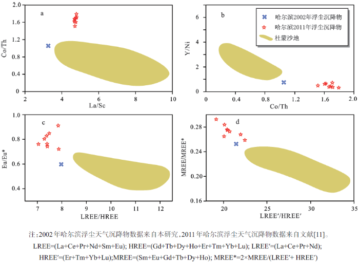
中国黄土的沙漠起源[7,30]和近源性[12]属性使得我们有理由推测松嫩沙地是东北平原中东部沙尘天气的潜在物源区。正是基于这样的认识,作为松嫩沙地最大的一块,杜蒙沙地传统上被认为是东北平原中东部西北方向的重要沙尘源[31],但缺乏有力证据,特别是地球化学方面的证据。哈尔滨位于东北平原西部沙地的东缘,杜蒙沙地的下风向。我们对2002年3月19~21日和2012年5月11~13日影响中国北方广大地区的2次尘暴天气沉降物[11,32]与杜蒙沙地沉积物进行地球化学对比,分析杜蒙沙地对下风向地区的大气粉尘释放。
不活动元素的地球化学记录了沉积物的物源及源区组成,这是因为:在风化、剥蚀和搬运过程中,某些不活动元素(如REE、Th、Sc、Co等)表现十分稳定,几乎等量地从源区通过搬运进入沉积记录,因此很好地赋存了母岩的性质[15,33~35]。一些不活动元素比值,如La/Sc, Th/Sc, Co/Th, Al2O3/TiO2和REE等因不受石英稀释和动力分选的影响[15,16]而优先被选择用来解析物源[11]。由不活动元素比值构建的物源判别图解提供了对风尘物质与可能源区之间可能联系的直观理解(图7),哈尔滨2次浮尘天气沉降物样品远离杜蒙沙地样品组成的区域,表明两者之间没有地球化学亲缘关系,暗示了杜蒙沙地不太可能为下风向的东北平原中东部地区提供风尘物质。这个认识也得到Sr-Nd同位素组成的支持。与OD、NMTP和NBC这3个区域及黄土高原黄土的Sr-Nd同位素组成都有明显区别(图8),杜蒙沙地的Sr-Nd同位素组成形成一个单独区域,而哈尔滨2次尘暴天气沉降物落在NBC区域内。这表明杜蒙沙地的Sr-Nd同位素组成明显不同于风尘沉降区的粉尘物质,进一步说明杜蒙沙地不太可能向东北平原中东部地区贡献风尘物质。这也符合该地区的植被和地貌状况。杜蒙沙地虽然是松嫩沙地面积最大的一片沙地,但植被覆盖好,地表风蚀不明显,向大气释放的粉尘颗粒不多;风成砂丘零星分布,主要是一些小型的固定横向沙垄和丘状或短垄状的灌丛沙堆与草丛沙堆及不规则形生草沙丘[31]。无论是地势平坦的由河流冲积物组成的河间地或阶地面以及地形稍有起伏的风成固定沙丘,因风蚀作用而向大气释放的粉尘物质都很有限。低的粉尘释放量和短的粉尘搬运距离决定了杜蒙沙地释放的粉尘只能局限在很小的范围内。因此,综合植被、地貌和地球化学数据,杜蒙沙地对东北平原中东部甚至更远地方的粉尘贡献极其有限。
图7 不活动元素比值的物源判别图解
Fig.7 Provenance discrimination diagrams involving immobile elements
图8 杜蒙沙地的Sr-Nd同位素及与风尘物质、中国粉尘源区和黄土高原黄土的对比
Fig.8 Sr-Nd isotopic compositions of the Dumeng Sandy Land, in comparison to aeolian dust and dust provenance in China as well as loess in Chinese Loess Plateau
对杜蒙沙地不同成因类型沉积物的常量、微量和稀土元素以及Sr-Nd同位素组成等地球化学组成分析显示结果如下:① 杜蒙沙地的地球化学组成没有空间分异性;② 沙地处于化学风化的初级阶段,仅经历了低级的化学风化程度;③ 沙地的成分成熟度低,大部分沉积物(如河流沉积物)为首次循环沉积,是大兴安岭东侧中酸性岩浆母岩风化剥蚀的直接产物;少数沉积物(如风成沙)是就地再次搬运堆积形成,是再循环沉积物质;④ 不活动元素比值及Sr-Nd同位素比值构建的物源判别图解显示,杜蒙沙地与风尘物质没有地球化学亲缘关系,表明杜蒙沙地对东北平原中东部的大气风尘物质的贡献很小。
致谢:地球化学组成得到核工业北京地质研究院分析测试中心刘牧老师的大力支持,张红和谢雨希参加了部分野外取样工作,在此一并表示感谢。
The authors have declared that no competing interests exist.
| [1] |
Geochemical approaches to sedimentation, provenance, and tectonics [J].https://doi.org/10.1002/aehe.3640101003 URL [本文引用: 1] 摘要
Copyright not claimed on content prepared wholly by U.S. government employees within scope of theiremployment. Individual scientists are hereby granted permission, without fees or further requests to GSA, to use a single figure, a single table, and/or a brief paragraph of text in subsequent works and to makeunlimited copies of items in GSA's journals for noncommercial use in classrooms to further education and science. This file may not be posted to any Web site, but authors may post the abstracts only of theirarticles on their own or their organization's Web site providing the posting includes a reference to thearticle's full citation. GSA provides this and other forums for the presentation of diverse opinions andpositions by scientists worldwide, regardless of their race, citizenship, gender, religion, or politicalviewpoint. Opinions presented in this publication do not reflect official positions of the Society.
|
| [2] |
Mondal M E A, Satyanarayanan M. Geochemistry of Archean metasedimentary rocks of the Aravalli craton, NW India: Implications for provenance, paleoweathering and supercontinent reconstruction [J].https://doi.org/10.1016/j.jseaes.2016.05.019 URL [本文引用: 1] 摘要
Basement complex of the Aravalli craton (NW India) known as the Banded Gneissic Complex (BGC) is classified into two domains viz. Archean BGC-I and Proterozoic BGC-II. We present first comprehensive geochemical study of the Archean metasedimentary rocks occurring within the BGC-I. These rocks occur associated with intrusive amphibolites in a linear belt within the basement gneisses. The association is only concentrated on the western margin of the BGC-I. The samples are highly mature (MS m ) to very immature (MS i ), along with highly variable geochemistry. Their major (SiO 2 /Al 2 O 3 , Na 2 O/K 2 O and Al 2 O 3 /TiO 2 ) and trace (Th/Sc, Cr/Th, Th/Co, La/Sc, Zr/Sc) element ratios, and rare earth element (REE) patterns are consistent with derivation of detritus from the basement gneisses and its mafic enclaves, with major contribution from the former. Variable mixing between the two end members and closed system recycling (cannibalism) resulted in the compositional heterogeneity. Chemical index of alteration (CIA) of the samples indicate low to moderate weathering of the source terrain in a sub-tropical environment. In A-CN-K ternary diagram, some samples deceptively appear to have undergone post-depositional K-metasomatism. Nevertheless, their petrography and geochemistry (low K 2 O and Rb) preclude the post-depositional alteration. We propose non-preferential leaching of elements during cannibalism as the cause of the deceptive K-metasomatism as well as enigmatic low CIA values of some highly mature samples. The Archean metasedimentary rocks were deposited on stable basement gneisses, making the BGC-I a plausible participant in the Archean Ur supercontinent.
|
| [3] |
The controls on the major- and trace-element evolution of shales, siltstones and sandstones of Ordovician to Tertiary age in the Wet Mountains region, Colorado, U.S.A .[J].https://doi.org/10.1016/0009-2541(95)00050-V URL [本文引用: 1] 摘要
A vertical section of shales, siltstones and sandstones from Ordovician to Eocene age in a limited geographic area east of the Wet Mountains and Sangre de Cristo Mountains in Colorado have been analyzed for major elements and a variety of trace-element concentrations, including the REE. In addition, the petrography of the sandstones has been determined.The quartz-rich arenites contain considerably lower concentrations of most elements relative to coexisting shales or siltstones at the same outcrop. The arkosic sandstones contain similar to lower concentrations of most elements compared to coexisting shales or siltstones in the same area. Accordingly, the average concentrations of AlO, FeO, MgO, TiO, LOI, Rb, Th, Co, Sc, Cr, Cs, Nb, Y and REE are significantly lower in all sandstones relative to all shales and siltstones. The exceptions are SiO, NaO and Ba concentrations, and the Eu, La and Th ratios as they are higher in the sandstones than the shales and siltstones. There is no significant difference in the MnO, CaO, KO and Sr concentrations or the La,Th , La, Cr and (La)ratios of the average sandstones relative to the shales and siltstones. Many of these differences may be related to the higher quartz and feldspar and lower clay mineral amounts in the sandstones than in the shales and siltstones. For example, average La, Th, La, Euand (La)ratios of the arkosic sandstones tend to be higher than the coexisting shales and siltstones due to enrichment of the arkoses in feldspar relative to the other minerals (e.g.,Eu= 0.82+0.19 in average arkoses in the Trinidad, Vermejo, Raton, Poison Canyon and Cuchara Formations; Eu= 0.63+0.19 in average shales and siltstones in the same formations). In addition, the elemental concentrations and ratios are more variable for most elements in the sandstones than the shales and siltstones. This suggests that the shales are rapidly homogenized near the source.The elemental fractionation in the arkosic sandstones due to enrichment of feldspar relative to other minerals suggests that they are poorer indicators of provenance that the associated shales, whereas, the more homogeneous elemental distributions in the shales and siltstones suggest that they may be better indicators of provenance than the sandstones. Nevertheless, the elemental ratios that are most similar in the sandstones and in the shales and siltstones are consistent with their derivation from similar average intermediate to silicic source rocks.
|
| [4] |
The influence of sediment recycling and basement composition on evolution of mudrock chemistry in the southwestern United States [J].https://doi.org/10.1016/0016-7037(95)00185-9 URL [本文引用: 2] 摘要
This paper reports systematic changes in mudrock composition through time on a single continental crustal block. The changes reflect both sediment recycling processes and changes through time in the composition of crystalline material being added to the sedimentary system and are related to tectonic evolution as the block matures from a series of accreted arc terranes to a stable craton. The major and trace element distributions reflect different aspects of the provenance of the mudrocks in this study. Major elements record sediment recycling processes as well as changing proportions of sedimentary and first-cycle source rocks. With the exceptions of K O (which tends to increase), and SiO and Al O (which show no trend), most major oxides tend to decline in relative abundance in younger mudrocks. Patterns shown by the Index of Compositional Variability ([Fe O + K O + Na O + CaO + MgO + MnO + TiO ]/Al O ) and by K O/Al O indicate that the major oxide trends are due to decreasing proportions of nonclay silicate minerals and a concomitant increase in the proportion of clay minerals, probably due to decreasing input of first cycle detritus coupled with recycling of sedimentary material. Excursions from progressive trends, marked by increases in MgO, K O, and CaO, reflect episodes of large-scale input of nonclay first-cycle minerals from crystalline source rocks due to large-scale basement uplift. The chemistry of low-solubility trace elements, in contrast, is not sensitive to recycling effects and reflects the composition of first-cycle input. Incompatible elements are progressively enriched relative to compatible elements in younger mudrocks, and values for chondrite normalised rare earths elements also increase. In addition, the Eu anomaly becomes systematically more negative in younger samples. These trends cannot be explained by diagenetic or weathering processes, and, therefore, indicate that the proportion of fractionated granitic first-cycle detritus being added to the sedimentary system becomes greater with time. These results confirm the importance of tectonic setting in controlling mudrock chemistry, and also demonstrate that there is a dynamic relationship between the tectonic evolution of a continental block and the composition of its sedimentary mantle.
|
| [5] |
Mesoproterozoic-Neoproterozoic transition: Geochemistry, provenance and tectonic setting of clastic sedimentary rocks on the SE margin of the Yangtze Block, South China [J].https://doi.org/10.1016/j.jseaes.2006.04.006 URL [本文引用: 1] 摘要
The SE margin of the Yangtze Block, South China is composed of the Mesoproterozoic Lengjiaxi Group and the Neoproterozoic Banxi Group, with Sinian- and post-Sinian-cover. A geochemical study was undertaken on the Mesoproterozoic–Neoproterozoic clastic sediments in order to delineate the characteristics of the sediment source and to constrain the tectonic development and crustal evolution of South China. Our results show that the Mesoproterozoic clastic sediments have a dominant component derived from a metavolcanic-plutonic terrane, with a large of mafic component. There is a minor contribution of mafic rocks and older upper crustal rocks to the provenance. Strong chemical weathering in the source area occurred before transport and deposition. The provenance for the Neoproterozoic clastic sediments was most likely old upper continental crust composed of tonalite–granodiorite-dominated, tonalite–granodiorite–granite source rocks, which had undergone strong weathering and/or recycling. A minor component of older K-rich granitic plutonic rocks and younger volcanogenic bimodal rocks is also indicated. Based on the regional geology, the geochemical data and the inferred provenance, the Mesoproterozoic Group is interpreted as a successive sedimentary sequence, deposited in an extensional/rifting back-arc basin, adjacent to a >1.80 Ga continental margin arc-terrane. The progressive extension/rifting of the back-arc basin was followed by increasing subsidence and regional uplift during continental marginal arc-continent (the Cathaysian Block) collision at 651.0 Ga caused the deposition of the Neoproterozoic Group into back-arc to retro-arc foreland basin. Therefore, the depositional setting of the Proterozoic clastic sediments and associated volcanic rocks within the back-arc basin reflected basin development from an active continental margin (back-arc basin), with extension or rifting of the back-arc basin, to a passive continental margin.
|
| [6] |
Geochemistry of the Pliocene red clay formation in the Chinese Loess Plateau and implications for its origin, source provenance and paleoclimate change [J].https://doi.org/10.1016/S0016-7037(00)00571-8 URL [本文引用: 1] 摘要
Recent field observations and sedimentological studies suggest the eolian origin of the late Tertiary red clay formation underlying the Pleistocene loess-soil sequence in the Loess Plateau, thereby extending the wind-blown record from 鈭2.6 Ma down to 鈭7.0 Ma in north-central China. To address the source provenance of the red clay, major and trace element concentrations were analyzed on the samples from a north-south loess transect of the Loess Plateau and a red clay section at Jiaxian. Results show that there is a good agreement of both major and trace element compositions between the last glacial-interglacial loess-soil units and the Jiaxian red clay record. The REE distribution patterns of the loess-soil and red clay samples are remarkably similar in shape, with enriched LREE and fairly flat HREE profiles and clear negative Eu anomaly. The geochemical features of the red clay are also identical to those of upper continental crust. These chemical characteristics provide further evidence for eolian sedimentation of the red clay. From the relations both between Na 2O/Al 2O 3 and K 2O/Al 2O 3 ratios and between U/Pb and Th/Pb ratios, the eolian loess and red clay materials must have been subject to thorough sedimentary differentiation and moderate chemical weathering in the source area. The chemical similarity between soil unit S1 and the red clay implies that such an environment as occurred in the last interglacial period may have already formed in northwestern China during the late Tertiary. Comparison of down-section variations in elemental ratios with field observations of pedogenic development of the red clay suggests that CaO/Al 2O 3, Sr/Rb and Sr/Ba are more sensitive to climate changes than magnetic susceptibility, and can be used to reconstruct the climate history of the late Cenozoic.
|
| [7] |
Nd and Sr isotopic characteristics of Chinese deserts: implications for the provenances of Asian dust [J].https://doi.org/10.1016/j.gca.2007.04.033 URL [本文引用: 2] 摘要
Silicate Nd–Sr isotopes of the fine-grained fractions of the 10 major deserts and sandy lands in North China and the loess in Chinese Loess Plateau were systematically investigated. Wide ranges in Nd–Sr isotopic compositions have been observed. The results of the <75 μm silicate fractions show that the Nd–Sr isotopic compositions of each desert are quite homogeneous and unique. According to the geographic distribution of the deserts and their Nd–Sr isotopes of both the <75 and <5 μm silicate fractions, three isotopic regions of Chinese deserts can be identified: (A) the deserts on the northern boundary of China, with the highest ε Nd(0) > 617.0; (B) the deserts on the northern margin of Tibetan Plateau, with ε Nd(0) ranging from 6111.9 to 617.4; and (C) the deserts on the Ordos Plateau, with the lowest ε Nd(0) < 6111.5. The distribution of the threes isotopic regions is controlled by the tectonic setting in North China, which implies that the materials of the deserts are derived from the locally eroded rocks from the surrounding mountains and the Nd–Sr isotopic signatures of these deserts could be quit stable over the past million years on the sub-tectonic time scales if there is any desert at those times. The Nd–Sr isotopic compositions of the loess are mostly close to those of the deserts in isotopic region B, suggesting that the main source regions of the last glacial loess in the Chinese Loess Plateau are Badain Jaran Desert, Tengger Desert, and Qaidam Desert. Also, the comparison between the Nd–Sr isotopes of the <5 μm silicate fractions of the deserts and the ancient dust falls in the North Pacific and Greenland show that the Asian end members of these dust falls are derived most from the deserts in the isotopic region B and less from those in the isotopic region C.
|
| [8] |
Natural and anthropogenic sources of East Asian dust [J].https://doi.org/10.1130/G30031A.1 URL [本文引用: 4] 摘要
Nd-Sr isotopic signatures of loess, modern dust, and their potential source materials are systematically investigated to discriminate the natural and anthropogenic sources of eastern Asian dust. Chinese loess is an eolian deposit that has accumulated over the past few million years, and is characterized by a negative Nd-Sr isotopic correlation that implies binary sources for the natural background of eastern Asian dust. Loess in northeastern China shows the highest ε(0) value, while loess in western China has the lowest ε(0). Considering the Nd-Sr isotopic signatures of the potential sources, we propose that the high ε(0) end member is derived from the arid lands around the northern boundary of China while the low ε(0) end member originates from the deserts on the northern margin of the Tibetan Plateau. Chinese Loess Plateau deposits are dominated by northern margin Tibetan Plateau dust, suggesting a strong link between the thick eolian deposit in this region and the evolution of the Tibetan Plateau. The long-range transported spring dust in both Nanjing (south China) and Japan has an Nd-Sr isotopic composition similar to that of loess. However, spring dust in Beijing (north China) has a much lower ε(0) value, indicating an additional anthropogenic contribution of low ε(0) material, possibly from the sandy lands in the adjacent north and west.
|
| [9] |
Geochemical evidence for the provenance of middle Pleistocene loess deposits in southern China [J].https://doi.org/10.1016/j.quascirev.2010.08.004 URL [本文引用: 1] 摘要
The provenance of middle Pleistocene loess in the middle and lower reaches of the Yangtze River, the most intensively investigated loess deposits outside the Loess Plateau region in China, remains controversial. Identification of the provenance will provide crucial insight into the environmental implications of this valuable sedimentary archive, and into the potential role of the East Asian winter monsoon in transporting the dust from deserts in the Asian interior. In this study, geochemistry was used to compare the provenance of loess in the lower reaches of the Yangtze River in southern China with that inferred for loess deposits on the Loess Plateau in northern China. Compared with samples from the Loess Plateau, the <20渭m fraction in the loess deposits of southern China has higher TiO 2 /Al 2 O 3 , Zr/Nb, Zr/Al, Zr/Ti, Zr/Hf, Y/Al and La N /Sm N ratios, and lower Eu/Eu*, Th/Nb, Y/Nb and Al/Nb ratios. The clear distinction in immobile element ratios between samples from the two regions indicates that the loess deposits in the two regions have different provenances. The inferred difference in source area is also supported by variations in the major element composition of bulk samples obtained in this study and collected from published data. These lines of evidence indicate that the deserts in the Asian interior are not the primary provenance for the southern loess. It is suggested that the adjacent floodplains to the north of Yangtze River are the dominant dust sources, and the occurrence of sustained loess deposits in the lower reaches of the Yangtze River, currently an area of northern subtropical climate, is an indication of local aridification and strengthened winter monsoon activity during glacial periods as a regional response to the Middle Pleistocene climate transition around 0.8Ma. The role of the East Asian winter monsoon in transporting the dust from northern deserts to southern China has been overestimated in previous studies.
|
| [10] |
REE geochemistry of modern eolian dust deposits in Harbin city, Heilongjiang province, China: Implications for provenance [J].https://doi.org/10.1016/j.catena.2014.07.008 URL [本文引用: 1] 摘要
There has long been disagreement about the provenance of sandy dust deposits in Harbin city, Heilongjiang province, China. The present paper contributes to a better understanding of the source of sandy dust deposits in Harbin by the application of REE geochemistry. The REE composition of samples from sand–dust deposit events in Harbin was compared with that of three different grain size fractions (<021102μm, 11–3002μm and 30–6302μm) of sandy soil samples from Horqin Sandy Land and Songnen Sandy Land. The results indicate that the REE distributions of all of the Harbin sand–dust samples are remarkably similar to each other, with distinct negative Eu anomalies and slightly negative Ce anomalies, indicating a stable provenance. Grain size exerts a significant influence on REE compositions, with a negative Eu-anomaly tending to develop with decreasing grain size. However, Ce is less influenced by grain size. The large lines of evidences, such as REE contents, distribution patterns, characteristic parameters, δEu (δEu02=02Eu anomalies values) vs. ΣREEs diagram, δEu vs. (LREE/HREE) diagram and (LREE/HREE) vs. La N (subscript N represents chondrite normalized values) diagram, indicate that REE composition of dust deposits in Harbin is quite similar to that of samples from Horqin Sandy Land, especially in the case of the 11–3002μm grain size fraction. This indicates that the Harbin sand–dust deposits are derived from Horqin Sandy Land and not from Songnen Sandy Land, and that material contribution of Horqin Sandy Land to Harbin dust deposits was mainly 11–3002μm grain-size fraction. The importance of the Horqin Sandy Land as a major source of Harbin sand–dust weather is supported by meteorological records and meteorological data.
|
| [11] |
Geochemical investigation of dry- and wet-deposited dust during the same dust-storm event in Harbin, China: Constraint on provenance and implications for formation of aeolian loess [J].https://doi.org/10.1016/j.jseaes.2016.01.025 URL [本文引用: 3] 摘要
A strong dust-storm event occurred in Harbin, China on May 11, 2011. The dry- and wet-deposited dust depositions in this dust-storm event, together with the surface sediments from the potential sources, were collected to study grain size distributions, carbonate content and carbon isotopic composition of carbonate, major element, trace element and rare earth elements (REE), and Sr–Nd isotopic compositions. The results indicate as follows. The dry-deposited dusts are characterized by bimodal grain-size distributions with a fine mode at 3.602μm and a coarse mode at 2802μm whereas the wet-deposited dusts are indicative of unimodal grain-size modes with a fine mode at 602μm. The dust-storm depositions are influenced to a certain extent by sedimentary sorting and are of a derivation from the recycled sediments. Based on identifying the immobility of element pairs before constraining sources of dust-storm deposits using geochemical elements, in conjunction with REE and especially Sr–Nd isotopic compositions, the primary and strengthening sources for the dust-storm event were detected, respectively. The Hunsandake Sandy Land as the primary source and the Horqin Sandy Land as the strengthening source were together responsible for the derivation of dust depositions during dust-storm event. The Hunsandake Sandy Land, however, contributes less dust to the dust-storm event in Harbin compared to the Horqin Sandy Land, and the Hulun Buir Sandy Land is undoubtedly excluded from being one of the sources for dust-storm depositions in Harbin. There are not notable differences in geochemical (especially Sr–Nd isotopic) compositions between dry- and wet-deposited dusts, indicating that the wet-deposited dust is of identical derivation to the dry-deposited dust. Based on our observations, it is of interest to suggest that fine and coarse particles in the CLP (Chinese Loess Plateau) loess possibly have the same sources.
|
| [12] |
Geochemical studies on the source region of Asian dust [J].https://doi.org/10.1007/s11430-011-4269-z URL [本文引用: 2] 摘要
The North China and the neighbouring Mongolia in Asian Interior is characterized by extremely dry climate, resulted in one of the world-檚 major dust emission centres. Deciphering the source region of Asian dust is critical for revealing the mechanism of the dust production, interpreting the paleo-environmental records of eolian deposits, predicting the overall environmental effects of dust, and setting the strategies for the control of contemporary dust storms. This paper summarizes the geochemical methods applied to the source tracing of Asian dust. Nd-Sr isotopes were the most extensively studied source tracer of Asian dust and have been successfully applied in many cases. Geochemistry of detrital monomineral shows great theoretical advantages in source tracing and deserves further studies. The short-range transportation of Chinese loess with direction similar to that of the prevailing near surface wind is revealed. Source tracing also shows that the Asian dust has two ultimate material sources from the northern margin of the Tibetan Plateau and the Central Asian Orogen, which confirms the importance of mountain processes in the production of silt eolian particles. Based on the recent progresses on the source tracing of Asian dust, discussions are expanded on the natural background of Asian dust storms and potential anthropogenic influence, the materials evolution of the source regions of Asian dust and its relationships with climate changes and Tibetan uplift, and the role of Tibetan uplift in the Asian dust system.
|
| [13] |
松嫩平原杜蒙沙地地表物质的地化组成及风化特征 [J].https://doi.org/10.7522/j.issn.1000-694X.2013.00143 Magsci [本文引用: 1] 摘要
本文分析了杜蒙沙地表土样品各粒级组分(全样、>63 μm、63~30μm、30~11 μm和<11 μm)的常量元素组成。结果表明:杜蒙沙地地表物质化学元素组成以Si、Al为主,与上地壳相比,除Si、Mn和Ti外,Fe、Mg、Ca和P严重亏损,Al和Na中度亏损,K轻微亏损;除Si、Al、Na、K外,Fe、Mg、Ca、Ti、P、Mn的变异系数均很高;常量元素在不同粒级中的变化程度按照Al<Si<Na<K<P<Fe<Ti<(Ca,Mn)<Mg的顺序依次递增,Al在不同粒级中的变化很小。Fe、Mg、Ca、Mn、Ti和P随着粒度的变细,含量逐渐增加,而Si、Na和K则相反,Al与粒度不存在明确的相关关系。化学风化指标按照CIA(化学蚀变系数)<(Al+Fe+Ti+Mn)/(Mg+Ca+K+Na)<(CaO+K2O+Na2O)/Al2O3<Fe2O3/MgO<K2O/Al2O3<(CaO+MgO+Na2O)/TiO2的顺序受粒度的影响依次增大, CIA是最好的化学风化指标,其次是(Al+Fe+Ti+Mn)/(Mg+Ca+K+Na)和(CaO+K2O+Na2O)/Al2O3,然后是Fe2O3/MgO和K2O/Al2O3,(CaO+MgO+Na2O)/TiO2比值受沉积物粒度的影响较大,不适合作为指示沉积物化学风化程度的指标。杜蒙沙地的CIA值为52.28,A-CN-K图解指示了杜蒙沙地处于化学风化的最初阶段,处于较弱的脱Ca、Na阶段,其他元素未发生明显化学风化或迁移;A-CNK-FM图解表明杜蒙沙地的Fe、Mg元素仅发生了微弱分异,原因在于半干旱、半湿润气候条件下杜蒙沙地微弱的机械风化,另外杜蒙沙地物质来源决定的短距离搬运也使Fe、Mg元素的分异不明显。
Geochemical characteristics and weathering feature of surface sediment in Dumeng sandy land, Northeast China .https://doi.org/10.7522/j.issn.1000-694X.2013.00143 Magsci [本文引用: 1] 摘要
本文分析了杜蒙沙地表土样品各粒级组分(全样、>63 μm、63~30μm、30~11 μm和<11 μm)的常量元素组成。结果表明:杜蒙沙地地表物质化学元素组成以Si、Al为主,与上地壳相比,除Si、Mn和Ti外,Fe、Mg、Ca和P严重亏损,Al和Na中度亏损,K轻微亏损;除Si、Al、Na、K外,Fe、Mg、Ca、Ti、P、Mn的变异系数均很高;常量元素在不同粒级中的变化程度按照Al<Si<Na<K<P<Fe<Ti<(Ca,Mn)<Mg的顺序依次递增,Al在不同粒级中的变化很小。Fe、Mg、Ca、Mn、Ti和P随着粒度的变细,含量逐渐增加,而Si、Na和K则相反,Al与粒度不存在明确的相关关系。化学风化指标按照CIA(化学蚀变系数)<(Al+Fe+Ti+Mn)/(Mg+Ca+K+Na)<(CaO+K2O+Na2O)/Al2O3<Fe2O3/MgO<K2O/Al2O3<(CaO+MgO+Na2O)/TiO2的顺序受粒度的影响依次增大, CIA是最好的化学风化指标,其次是(Al+Fe+Ti+Mn)/(Mg+Ca+K+Na)和(CaO+K2O+Na2O)/Al2O3,然后是Fe2O3/MgO和K2O/Al2O3,(CaO+MgO+Na2O)/TiO2比值受沉积物粒度的影响较大,不适合作为指示沉积物化学风化程度的指标。杜蒙沙地的CIA值为52.28,A-CN-K图解指示了杜蒙沙地处于化学风化的最初阶段,处于较弱的脱Ca、Na阶段,其他元素未发生明显化学风化或迁移;A-CNK-FM图解表明杜蒙沙地的Fe、Mg元素仅发生了微弱分异,原因在于半干旱、半湿润气候条件下杜蒙沙地微弱的机械风化,另外杜蒙沙地物质来源决定的短距离搬运也使Fe、Mg元素的分异不明显。
|
| [14] |
地球化学组成在不同粒级中的分布特征: 以哈尔滨城市道路表土为例 [J].
将哈尔滨城市道路表土样品进行粒度分级, 测定各粒级组分的常量元素、碳酸盐含量和碳酸盐碳同位素组成。结果显示, 常量元素在不同粒级中的变化程度依次为:Al < Na < Si < K < Ca、Mg < Fe < Mn < P < Ti;Fe、Mg、Ca、Mn、Ti 和P 随粒度变细含量逐渐增加, 而Si、Na 和K元素则相反, Al 元素与粒度的关系不清晰。化学风化指标按照以下的顺序受粒级的影响依次增大:CIA、(Al+Fe+Ti+Mn)/(Mg+Ca+K+Na) < (CaO+K2O+Na2O)/Al2O3 < Fe2O3/MgO < K2O/Al2O3 < (CaO+MgO+Na2O)/TiO2。碳酸盐含量在各粒级组分中变化幅度较大, 且随着粒度的变细, 碳酸盐含量逐渐增加。碳酸盐δ13C值在各粒级组分中的变化幅度较小, 与粒级的关系较为复杂。
The distribution of geochemical characteristics in different grain-size fractions: a case study of road surface soils in Harbin City .
将哈尔滨城市道路表土样品进行粒度分级, 测定各粒级组分的常量元素、碳酸盐含量和碳酸盐碳同位素组成。结果显示, 常量元素在不同粒级中的变化程度依次为:Al < Na < Si < K < Ca、Mg < Fe < Mn < P < Ti;Fe、Mg、Ca、Mn、Ti 和P 随粒度变细含量逐渐增加, 而Si、Na 和K元素则相反, Al 元素与粒度的关系不清晰。化学风化指标按照以下的顺序受粒级的影响依次增大:CIA、(Al+Fe+Ti+Mn)/(Mg+Ca+K+Na) < (CaO+K2O+Na2O)/Al2O3 < Fe2O3/MgO < K2O/Al2O3 < (CaO+MgO+Na2O)/TiO2。碳酸盐含量在各粒级组分中变化幅度较大, 且随着粒度的变细, 碳酸盐含量逐渐增加。碳酸盐δ13C值在各粒级组分中的变化幅度较小, 与粒级的关系较为复杂。
|
| [15] |
McLennan S M. The continental crust: Its composition and evolution [M]. |
| [16] |
Geochemistry of Archean shales from the Witwatersrand Supergroup, South Africa: Source-area weathering and provenance [J].https://doi.org/10.1016/0016-7037(87)90293-6 URL [本文引用: 2] 摘要
Compared to present-day upper continental crust, all but the Orange Grove, Roodepoort, and K8 shales appear to have been derived from continental sources depleted in LILE, REE, and HFSE and enriched in transition metals. Computer mixing models based on six relatively immobile elements (Th, Hf, Yb, La, Sc, Co) and four source rocks indicate that the relative proportions of granite, basalt and komatiite increased with time in sediment source areas at the expense of tonalite. The contributions of basalt and komatiite appear to reach a maximum during deposition of the Booysens shale, and granite during deposition of the K8 shales and possibly during deposition of the Orange Grove shales.
|
| [17] |
Unraveling the effects of potassium metasomatism in sedimentary rocks and Paleosols, with implications for paleoweathering conditions and provenance [J].https://doi.org/10.1130/0091-7613(1995)0232.3.CO;2 URL [本文引用: 2] 摘要
Lutites are commonly metasomatized during diagenesis, but the analysis presented here accounts for most postdepositional change. Potassium metasomatism is particularly common, and typically involves the conversion of kaolin (residual weathering product) to illite by reaction with K-bearing pore waters. Sandstones also undergo K metasomatism, which involves the replacement of plagioclase by potassium feldspar. These changes can be identified petrographically and are quantitatively accounted for by techniques discussed herein. Bulk chemical analyses and ternary diagrams are used to determine the amount of K addition, premetasomatized sediment composition, and composition of provenance areas. The premetasomatized mineralogy of paleosols can be compared with the mineralogy of recent soil profiles and thus, climate and topographic conditions determined for past weathering events. Some weathering indices lead to erroneous conclusions because, by excluding KO from consideration, correction cannot be made for metasomatic effects.
|
| [18] |
Early Proterozoic climates and plate motions inferred from major element chemistry of lutites [J].https://doi.org/10.1038/299715a0 URL [本文引用: 1] 摘要
The early Proterozoic Huronian Supergroup of the north shore of Lake Huron (Fig. 1) is a thick (up to 12,000 m) succession of sedimentary and volcanic rocks deposited between about 2,500 and 2,100 Myr ago 1 . Here we present a palaeoclimatic interpretation of the Huronian based on approximately 200 major elements analyses of lutites. Most of these are new analyses from the Gowganda and Serpent Formations (Fig. 2). The remainder are from published sources cited in Fig. 4. The composition of lutites from the Huronian Supergroup records an early period of intense, probably tropical, weathering followed by climatic deterioration that culminated in widespread deposition of glaciogenic sediments of the Gowganda Formation. Climatic amelioration followed during deposition of the succeeding Huronian formations. The Huronian succession can be interpreted using a uniformitarian approach in that present day seafloor spreading rates and latitude-related climatic variations are compatible with available geochronological and palaeomagnetic data.
|
| [19] |
Weathering and Global Denudation [J].https://doi.org/10.1086/648222 URL [本文引用: 1] |
| [20] |
Prediction of some weathering trends of plutonic and volcanic rocks based on thermodynamic and kinetic considerations [J].https://doi.org/10.1016/0016-7037(84)90408-3 URL [本文引用: 1] 摘要
The exposed crust consists mainly of plagioclase (35%), quartz (20%), K-feldspar (11%), volcanic glass (12%), biotite (8%), and muscovite (5%). Quartz is a resistate, thus feldspars and glass represent approximately 75 percent of the labile minerals. The weathering characteristics of these constituents are summarized in the context of thermodynamic, mass balance and kinetic considerations. Experimentally determined release rate constants were used to predict the proportions of Ca, Na and K released by feldspars of plutonic rocks (granites to gabbros) to weathering solutions. The chemical weathering trends of the weathered residues, calculated from the kinetic data, conform closely to the initial trends observed in some recent weathering profiles, demonstrating the accuracy of the predictions. Since the weathering of feldspars is controlled by processes that should not change through geological time, the relative release rates of Ca, Na, and K from the feldspars of granitic rocks can be calculated for future and past episodes of continental weathering. Experimentally determined release rate constants are not available for a wide range of volcanic glass compositions, but the limited data indicate that compositional trends are predictable in weathering profiles developed on volcanic rocks. The kinetic data available for rhyolitic glasses accurately predict the initial weathering trends observed in a recent rhyolite weathering profile.
|
| [21] |
Formation and Diagenesis of Weathering Profiles [J].https://doi.org/10.1086/629290 URL [本文引用: 1] 摘要
Weathering reactions mainly involve the transformation of feldspars, phyllosilicates, amphiboles, pyroxenes, and volcanic glass to the secondary mineral groups, kandites, illites, smectites, vermiculites, and/or chlorites. Although mineralogical changes are complex, bulk compositional changes to weathering profiles, resulting from chemical weathering, are simple and predictable from kinetic, thermodynamic, and mass balance considerations. Predicted bulk compositional changes are corroborated by studies of Recent weathering profiles developed on a variety of plutonic and volcanic rocks under different climatic regimes. Unlike the mineralogical compositions of profiles, the bulk compositional trends are not noticeably modified by climate; consequently, the simple, predictable bulk compositional trends observed in recent profiles provide a "norm" to which ancient weathering profiles can be compared. Early diagenetic reactions may occur prior to burial of the profile by reaction of groundwaters with secondary weathering products. These often result in abnormally high accumulations of Si, $CO_{2}$, Ca, and Mg to form clay minerals (smectites) and carbonates. The accumulations may be used as indicators of (paleo-)water tables. Late diagenetic reactions occur during and following burial through reaction of basin waters, trapped seawater, or brines with minerals of profiles. Metasomatism is common and includes production of illites, smectites, and chlorites at the expense of kaolinite and reconstitution of partially degraded feldspars to form potash feldspar and albite. Reaction with seawater (high Na/K and Mg/K) results in Na- and Mg-metasomatism, yielding albite and chlorite at the expense of partially degraded feldspars and clay minerals. In contrast, K-metasomatism of buried weathering profiles is favored around the periphery of subsiding continental sedimentary basins where dilute continental ground waters display low Na/K values. NaCl-rich brines and high temperatures in the deep central parts of basins favor the formation of albite at the expense of K-feldspar.
|
| [22] |
|
| [23] |
Geochemistry of the Mesoproterozoic Lakhanda shales in southeastern Yakutia, Russia: implications for mineralogical and provenance control, and recycling [J].https://doi.org/10.1016/S0301-9268(00)00090-5 URL [本文引用: 1] |
| [24] |
Chemical composition and evolution of the upper continental crust: Contrasting results from surface samples and shales [J].https://doi.org/10.1016/0009-2541(93)90140-E URL [本文引用: 1] 摘要
ABSTRACT The average chemical composition of juvenile upper continental crust (UC) as a function of age is estimated from chemical analyses, geologic maps, stratigraphic sections and isotopic ages. High plutonic/supracrustal ratios in Archean UC may reflect in part a different mode of crustal formation prior to 2.5 Ga. Greenstones show an increase in felsic volcanics and graywackes in post-Archean successions, a drop almost to zero in the proportion of komatiites at the Archean-Proterozoic (A/P) boundary, and an increase in the proportion of andesites in the Phanerozoic.Compared to the Early Archean, Late and post-Archean UC are depleted in Mg, Cr, Ni and Co, and post-Archean UC is enriched in LILE (large-ion lithophile elements; K, Rb, Ba, Th, U), HFSE (high field strength elements; Ti, P, Zr, Hf, Nb, Ta, Y), and HREE (heavy rare-earth elements). Negative Eu anomalies characterize UC of all ages, although they are relatively small in Archean UC. Cratonic shales show the same secular compositional changes as UC with the following important exceptions: At the A/P boundary, only shales show a decrease in Fe, V and Sc and an increase in Na, Ca and Sr, and only UC shows a significant increase in HREE and Y. Although post-Archean UC has a larger Eu anomaly than Archean UC, it is clear that both Archean UC and Archean shales have negative Eu anomalies, and that shales give only a weak indication of an increasing Eu anomaly in UC formed after the Archean. In both UC and shales at the A/P boundary, Cr/Th, Ni/Co and Co/Th ratios decrease, whereas the Th/U ratio increases only in shales and not in UC.The lack of HREE depletion and the high Fe, V and Sc contents of Archean shales indicate these shales were not derived from sources similar in composition to exposed Archean UC. The shale sources, which are now removed by erosion, must have been composed largely of basalt (卤 komatiite) (60%) and granite (40%), with little contribution from HREE-depleted TTG (tonalite-trondhjemite-granodiorite), which now dominates in Archean exposures. This suggests strong vertical zonation in the Archean continents with granites intruded into greenstones at very shallow levels.Compositional changes in UC or/and shales at the A/P boundary can be explained in one of the four ways: (1) a greater amount of basalt and komatiite in Archean UC (high Cr and Ni in Archean UC and shales); (2) garnet/amphibole fractionation during production of TTG by partial melting of hydrous basaltic crust (low HREE and Y in Archean UC); (3) change in TTG magma source from descending slab or thickened crust to metasomatized mantle wedge (increase in LILE and LREE in post-Archean UC and shales); and (4) a decrease in the intensity of chemical weathering after the Archean (increase in Na, Ca and Sr in post-Archean shales).
|
| [25] |
Zircon U-Pb-Hf isotopes, bulk-rock geochemistry and petrogenesis of Middle to Late Triassic I-type granitoids in the Xing’an Block, northeast China: Implications for early Mesozoic tectonic evolution of the central Great Xing’an Range [J].https://doi.org/10.1016/j.jseaes.2016.01.012 URL [本文引用: 1] |
| [26] |
Provenance signatures of sandstone-mudstone suite determined using discriminant function analysis of major element data [J].https://doi.org/10.1016/0009-2541(88)90010-1 URL [本文引用: 1] 摘要
Sandstones and argillites from selected New Zealand greywacke terranes represent four differing provenance groups: P1 (mafic) — first-cycle basaltic and lesser andesitic detritus, represented by the Maitai terrane and part of the Caples terrane; P2 (intermediate) — dominantly andesitic detritus (Waipapa and Pelorus terranes); P3 (felsic) — acid plutonic and volcanic detritus (Torlesse terrane); and P4 (recycled) — mature polycyclic quartzose detritus (Greenland Group). Contrasts in major-element composition occur between the groups due to differing provenance. SiO 2 Al 2 O 3 and K 2 O Na 2 O ratios increase, and Fe 2O 3T + MgO decreases from P1 to P4, as a result of petrologic evolution (P1-P3) and sedimentary maturation (P4). Some parts of oxide or ratio variation diagrams are distinctive for each group, but considerable overlap occurs due to bulk compositional variation with decrease in grain size. This overlap is almost eliminated by discriminant function analysis using Al 2O 3, TiO 2, Fe 2O 3T, MgO, CaO, Na 2O and K 2O, and a plot of the first two functions gives effective separation between the four groups. Tests of the functions with analyses of volcanic and plutonic rocks from New Zealand and the Lau volcanic arc, additional sedimentary terranes of New Zealand, and published data of sedimentary suites from Australia and the Pacific margin give good results, suggesting that the method is a viable technique for provenance determination which is largely independent of grain-size effects. The functions are applicable only to rocks which lack significant biogenic fractions, or to those where analyses can be corrected for these inputs. A second set of functions using oxide Al 2 O 3 ratios are designed for samples influenced by biogenic sedimentation. Although classification and test results are adequate, results are mixed for suites of Tertiary and modern sediments with substantial calcareous or siliceous components from New Zealand, the Japan Trench and the Solomon Islands.
|
| [27] |
Weathering and relative durability of detrital minerals in equatorial climate: Sand petrology and geochemistry in the East African Rift [J].https://doi.org/10.1086/673259 URL [本文引用: 3] 摘要
This article investigates how, where, and to what extent the mineralogical and chemical composition of sand-sized sediments is modified by extreme weathering in modern equatorial settings, with the ultimate goal of learning to read climate from the sedimentary record. To single out the weathering effect, we studied the compositional trends of fluvial sands along the western branch of the East African Rift between 5掳S and 5掳N. The relative durability of different detrital components, as well as potential hydraulic-sorting and grain-size effects, were assessed by comparing samples with similar provenances in different climatic and environmental conditions or of different size classes within the same sample. Sands of equatorial central Africa at the headwaters of the Congo and Nile basins display the full spectrum of petrologic suites characterizing rift-shoulder and volcanic rift provenances. Unlike in arid Arabia, quartzose sands are not restricted to areas where detritus is recycled from prerift sedimentary covers. In a hot humid climate, weathering can effectively obliterate the fingerprint of parent rock lithology and produce a nearly pure quartz residue even where midcrustal basement rocks are being actively uplifted and widely unroofed. In such settings garnet is destroyed faster than hornblende, and zircon faster than quartz. Weathering control on detrital modes is minor only in the rain shadow of the highest mountains or volcanoes, where amphibole-dominated quartzofelicdspathic metamorphiclastic sands (Rwenzori Province) or clinopyroxene-dominated feldspatholithic volcaniclastic sands (Virunga Province) are generated. Our detailed study of the Kagera basin emphasizes the importance of weathering in soils at the source rather than of progressive maturation in temporary storage sites during stepwise transport and shows that the transformation of diverse parent rocks into a quartzose -渨hite sand- may be completed in one sedimentary cycle in hydromorphic soils of subequatorial lowlands. Micas and heavy minerals, which are less effectively diluted by recycling than main framework components, offer the best key to identify the original source-rock imprint. The different behavior of chemical indexes such as the CIA (a truer indicator of weathering) and the WIP (markedly affected by quartz dilution) helps us to distinguish strongly weathered first-cycle versus polycyclic quartz sands.
|
| [28] |
Statistical empirical index of chemical weathering in igneous rocks: A new tool for evaluating the degree of weathering [J].https://doi.org/10.1016/j.chemgeo.2007.02.017 URL [本文引用: 1] 摘要
Chemical weathering indices are useful tools in characterizing weathering profiles and determining the extent of weathering. However, the predictive performance of the conventional indices is critically dependent on the composition of the unweathered parent rock. To overcome this limitation, the present paper introduces an alternative statistical empirical index of chemical weathering that is extracted by the principal component analysis (PCA) of a large dataset derived from unweathered igneous rocks and their weathering profiles. The PCA analysis yields two principal components (PC1 and PC2), which capture 39.23% and 35.17% of total variability, respectively. The extent of weathering is reflected by variation along PC1, primarily due to the loss of Na 2O and CaO during weathering. In contrast, PC2 is the direction along which the projections of unweathered felsic, intermediate and mafic igneous rocks appear to be best discriminated; therefore, PC1 and PC2 represent independent latent variables that correspond to the extent of weathering and the chemistry of the unweathered parent rock. Subsequently, PC1 and PC2 were then mapped onto a ternary diagram (MFW diagram). The M and F vertices characterize mafic and felsic rock source, respectively, while the W vertex identifies the degree of weathering of these sources, independent of the chemistry of the unweathered parent rock. The W index has a number of significant properties that are not found in conventional weathering indices. First, the W index is sensitive to chemical changes that occur during weathering because it is based on eight major oxides, whereas most conventional indices are defined by between two and four oxides. Second, the W index provides robust results even for highly weathered sesquioxide-rich samples. Third, the W index is applicable to a wide range of felsic, intermediate and mafic igneous rock types. Finally, the MFW diagram is expected to facilitate provenance analysis of sedimentary rocks by identifying their weathering trends and thereby enabling a backward estimate of the composition of the unweathered source rock.
|
| [29] |
Measuring and adjusting the weathering and hydraulic sorting effects for rigorous provenance analysis of sedimentary rocks: a case study from the Jurassic Ashikita Group, south-west Japan [J].https://doi.org/10.1111/sed.2008.55.issue-6 URL [本文引用: 1] |
| [30] |
Source regions and formation of the loess sediments on the high mountain regions of northwestern China [J].https://doi.org/10.1006/qres.2002.2381 URL [本文引用: 1] 摘要
Loess on the high mountains of northwestern China is largely controlled by the topographic features, distributed mainly on the northern slopes of the Tianshan and Kunlun Mountains as well as in the Ili Valley (between the northern and central Tianshan ranges). Loess distributed in different regions has different ages, with the oldest (early Pleistocene) loess occurring in the Ili Valley. Geochemical, mineralogical and granulometric analyses demonstrate that the loess in the three different regions has different provenance. The loess on the northern Tianshan and Kunlun Mountains is mainly derived from the Junggar and Taklimakan Deserts, respectively, whereas the loess in the Ili Valley is derived mainly from the Sary090009Ishikotrau Desert located in the Republic of Kazakhstan. However, these deserts serve mostly as holding areas for the silts rather than original source regions. The production of the silt-sized particles is mainly associated with glacial abrasion and tectonic-induced rock denudation. Thus, the loess in the studied regions can be described as 090008mountainous090009 loess rather than simply 090008glacial090009 loess or 090008desert090009 loess. It is unlikely that the mechanisms of loess formation are the same in different regions, given their dependence on specific geomorphological conditions and associated processes.
|
| [31] |
|
| [32] |
哈尔滨2002年3月20日沙尘暴沉降物的粒度特征及其意义 [J].Grain size characteristic of sand-dust sediments in Harbin city and its implication . |
| [33] |
Rare earth element geochemistry of Australian Paleozoic graywackes and mudrocks: Provenance and tectonic control [J].https://doi.org/10.1016/0037-0738(85)90025-9 URL [本文引用: 1] 摘要
In the Paleozoic graywackes of eastern Australia there is an increase in the total abundance of rare earth elements (REE), a light to heavy REE ratio and a decrease in the chondrite normalized Eu anomaly with the increase in SiO 2/Al 2O 3 and K 2O/Na 2O ratios. This is due to the change in the dominant source rocks from andesite to dacite to granite-gneiss and sedimentary rocks. Similarly, an increase in total REE and a decrease in Eu anomaly is also seen in the associated mudrocks with the increase in total clay content. This correlation in Paleozoic sedimentary rocks suggests that the REE characteristics of terrigenous sedimentary rocks reflect the depositional tectonic setting of the basin. The oceanic island-arc-type graywackes are characterised by their lower total REE abundance, only slight enrichment of LREE over HREE, and the absence of a negative Eu anomaly on chondrite-normalised plots. The continental island arc type graywackes are discriminated by their higher REE abundance and La/Yb ratio, the presence of a small negative Eu anomaly on the chondrite normalised plots and the significant enrichment of Eu compared to PAAS (Post-Archean Average Australian Shale). The sedimentary rocks deposited on Andean-type active continental margins, passive margins, platform and cratonic basins are all characterised by the high enrichment of LREE over HREE and the presence of a pronounced negative Eu anomaly on chondrite-normalised plots and can not be discriminated from each other by REE patterns alone.
|
| [34] |
Crook K A W. Trace element characteristics of graywackes and tectonic setting discrimination of sedimentary basins [J].https://doi.org/10.1007/BF00375292 URL 摘要
The graywackes of Paleozoic turbidite sequences of eastern Australia show a large variation in their trace element characteristics, which reflect distinct provenance types and tectonic settings for various suites. The tectonic settings recognised are oceanic island arc, continental island arc, active continental margin, and passive margins. Immobile trace elements, e.g. La, Ce, Nd, Th, Zr, Nb, Y, Sc and Co are very useful in tectonic setting discrimination. In general, there is a systematic increase in light rare earth elements (La, Ce, Nd), Th, Nb and the Ba/Sr, Rb/Sr, La/Y and Ni/Co ratios and a decrease in V, Sc and the Ba/Rb, K/Th and K/U ratios in graywackes from oceanic island arc to continental island arc to active continental margin to passive margin settings. On the basis of graywacke geochemistry, the optimum discrimination of the tectonic settings of sedimentary basins is achieved by La-Th, La-Th-Sc, Ti/Zr-La/Sc, La/Y-Sc/Cr, Th-Sc-Zr/10 and Th-Co-Zr/10 plots. The analysed oceanic island arc graywackes are characterised by extremely low abundances of La, Th, U, Zr, Nb; low Th/U and high La/Sc, La/Th, Ti/Zr, Zr/Th ratios. The studied graywackes of the continental island arc type setting are characterised by increased abundances of La, Th, U, Zr and Nb, and can be identified by the La-Th-Sc and La/Sc versus Ti/Zr plots. Active continental margin and passive margin graywackes are discriminated by the Th-Sc-Zr/10 and Th-Co-Zr/10 plots and associated parameters (e.g. Th/Zr, Th/Sc). The most important characteristic of the analysed passive margin type graywackes is the increased abundance of Zr, high Zr/Th and lower Ba, Rb, Sr and Ti/Zr ratio compared to the active continental margin graywackes.
|
| [35] |
1991. Another look at rare earth elements in shales [J].https://doi.org/10.1016/0016-7037(91)90370-K URL [本文引用: 1] 摘要
Linear correlation and mass balance considerations indicate that clays are more important than zircon (or other heavy minerals) in hosting both light and heavy REE in cratonic shales. Considering the uniformity of the Eu anomaly and REE distributions in cratonic shales, it seems likely that detritus is thoroughly mixed during weathering and sediment transport and that the REE patterns in shales reflect the average REE pattern of the sources, regardless of the ratio of clays to heavy minerals in the shales. Shales, suspended river loads, and near-shore marine sediments all have broadly similar REE patterns, and reported HREE depletions in the latter two groups may reflect incomplete dissolution of heavy minerals during sample preparation. REE distributions in shales and suspended river loads determined by INNA are similar to those in average upper continent crust, and REE distributions in shale averages NASC and PAAS seem to be reasonably representative of the average composition of post-Archean upper continental crust.
|
| [36] |
Sr-Nd isotopic characteristics of eolian deposits in the Erdos Desert and Chinese Loess Plateau: Implications for their provenances [J].https://doi.org/10.2343/geochemj.42.273 URL 摘要
ABSTRACT Material sources of the northern deserts and the Loess Plateau in China are always one of the critical focuses in Quaternary and paleoclimate fields. In this paper, the method of Sr-Nd isotope geochemistry is applied to explore the relationship in material source between the Erdos desert and Chinese Loess Plateau. The εNd(0) value of the <75 μm silicate fraction between -11.8 and -17.2 is more positive in the west than in the east, and its 87Sr/86Sr ratio varies from 0.719218 to 0.714824 without similar characteristics in the Erdos desert. In addition, there are Sr-Nd isotopic differences between different grain-size fractions of eolian sand in the Erdos desert. The coarse-grained fractions mainly originated from local parent rock weathering, but the fine-grained fractions were probably affected by the input of foreign materials. Geographical distribution of Sr-Nd isotopes (especially Nd isotopes) of <75 μm silicate fractions indicates that the input of foreign materials into the Erdos desert decreases gradually from its west to east. The εNd(0) and 87Sr/86Sr values of eolian silicate fractions in the Chinese Loess Plateau vary from -9.2 to -13.56 and from 0.719957 to 0.714424, respectively in this study. The εNd(0) and 87Sr/86Sr values of eolian silicate fractions are different between the western-central and eastern Loess Plateau. According to Sr-Nd isotopic data from previous and present studies, the εNd(0) values of eolian silicate fractions in the western-central Loess Plateau mostly fall in a very narrow range of -965-11.5, suggesting a uniform source region. However, there is a large Sr isotope variation resulting from different pretreating methods employed by researchers. The εNd(0) and 87Sr/86Sr values of eolian silicate fractions in the eastern Loess Plateau both change markedly. The differences in Sr-Nd isotopes of eolian silicate fractions between the eastern and western-central Loess Plateau indicate that there are different sources for eolian silicate materials in the two sub-areas. Sr-Nd isotopes, especially Nd isotopes of the <75 μm silicate fractions in the Erdos desert are clearly different from those of eolian silicate fractions in the western-central part, but roughly close to those of eolian silicate fractions in the eastern part of the Chinese Loess Plateau, which shows that the Erdos desert was perhaps a main source for the eastern Loess Plateau but not for the western-central Loess Plateau.
|

/
| 〈 |
|
〉 |
